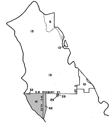
Seattle Annexation Map - Southwest portions
Background
The annexations in this map include the following neighborhoods*: West Seattle, Fauntleroy, Arbor Heights, Delridge, and South Delridge.
A comprehensive list of Seattle annexations and related ordinances is also available.
Back to the City annexation map.

| Map Area | District | Ordinance Number | Ordinance Approved | Effective Date Annexed |
|---|---|---|---|---|
| 26 | A portion of the NE 1/4 Section 1, T 23 N, R 3 E, WM | 74757 | 3/6/1946 | 4/8/1946 |
| 29 | A portion of the NE 1/4 Section 1, T 23 N, R 3 E, WM | 77429 | 10/20/1948 | 1/1/1949 |
| 32 | A portion of Assessor's Plat of Endolyne | 79226 | 8/22/1950 | 1/1/1951 |
| 41 | Arbor Heights in Sections 2, 3, and 11, T 23 N, R 3 E, WM | 83228 | 7/19/1954 | 9/1/1954 |
| 42 | Roxbury Heights in Sections 1 and 12, T 23 N, R 3 E, WM | 84568 | 10/31/1955 | 1/1/1956 |
* = All neighborhoods listed are based on neighborhood designations from the Seattle City Clerk's Neighborhood Atlas.

