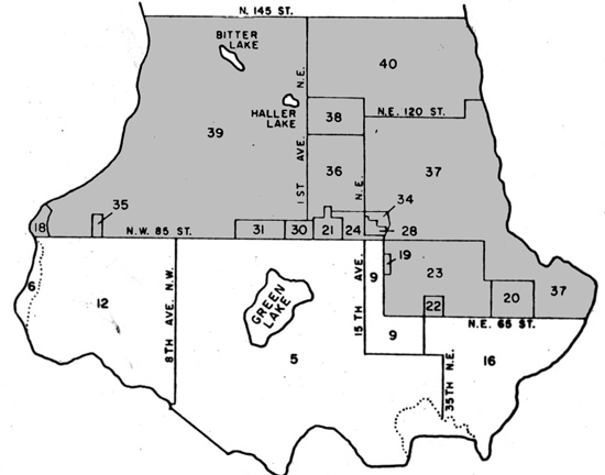
Seattle Annexation Map - North portions
Background
The annexations in this map include the following neighborhoods*: North Beach, Blue Ridge, Crown Hill, Greenwood, Broadview, Bitter Lake, Northgate, Haller Lake, North College Park, Mapple Leaf, Pinehurst, Lake City, Olympic Hills, Victory Heights, Cedar Park, Matthews Beach, Meadowbrook, Ravenna, Wedgewood, Bryant, View Ridge, and Sand Point.
A comprehensive list of Seattle annexations and related ordinances is also available.
Back to the City annexation map.

| Map Area | District | Ordinance Number | Ordinance Approved | Effective Date Annexed |
|---|---|---|---|---|
| 18 | Golden Gardens Park - county portion | 70142 | 9/20/1940 | 9/20/1940 |
| Amended by 70477 | 12/17/1940 | 12/17/1940 | ||
| 19 | Haynes Park District in Sonora Precinct | 71253 | 9/10/1941 | 10/10/1941 |
| 20 | A portion of Sandpoint Precinct | 71857 | 4/29/1942 | 5/29/1942 |
| 21 | Portions of Buchanan and Yarbo Precinct | 72266 | 11/10/1942 | 12/10/1942 |
| 22 | A portion of Ziria Precinct | 72412 | 2/10/1943 | 3/12/1943 |
| 23 | A portion of Sonora Precinct et al. | 73879 | 3/20/1945 | 4/19/1945 |
| 24 | A portion of Maple Leaf No. 1 Precinct et al. | 73880 | 3/20/1945 | 4/19/1945 |
| 28 | A portion of Maple Leaf No. 1 Precinct | 76962 | 4/28/1948 | 1/1/1949 |
| 30 | A portion of the SW 1/4 Section 32, T 26 N, R 4 E, WM | 78749 | 2/28/1950 | 3/30/1950 |
| 31 | A portion of the S 1/2 Section 31, T 26 N, R 4 E, WM | 78825 | 4/1/1950 | 5/1/1950 |
| 34 | A portion of the SW 1/4 Section 33, T 26 N, R 4 E, WM | 79228 | 8/22/1950 | 1/1/1951 |
| 35 | A portion of the SW 1/4 Section 35, T 26 N, R 3 E, WM | 80359 | 10/4/1951 | 1/1/1952 |
| 36 | Northgate District in Sections 29 and 32, T 26 N, R 4 E, WM | 81186 | 7/21/1952 | 8/20/1952 |
| 37 | Sand Point District in T 25 N and T 26 N, R 4 E, WM | 81655 | 1/13/1953 | 3/1/1953 |
| 38 | Pinehurst District in Section 29, T 26 N, R 4 E, WM | 81704 | 2/3/1953 | 3/1/1953 |
| 39 | Greenwood District in T 26 N, R 3 and 4 E, WM | 82425 | 11/2/1953 | 1/4/1954 |
| 40 | Lake City District in T 26 N, R 4 E, WM | 82426 | 11/2/1953 | 1/4/1954 |
* = All neighborhoods listed are based on neighborhood designations from the Seattle City Clerk's Neighborhood Atlas.

