![[HOME]](/netaicon/homeicon.gif)
![[SEARCH]](/netaicon/srchpage.gif)

![[CURR_LIST]](/netaicon/curlist.gif)


![[BOTTOM]](/netaicon/bottom.gif)
![[HELP]](/netaicon/help.gif)
Seattle City Council Bills and Ordinances
Information modified on September 25, 2012; retrieved on March 27, 2026 0:36 AM
Ordinance 123963
Introduced as Council Bill 117541
Title | |
|---|---|
Description and Background | |
|---|---|
| Current Status: | Passed |
| Fiscal Note: | Fiscal Note to Council Bill No. 117541 |
| Index Terms: | YESLER-TERRACE, LAND-USE-CODE, ZONING, LOW-INCOME-HOUSING, MIXED-USE-DEVELOPMENT, MIXED-INCOME-HOUSING, DEVELOPMENT-ACTIVITIES, TREES, PARKING, LIGHT-RAIL-TRANSIT, PUBLIC-TRANSIT, MASTER-USE-PERMITS |
| References: | |
Legislative History | |
|---|---|
| Sponsor: | CLARK |
| Date Introduced: | July 30, 2012 |
| Committee Referral: | Yesler Terrace |
| Committee Action Date: | August 16, 2012 |
| Committee Recommendation: | Pass as Amended |
| Committee Vote: | 9-0 |
| City Council Action Date: | September 4, 2012 |
| City Council Action: | Passed |
| City Council Vote: | 9-0 |
| Date Delivered to Mayor: | September 5, 2012 |
|
Date Signed by Mayor: (About the signature date) | September 10, 2012 |
| Date Filed with Clerk: | September 11, 2012 |
| Signed Copy: | PDF scan of Ordinance No. 123963 |
Text | |||||||||||||||||||||||||||||||||||||||||||||||||||||||||||||||||||||||||||||||||||||||||||||||||||||||||||||||||||||||||||||||||||||||||||||||||||||||||||||||||||||||||||||||||||||||||||||||||||||||||||||||||||||||||||||||||||||||||||||||||||||||||||||||||||||||||||||||||||||||||||||||||||||||||||||||||||||||||||||||||||||||||||||||||||||||||||||||||||||||||||||||
|---|---|---|---|---|---|---|---|---|---|---|---|---|---|---|---|---|---|---|---|---|---|---|---|---|---|---|---|---|---|---|---|---|---|---|---|---|---|---|---|---|---|---|---|---|---|---|---|---|---|---|---|---|---|---|---|---|---|---|---|---|---|---|---|---|---|---|---|---|---|---|---|---|---|---|---|---|---|---|---|---|---|---|---|---|---|---|---|---|---|---|---|---|---|---|---|---|---|---|---|---|---|---|---|---|---|---|---|---|---|---|---|---|---|---|---|---|---|---|---|---|---|---|---|---|---|---|---|---|---|---|---|---|---|---|---|---|---|---|---|---|---|---|---|---|---|---|---|---|---|---|---|---|---|---|---|---|---|---|---|---|---|---|---|---|---|---|---|---|---|---|---|---|---|---|---|---|---|---|---|---|---|---|---|---|---|---|---|---|---|---|---|---|---|---|---|---|---|---|---|---|---|---|---|---|---|---|---|---|---|---|---|---|---|---|---|---|---|---|---|---|---|---|---|---|---|---|---|---|---|---|---|---|---|---|---|---|---|---|---|---|---|---|---|---|---|---|---|---|---|---|---|---|---|---|---|---|---|---|---|---|---|---|---|---|---|---|---|---|---|---|---|---|---|---|---|---|---|---|---|---|---|---|---|---|---|---|---|---|---|---|---|---|---|---|---|---|---|---|---|---|---|---|---|---|---|---|---|---|---|---|---|---|---|---|---|---|---|---|---|---|---|---|---|---|---|---|---|---|---|---|---|---|---|---|---|---|---|---|---|---|---|---|---|---|---|---|---|---|---|---|---|---|---|---|---|---|---|---|---|---|---|---|---|---|---|---|---|
|
AN ORDINANCE related to land use and zoning, amending various chapters of Title 23 of the Seattle Municipal Code (SMC) to incorporate new zoning provisions for Yesler Terrace; adding a new SMC Chapter 23.75 to establish use provisions and development standards for the new Master Planned Community -Yesler Terrace (MPC-YT) zone, including an affordable housing incentive program as authorized by RCW 36.70A.540; amending SMC Section 25.05.800 to establish limits for categorical exemptions from environmental review in the MPC-YT zone; amending the Official Land Use Map, SMC Chapter 23.32, to rezone properties in the Yesler Terrace neighborhood from LR3 and DMR/C 65/65-85 to MPC-YT; approving and adopting Yesler Terrace Master Planned Community Design Guidelines; revising design review and platting procedures for the MPC-YT zone; and revising procedures for project review under a planned action ordinance; all to implement the Comprehensive Plan and to allow redevelopment of Yesler Terrace to achieve a mix of residential, commercial, and other uses; appropriate urban density; and more affordable housing, environmental sustainability, and publicly accessible open space than would be likely to result from development under existing zoning. BE IT ORDAINED BY THE CITY OF SEATTLE AS FOLLOWS: Section 1. Reserved. Section 2. Section 23.22.020 of the Seattle Municipal Code, which section was last amended by Ordinance 121291, is amended as follows:
23.22.020 Content of preliminary plat application((
A. Every preliminary plat application shall consist of one (( 1. The name of the proposed subdivision; 2. North arrow and scale; the location of existing property lines; streets, building, if any; watercourses and all general features; 3. The legal description of the land contained within the subdivision; 4. The names and addresses of all persons, firms and corporations holding interest in the lands, including easement rights and interest; 5. The proposed names, locations, widths, dimensions and bearings of proposed streets, alleys, easements, parks, lots, building lines, if any, and all other information necessary to interpret the plat, including the location of existing utility and access easements which are to remain, all horizontal references (any reference to bearings, azimuths, or geographical or state plane coordinates) shall reference the North American Datum of 1983 (1991 adjustment); 6. The location of streets in adjoining plats and the approximate locations of adjoining utilities and proposed extensions into the plat; 7. The names of adjoining plats; 8. The name, address and telephone number and seal of the registered land surveyor who made the survey or under whose supervision it was made; 9. The date of the survey; 10. All existing monuments and markers located by the survey; 11. The zoning classification applicable to the land within the subdivision; 12. The conditions of or the limitations on dedications, if any, including slope rights; 13. Contour intervals as required, based upon the North American Vertical Datum of 1988; 14. Property information including, but not limited to, address, legal description, and Assessor's Parcel number; 15. Evidence of ownership or authorization from the property owner to make the application; 16. A signed statement of financial responsibility by the applicant and owner acknowledging financial responsibility for all applicable permit fees; 17. Drainage plan; 18. Landscape plan;
19. Identification of any adjacent property within ((
20. Specific location and description of all at least (( B. Any plat submitted that covers only a part of the subdivider's tract shall be accompanied by a sketch showing the proposed future street system in the remainder of the tract so that the street layout of the tract may be considered as a whole. C. The plat shall comply with the technical requirements of Subchapter V. D. For a preliminary plat of property entirely within the MPC-YT zone, an applicant may propose a single final plat for the entire property covered in the preliminary plat, or multiple final plats with each final plat covering a portion of the property covered in the preliminary plat. If an applicant proposes to proceed with more than one final plat, then the preliminary plat application shall designate which portion of the property, and facilities and improvements, will be included in each final plat. Section 3. Section 23.22.028 of the Seattle Municipal Code, which section was last amended by Ordinance 118794, is amended as follows:
23.22.028 Effect of preliminary plat approval((
A. Approval of the preliminary plat shall constitute authorization for the subdivider to develop the subdivision facilities and improvements as required in the approved preliminary plat(( B. If the Hearing Examiner approves of the applicant proceeding with more than one final plat pursuant to subsection 23.22.054.B, then approval of the preliminary plat shall constitute approval for the use of multiple final plats.
(( Section 4. Section 23.22.054 of the Seattle Municipal Code, which section was last amended by Ordinance 119791, is amended as follows:
23.22.054 Public use and interest(( A. The Hearing Examiner shall inquire into the public use and interest proposed to be served by the establishment of the subdivision and dedication. The Hearing Examiner shall consider all relevant facts to determine whether the public interest will be served by the subdivision and dedication, and if it finds that the proposed plat makes appropriate provision for the public health, safety and general welfare and for open spaces, drainage ways, streets, alleys, other public ways, transit stops, potable water supplies, sanitary wastes, fire protection facilities, parks, playgrounds, sites for school and schoolgrounds, sidewalks and other planning features that assure safe walking conditions for students who walk to and from school, is designed to maximize the retention of existing trees, and that the public use and interest will be served by the platting of subdivision, then it shall be approved. If the Hearing Examiner finds that the proposed plat does not provide the appropriate elements or that the public use and interest will not be served, then the Hearing Examiner may disapprove the proposed plat. Dedication of land to any public body may be required as a condition of subdivision approval and shall be clearly shown on the final plat. The Hearing Examiner shall not as a condition to the approval of any plat require a release from damages to be procured from other property owners. B. If an applicant proposes to proceed with more than one final plat pursuant to subsection 23.22.020.D, the Hearing Examiner shall inquire into the feasibility of the proposed use of multiple final plats and shall approve or disapprove the use of multiple final plats as part of the preliminary plat decision. The Hearing Examiner shall approve the use of multiple final plats only if, in the event that fewer than all of the multiple final plats are completed, the public use and interest will still be served. If the Hearing Examiner approves use of multiple final plats, then the Hearing Examiner shall impose any conditions on the preliminary plat approval that may be necessary to serve the public use and interest in connection with the use of multiple final plats, including but not limited to conditions ensuring that street connectivity is maintained and that appropriate provision has been made for the facilities and improvements described in subsection 23.22.054.A to be provided in a timely manner to serve the property in each final plat. If the Hearing Examiner approves use of multiple final plats, then the Hearing Examiner shall designate in the preliminary plat approval the time period for completion of the facilities and improvements required for each final plat. Section 5. Section 23.22.064 of the Seattle Municipal Code, which section was last amended by Ordinance 123649, is amended as follows: 23.22.064 Filing with Director of Transportation A. Time of Filing.
1. A final plat (or final plats, if use of multiple final plats is authorized pursuant to Section 23.22.054.B) meeting all the requirements of RCW Chapter 58.17 and of this ((
2. Within 30 days of the date of filing of the final plat, unless the applicant consents to an extension of the time period, final plats shall be approved or disapproved by action of the Council, or returned to the applicant. This approval shall proceed
pursuant to the procedures of this (( *** C. Multiple Final Plats. If authorized in the preliminary plat approval, portions of an approved preliminary plat of property entirely within the MPC-YT zone may be processed and approved in more than one final plat filed within the time period specified in subsection 23.22.064.A (including any extension that may be granted pursuant to that subsection). Section 6. Subsection A of Section 23.22.066 of the Seattle Municipal Code, which section was last amended by Ordinance 123361, is amended as follows:
23.22.066 Technical standards for final plat((
A. (( 1. The name of the subdivision; 2. The lines, widths and names of all streets, avenues, places, parks or other public property, and the location of monuments marking the same; 3. The length and direction of all lot lines, also the angles made by lot lines with the street lines; 4. The location of control points and monuments together with all ties; 5. The names of all subdivisions immediately adjacent; 6. The scale and north point; 7. The boundary of the tract as covered by the plat showing courses and distance on the plat; 8. The initial point; 9. All protective improvements and restrictions on uses; and 10. All dedications and all conveyances to a homeowner's nonprofit maintenance corporation in lieu of dedication. *** Section 7. Section 23.22.070 of the Seattle Municipal Code, which section was last amended by Ordinance 118409, is amended as follows:
23.22.070 Director's action on final plat((
The Director of Transportation shall refer ((
A. That the proposed final plat bears the certificates and statements of approval required by state law and this (( B. That a title insurance report furnished by the subdivider confirms the title of the land and the proposed subdivision is vested in the name of the owners whose signatures appear on the plat certificate;
C. If use of multiple final plats is not authorized in the preliminary plat approval pursuant to subsection 23.22.054.B, (( D. If use of multiple final plats is authorized in the preliminary plat approval pursuant to subsection 23.22.054.B, that the facilities and improvements required by the preliminary plat approval as conditions to final plat approval have been completed, or alternatively, that the subdivider will provide a bond or other security in a form approved by the City Attorney and in an amount commensurate with the cost of improvements remaining to be completed, conditioned upon the construction and installation of improvements within a time period to be fixed by the City Council; E. In the case of any final plat of property in the MPC-YT zone, whether or not multiple final plats are used, if there are facilities and improvements required by the preliminary plat approval as conditions to development of all or part of the subdivided property, but not as conditions to final plat approval, that have not been completed at the time final plat approval is sought and the subdivider will not provide a bond or other security for completion of those improvements as set forth in subsections 23.22.070.C and 23.22.070.D, then: 1. the subdivider has submitted to the Director of Transportation and the Director of Transportation has approved a phasing plan that designates the particular facilities and improvements that must be completed as conditions to specified types or levels of development within particular areas of the final plat, consistent with the preliminary plat approval; and 2. each owner of any property where development is to be conditioned under the phasing plan has executed and delivered in recordable form a covenant against that property in favor of the City, to be recorded upon final plat approval, by which the owner agrees, on behalf of itself and its successors in interest and assigns, to construct the facilities and improvements required by the preliminary plat approval as conditions related to development on that property and not to construct any structure unless the facilities and improvements required by the preliminary plat approval have been completed to the extent required for such structure by the phasing plan approved by the Director of Transportation pursuant to subsection 23.22.070.E.1;
(( Section 8. Section 23.22.072 of the Seattle Municipal Code, which section was last amended by Ordinance 118409, is amended as follows:
23.22.072 Submission of final plat to Council((
A. Pursuant to the requirements of RCW 58.17.150, the Director of Transportation shall not modify the conditions or requirements made in the approval of ((
B. If the Director and the Director of Transportation determine that the requirements of this ((
C. If either Director determines that the requirements of this (( Section 9. Subsection A of Section 23.22.074 of the Seattle Municipal Code, which section was last amended by Ordinance 123649, is amended as follows: 23.22.074 Council determination of final plat A. The Council shall determine:
1. Whether (( 2. Whether the requirements imposed when the preliminary plat was approved have been met;
3. Whether the bond, if required by the City, is sufficient in its terms to assure completion of improvements; (( 4. Whether the covenant described in subsection 23.22.070.E.2, if required, has been executed in form and substance acceptable to the Council; and 5. Whether the requirements of state law and the Seattle Municipal Code that were in effect at the time of preliminary plat approval have been satisfied by the subdivider. *** Section 10. Section 23.22.078 of the Seattle Municipal Code, which section was last amended by Ordinance 123649, is amended as follows: 23.22.078 Resubmission A. Any final plat disapproved by the Council or returned to the applicant may, at the sub-divider's option, be resubmitted for approval upon satisfaction of the following conditions: 1. The sub-divider has corrected those deficiencies of the final plat, attachments to it, or improvements, any or all of which caused the final plat to be returned or disapproved;
2. The final plat is resubmitted within the time period specified in subsection 23.22.064.A (including any extension that may be granted pursuant to that subsection) (( 3. The final plat was not disapproved by Council with prejudice against resubmission; 4. The sub-divider has not accepted any proffered refund of filing fees paid for individual lots. B. Any subdivision, the final plat of which is disapproved for reasons of nonconformance with the approved preliminary plat and any requirements or conditions attached to it, may be submitted as a preliminary plat, and shall be considered a new and separate application for all intents and purposes. Section 11. Section 23.30.010 of the Seattle Municipal Code, which section was last amended by Ordinance 123770, is amended as follows:
23.30.010 Classifications for the purpose of this (( A. General zoning designations. The zoning classification of land shall include one of the designations in this subsection 23.30.010.A. Only in the case of land designated "RC" the classification shall include both "RC" and one additional multifamily zone designation in this subsection 23.30.010.A.
B. Suffixes---Height Limits, Letters and Incentive Provisions. The zoning classification for land subject to some of the designations in subsection 23.30.010.A include one or more numerical suffixes indicating height limit(s) or a range of height limits, or one or more letter suffixes indicating certain overlay districts or designations, or numerical suffixes enclosed in parentheses indicating the application of incentive zoning provisions, or any combination of these. A letter suffix may be included only in accordance with provisions of this title expressly providing for the addition of the suffix. A zoning classification that includes a numerical or letter suffix or other combinations denotes a different zone than a zoning classification without any suffix or with additional, fewer or different suffixes. Except where otherwise specifically stated in this title or where the context otherwise clearly requires, each reference in this title to any zoning designation in subsection 23.30.010.A without a suffix, or with fewer than the maximum possible number of suffixes, includes any zoning classifications created by the addition to that designation of one or more suffixes. Section 12. The Official Land Use Map, Chapter 23.32 of the Seattle Municipal Code, is amended to rezone certain properties shown on page 117 of the Official Land Use Map from LR3 and DMR/C 65/65-85 to MPC-YT, as shown in Exhibit A attached to this ordinance. The Department of Planning and Development and Code publisher shall indicate by appropriate legends on published copies of the relevant portion of the Official Land Use Map that the applicable use and development standards in the MPC-YT zone vary by location and upon the occurrence of certain contingencies, as specified in Subchapter 2 of Chapter 23.75. Section 13. Section 23.40.006 of the Seattle Municipal Code, which section was last amended by the ordinance introduced as C.B. 117430, is amended as follows: 23.40.006 Demolition of housing No demolition permit for a structure containing a dwelling unit shall be issued unless one of the following conditions is satisfied, and provided that no permit for demolition of a structure containing a dwelling unit may be issued if the new use is for non-required parking: A. The structure is a residential use in a single family zone and was not occupied as rental housing during the prior 12 months, unless such demolition aids expansion of an adjacent non-residential use; or B. A permit or approval has been issued by the Director according to the procedures set forth in Chapter 23.76, Procedures for Master Use Permits and Council Land Use Decisions, to change the use of the structure or the premises; or C. A permit or approval has been issued by the Director to relocate the structure containing a dwelling unit to another lot, whether within the City limits or outside the City limits, to be used, on the new lot, as a dwelling unit; or
D. A complete building permit application for construction of a new principal structure on the same lot as the structure to be demolished has been submitted to the Director, the demolition permit application and the building permit application are
categorically exempt from review under Chapter 25.05, Environmental Policies and Procedures, the issuance of some other approval is not required by Title 23 or Title 25 as a condition to issuing the demolition permit, and the Director has approved a
waste diversion plan pursuant to Section 23.40.007; ((
E. Demolition of the structure is ordered by the Director for reasons of health and safety under Chapter 22.206 or 22.208 of the Housing and Building Maintenance Code, or under the provisions of the Seattle Building Code(( F. The structure is in the MPC-YT zone. Section 14. Subsection A of Section 23.40.020 of the Seattle Municipal Code, which section was last amended by Ordinance 123770, is amended as follows: 23.40.020 Variances
A. Variances may be sought from the provisions of Subtitle III, Divisions 2 , 3 and (( Section 15. Subsection A of Section 23.41.004 of the Seattle Municipal Code, which section was last amended by Ordinance 123649, is amended as follows: 23.41.004 Applicability A. Design review required. 1. Design review is required for any new multifamily, commercial, or industrial development proposal that exceeds one of the following thresholds in Table A for 23.41.004:
2. Design review is required for all new Major Institution development proposals that exceed any applicable threshold listed in this subsection 23.41.004.A, unless the structure is located within a Major Institution Overlay (MIO) district. *** Section 16. Section 23.41.010 of the Seattle Municipal Code, which section was last amended by Ordinance 123392, is amended as follows: 23.41.010 Design review guidelines
A. The "Guidelines for Multifamily and Commercial Buildings, 1998 (Amended 2006)" ((
B. The following (( 1. "University Community Design Guidelines, 2000;" 2. "Pike/Pine Urban Center Village Design Guidelines, 2010;" 3. "Roosevelt Urban Village Design Guidelines, 2000;" 4. "Ballard Municipal Center Master Plan Area Design Guidelines, 2000;" 5. "West Seattle Junction Urban Village Design Guidelines, 2001;" 6. "Green Lake Neighborhood Design Guidelines, 2001;" 7. "Admiral Residential Urban Village Design Guidelines, 2002;" 8. "South Lake Union Neighborhood Design Guidelines, 2005;" 9. "Northgate Urban Center and Overlay District Design Guidelines, 2010;" 10. Belltown Urban Center Village Design Guidelines, 2004; 11. Wallingford Neighborhood Design Guidelines, 2005; 12. Capitol Hill Neighborhood Design Guidelines, 2005; 13. Greenwood/Phinney Neighborhood Design Guidelines, 2005; 14. Othello Neighborhood Design Guidelines, 2005; 15. North Beacon Hill Design Guidelines, 2006; 16. North District/Lake City Guidelines, 2006; 17. Morgan Junction Neighborhood Design Guidelines, 2007; 18. Upper Queen Anne Neighborhood Design Guidelines, 2009; and 19. Uptown Neighborhood Design Guidelines, 2009. C. The following Master Planned Community design guidelines are approved: 1. Yesler Terrace Master Planned Community Design Guidelines, 2012, Exhibit B to the ordinance introduced as Council Bill 117541. Section 17. Subsections A and B of Section 23.41.012 of the Seattle Municipal Code, which section was last amended by Ordinance 123809, are amended as follows: 23.41.012 Development standard departures
A. Departure from Land Use Code requirements may be permitted for new multifamily, commercial, and Major Institution development as part of (( B. Departures may be granted from any Land Use Code standard or requirement, except for the following: 1. Procedures; 2. Permitted, prohibited or conditional use provisions, except that departures may be granted from development standards for required street-level uses; 3. Residential density limits; 4. In Downtown zones, provisions for exceeding the base FAR or achieving bonus development as provided in Chapter 23.49, Downtown Zoning; 5. In Downtown zones, the minimum size for Planned Community Developments as provided in Section 23.49.036; 6. In Downtown zones, the average floor area limit for stories in residential use in Table 23.49.058.D.1; 7. In Downtown zones, the provisions for combined lot developments as provided in Section 23.49.041; 8. In Downtown Mixed Commercial zones, tower spacing requirements as provided in subsection 23.49.058.E; 9. Downtown view corridor requirements, provided that departures may be granted to allow open railings on upper level roof decks or rooftop open space to project into the required view corridor, provided such railings are determined to have a minimal impact on views and meet the requirements of the Building Code; 10. Floor Area Ratios; 11. Maximum size of use; 12. Structure height, except that: a. Within the Roosevelt Commercial Core building height departures up to an additional 3 feet may be granted for properties zoned NC3-65, (Map A for 23.41.012, Roosevelt Commercial Core ) ; b. Within the Ballard Municipal Center Master Plan area building height departures may be granted for properties zoned NC3-65, (Map B for 23.41.012, Ballard Municipal Center Master Plan Area ) . The additional height may not exceed 9 feet, and may be granted only for townhouses that front a mid-block pedestrian connection or a park identified in the Ballard Municipal Center Master Plan;
c. In Downtown zones building height departures may be granted for minor communication utilities as set forth in ((
d. Within the Uptown Urban Center building height departures up to 3 feet of additional height may be granted if the top floor of the structure is set back at least 6 feet in addition to all required building setbacks(( e. Within the Upper Queen Anne Hill Residential Urban Village and Neighborhood Commercial zones within the Upper Queen Anne neighborhood, Map C for 23.41.012 Upper Queen Anne Commercial Areas, building height departures up to 3 feet of additional height may be granted if the top floor of the structure is set back at least 6 feet in addition to all required building setbacks;
f. Within the PSM 85-120 zone in the area shown on Map A for 23.49.180, departures may be granted from development standards that apply as conditions to additional height, except for floor area ratios and provisions for adding bonus floor area above the
base FAR(( 13. Quantity of parking required, minimum and maximum parking limits, and minimum and maximum number of drive-in lanes, except that within the Ballard Municipal Center Master Plan area required parking for ground level retail uses that abut established mid-block pedestrian connections through private property as identified in the "Ballard Municipal Center Master Plan Design Guidelines, 2000" may be reduced, but shall not be less than the required parking for Pedestrian-designated areas shown in Table D for Section 23.54.015 ; 14. Provisions of the Shoreline District, Chapter 23.60 ; 15. Standards for storage of solid-waste containers; 16. The quantity of open space required for major office projects in Downtown zones as provided in subsection 23.49.016.B; 17. Noise and odor standards; 18. Standards for the location of access to parking in Downtown zones; 19. Provisions of Chapter 23.52, Transportation Concurrency Project Review System; 20. Provisions of Chapter 23.53, Requirements for Streets, Alleys and Easements, except that departures may be granted from the access easement standards in Section 23.53.025 and the provisions for structural building overhangs in Section 23.53.035; 21. Affordable housing production conditions within the MPC-YT zone, pursuant to Section 23.75.085; 22. Limits on floor area for uses within the MPC-YT zone, as provided in Sections 23.75.085 and 23.75.090 or as applicable under Section 23.75.040; 23. Limits on number, distribution, and gross floor area per story for highrise structures within the MPC-YT zone, as provided in Section 23.75.120 or as applicable under Section 23.75.040;
((
((
(( *** Section 18. A new Section 23.41.020 is added to the Seattle Municipal Code as follows: 23.41.020 Master Planned Community design review process A. Scope. This Section 23.41.020 applies only to development proposals in Master Planned Community zones that do not include a request for departures. If an application in a Master Planned Community zone includes a request for departures, then the applicable design review procedures are in Section 23.41.014. For purposes of this Section 23.41.020, "highrise structure" and "non-highrise structure" are as defined in Section 23.75.020. B. A preapplication conference is required for any application subject to this Section 23.41.020 unless waived by the Director, pursuant to Section 23.76.008. C. Early design guidance. 1. An early design guidance process is required only if a proposal includes a highrise structure. 2. Following a pre application conference, if required, and site visits by Design Review Board members assigned to review a proposed project, an early design guidance public meeting with the Design Review Board shall be held for each proposal that includes a highrise structure. 3. The purpose of the early design guidance public meeting is to identify concerns about the site and the proposed project, review the design guidelines applicable to the site, determine neighborhood priorities among the design guidelines, and explore design concepts and/or options. 4. At the early design guidance public meeting, the project proponents shall present the following information: a. An initial site analysis addressing site opportunities and constraints, the uses of all adjacent buildings, and the zoning of the site and adjacent properties; b. A drawing of existing site conditions, indicating topography of the site and the location of structures and prominent landscape elements on or abutting the site (including but not limited to all trees 6 inches or greater in diameter measured 4 1/2 feet above the ground, with species indicated); c. Photos showing the facades of adjacent development, trees on the site, general streetscape character and territorial or other views from the site, if any; d. A zoning envelope study that includes a perspective drawing; e. A description of the proponent's objectives with regard to site development; and f. A development proposal, which may include possible design options if so elected by the applicant. 5. Based on the concerns expressed at the early design guidance public meeting or in writing to the Design Review Board, the Board shall identify any guidelines that may not be applicable to the site and identify those guidelines of highest priority to the neighborhood. The Board shall make preliminary design recommendations, incorporating any community consensus regarding design expressed at the meeting, to the extent the consensus is consistent with the design guidelines and reasonable in light of the facts of the proposed development. 6. The Director shall distribute a summary of the public comments and the Board's preliminary design recommendations from the early design guidance meeting to all persons who provided an address for notice at the meeting, submitted written comments, or made a written request for notice. D. Application for Master Use Permit 1. Timing. a. If a proposal does not include a highrise structure, then following the pre application conference or the Director's waiver of a pre application conference pursuant to Section 23.76.008, the applicant may apply for a Master Use Permit. b. If a proposal includes a highrise structure, then following the early design guidance public meeting, distribution of the meeting summary, and any additional optional meetings that the applicant chooses to hold with the public and the Design Review Board, the applicant may apply for a Master Use Permit. 2. The Master Use Permit application shall include a supporting site analysis and an explanation of how the proposal addresses the applicable design guidelines, in addition to standard MUP submittal requirements as provided in Chapter 23.76, and in the case of a highrise structure, the application shall also include a response to the Board's preliminary design recommendations from the early design guidance meeting. E. Design review process and decision. 1. Director's decision for non-highrise proposals. For a development proposal that does not include a highrise structure, the Director shall make a Type I design review decision. The Director's decision shall be based on the extent to which the proposed project meets applicable design guidelines, with consideration of public comments on the proposed project. The Director may condition a proposed project to achieve greater consistency with design guidelines and to achieve the purpose and intent of this Chapter 23.41. 2. Design Review Board recommendation for highrise development proposals. a. If the proposal includes a highrise structure, then during a recommendation meeting, the Board shall review the record of public comments on the project's design, the project's conformance to the guidelines applicable to the proposed project, and the staff's review of the project's design and its application of the design guidelines. b. At a recommendation meeting, the Design Review Board shall determine whether the proposed design submitted by the applicant is consistent with applicable design guidelines. The Design Review Board may recommend to the Director whether to approve or conditionally approve the proposed project based on the design guidelines. The Design Review Board shall hold no more than two recommendation meetings on the proposed project, following the required early design guidance meeting and any optional meetings that the project proponent may hold with the public or the Design Review Board. If the Design Review Board does not issue a recommendation that a proposed project be approved, conditionally approved, or denied by the end of the second recommendation meeting, the remaining design review process shall proceed through design review pursuant to subsection 23.41.020.E.1. 3. Director's decision for development proposals including a highrise structure. a. For a development proposal including a highrise structure, the Director shall make a Type I design review decision. The Director may condition approval of a development proposal to achieve greater consistency with design guidelines and to achieve the purpose and intent of this Chapter 23.41. b. The Director shall consider public comments on the proposed project and the recommendation of the Design Review Board. If four or more members of the Design Review Board agree in their recommendation to the Director, the Director shall issue a decision consistent with the recommendation of the Design Review Board, unless the Director concludes that the recommendation of the Design Review Board: 1) Reflects inconsistent application of the design review guidelines; or 2) Exceeds the authority of the Design Review Board; or 3) Conflicts with SEPA conditions or other regulatory requirements applicable to the site; or 4) Conflicts with the requirements of state or federal law. Section 19. Subsection D of Section 23.53.025 of the Seattle Municipal Code, which section was last amended by Ordinance 123649, is amended as follows: 23.53.025 Access easement standards If access by easement has been approved by the Director, the easement shall meet the following standards. Surfacing of easements, pedestrian walkways required within easements, and turnaround dimensions shall meet the requirements of the Right-of-Way Improvements Manual. ***
D. Vehicle Access Easements Serving Ten ((
1. Easement width shall be a minimum of ((
2. The easement shall provide a surfaced roadway at least ((
3. No maximum length shall be set. If the easement is over (( 4. A turnaround shall be provided unless the easement extends from street to street; 5. Curbcut width from the easement to the street shall be the minimum necessary for safety access;
6. No single-family structure shall be located closer than ((
7. One (( *** Section 20. Subsection B of Section 23.54.015 of the Seattle Municipal Code, which section was last amended by Ordinance 123939, is amended as follows: 23.54.015 Required parking *** B. Parking requirements for specific zones. 1. Parking in downtown zones is regulated by Section 23.49.019 and not by this Section 23.54.015. 2. Parking in the MPC-YT zone is regulated by Section 23.75.180 and not by this Section 23.54.015.
((
((
((
(( *** Section 21. Section 23.54.016 of the Seattle Municipal Code, which section was last amended by the Ordinance 123939, is amended as follows:
23.54.016 Major Institutions -(( Except in the MPC-YT zone, Major Institution uses are subject to the following transportation and parking requirements: A. General Provisions. 1. Minimum requirements for parking quantity are established in subsection 23.54.016.B. 2. The maximum number of spaces provided for the Major Institution use shall not exceed 135 percent of the minimum requirement, unless additional spaces are approved through administrative or Council review as provided in subsection 23.54.016.C. For a Major Institution use in an urban center or the Station Area Overlay District, the maximum limit shall not exceed 135 percent of the minimum parking requirements calculated pursuant to subsection 23.54.016.B.2. 3. Parking requirements for Major Institutions with more than one type of institutional use (for example, a hospital and a university), if applicable, shall be calculated for each use separately, and then added together to derive the total number of required spaces.
4. When a permit application is made for new development at an existing Major Institution and the new development is a hospital or located outside an urban center or the Station Area Overlay District, parking requirements shall be calculated both for
the entire Major Institution and for the proposed new development. If there is a parking deficit for the entire institution, the institution shall make up a portion of the deficit in addition to the quantity required for the new development, according
to (( 5. When determining parking requirements, individuals fitting into more than one category (for example, a student who is also an employee or a faculty member who is also a doctor) shall not be counted twice. The category requiring the greater number of parking spaces shall be used. B. Parking Quantity Required. 1. In urban centers and the Station Area Overlay District, no parking is required for Major Institution uses, except for hospitals. 2. For all other Major Institutions the minimum number of parking spaces required is as follows: a. Long-term Parking. 1) Medical Institutions. A number of spaces equal to 80 percent of hospital-based doctors; plus 25 percent of staff doctors; plus 30 percent of all other employees present at peak hour; 2) Educational Institutions. A number of spaces equal to 15 percent of the maximum students present at peak hour, excluding resident students; plus 30 percent of employees present at peak hour; plus 25 percent of the resident unmarried students; plus one space for each married student apartment unit. b. Short-term Parking. 1) Medical Institutions. A number of spaces equal to one space per six beds; plus one space per five average daily outpatients; 2) Educational Institutions. A number of spaces equal to five percent of the maximum students present at peak hour excluding resident students. c. Additional Short-term Parking Requirements. When one of the following uses is a Major Institution use, the following additional short-term parking requirements shall be met. Such requirements may be met by joint use of parking areas and facilities if the Director determines that the uses have different hours of operation according to subsection 23.54.020.G: 1) Museum. One space for each 250 square feet of public floor area; 2) Theater, Auditorium, or Assembly Hall. One space for each 200 square feet of audience assembly area not containing fixed seats, and one space for every 10 seats for floor area containing fixed seats; 3) Spectator Sports Facility Containing Fewer than 20,000 Seats. One space for each 10 permanent seats and one space for each 100 square feet of spectator assembly area not containing fixed seats; 4) Spectator Sports Facility Containing 20,000 or More Seats. One space for each 10 permanent seats and one bus space for each 300 permanent seats. d. Bicycle Parking. Bicycle parking meeting the development standards of subsections 23.54.015.K.2 through 23.54.015.K.6 and subsection 23.54.016.D.2 shall be provided in the following quantities: 1) Medical Institutions. A number of spaces equal to two percent of employees, including doctors, present at peak hour; 2) Educational Institutions. A number of spaces equal to 10 percent of the maximum students present at peak hour plus five percent of employees. If at the time of application for a master use permit, the applicant can demonstrate that the bicycle parking requirement is inappropriate for a particular institution because of topography, location, nature of the users of the institution or other reasons, the Director may modify the bicycle parking requirement. 3. Parking Deficits. In addition to providing the minimum required parking for a new structure, five percent of any vehicular or bicycle parking deficit as determined by the minimum requirements of this subsection 23.54.016.B, existing on the effective date of the ordinance codified in this section, shall be supplied before issuance of a certificate of occupancy. C. Requirement for a Transportation Management Program. 1.When a Major Institution proposes parking in excess of 135 percent of the applicable minimum requirement for short-term parking spaces calculated pursuant to subsections 23.54.016.A and 23.54.016.B, or when a Major Institution prepares a master plan or applies for a master use permit for development that would provide 20 or more parking spaces or increase the Major Institution's number of parking spaces by 20 or more above the level existing on May 2, 1990, a transportation management program shall be required or an existing transportation management program shall be reviewed and updated. The Director shall assess the traffic and parking impacts of the proposed development against the general goal of reducing the percentage of the Major Institution's employees, staff and/or students who commute in singleoccupancy vehicles (SOV) during the peak period to 50 percent or less, excluding those employees or staff whose work regularly requires the use of a private vehicle during working hours. 2. Transportation management programs are prepared and implemented in accordance with the Director's Rule governing Transportation Management Programs. The Transportation Management Program shall be in effect upon Council adoption of the Major Institution master plan. 3. If an institution has previously prepared a transportation management program, the Director, in consultation with the Director of Transportation shall review the Major Institution's progress toward meeting stated goals. The Director shall then determine: a. That the existing program should be revised to correct deficiencies and/or address new or cumulative impacts; or b. That the application will not be approved until the Major Institution makes substantial progress toward meeting the goals of its existing program; or c. That a new program should be developed to address impacts associated with the application; or d. That the existing program does not need to be revised. 4. Through the process of reviewing a new or updated transportation management program in conjunction with reviewing a master plan, the Council may approve in excess of 135 percent of the minimum requirements for long-term parking spaces, or may increase or decrease the required 50 percent SOV goal, based upon the Major Institution's impacts on traffic and opportunities for alternative means of transportation. Factors to be considered shall include, but not be limited to: a. Proximity to a street with 15 minute transit service headway in each direction; b. Air quality conditions in the vicinity of the Major Institution; c. The absence of other nearby traffic generators and the level of existing and future traffic volumes in and through the surrounding area; d. The patterns and peaks of traffic generated by Major Institution uses and the availability or lack of onstreet parking opportunities in the surrounding area; e. The impact of additional parking on the Major Institution site; f. The extent to which the scheduling of classes or work shifts reduces the transportation alternatives available to employees and/or students or the presence of limited carpool opportunities due to the small number of employees; and g. The extent to which the Major Institution has demonstrated a commitment to SOV alternatives. 5. The provision of short-term parking spaces in excess of 135 percent of the minimum requirements established in subsection 23.54.016.B.2 may be permitted by the Director through preparation or update of a Transportation Management Program. In evaluating whether to allow more than 135 percent of the minimum, the Director, in consultation with the Director of Transportation, shall consider evidence of parking demand and opportunities for alternative means of transportation. Factors to be considered shall include but are not necessarily limited to the criteria contained in subsection 23.54.015.D.1.b and the following: a. The nature of services provided by Major Institution uses which generate short-term parking demand; and b. The extent to which the Major Institution manages short-term parking to ensure its availability to meet short-term parking needs. Based on this review, the Director shall determine the amount of additional short-term parking to be permitted, if any. 6. When an institution applies for a permit for development included in its master plan, it shall present evidence that it has made substantial progress toward the goals of its transportation management program as approved with a master plan, including the SOV goal. If substantial progress is not being made, as determined by the Director in consultation with the Seattle Department of Transportation and metropolitan King County, the Director may: a. Require the institution to take additional steps to comply with the transportation management program; and/or b. Require measures in addition to those in the transportation management program which encourage alternative means of transportation for the travel generated by the proposed new development; and/or c. Deny the permit if previous efforts have not resulted in sufficient progress toward meeting the SOV goals of the institution. D. Development Standards for Parking. 1. Long-term Parking. a. Carpools and vanpools shall be given guaranteed spaces in a more convenient location to the Major Institution uses they serve than SOV spaces, and shall be charged substantially less than the prevailing parking rates for SOVs. b. There shall be a charge for all non carpool/vanpool long-term parking spaces. 2. Bicycle Parking. a. Required bicycle parking shall be in a convenient location, covered in the same proportion as auto parking spaces and provided free of charge. b. Bicycle rack designs shall accommodate locking of the bicycle frame and both wheels with chains, cables, or U-shaped bicycle locks to an immovable rack or stall.
3. Joint use or shared use of parking areas and facilities shall be encouraged if approved by the Director according to the standards of (( 4. The location and design of off-street parking and access to off-street parking shall be regulated according to the general standards of Chapter 23.54 and the specific standards of the underlying zone in which the parking is located. Section 22. Subsection B of Section 23.54.035 of the Seattle Municipal Code, which section was last amended by Ordinance 123649, is amended as follows: 23.54.035 Loading berth requirements and space standards *** B. Exception to Loading Requirements. 1. For uses with less than 16,000 square feet of gross floor area that provide a loading space on a street or alley, the loading berth requirements may be waived by the Director if, after review, the Director of Transportation finds that the street or alley berth is adequate.
2. Within the South Lake Union Urban Center and within the MPC-YT zone, if (( a. All loading is proposed to occur on-site; or b. Loading that is proposed to occur in a public right-of-way can take place without disrupting pedestrian circulation or vehicular traffic; and c. Once located at a central loading facility, goods can be distributed to other buildings on-site without disrupting pedestrian circulation or vehicular traffic. *** Section 23. Subsection A of Section 23.54.040 of the Seattle Municipal Code, which section was enacted by Ordinance 123495, is amended as follows: 23.54.040 Solid waste and recyclable materials storage and access
A. Except as provided in subsection (( 1. Residential uses proposed to be located on separate platted lots, for which each dwelling unit will be billed separately for utilities, shall provide one storage area per dwelling unit that has minimum dimensions of 2 feet by 6 feet. 2. Residential development for which a home ownership association or other single entity exists or will exist as a sole source for utility billing may meet the requirement in subsection 23.54.040.A.1, or the requirement in Table A for 23.54.040. 3. Nonresidential development shall meet the requirement in Table A for 23.54.040.
*** Section 24. Section 23.57.011 of the Seattle Municipal Code, which section was last amended by Ordinance 123668, is amended as follows:
23.57.011 (( A. Uses Permitted Outright. 1. Amateur radio devices accessory to a residential use that meet the development standards of subsection 23.57.011. C are permitted outright. 2. Communication devices accessory to residential, public facility, public utility, major institution or institutional use are permitted outright when they meet the development standards of subsection 23.57.011. C. 3. Mechanical equipment, associated with minor communication utilities whose antennas are located on another site or in the right-of-way, is permitted outright where the equipment is completely enclosed within a structure that meets the development standards of the zone. The equipment shall not emit radiofrequency radiation, and shall not result in the loss of a dwelling unit. Antennas attached to City-owned poles in the right-of-way shall follow the terms and conditions contained in Section 15.32.300. 4. Minor communication utilities are permitted outright on existing freestanding major or minor telecommunication utility towers. Minor communication utilities locating on major communication utility towers are subject to the limitations of Sections 23.57.003 and 23.57.005. B. Uses Permitted by Administrative Conditional Use. The establishment or expansion of a minor communication utility regulated pursuant to Section 23.57.002, may be permitted as an Administrative Conditional Use when they meet the development standards of subsection 23.57.011. C and the following criteria, as applicable: 1. The project shall not be substantially detrimental to the residential character of nearby residentially zoned areas, and the facility and the location proposed shall be the least intrusive facility at the least intrusive location consistent with effectively providing service. In considering detrimental impacts and the degree of intrusiveness, the impacts considered shall include but not be limited to visual, noise, compatibility with uses allowed in the zone, traffic, and the displacement of residential dwelling units. 2. The visual impacts that are addressed in Section 23.57.016 shall be mitigated to the greatest extent practicable. 3. Within a Major Institution Overlay District, a Major Institution may locate a minor communication utility or an accessory communication device, either of which may be larger than permitted by the underlying zone, when:
a. The antenna is at least (( b. The antenna is substantially screened from the surrounding neighborhood's view. 4. If the minor communication utility is proposed to exceed the zone height limit, the applicant shall demonstrate that the requested height is the minimum necessary for the effective functioning of the minor communication utility. 5. If the proposed minor communication utility is proposed to be a new freestanding transmission tower, the applicant shall demonstrate that it is not technically feasible for the proposed facility to be on another existing transmission tower or on an existing building in a manner that meets the applicable development standards. The location of a facility on a building on an alternative site or sites, including construction of a network that consists of a greater number of smaller less obtrusive utilities, shall be considered. C. Development standards. 1. Location. Minor communication utilities and accessory communication devices regulated pursuant to Section 23.57.002 and amateur radio towers: a. Are prohibited in a required front or side setback. b. May be located in a required rear setback, except for transmission towers.
c. (( 2. Height and Size. a. The height limit of the zone shall apply to minor communication utilities and accessory communication devices, except as may be permitted in this subsection 23.57.011.C. b. The maximum diameter of dish antennas shall be 6 feet, except for major institutions within the Major Institution Overlay District, regulated through an administrative conditional use in subsection 23.57.011.B above. c. The maximum height of an amateur radio tower shall be no more than 50 feet above existing grade. Cages and antennas may extend to a maximum additional 15 feet. The base of the tower shall be setback from any lot line a distance at least equivalent to one-half the height of the total structure, including tower or other support, cage and antennas. 3. Visual Impacts. All minor communication utilities and accessory communication devices, except for facilities located on buildings designated by the Seattle Landmarks Preservation Board, facilities governed by Section 23.57.014, and amateur radio towers, shall meet the standards set forth in Section 23.57.016. 4. Access and Signage. Access to transmitting minor communication utilities and to accessory communication devices shall be restricted to authorized personnel by fencing or other means of security. Warning signs at every point of access to the rooftop or common area shall be posted with information on the existence of radio frequency radiation.
5. Reception Window Obstruction. When, in the case of an accessory communications device or minor communications utility that would otherwise comply with this (( a. The applicant shall demonstrate that the obstruction is due to factors beyond the control of the property owner, taking into consideration potential permitted development on adjacent and neighboring lots with regard to future reception-window obstruction. b. The applicant shall use material, shape and color to minimize visual impact. Section 25. Section 23.69.022 of the Seattle Municipal Code, which section was last amended by Ordinance 123209, is amended as follows:
23.69.022 Uses permitted within 2,500 feet of a Major Institution Overlay District((
A. A Major Institution shall be permitted to lease space, or otherwise locate a use outside a Major Institution Overlay (MIO) District, and within ((
1. The provisions of this (( 2. No such use shall be allowed at street level in a commercial zone, unless the use is determined to be similar to a general sales and service use, eating and drinking establishment, major durables retail sales, entertainment use or child care center and is allowed in the zone. If the use is allowed in the zone but is determined not to be similar to a general sales and service use, eating and drinking establishment, major durables retail sales, entertainment use or child care center, the Director may not allow the use at street level in a commercial zone unless provided otherwise in an adopted master plan or in a Council-approved neighborhood plan; 3. Except as permitted in an adopted master plan, the use shall not result in the demolition of a structure(s) that contains a residential use nor shall it change a residential use to a nonresidential use. 4. The use(s) shall conform to the use and development standards of the applicable zone. 5. The use shall be included in the Major Institution's approved Transportation Management Program if it contains students or employees of the Major Institution. 6. If a Master Use Permit is required for the use, the Director shall notify the Advisory Committee of the pending permit application and the committee shall be given the opportunity to comment on the impacts of the proposed use.
B. A medical service use that is over 10,000 square feet shall be permitted to locate within 2,500 feet of a medical MIO District only as an administrative conditional use subject to the conditional use requirements of ((
C. A Major Institution that leases space or otherwise locates a use in a Downtown zone shall not be subject to the limitations established in subsection(( D. A Major Institution that leases space or otherwise locates a use in a Master Planned Community zone is not subject to the limitations established in subsection 23.69.022.A or 23.69.022.B with respect to that space or use, except that subsection 23.69.022.A.4 applies. Section 26. In Title 23, Subtitle III, of the Seattle Municipal Code, a new Division 4 and Chapter 23.75 are added as follows: Division 4 Master Planned Communities Chapter 23.75 Master Planned Communities Subchapter 1 Purpose and intent 23.75.002 Purpose and intent Comprehensive Plan Land Use Element Section C establishes a Master Planned Community designation (MPC). The purpose of this Chapter 23.75 and the Master Planned Community zone is to implement the Comprehensive Plan by regulating land use within MPC zones. By allowing greater flexibility in the application of zoning and development requirements, an MPC zone designation is intended to support highly coordinated infill development with a higher level of environmental sustainability, affordable housing, and publicly accessible open space than is typically provided through conventional lot-by-lot development. Subchapter 2 Yesler Terrace Part 1: General 23.75.010 Scope of provisions This Subchapter 2 of Chapter 23.75 establishes the authorized uses and development standards for the Master Planned Community Yesler Terrace (MPC-YT) zone. The MPC-YT zone is shown on the Official Land Use Map. Certain use provisions and development standards are applied on a sector or block basis, according to sectors and blocks defined in Section 23.75.020, and limits established on a sector or block basis are generally allocated to lots pursuant to Section 23.75.040. If not stated otherwise, use provisions and development standards apply on a lot basis. 23.75.015 Applicability of use and development standards A. This Section 23.75.015 applies to the entire MPC-YT zone except for: 1. the land identified as the north quadrangle in Exhibit A for 23.75.015, for which the whole of this Chapter 23.75 except for this Section 23.75.015 will apply on and following the effective date of this ordinance; and 2. renovations and additions to the existing steam plant building in Block 2, for which the provisions of Chapter 23.45 applicable to property zoned LR3 shall apply instead of this Chapter 23.75, regardless of whether or not an approved final plat has been recorded. Exhibit A for 23.75.015 North quadrangle
B. Part 2 and Part 3 of Chapter 23.75 shall not be applied for purposes of a land use decision other than a Type III decision unless, as of the date of that land use decision: 1. there has been recorded, after January 1, 2012, an approved final plat of subdivision that includes the property for which the land use decision is made; and 2. the Director of Transportation has filed with the City Clerk a certificate confirming that the City has accepted dedications, in a recorded plat or otherwise, establishing streets as necessary to complete, substantially as depicted in Exhibit A for 23.75.020, at least the portions of the streets that include or abut any part of the block where property subject to the decision is located and that are necessary to connect those portions to the improved street grid in each direction. C. If, pursuant to subsection 23.75.015.B, Part 2 and Part 3 of Chapter 23.75 are not applied for purposes of a land use decision, the provisions of Chapter 23.45 that apply to property zoned LR3 shall be applied instead. D. Uses and structures established pursuant to subsection 23.75.015.C are included for purposes of application of aggregate limits to proposed development under Part 2 and Part 3 of Chapter 23.75 and allocations of those limits to lots under Section 23.75.040. E. The intent of this Section 23.75.015 is that all of Chapter 23.75 be in effect, for purposes of 23.76.026 and any other "vesting" laws or ordinances, as to all property in the MPC-YT zone, both before and after the events described in subsections 23.75.015.B.1 and 23.75.015.B.2. 23.75.020 Definitions A. Scope and Applicability. 1. General Rule. The terms set forth in quotation marks in this Section 23.75.020, when used in this Chapter 23.75, have the meanings set forth unless the context otherwise requires. 2. Definitions in Chapter 23.84A. For purposes of this Chapter 23.75, definitions in this Chapter 23.75 supersede any definitions of the same terms in Chapter 23.84A. B. Defined Terms. "Access drive" means a vehicle access easement providing access to two or more lots and meeting the requirements of 23.53.025. "Affordable housing" means housing, not existing as of January 1, 2012, committed to be provided to meet the conditions to increase residential floor area under Table A for 23.75.085. "Base setback" means the minimum setback required, if any, for the portion of a facade between zero and 50 feet in height. "Block" means one of the areas identified with a block number in Exhibit A for 23.75.020. Block margins align with the margins of the MPC-YT zone; with street centerlines of Yesler Way, E. Yesler Way, Broadway, 8th Ave., 9th Ave., and 10th Ave; the centerline of E. Fir Street projected westerly from Broadway, as shown; the centerline of S. Washington Street, as shown; and the centerline of 10th Ave S., between E. Yesler Way and S. Main St., as shown. Exhibit A for 23.75.020 Yesler Terrace blocks
"Boundary" means any of the following, and for purposes of development standards means whichever of the following is closest to a given side of a structure: a lot line; the margin of an access drive; the margin of a pedestrian pathway; or the margin of a park that is open to the public. "Build-to line" means any of the boundaries identified as build-to lines in Section 23.75.140. "Certificate of occupancy" means the first certificate of occupancy issued by the City for a structure, whether temporary or permanent. "Highrise structure" means a structure that exceeds 85 feet in height, as measured pursuant to Section 23.86.006. "Non-highrise structure" means a structure that is not a highrise structure. "Pedestrian pathway" means an area defined by a final plat or recorded permanent easement, with no horizontal dimension less than 32 feet at any point, that (1) includes a portion subject to a public easement, allowing pedestrian access from one side of a block to another side of the same block, and not allowing motor vehicle use except for emergency or maintenance vehicles and except that a pedestrian pathway may intersect an access drive; and (2) outside of the public easement portion, is dedicated on terms that do not allow any gross floor area of a structure, but may allow structures such as sign kiosks, arbors, fences, and freestanding walls, and may allow projections from structures such as decks or patios. "Regulated facade" means the portion of a facade, if any, that is adjacent to a street, a park that is open to the public, a pedestrian pathway, or an access drive; is oriented at less than a 90 degree angle to the boundary that is closest to the facade; and is not separated from that boundary by any part of another lot, or any structure except a retaining wall, deck, freestanding wall, fence, ramp, solar collector, or sign. "Replacement unit" means one of the first 561 new or renovated housing units constructed in the Yesler Terrace redevelopment area, to be occupied by or reserved for Yesler Terrace residents who must relocate due to demolition and construction or households with incomes no higher than 30 percent of median income, as defined in Section 23.84A.025, at the time of initial occupancy by the household, subject to the term of and commitment to affordability in subsection 23.75.085.C.2. "Residential floor area" means gross floor area in residential use plus gross floor area of live-work units, except that it does not include any floor area of residential structures existing as of January 1, 2012. "Sector" means one of the areas identified in Exhibit B for 23.75.020. Sector margins align with the margins of the MPC-YT zone, with street centerlines of Yesler Way, E. Yesler Way and Broadway, as shown, and with the border between Block 5 and Block 6. Exhibit B for 23.75.020 Yesler Terrace sectors
"Setback condition" for any location means the circumstance determining the setbacks that may be required under Section 23.75.140, including the type of special setback area or the type of boundary closest to a facade of a structure, as applicable. "Smallest bounding rectangle" means the smallest rectangle that can be drawn in plan view to enclose all portions of a highrise structure located above 85 feet. "Yesler Terrace redevelopment area" means the MPCYT zone as well as the area bounded by Boren Ave, E. Yesler Way, 14th Ave., and E. Fir Street. "60 percent of MI unit" means a dwelling unit of affordable housing, other than a replacement unit or 80 percent of MI unit, to be occupied by or reserved solely for households with incomes no higher than 60 percent of median income, as defined in Section 23.84A.025, at the time of initial occupancy by the household, subject to the term of and commitment to affordability in subsection 23.75.085.C.2. "80 percent of MI unit" means a dwelling unit of affordable housing, other than a replacement unit or 60 percent of MI unit, to be occupied by or reserved solely for households with incomes no higher than 80 percent of median income, as defined in Section 23.84A.025, at the time of initial occupancy by the household, subject to the term of and commitment to affordability in subsection 23.75.085.C.2. Part 2 Use provisions and limits 23.75.040 Aggregate standards and allocations A. Definitions. For purposes of this Section 23.75.040: 1. "Limit" means one of the following: a. the maximum residential floor area that may be located in the MPC-YT zone, as determined for each tier under Section 23.75.085; b. the maximum residential floor area that may be located in each sector, as set forth in Section 23.75.085; c. the maximum nonresidential floor area, by category of use, that may be located in the MPC-YT zone, as determined under Section 23.75.090; d. the maximum number of highrise structures that may be located in a sector, as set forth in Section 23.75.120; e. in certain blocks, the number of highrise structures for which alternative development standards may be elected, as set forth in Section 23.75.120; f. the maximum number of parking spaces, in addition to those based on a ratio to residential units, that that may be located within the NW sector without a special exception, as set forth in Section 23.75.180; g. the maximum number of parking spaces, in addition to those based on a ratio to residential units and those allowed as described in subsection 23.75.040.A.1.f, that may be located within the NW sector with a special exception, as set forth in Section 23.75.180; and h. the maximum number of surface parking spaces in a block, as set forth in Section 23.75.180. 2. "Allocation document" means a recorded final plat, declaration or covenant, as it may be established or amended in accordance with subsection 23.75.040.C; is signed by all owners of record of lots subject to the allocation document; provides that pursuant to this Section 23.75.040, the lots are combined for the purposes of that limit except to the extent that the limit is allocated to specific lots as approved by the Director; provides for possible reallocation among lots by agreement of the owners of only those lots; and provides notice that the current allocation to any lot must be determined from the records of the Department. The same plat, declaration or covenant may include multiple allocation documents for different limits and may create different combined lots for different limits. 3. "Combined lot" means two or more lots that have been combined for purposes of any limit under an allocation document, and that remain so combined under subsection 23.75.040.D.3. 4. "Formula parking allowance" means the maximum number of parking spaces allowed in a sector based on ratios to developed non-parking uses under Section 23.75.180. B. General rules. Development on any lot in the MPC-YT zone shall not exceed, in any quantity subject to a limit listed in subsection 23.74.040.A.1, that portion of the limit allocated to that lot in accordance with this Section 23.75.040. The Director shall apply each limit by requiring as a condition of permit approval that a lot have a sufficient unused allocation of that limit according to this Section 23.75.040 for the proposed development. The same use or structure may require sufficient allocations of more than one of the limits. A permit for development on a lot may not be denied based on a limit if the lot has a sufficient, valid, unused allocation of the limit under this Section 23.75.040. C. Allocation document. 1. The owners of all lots that are subject to a limit, whether or not contiguous, and upon which no part of the limit has yet been used, may combine the lots for purposes of that limit pursuant to an allocation document approved by the Director, and may then allocate the limit among those lots as the owners may elect, subject to approval by the Director under this subsection 23.75.040.C. 2. The Director shall approve an allocation document only if the Director determines, as a Type I decision, that the document is consistent with this Chapter 23.75 and provides for an allocation process that will specify the allocations of one or more limits consistent with this Chapter 23.75 in a manner that will maintain consistency with those limits and allow the Director to determine the validity of each allocation to be made. To facilitate administration of this Chapter 23.75, the Director may establish, by rule, procedural requirements for allocation documents and allocations under them, and may approve or disapprove provisions in allocation documents for limits or conditions on allocations or reallocations in addition to those required. 3. Any amendment to an allocation document is effective only if signed by all owners of record of all property subject to the allocation document and only if the Director approves the allocation document as amended, as a Type I decision, based on a determination that it is consistent with the requirements for an allocation document and with allocations previously made. 4. Unless initial allocations to each lot are specified in the allocation document, in order to establish the initial allocation to the first lot to which an allocation is made, the process must require written approval of the owners of all lots initially combined. In order to establish the initial allocation to each other lot, the written approval of the owners of all remaining lots combined for purposes of that limit is required as provided in subsection 23.75.040.D.3. D. Allocations of limits. 1. Unless all lots subject to a limit have been combined pursuant to subsection 23.75.040.C for purposes of a limit, each lot has an allocation of that limit in the same proportion as the lot area bears to the area of all lots subject to the limit, rounded down to the nearest integer, which may be zero. For purposes of this subsection 23.75.040.D.1, the area of every lot subject to a limit and the total area of all lots subject to the limit is determined as of the date when the first Master Use Permit application is submitted for the use of any part of the limit on any lot, so that the allocations of the limit to all lots are then fixed, subject to any reallocations under subsection 23.75.040.D.7. 2. If lots are combined pursuant to subsection 23.75.040.C for purposes of a limit, then a. before any allocation is made to one of those lots pursuant to this Section 23.75.040, the combined lot has an undivided allocation of that limit equal to the entire limit; and b. as allocations to specific lots are made pursuant to this Section 23.75.040, the undivided allocation of that limit to the remaining combined lot is reduced by each amount so allocated. 3. If, after a lot is combined with one or more other lots pursuant to subsection 23.75.040.C for the purposes of a limit, an allocation of that limit is made to the lot in accordance with subsection 23.75.040.D.5, then the lot has the allocation so approved, and is no longer part of a combined lot for purposes of that limit. The lot may remain eligible to receive additional allocations, transfer an unused portion of its allocation to other lots, or both, pursuant to the allocation document and subject to any applicable rules issued by the Director. 4. When a specific lot has been made part of a combined lot and no allocation of the limit to the specific lot has been approved by the Director, no development of that lot requiring an allocable portion of that limit is permitted, except that if the combined lot is a single development site for purposes of an application, then the limit is for the combined lot as determined under subsection 23.75.040.D.2. 5. Pursuant to processes established in an allocation document consistent with 23.75.140.C, the portion of a limit allocated to a lot shall be initially established, and may be modified, in a manner that maintains consistency with the limit, in each case effective upon approval of the allocation or reallocation by the Director, as a Type I decision. The Director shall approve the allocation or reallocation under processes established in an allocation document, provided that: a. the owners of the lots affected have provided written approval; and b. the Director determines that the proposed allocation or reallocation is consistent with this Chapter 23.75 and with any relevant applications then pending, and with requirements of form and procedure established by the Director, and that any special conditions in the allocation document, are satisfied. 6. The allocation document may provide for reallocations among lots to which initial allocations have been made, with the written approval of the owners of the lots affected. A limit may not be reallocated in any manner that would create a nonconformity, or increase the extent of any nonconformity, based on established uses or structures, or based on any development for which a permit has been issued or is pending. 7. If lot lines are modified or new lots are created, then except to the extent otherwise provided in an allocation document or pursuant to agreements among owners approved by the Director, each new or modified lot shall have a share of each of the total allocations previously applicable to all lots affected by the modification of lot lines or creation of the new lots, in the same proportion as the area of that lot bears to the area of all such lots, except that the allocation to any new or modified lot shall be adjusted to the extent required so as not to create a nonconformity, or increase the extent of any existing nonconformity. To the extent necessary to offset any disproportionate allocation required to avoid a nonconformity, allocations to other new or modified lots shall be reduced in proportion to their respective lot areas. All reallocated limits that otherwise would include fractions shall be rounded down to the next integer. For purposes of adjustment of allocations described in this subsection 23.75.040.D.7, a combined lot then existing for any limit is treated as a single lot for that limit. E. Formula parking allowance transfers. 1. The portion of the formula parking allowance for a sector permitted on any lot is that portion attributable to the non-parking uses developed on that lot, except as permitted in this subsection 23.75.040.E. 2. To the extent that the amount of parking existing, established by permit, and subject to pending applications for permits on a lot is less than the amount allowed under this subsection 23.75.040.E, the owner of that lot may transfer formula parking credits to another lot in the sector, in a manner prescribed by the Director. 3. The transfer of formula parking credits increases the number of parking spaces permitted on the lot receiving the transfer and reduces the number of spaces permitted on the lot from which the transfer is made by the same amount. 23.75.050 Permitted uses A. Except as provided in this Section 23.75.050, Section 23.75.060, and Section 23.75.070, all uses are permitted outright, both as principal uses and as accessory uses. B. Permitted uses in Block 1 are restricted to: 1. Parks and accessory uses, including farmers markets or crafts markets or displays; and 2. Eating and drinking establishments and general sales and service uses, limited to one story and no more than 1,500 square feet of gross floor area for all such uses. No more than 700 square feet of accessory outdoor seating is permitted. 23.75.060 Prohibited uses The following uses are prohibited as both principal and accessory uses, except as provided in this Section 23.75.060 or Section 23.75.070: A. Adult cabarets, adult motion picture theaters, and adult panorams; B. Animal shelters and kennels; C. Animal husbandry; D. Communication utilities, major; E. Drive-in businesses; F. General manufacturing uses; G. Heavy manufacturing uses; H. High-impact uses; I. Jails; J. Mobile home parks; K. Outdoor storage, except for outdoor storage associated with community gardens, florists, and horticulture uses; L. Recycling; M. Sales and services, heavy, except for major durables retail sales; N. Solid waste management; O. Storage as a principal use; P. Transportation facilities, air; Q. Vehicle storage and maintenance, except if fully enclosed and used exclusively by Seattle Housing Authority vehicles; R. Warehouses and mini-warehouses; and S. Work release centers. 23.75.070 Conditional uses A. Conditional use criteria. 1. All applications for conditional uses are subject to the procedures described in Chapter 23.76. 2. A conditional use is not allowed if it would be materially detrimental to the public welfare or injurious to property in the zone or vicinity in which the property is located. 3. In authorizing a conditional use, the Director may impose requirements or conditions to avoid or mitigate adverse impacts. 4. The Director shall deny a conditional use if the Director determines that the negative impacts cannot be mitigated satisfactorily. B. The Director may permit the following uses as administrative conditional uses if the provisions of this Section 23.75.070 are met: 1. Animal husbandry, as an accessory use only; 2. District energy supply facilities; 3. Recycling, as an accessory use only; 4. Sales and services, automotive; and 5. Solid waste management, as an accessory use only. 23.75.080 Street-level uses A. Nonresidential uses are not allowed to occupy, in the aggregate, more than 20 percent of the total street-level street-facing facades, along S. Washington Street, of all structures on a lot, except that abutting lots may be combined and treated as one lot for purposes of this subsection 23.75.080.A pursuant to an agreement among the lot owners, satisfactory to the Director and recorded with the King County Recorder. B. Any lot abutting any of the following sides of street segments, illustrated in Exhibit A for 23.75.080, is subject to requirements in subsection 23.75.080.C: Exhibit A for 23.75.080 Locations of street-level nonresidential use requirement
1. Both sides of Broadway, from Yesler Way to 62 feet north of the north margin of Yesler Way; 2. The north side of East Yesler Way from the east margin of Broadway to the west margin of 10th Avenue; and 3. The north side of Yesler Way from the west margin of Broadway to 150 feet west of the west margin of Broadway. C. Along the street segments identified in subsection 23.75.080.B, one or more of the following uses are required along at least 80 percent of the street-level, street-facing facade of each structure. The usable space of these uses must have a minimum depth of 30 feet. 1. All institutions except hospitals and private clubs; 2. Eating and drinking establishments; 3. General sales and services; 4. Human service uses; 5. Indoor sports and recreation; 6. Lodging uses; 7. Major durables retail sales; 8. Medical services; 9. Office designated for use by Seattle Housing Authority for redevelopment planning or leasing purposes; or 10. Theaters and spectator sport facilities. 23.75.085 Residential floor area limits; affordable housing incentive program A. Purpose. The provisions of this Section 23.75.085 are intended to implement an affordable housing incentive program as authorized by RCW 36.70A.540. B. Findings. Pursuant to the authority of RCW 36.70A.540, the City finds that: 1. The phased redevelopment of the properties in the MPC-YT zone addresses the need for increased residential development to achieve local growth management and housing policies; and 2. The terms of the affordable housing incentive program in this Section 23.75.085 take into account that federal funding is expected for housing that will replace existing public housing and that will serve households with incomes, at the time of initial occupancy by the household, at or below 30 percent of median income, but that for affordable housing not receiving federal subsidies, the higher income levels specified in the definitions of "60 percent of MI unit" and "80 percent of MI unit" in this Chapter 23.75, rather than the level stated for rental housing in the definition of "lowincome households" in RCW 36.70A.540, are needed to address local housing market conditions. C. Residential floor area limits. 1. The aggregate residential floor area limit for built and permitted development on all lots within the MPC-YT zone is established in Table A for 23.75.085 and subject to the following conditions: a. The aggregate residential floor area limit is increased in stages, referred to as "tiers," when affordable housing is provided in accordance with the terms of this Section 23.75.085 in amounts sufficient to satisfy the conditions for the next tier according to Table A for 23.75.085. b. The Tier 1 limit is the base, so no affordable housing needs to be provided in order for aggregate residential floor area to reach the Tier 1 limit. c. If the total amount of constructed or permitted floor area reaches the applicable tier limit, but affordable housing production conditions have not been satisfied, no further building permits for residential floor area may be issued except for replacement units, 60 percent of MI units, or 80 percent of MI units. In counting total permitted residential floor area, projects with expired or cancelled permits shall not be included. d. After the maximum residential floor area allowed has been increased to Tier 4, no Master Use Permit for a development including residential floor area shall be issued unless the development application includes a number of 80 percent of MI units equal to 4.5 percent of the total number of dwelling units in the application that are not either replacement units or 60 percent of MI units.
2. In order to count toward the conditions to a higher tier under Table A for 23.75.085, affordable housing shall be committed under recorded covenants or instruments, acceptable to the Director of Housing, to satisfy the following requirements: a. Term. The affordable housing shall serve only income eligible households for replacement units, 60 percent of MI units, or 80 percent of MI units, as defined in Section 23.75.020, for a minimum of fifty years from the date when the affordable housing becomes available for occupancy as determined by the Director of Housing. b. Affordability. Units must be committed to affordability as follows: 1) Except as permitted in subsection 23.75.085.C.2.b.5, for replacement units, monthly rent, including basic utilities, shall be as allowed under the 1937 U.S. Housing Act, as amended, and agreements between the Seattle Housing Authority and the U.S. Department of Housing & Urban Development (HUD) and, for City-funded replacement units, agreements between the Seattle Housing Authority and the City of Seattle. Rent may increase in proportion to household income for qualifying tenants provided that rent shall not exceed 30 percent of 80 percent of median income. For purposes of this section, Yesler Terrace residents who are eligible to return pursuant to a relocation plan adopted by the Seattle Housing Authority shall be deemed to have met initial occupancy requirements. 2) Except as permitted in subsection 23.75.085.C.2.b.5, for 60 percent of MI units, monthly rent, including basic utilities, shall not exceed 30 percent of 60 percent of median income. 3) For 80 percent of MI units that are rental housing, monthly rent, including basic utilities, shall not exceed 30 percent of 80 percent of median income. 4) For 80 percent of MI units that are offered for sale, the initial sale price shall not exceed an amount determined by the Director of Housing to be affordable to a household with an income, at the time of initial occupancy by the household, no higher than 80 percent of median income. The unit shall be subject to recorded covenants or instruments satisfactory to the Director of Housing providing for sales prices on any resales consistent with affordability requirements on the same basis for at least fifty years. The Director of Housing is authorized to adopt, by rule, the method of determining affordability, including estimated monthly housing costs and requirements relating to down payment amount and homebuyer contributions. 5) The Director of Housing is authorized to amend covenants to adjust affordability and income limits up to a maximum of 30 percent of 80 percent of median income if the Director of Housing determines that: a) in the case of replacement units, a reduction in federal operating subsidies has made such funding insufficient to maintain the replacement units for households with incomes at or below 30 percent of median income; b) in the case of 60 percent of MI units, after 40 years from initial occupancy of a building, rent levels are insufficient to operate and maintain the units or to meet any required debt coverage ratios as required by financing; c) the number of units with adjusted affordability has been minimized to the extent practical, and d) one or more agreements are entered into between the housing owner and the Director of Housing committing the housing owner(s) to new affordability and occupancy requirements effective when replacement units and/or 60 percent of MI units are vacated and available for occupancy by new tenants. c. Size. If provided in a development permitted under a single master use permit that includes dwelling units other than affordable housing, the average net floor area of the affordable housing units shall be no smaller than the average net floor area per unit of the development as a whole. d. Location. Affordable housing must be located within the Yesler Terrace redevelopment area. No more than 140 of the replacement units shall be located east of Boren Avenue. A minimum of 50 replacement units shall be located in at least five of the eight blocks west of Boren Avenue. When provided within a development permitted under a single master use permit that includes dwelling units other than affordable housing, the affordable housing shall generally be distributed throughout the development. 3. No subsidies for 80 percent of MI units; exceptions a. The associated covenant required in order for an 80 percent of MI unit to count toward the conditions to a higher tier under Table A for 23.75.085 must include provisions prohibiting subsidies provided for or related to that unit. For purposes of this subsection 23.75.085.C.3, "subsidies" includes federal loans or grants, City of Seattle housing loans or grants, developer contributions for affordable housing made in exchange for bonus floor area in a zone other than MPC-YT, county housing funds, and State of Washington housing funds, except as provided in this subsection 23.75.085.C.3. b. Housing that is or upon completion would be subject to any restrictions on the income of occupants, rents, or sale prices, independent of requirements in this Section 23.75.085 and Chapter 5.73, may not be counted as affordable housing under this Section 23.75.085, except as provided in subsection 23.75.085.C.3.c. c. For purposes of this subsection 23.75.085.C.3, the following do not constitute a subsidy, and any related conditions regarding incomes, rents, or sale prices do not constitute restrictions: 1) Any benefit to the developer of discounted land sales prices; 2) Use of Washington State Housing Finance Commission bonds and 4-percent low-income housing tax credits; and 3) The qualification for and use of property tax exemptions pursuant to Chapter 5.73. D. Production. 1. A unit of affordable housing that satisfies the conditions of subsection 23.75.085.C shall be counted for purposes of Table A for 23.75.085 when the affordable housing is subject to recorded covenants or instruments that conform to this Section 23.75.085 and are satisfactory to the Director of Housing in form, content and priority. Any unit or units of housing provided as a condition to bonus floor area pursuant to any Land Use Code section other than 23.75.085 shall not be counted for purposes of Table A for 23.75.085. 2. All dwelling units other than replacement units, 60 percent of MI units, and 80 percent of MI units shall be counted as completed when a Master Use Permit for construction of those units has been issued, unless and until either a. the Master Use Permit decision is cancelled before the Master Use Permit is issued, or the Master Use Permit issued pursuant to such decision expires or is cancelled, without the highrise structure having been constructed; or b. a ruling by a hearing examiner or court of competent jurisdiction reversing or vacating such decision, or determining such decision or the Master Use Permit issued thereunder to be invalid, becomes final and no longer subject to judicial review. E. Tier determination. Upon application by any owner within the MPC-YT zone, the Director may make a Type I decision as to the residential floor area tier in effect. F. Rules. The Director and the Director of Housing are authorized jointly to adopt rules to interpret and implement the provisions of this Section 23.75.085, in addition to rules that may be adopted by the Director of Housing independently as authorized in this Section 23.75.085. G. Distribution of residential floor area limits by sector. Table B for 23.75.085 establishes residential maximum floor area limits by sector. The sum of the sector allocations exceeds the maximum established for the entire zone, but this subsection 23.75.085.G does not allow the total amount of residential floor area in all sectors combined to exceed the limit in effect under Table A for 23.75.085.
H. Floor area subject to the limits in this Section 23.75.085 is all residential gross floor area except for accessory parking and floor area in residential structures existing as of January 1, 2012. I. Fees. For developments that include 80 percent of MI units provided to meet affordable housing production conditions in this Section 23.75.085, the applicant and owner shall pay fees to the Office of Housing as specified under Section 22.900G.015. 23.75.090 Nonresidential floor area limits A. Nonresidential floor area. Except as provided in subsection 23.75.090.B, the aggregate nonresidential floor area limits for built and permitted development on all lots within the MPC-YT zone are as follows: 1. Combined floor area for office, medical services, and lodging shall not exceed 900,000 square feet. 2. Combined floor area for all other nonresidential uses shall not exceed 150,000 square feet. B. Floor area subject to the limits in this Section 23.75.090 is all nonresidential gross floor area except: a. Community clubs or centers; b. Child care centers; c. Family support centers; d. Human service uses; e. Accessory parking; f. Floor area below grade; and g. Floor area within landmark structures existing and designated as of January 1, 2012. 23.75.095 Maximum size of use A. Size limits in this Section 23.75.095 apply to the total size of a business establishment, except that if a business establishment includes more than one principal use, size limits apply separately to the size of each principal use that the business establishment proposes within the MPC-YT zone. B. Sales and services uses are limited to no more than 25,000 square feet of gross floor area per business establishment. C. In each sector except the NW sector, office and lodging are limited to no more than 25,000 square feet of gross floor area per business establishment. D. In each sector except the NW Sector, medical services are limited to no more than 15,000 square feet of gross floor area per business establishment, except that as a special exception pursuant to Chapter 23.76 the Director may permit a single business establishment containing medical services uses up to 25,000 square feet of gross floor area, based on consideration of the following factors: a. Whether the amount of medical services uses existing and proposed in the vicinity would result in an area containing a concentration of medical services that compromises the neighborhood's mixed use character; and b. Whether medical service uses would disrupt a continuous commercial street front, particularly of general sales and services uses, or significantly detract from an area's overall neighborhood-serving commercial character. Part 3 Development standards 23.75.100 Structure height A. Structure height is not allowed to exceed the applicable height limit established in Exhibit A for 23.75.100. In areas shown in Exhibit A for 23.75.100 where the height limit is "85/" followed by a second number, 85 feet is the applicable height limit for non-highrise structures. The number following the "/"is the applicable height limit for highrise structures. B. The number, distribution, and maximum gross floor area per story of highrise structures are restricted according to Section 23.75.120. C. Structure height is measured pursuant to Section 23.86.006.A, except in the view corridor height restriction areas depicted in Exhibit A for 23.75.100, where solely for the purposes of this Section 23.75.100 and Section 23.75.110, structure height is measured from an elevation above a fixed sea level measurement, the North American Vertical Datum of 1988 (NAVD 88). D. If a structure is within more than one of the areas designated on Exhibit A for 23.75.100, the height limits apply separately to the portions of the structure in each area. Exhibit A for Section 23.75.100 Height limits
23.75.110 Rooftop features A. Flagpoles and religious symbols for religious institutions are exempt from height controls, except as regulated in Chapter 23.64, Airport Height Overlay District, provided they are no closer to any lot line than 50 percent of their height above the roof portion where attached. B. Open railings, planters, skylights, clerestories, parapets and firewalls may extend 4 feet above the applicable height limit set in Section 23.75.100. C. Rooftop solar collectors may extend 10 feet above the applicable height limit set in Section 23.75.100. D. The following rooftop features may extend above the applicable height limit set in Section 23.75.100 if none of those features extends more than 15 feet above the applicable height limit set in Section 23.75.100 and the combined total coverage of all those features that extend above the applicable height limit and any elevator penthouse does not exceed 20 percent of the roof area, or 25 percent of the roof area if the total includes screened mechanical equipment: 1. Stair penthouses that are not also elevator penthouses; 2. Mechanical equipment; 3. Play equipment and open-mesh fencing that encloses it, if the fencing is at least 5 feet from the roof edge; 4. Chimneys; 5. Sun and wind screens; 6. Penthouse pavilions for the common use of residents; 7. Covered or enclosed common amenity areas; and 8. Minor communication utilities and accessory communication devices, except that height is regulated according to the provisions of Section 23.57.011. E. Subject to the roof coverage limits in subsection 23.75.110.D, height exceptions for elevator penthouses are as follows: 1. Within the view corridor height restriction area depicted in Exhibit A for 23.75.100, an elevator penthouse may extend above the applicable height limit by up to 15 feet. 2. Outside the view corridor height restriction area depicted in Exhibit A for 23.75.100, an elevator penthouse may extend above the applicable height limit by up to 25 feet. If the elevator provides access to a highrise rooftop that includes residential amenity area or a green roof, the penthouse may extend above the applicable height limit by up to 35 feet. 3. A stair penthouse may be the same height as an elevator penthouse if the elevator and the stairs are located within a common penthouse. F. Greenhouses and solariums are permitted to extend 15 feet above the applicable height limit, if, together with all features gaining additional height through subsections 23.75.110.D and 23.75.110.E, they do not exceed 50 percent of the roof area. G. To protect solar access for property to the north, the applicant shall locate the rooftop features listed in this Section 23.75.110 that extend above the applicable height limit at least 10 feet from the northerly edge of the roof, except that stair and elevator penthouses may extend to the edge of the roof for a total length along the edge of not more than 30 feet. H. Portions of a sloped roof that are completely surrounded by a parapet may exceed the applicable height limit to allow drainage, provided that the highest point of the roof does not exceed the applicable height limit in Section 23.75.100 by more than 75 percent of the amount by which the parapet extends above the height limit. See Exhibit A for 23.75.110. Exhibit A for 23.75.110 Height allowance for sloped roofs surrounded by a parapet
I. For any structure with a green roof, up to 24 inches of additional height above the applicable height limit in Section 23.75.100 is allowed to accommodate the structural requirements, roofing membranes, and soil for that green roof. See Exhibit B for 23.75.110. Exhibit B for 23.75.110 Green roof height allowance
23.75.120 Limitations on highrise structures A. Number and distribution of highrise structures. Table A for 23.75.120 establishes limits on the number and distribution of highrise structures by sector. No highrise structures are allowed in Block 1.
B. Maximum gross floor area per story, by block as shown in Exhibit A for 23.75.020. 1. In Blocks 2, 3, and 4: a. If structure height is 160 feet or less, each story wholly or in part above 85 feet is limited to a maximum of 15,000 square feet of gross floor area. b. If structure height exceeds 160 feet, each story wholly or in part above 85 feet is limited to a maximum of 11,000 square feet of gross floor area. 2. In Blocks 5 and 6: a. If structure height is 125 feet or less, each story wholly or in part above 85 feet is limited to a maximum of 15,000 square feet of gross floor area. b. If structure height exceeds 125 feet, each story wholly or in part above 85 feet is limited to a maximum of 11,000 square feet of gross floor area. 3. Highrise structures in Blocks 7 and 8 are subject to the same standards that apply in subsection 23.75.120.B.1, except that one highrise structure on each of these two blocks is allowed to meet the following standards in lieu of those in subsection 23.75.120.B.1: a. If structure height is 125 feet or less, each story wholly or in part above 85 feet is limited to a maximum of 35,000 square feet of gross floor area. b. If structure height exceeds 125 feet, each story wholly or in part above 85 feet is limited to a maximum of 24,000 square feet of gross floor area. C. Highrise separation. 1. All portions of a proposed highrise structure above 85 feet in height shall be separated horizontally from all portions of an existing highrise structure above 85 feet, whether on the same block or a different block, as follows and as illustrated in Exhibit A for 23.75.120: a. If the facade or smallest bounding rectangle of a proposed highrise structure does not overlap with the middle third of any facade of an existing highrise structure, or with the middle third of any side of the smallest bounding rectangle of an existing highrise structure, the minimum separation is 80 feet from all portions of the existing highrise structure. b. If the facade or smallest bounding rectangle of a proposed highrise structure does overlap with the middle third of any facade of an existing highrise structure, or with the middle third of any side of the smallest bounding rectangle of an existing highrise structure, the minimum separation is 120 feet from all portions of the existing highrise. Exhibit A for 23.75.120 Highrise separation
2. For purposes of this subsection 23.75.120.C, an "existing highrise structure" is either: a. a highrise structure that is physically present; or b. a proposed highrise structure for which a Master Use Permit decision that includes approval of the highrise structure has been approved for issuance, unless and until either: 1) the Master Use Permit decision is cancelled before the Master Use Permit is issued, or the Master Use Permit issued pursuant to such decision expires or is cancelled, without the highrise structure having been constructed; or 2) a ruling by a hearing examiner or court of competent jurisdiction reversing or vacating such decision, or determining such decision or the Master Use Permit issued thereunder to be invalid, becomes final and no longer subject to judicial review. 23.75.130 Maximum width of regulated facade Each regulated facade is limited to 240 feet in width, except for structures in Block 6 where an open space with a minimum width of 40 feet, measured parallel to the street, and a minimum depth of 30 feet separates a portion of the facade from the street, dividing the regulated facade into segments with a maximum width of 240 feet each. 23.75.140 Setbacks and projections A. General requirements and special setback areas. 1. Except as otherwise provided in this Section 23.75.140, minimum setbacks are required as follows: a. According to Exhibit A for 23.75.140 where no special setback condition identified in subsection 23.75.140.C, 23.75.140.D, or 23.75.140.E applies to the boundary; or b. According to Exhibit B for 23.75.140 where a special setback condition identified in subsection 23.75.140.C, 23.75.140.D, or 23.75.140.E applies to the boundary. 2. If a location identified for a special setback condition in subsection 23.75.140.C, 23.75.140.D, or 23.75.140.E is described in reference to a park, access drive, pedestrian pathway, or other easement that has not been established by a final plat or recorded instrument at the time a permit decision is made, the applicable general minimum setback applies in that location rather than the special setback condition. Exhibit A for 23.75.140 General minimum setbacks
Exhibit B for 23.75.140 Special setback conditions
B. The 10-foot minimum setback shown in Exhibit A for 23.75.140 from streets or parks open to the public is reduced to 7 feet for a residential structure that is partially separated from the street or park by a ground-floor-level courtyard that is at least 30 feet wide and 20 feet deep. Exhibit C for 23.75.140 Locations of special setback areas
C. Build-to line. 1. The following locations, illustrated in Exhibit C for 23.75.140, are subject to this subsection 23.75.140.C: a. At the following street intersection locations, the build-to line extends 62 feet along street lot lines in both directions from the intersection of the margins of the street rights of way: 1) the southwest and southeast corners of the intersection of Alder Street and 9th Avenue; 2) the southwest corner of the intersection of Alder Street and Broadway; 3) the northwest and northeast corners of the intersection of Fir Street and 9th Avenue; 4) the northwest and southwest corners of the intersection of Fir Street and Broadway; 5) the northwest and northeast corners of the intersection of 8th Avenue and Yesler Way; 6) the southwest corner of the intersection of South Washington Street and Yesler Way; 7) the northeast corner of the intersection of 10th Avenue and East Yesler Way; and 8) the southwest corner of the intersection of 10th Avenue and South Washington Street. b. If a park open to the public is established by dedication or easement in Block 7, the build-to line extends 62 feet westerly along the most northerly boundary of the park, measured from the point where that boundary meets any street. c. Near the southeast corner of the intersection of Fir Street and Broadway, the build-to line extends from the intersection of the east margin of Broadway and the south margin of any area abutting Fir Street established for public access by easement, 62 feet southerly along Broadway and 62 feet easterly along the margin of the easement area. d. From the northwest corner of the intersection of 10th Avenue and East Yesler Way, the build-to line extends northerly 62 feet along the west margin of 10th Avenue. e. If a pedestrian or multi-use trail is established for public access by easement in Block 5 near the southerly margin of East Yesler Way and connecting to 10th Avenue near the southeast corner of the intersection of 10th Avenue and East Yesler Way, the build-to line extends from the intersection of the east margin of 10th Avenue and the south margin of the public easement area, 62 feet southerly along the east margin of 10th Avenue and 62 feet easterly along the south margin of the public easement area. f. If a pedestrian pathway or access drive is established in Block 5 connecting 10th Ave. with Boren Ave. or 12th Ave, then from the intersection of 10th Avenue and the north margin of the pedestrian pathway or access drive, the build-to line extends 62 feet northerly along the easterly margin of 10th Ave. and 62 feet easterly along the north margin of the pedestrian pathway or access drive. 2. Except as otherwise permitted in this subsection 23.75.140.C, any regulated facade abutting a nonresidential use in the first story partially or completely above grade is required to have a minimum and maximum setback of 2 feet from the build-to line, from ground level to a height of at least 25 feet. The portion of the facade that is 2 feet from the build-to line may continue above 25 feet up to a maximum of 50 feet in height. Above the portion that is 2 feet from the build-to line, all other portions of the facade are subject to the minimum setbacks otherwise applicable above 50 feet, based on the boundary type and condition. 3. Any portion of a facade that abuts residential units, including live-work units, in the first story partially or completely above grade, is subject to the applicable setback depicted in Exhibit A for 23.75.140. 4. The portion of a facade, if any, that abuts residential lobbies and common amenity areas must be set back consistent with either subsection 23.75.140.C.2 or 23.75.140.C.3, as the applicant elects. 5. Building entries are not subject to any maximum setback. D. Reduced setback areas. 1. The following locations, illustrated in Exhibit C for 23.75.140, are "reduced setback areas," and are subject to this subsection 23.75.140.D except where other special setback conditions apply pursuant to this Section 23.75.140: a. All street lot lines along Alder St. and Broadway; b. All street lot lines along the north margin of Yesler Way and E. Yesler Way; c. All street lot lines along the south margin of Yesler Way in Block 6; d. The southerly margin of a pedestrian or multi-use trail established for public access by easement near the southerly margin of E. Yesler Way in Block 5, running substantially parallel to E. Yesler Way; and e. Boundaries abutting both sides of any pedestrian pathway in Block 2. 2. In the locations identified in subsection 23.75.140.D.1, the minimum setback for any facade abutting a nonresidential use, residential lobby, or residential amenity area in the first story partially or completely above grade is 2 feet, up to a maximum of 50 feet above finished grade. No maximum setback requirement applies. For any portion of a facade that abuts residential units in the first story partially or completely above grade, including live-work units, the applicable setback in Exhibit A for 23.75.140 is required. E. Yesler and Broadway special setback area. Any lot abutting any of the following sides of street segments, illustrated in Exhibit C for 23.75.140, is subject to the "Yesler and Broadway" setback depicted in Exhibit B for 23.75.140. 1. Both sides of Broadway, from Yesler Way to 62 feet north of the north margin of Yesler Way; 2. The north side of East Yesler Way from the east margin of Broadway to the west margin of 10th Avenue; and 3. The north side of Yesler Way from the west margin of Broadway to 150 feet west of the west margin of Broadway. F. Exceptions. Setbacks required by this Section 23.75.140 are subject to the exceptions in subsections 23.75.140.G through 23.75.140.K. G. Highrise structures. For a highrise structure, one portion of the facade up to a maximum of 40 feet in width may project to the base setback at any or all heights up to the applicable height limit in Exhibit A for 23.75.100. H. Underground parking. The base setback, if greater than 4 feet, is reduced to 4 feet for the aboveground portion of partially underground parking that meets the requirements of Section 23.75.180. I. No minimum setback is required at lots lines abutting Interstate 5 right-of-way, or along the western margin of Block 7 where any lot in the MPC-YT zone abuts the Harborview MIO district with no intervening right-of-way. J. Structures in required setbacks. 1. For residential uses in structures subject to required setbacks from a street or a park open to the public, bay windows and other portions of structures containing enclosed space may project a maximum of 4 feet into required setbacks, provided that the projection does not exceed 30 feet in width, and provided that no portion of the projection is closer than 2 feet from the boundary. Portions of structures allowed to project into required setbacks under this subsection 23.75.140.J.1 shall be separated by a minimum of one-half the width of the wider of the two projections. 2. Porches, balconies, and decks may project a maximum of 6 feet into required setbacks, provided that no portion of the porch, balcony, or deck is closer than 2 feet from the boundary. Overhead weather protection may project a maximum of 2 feet beyond the edge of a porch, balcony, or deck. 3. Cornices, eaves, gutters, roofs, and other forms of weather protection may project a maximum of 4 feet beyond the building facade into required setbacks. 4. Ramps or other devices necessary for access for the disabled and elderly, which meet Seattle Building Code, Chapter 11, are permitted in required setbacks. 5. Fences, bulkheads, freestanding walls and other similar structures. a. Fences, freestanding walls and other similar structures 4 feet or less in height above existing or finished grade, whichever is lower, are permitted in required setbacks. The 4 foot height may be averaged along sloping grade for each 6 foot long segment of the fence or freestanding wall, but in no case may any portion of the fence or freestanding wall exceed 6 feet in height. b. Bulkheads and retaining walls used to raise grade are permitted in any required setback when limited to 6 feet in height, measured above existing grade. In a required setback area, any portion of a bulkhead or retaining wall that is parallel to a sidewalk and greater than 4 feet in height must be set back a minimum of 2 feet from the applicable boundary. An open guardrail of no more than 42 inches in height may be placed on top of the bulkhead or retaining wall. If a fence is placed on top of a bulkhead or retaining wall, the maximum combined height is limited to 9 feet, and no portion of the fence may be greater than 42 inches in height. c. Bulkheads and retaining walls used to protect a cut into existing grade in a required setback shall not exceed the minimum height necessary to support the cut. An open guardrail of no more than 42 inches in height may be placed on top of the bulkhead or retaining wall. A fence must be set back a minimum of 3 feet from such a bulkhead or retaining wall. 6. Setback requirements do not limit underground structures. 7. Solar collectors are permitted within required setbacks, provided that they are located at least 10 feet above finished grade. 8. Freestanding structures, signs, and similar structures 6 feet or less in height above existing or finished grade, whichever is lower, are permitted in required setback areas, provided that signs meet the provisions of Chapter 23.55. K. Any projection that extends over a public right-ofway, pedestrian pathway, or access drive is required to comply with the provisions of Section 23.53.035, treating a pedestrian pathway as a sidewalk and an access drive as an alley, except that the minimum vertical clearance is 10 feet above a sidewalk or pedestrian pathway and 26 feet above an access drive. 23.75.145 Facade articulation A. Intent. The intent of the design standards in this Section 23.75.145 is to: 1. Enhance facades to provide visual interest, promote new development that contributes to an attractive streetscape, and avoid the appearance of blank walls along a street; 2. Foster a sense of community by integrating new pedestrian-oriented multifamily development with the neighborhood street environment and by promoting designs that allow easy surveillance of the street by area residents; and 3. Promote livability by providing a sense of openness and access to light and air. B. Application of provisions. This Section 23.75.145 applies to all structures that contain residential uses and do not undergo any type of design review pursuant to Chapter 23.41. For those structures, the standards apply to regulated facades between finished grade and 50 feet above finished grade. C. For the purposes of this Section 23.75.145, the facade includes all vertical and substantially vertical surfaces enclosing interior space, including gables and dormers. D. Facade articulation. 1. If a regulated facade exceeds 750 square feet in area, division of the facade into separate facade planes is required (see Exhibit A for 23.75.145). Exhibit A for 23.75.145 Facade articulation
2. In order to be considered a separate facade plane for the purposes of this subsection 23.75.145.D, a portion of the facade shall have a minimum area of 150 square feet and a maximum area of 500 square feet, and shall project or be recessed from abutting facade planes by a minimum depth of 18 inches. 3. Trim that is a minimum of 0.75 inches deep and 3.5 inches wide is required to mark roof lines, porches, windows and doors on all regulated facades. E. The Director may allow exceptions to the facade articulation requirements in this Section 23.75.145, if the Director determines that the facade will meet the intent of subsection 23.75.145.A through one or more of the following facade treatments: 1. Variations in building materials and/or color, or both, that reflect the stacking of stories or reinforce the articulation of the facade; 2. Incorporation of architectural features that add interest and dimension to the facade, such as porches, bay windows, chimneys, pilasters, columns, cornices, and/or balconies; or 3. Landscaping elements such as trellises or modular green walls that accommodate vegetated walls covering a minimum of 25 percent of the facade surface. 23.75.150 Residential amenity areas A. Amount required. The required amount of amenity area is equal to 5 percent of the total residential gross floor area. B. General requirements. 1. All dwelling units shall have access to a common amenity area or private amenity area. 2. No more than 50 percent of the required amenity area may be enclosed within a structure. Enclosed area within a structure that is not common amenity area does not count as required amenity area. 3. Required amenity area that is not enclosed shall be open to the sky, except for any overhead weather protection or balconies, and except that structural projections that do not provide floor area, such as garden windows, may extend up to 2 feet into a required amenity area if they are at least 8 feet above the surface of the amenity area. 4. Areas open to the public by easement do not qualify as required amenity areas. Portions of a pedestrian pathway that are not subject to a public easement may qualify as required amenity area. 5. Parking areas, access drives, and driveways do not qualify as required amenity areas, except that portions of an access drive other than driving surfaces, parking surfaces, or areas dedicated to public use by easement may provide a maximum of 50 percent of the required amenity area. 6. Pursuant to subsection 23.57.011.C.1, rooftop areas adjacent to minor communication utilities or accessory communication devices do not qualify as required amenity areas. C. To count as required amenity area in Blocks 6 and 7, unenclosed amenity areas must be separated from Interstate 5 by an intervening structure a minimum of 10 feet in height, other than a fence or rail. D. Common amenity area requirements. This subsection 23.75.150.D applies to common amenity area counted as required amenity area. 1. Common amenity areas are allowed to be shared among dwelling units in multiple structures on a lot or among lots within the same block, or both. Where a common amenity area is shared among lots: a. All residents of all lots among which the amenity area is shared shall have access to the common amenity area, and the total common and private amenity area shall meet or exceed the amenity area requirements for all residential uses on all those lots combined. b. A certificate of occupancy shall not be issued for a residential structure for which a permit has been issued based on shared amenity area until all dwelling units in that structure have access to amenity area sufficient to meet the requirements of this Section 23.75.150. 2. Each common amenity area is required to be at least 250 square feet in area and is required to have a minimum horizontal dimension of 10 feet. For an unenclosed common amenity area, the minimum area and dimension shall be reduced by 30 percent if the applicant demonstrates that the unenclosed common amenity area is an extension of an enclosed common amenity area. 3. Common amenity area is required to include elements that enhance the usability and livability of the space for residents, such as seating, outdoor lighting, weather protection, or art. E. Private amenity area. 1. To count toward the required amount of amenity area in subsection 23.75.150.A, any single private amenity area must have an area no less than 30 square feet, and is required to have a minimum horizontal dimension of 5 feet. 2. Gardening in pots and planters shall be allowed in private amenity areas that are counted toward the minimum required amenity area, and no lease provision, covenant, agreement, or rule that prohibits or penalizes such gardening in any such area shall be made or enforced. 23.75.160 Landscaping and street trees A. Landscaping requirements. 1. Standards. All landscaping provided to meet requirements under this Section 23.75.160 is required to meet standards promulgated by the Director to provide for the longterm health, viability, and coverage of plantings. 2. Green Factor requirement. A minimum Green Factor score of 0.30, computed pursuant to Section 23.86.019 except as otherwise provided in this Section 23.75.160, is required for any lot with development containing: a. more than four dwelling units built after January 1, 2012; b. more than 4,000 square feet of nonresidential uses built after January 1, 2012; or c. more than 20 automobile parking spaces built after January 1, 2012. 3. Landscape elements provided within pedestrian pathways, access drives, or parks may not be counted toward meeting the minimum requirement in 23.75.160.A.2. B. Street tree requirements. Street trees are required when a proposed development is on a lot that abuts a street. Existing street trees shall be retained unless removal is approved by the Director of Transportation. The Director, in consultation with the Director of Transportation, shall determine the number, type, and placement of street trees to be provided in order to: 1. improve public safety; 2. promote compatibility with existing street trees; 3. match trees to the available space in the planting strip; 4. maintain and expand the urban forest canopy; 5. encourage healthy growth through appropriate spacing; 6. protect utilities; and 7. allow access to the street, structures and lot. 23.75.170 Street-level development standards A. The standards in this Section 23.75.170 apply to the portion of a regulated facade between 18 inches and 12 feet above finished grade at the base of the facade. B. Blank facade segments. 1. For purposes of this Section 23.75.170, Section 23.86.028 does not apply, and facade segments are considered blank where the portion identified in subsection 23.75.170.A does not include at least one of the following: a. Windows, not including glass blocks or opaque glass; b. Entryways or doorways, not including doors or entryways to garages, utilities, or loading access; c. Stairs, stoops, or porticos; or d. Decks or balconies. 2. Blank segments may not exceed 15 feet in width, except that a blank segment up to 30 feet in width is allowed if the Director determines, as a Type I decision, that the blank segment will be enhanced by architectural detailing, artwork, vegetated wall, or similar features to provide visual interest. 3. Blank segments shall be separated from one another by at least one feature listed in subsection 23.75.170.B.1 that is at least two feet wide. C. Standards for units at regulated facades. This subsection 23.75.170.C applies where dwelling units or livework units abut a regulated facade. 1. Except along Boren Avenue or Boren Ave S., and except where the setback is reduced pursuant to 23.75.140.B, each dwelling unit with its lowest floor level 6 feet or less above finished grade and facing onto a street or park open to the public shall have direct access to a private amenity area located between the dwelling unit and the park or street. The floor level at the doorway providing access from the dwelling unit to the amenity area shall not be lower than finished grade at the closest point of the closest boundary. 2. At least 20 percent of the facade area shall consist of doors and/or transparent windows. Where live-work units abut the facade, at least 50 percent of the facade area shall consist of doors and/or transparent windows. 3. Where finished grade along the boundary is sloped greater than 7.5 percent for a segment at least 30 feet long, the requirements of subsection 23.75.170.C.2 are reduced by 50 percent. D. Standards for non-residential uses, residential lobbies, and residential amenity areas near finished grade. This subsection 23.75.170.D applies to each facade regulated by 23.75.170.A where the facade does not abut a dwelling unit or live-work unit. 1. For facades located less than 10 feet from a boundary, at least 75 percent of the area of the facade shall consist of doors and/or transparent windows. 2. For facades located 10 feet or more from a boundary, at least 50 percent of the area of the facade shall consist of doors and/or transparent windows. 3. Where finished grade along the boundary is sloped greater than 7.5 percent for a segment at least 30 feet long, the requirements in this subsection 23.75.170.D are reduced by 50 percent. 23.75.180 Parking A. Parking is regulated by this Section 23.75.180 and not by Sections 23.54.015, 23.54.016, 23.54.030.A, or 23.54.030.B, except for bicycle parking, which is required pursuant to subsection 23.54.015.K. Parking maximums in this Section 23.75.180 do not include parking for dwelling units existing as of January 1, 2012, so long as those units exist. B. There is no minimum requirement for parking spaces for motor vehicles. Maximum motor vehicle parking space limits are as follows: 1. For the NW Sector, parking shall not exceed 1,350 spaces, plus 0.7 spaces per dwelling unit or live-work unit in the sector, except that up to an additional 450 parking spaces may be permitted as a special exception pursuant to Chapter 23.76. When deciding whether to grant a special exception, the Director shall consider evidence of parking demand for nonresidential uses and alternative means of transportation, including but not limited to the following: a. Whether the additional parking will substantially encourage the use of single occupancy vehicles; b. Characteristics of the work force and employee hours, such as multiple shifts that end when transit service is not readily available; c. Proximity of transit lines to the lot and headway times of those lines; d. Whether the additional parking will adversely affect vehicular and pedestrian circulation in the area; and e. Potential for shared use of additional parking as residential or short-term parking. 2. For the NE, SE, and SW Sectors, Table A for 23.75.180 establishes maximum parking allowed based on the uses on a lot, subject to any transfer of unused parking allowance between lots in the same sector under Section 23.75.040.
C. Barrier-free parking is required consistent with Seattle Building Code requirements. D. For purposes of this Section 23.75.180, all parking is classified as "surface parking," as defined in Section 23.84A.030, or as "aboveground," "partially underground," or "underground," as shown in Exhibit A for 23.75.180 and described as follows: 1. "Aboveground parking" means any portion of a parking garage where: a. the structure projects more than 4 feet in height above finished grade within 30 feet of a build-to line or reduced setback area; or b. the structure projects more than 6 feet in height above finished grade in any other location. 2. "Partially underground parking" means any portion of a parking garage where: a. the structure projects 4 feet or less in height above finished grade within 30 feet of a build-to line or reduced setback area; or b. the structure projects 6 feet or less in height above finished grade along any other location. 3. "Underground parking" means a story of parking garage where all floor area, walls, and ceiling structure are entirely below finished grade, excluding access. Exhibit A for 23.75.180 Structured parking classification
E. Standards for surface parking. 1. The total number of surface parking spaces may not exceed 12 spaces per block. 2. No more than five surface parking spaces may abut one another, and each group of abutting surface parking spaces shall be separated from other surface parking spaces by a minimum of 30 feet, measured between the two closest spaces. 3. Parking spaces located on an access drive are not allowed within 30 feet of entrances to parking garages. 4. Surface parking is not allowed in the required setback between a building and a street or park that is open to the public. F. Aboveground parking is subject to the following requirements. 1. Minimum setbacks for aboveground parking are established in Exhibit B for 23.75.180. No parking setbacks are required from lot lines abutting the Interstate 5 rightof-way. Exhibit B for 23.75.180 Aboveground parking setbacks
2. Parking within 50 feet of a street, park that is open to the public, access drive, or pedestrian pathway may not exceed three levels of aboveground parking. 3. Aboveground parking and loading areas shall be separated from each regulated facade by a normally occupied use along at least 80 percent of the width of the regulated facade, except where parking access and/or loading access occurs. The remaining part of the facade shall include architectural detailing, artwork, vegetated walls, or other landscape features, with an opaque screen at least 3.5 feet high on each story. 4. If aboveground parking or an aboveground loading area abuts any facade other than a regulated facade, that facade shall be enhanced with architectural detailing, artwork, vegetated walls, or other landscape features. Each story shall have an opaque screen at least 3.5 feet high. G. Partially underground parking is subject to the following requirements: 1. At build-to lines and in reduced setback areas as depicted in Exhibit C for 23.75.140, partially underground parking is required to be set back at least 2 feet from the boundary, as shown in Exhibit C for 23.75.180. In these locations, the aboveground portion of the parking garage is not allowed to exceed 4 feet above finished grade. 2. Along boundaries that do not abut a street, park that is open to the public, pedestrian pathway, or access drive, no setback is required for partially underground parking. Exhibit C for 23.75.180 Setback for partially underground parking at build-to line and reduced setback areas
3. Along boundaries that abut a street, park that is open to the public, pedestrian pathway, or access drive and are not subject to a build-to line or reduced setback area, partially underground parking is required to be set back at least 4 feet from the boundary, as shown in Exhibit D for 23.75.180, and must meet the following standards: a. The aboveground portion is required to be no higher than 6 feet above the finished grade at the boundary. b. If the aboveground portion of the parking garage is taller than 4 feet above finished grade, a wall or planter shall be provided between the parking garage and the boundary, as illustrated in Exhibit D for 23.75.180. The top of this wall or planter shall be at least two feet below the top of the aboveground portion of the parking garage, and the planting area shall be at least 2 feet in width. Vegetation shall be provided at the top of this wall or planter. Exhibit D for 23.75.180 Setback for partially underground parking where 6 foot exposure is allowed
H. Underground parking may extend to the lot line. I. Parking and loading access. 1. Access for parking and for loading is required to meet the following requirements: a. Access is not allowed within 40 feet of the curb line of an intersection. b. Access is not allowed within 20 feet of a structure corner that includes a regulated facade on one or both sides. 2. Each access drive is required to include a dedicated pedestrian area along at least one side of the length of the drive. The dedicated pedestrian area is required to: a. include a walking surface at least 6 feet wide along the length of the access drive; and b. be separated from the access drive roadway by a raised curb, bollards, landscaping, or textured paving details. 3. Curb cuts are required to meet the standards of subsections 23.54.030.F and 23.54.030.G. 4. Driveways are required to meet the standards of subsection 23.54.030.D. Section 27. Section 23.76.004 of the Seattle Municipal Code, which section was last amended by Ordinance 123939, is amended as follows: 23.76.004 Land use decision framework A. Land use decisions are classified into five categories. Procedures for the five different categories are distinguished according to who makes the decision, the type and amount of public notice required, and whether appeal opportunities are provided. Land use decisions are generally categorized by type in Table A for 23.76.004.
B. Type I and II decisions are made by the Director and are consolidated in Master Use Permits. Type I decisions are decisions made by the Director that are not appealable to the Hearing Examiner. Type II decisions are discretionary decisions made by
the Director that are subject to an administrative open record appeal hearing to the Hearing Examiner; provided that Type II decisions enumerated in subsections 23.76.006.C.2.c, d, f, and g, and SEPA decisions integrated with them as set forth in
subsection 23.76.006.C.2.m (( ***
((
Section 28. Section 23.76.006 of the Seattle Municipal Code, which section was last amended by Ordinance 123939, is amended as follows: 23.76.006 Master Use Permits required A. Type I, II and III decisions are components of Master Use Permits. Master Use Permits are required for all projects requiring one or more of these decisions. B. The following decisions are Type I: 1. Determination that a proposal complies with development standards; 2. Establishment or change of use for uses permitted outright, interim use parking under subsection 23.42.040.G, uses allowed under Section 23.42.038, temporary relocation of police and fire stations for 24 months or less, and temporary uses for four weeks or less not otherwise permitted in the zone, and renewals of temporary uses for up to six months, except temporary uses and facilities for light rail transit facility construction and transitional encampments; 3. The following street use approvals: a. Curb cut for access to parking whether associated with a development proposal or not; b. Concept approval of street improvements associated with a development proposal, such as additional onstreet parking, street landscaping, curbs and gutters, street drainage, sidewalks, and paving; c. Structural building overhangs associated with a development proposal; d. Areaways associated with a development proposal; 4. Lot boundary adjustments; 5. Modification of the following features bonused under Title 24: a. Plazas; b. Shopping plazas; c. Arcades; d. Shopping arcades; e. Voluntary building setbacks; 6. Determinations of Significance (determination that an environmental impact statement is required) for Master Use Permits and for building, demolition, grading and other construction permits (supplemental procedures for environmental review are established in Chapter 25.05, Environmental Policies and Procedures), except for Determinations of Significance based solely on historic and cultural preservation; 7. Discretionary exceptions for certain business signs authorized by subsection 23.55.042.D; 8. Waiver or modification of required right-of-way improvements; 9. Special accommodation pursuant to Section 23.44.015; 10. Reasonable accommodation; 11. Minor amendment to Major Phased Development Permit; 12. Determination of public benefit for combined lot development;
13. Streamlined design review decisions pursuant to Section 23.41.018(( 14. Shoreline special use approvals that are not part of a shoreline substantial development permit; 15. Determination that a project is consistent with a planned action ordinance, except as provided in subsection 23.76.006.C; 16. Decision to approve, condition, or deny, based on SEPA policies, a permit for a project determined to be consistent with a planned action ordinance; and
(( C. The following are Type II decisions: 1. The following procedural environmental decisions for Master Use Permits and for building, demolition, grading and other construction permits are subject to appeal to the Hearing Examiner and are not subject to further appeal to the City Council (supplemental procedures for environmental review are established in Chapter 25.05, Environmental Policies and Procedures): a. Determination of Nonsignificance (DNS), including mitigated DNSs; b. Determination that a final environmental impact statement ( EIS ) is adequate; and c. Determination of Significance based solely on historic and cultural preservation. 2. The following decisions are subject to appeal to the Hearing Examiner (except shoreline decisions and related environmental determinations, which are appealable to the Shorelines Hearings Board): a. Establishment or change of use for temporary uses more than four weeks not otherwise permitted in the zone or not meeting development standards, including the establishment of temporary uses and facilities to construct a light rail transit system for so long as is necessary to construct the system as provided in subsection 23.42.040.F, but excepting temporary relocation of police and fire stations for 24 months or less; b. Short subdivisions; c. Variances; provided that the decision on variances sought as part of a Council land use decision shall be made by the Council pursuant to Section 23.76.036; d. Special exceptions; provided that the decision on special exceptions sought as part of a Council land use decision shall be made by the Council pursuant to Section 23.76.036;
e. Design review decisions , ((
f. Administrative conditional uses(( g. The following shoreline decisions; provided that these decisions shall be made by the Council pursuant to Section 23.76.036 when they are sought as part of a Council land use decision (supplemental procedures for shoreline decisions are established in Chapter 23.60): 1) Shoreline substantial development permits; 2) Shoreline variances; and 3) Shoreline conditional uses; h. Major Phased Developments;
i. Determination of project consistency with a planned action ordinance , only if the project requires another Type II decision; (( j. Establishment of light rail transit facilities necessary to operate and maintain a light rail transit system, in accordance with the provisions of Section 23.80.004; k. Downtown planned community developments; l. Establishment of temporary uses for transitional encampments; and
m. Except for projects determined to be consistent with a planned action ordinance, decisions (( D. The following decision, including any integrated decision to approve, condition or deny based on SEPA policies, is a Type III decision made by the Hearing Examiner: subdivisions (preliminary plats). E. The requirement for the Council to make the shoreline decisions listed in subsection 23.76.006.C.2.g if they are sought as part of a Council land use decision shall also apply for purposes of Chapter 23.60. Section 29. Subsection D of Section 23.76.010 of the Seattle Municipal Code, which section was last amended by Ordinance 123913, is amended as follows: 23.76.010 Applications for Master Use Permits *** D. All applications shall contain the submittal information required by the applicable sections of this Title 23, Land Use Code; Title 15, Street and Sidewalk Use; Chapter 25.05, Environmental Policies and Procedures; Chapter 25.09, Regulations for Environmentally Critical Areas; Chapter 25.12, Landmarks Preservation; Chapter 25.16, Ballard Avenue Landmark District; Chapter 25.20, Columbia City Landmark District; Chapter 25.22, Harvard-Belmont Landmark District; Chapter 25.24, Pike Place Market Historical District; and other codes as determined applicable and necessary for review by the Director. All shoreline substantial development, conditional use or variance applications shall also include applicable submittal information as specified in WAC 173-27-180. The Director shall make available, in writing, a general list of submittal requirements for a complete application. *** Section 30. Subsections A and B of Section 23.76.012 of the Seattle Municipal Code, which section was last amended by Ordinance 123913, are amended as follows: 23.76.012 Notice of application A. Notice. 1. No notice of application is required for Type I decisions , except that notice of application is required for all projects in MPC zones that are subject to Master Planned Community design review in Section 23.41.020, as described in subsection 23.76.012.B.6 .
2. Within 14 days after the Director determines that an application is complete (( a. Type II Master Use Permits; b. Type III Master Use Permits; c. Type IV Council land use decisions, provided that for amendments to property use and development agreements, additional notice shall be given pursuant to subsection 23.76.058.C; and d. The following Type V Council land use decisions: 1) Major Institution designations and revocation of Major Institution designations; 2) Concept approvals for the location or expansion of City facilities requiring Council land use approval; and 3) Waivers or modification of development standards for City facilities. 3. Other Agencies with Jurisdiction. The Director shall provide notice to other agencies of local, state, or federal governments that may have jurisdiction over some aspect of the project to the extent known by the Director. 4. Early Review Determination of Nonsignificance (DNS). In addition to the requirements of subsection A.3 of this Section 23.76.012, the Director shall provide a copy of the early review DNS notice of application and environmental checklist to the following: a. State Department of Ecology; b. Affected tribes; c. Each local agency or political subdivision whose public services would be changed as a result of implementation of the proposal; and d. Persons who submit a written request for this information and who provide an address for notice. B. Types of notice required.
1. For projects subject to (( a. In the case of submerged land, the large notice sign shall be posted on adjacent dry land, if any, owned or controlled by the applicant. If there is no adjacent dry land owned or controlled by the applicant, notice shall be provided according to subsection 23.76.012.B.1.c.
b. Projects limited to interior remodeling, or that are subject to (( c. If use of a large notice sign is neither feasible nor practicable to assure that notice is clearly visible to the public, the Director shall post ten placards within 300 feet of the site. d. The Director may require both a large notice sign and the alternative posting measures described in subsection 23.76.012.B.1.c, or may require that more than one large notice sign be posted, if necessary to assure that notice is clearly visible to the public. 2. For projects that are categorically exempt from environmental review, the Director shall post one land use sign visible to the public at each street frontage abutting the site except that if there is no street frontage or the site abuts an unimproved street, the Director shall post more than one sign and/or use an alternative posting location so that notice is clearly visible to the public. The land use sign shall be removed by the applicant after final action on the application is completed.
3. For all projects requiring notice of application, the Director shall provide notice in the Land Use Information Bulletin. For projects (( 4. The Director shall provide mailed notice of: a. applications for variances, administrative conditional uses, temporary uses for more than four weeks, shoreline variances, shoreline conditional uses, short plats, early design guidance process for administrative design review and streamlined administrative design review, subdivisions, Type IV Council land use decisions, amendments to property use and development agreements, Major Institution designations and revocation of Major Institution designations, concept approvals for the location or expansion of City facilities requiring Council land use approval, and waivers or modification of development standards for City facilities; and b. the first early design guidance meeting for a project subject to design review pursuant to Section 23.76.014. 5. For a project subject to design review, except streamlined design review pursuant to Section 23.41.018 for which no development standard departure pursuant to Section 23.41.012 is requested, notice of application shall be provided to all persons who provided an address for notice and either attended an early design guidance public meeting for the project or wrote to the Department about the proposed project before the date that the notice of application is distributed in the Land Use Information Bulletin. 6. For a project that is subject to both Type I decisions and Master Planned Community design review under Section 23.41.020, notice shall be provided as follows: a. The Director shall provide notice of application in the Land Use Information Bulletin. b. The Director shall post one land use sign visible to the public at each street frontage abutting the site, except that if there is no street frontage or the site abuts an unimproved street, the Director shall post more than one sign and/or use an alternative posting location so that notice is clearly visible to the public. The land use sign(s) shall be posted prior to publication of notice of application in the Land Use Information Bulletin, and shall be removed by the applicant after final action on the Master Use Permit application is completed. c. For a project that includes a highrise structure as defined in Section 23.75.020, the Director shall also post ten placards within the right-of-way within 300 feet of the site. The land use placards shall be posted prior to publication of notice of application in the Land Use Information Bulletin, and shall be removed by the applicant after final action on the Master Use Permit application is completed. d. Mailed notice shall be provided consistent with subsection 23.76.012.B.5. 7. No notice is required of a Type I determination whether a project is consistent with a planned action ordinance, except that if that determination has been made when notice of application is otherwise required for the project, then the notice shall include notice of the planned action consistency determination. *** Section 31. Subsection C of Section 23.76.026 of the Seattle Municipal Code, which section was last amended by Ordinance 123913, is amended as follows: 23.76.026 Vesting *** C. Design review component of master use permits. 1. If a complete application for a Master Use Permit is filed prior to the date design review becomes required for that type of project, design review is not required.
2. A complete application for a Master Use Permit that includes a design review component other than an application described in subsection 23.76.026.C.3 shall be considered under the Land Use Code and other land use control ordinances in
effect on the date a complete application for the early design guidance process or (( 3. A complete application for a Master Use Permit that includes a Master Planned Community design review component, but that pursuant to subsection 23.41.020.C does not include an early design guidance process, shall be considered under the Land Use Code and other land use control ordinances in effect on the date the complete application is submitted. *** Section 32. The following subsection of Section 23.84A.040 of the Seattle Municipal Code, which section was last amended by Ordinance 123872, is amended as follows: 23.84A.040 "U" ***
"Utility" means a use in which power, water or other similar items are provided or transmitted; or sewage is treated, or solid waste is stored, transferred, recycled or incinerated. High-impact uses and utility lines (( 1. "Communication utilities, major." See "communication devices and utilities." 2. "Communication utilities, minor." See "communication devices and utilities." 3. "District energy supply facility" means a utility use in which hot water, steam, or electricity is produced for local distribution to structures on two or more lots. Examples include sewer heat recovery pumps, groundsource heat pumps, standalone solar collection facilities, biodigesters, and heat recovery incinerators.
((
((
((
(( a. "Salvage yard" means a solid waste management use in which junk, waste, discarded or salvaged materials are bought, sold, exchanged, stored, baled, packed, disassembled, or handled, including automobile wrecking yards, housewrecking yards, and places or yards for storage of salvaged house-wrecking and structural steel materials and equipment, but only when such activity is not conducted entirely within an enclosed building, and excluding the following: pawnshops and establishments for the sale, purchase, or storage of used furniture and household equipment, used cars in operable condition, used or salvaged machinery in operable condition or the processing of used, discarded or salvaged materials as a minor part of manufacturing operations.
b. "Solid waste incineration facilities" means a solid waste management use in which solid waste is reduced by mass burning, prepared fuel combustion, pyrolysis or any other means, regardless of whether or not the heat of combustion of solid waste is
used to produce power. Heat-recovery incinerators and the incidental production of electricity or useful heating or mechanical energy, or cogeneration, (( c. "Solid waste landfills" means a solid waste management use in which solid waste is permanently placed in or on land, including sanitary landfills and compliance cell landfills. d. "Solid waste transfer station" means a solid waste management use in which discarded materials are collected for transfer to another location for disposal by compaction, shredding or separating, but does not include processing that changes the chemical content of the material.
(( Section 33. Section 23.86.026 of the Seattle Municipal Code, which section was last amended by Ordinance 112519, is amended as follows:
23.86.026 Facade transparency((
A. In zones where a certain percentage of the street facing facade is required to be transparent, transparency shall be measured in an area between (( Exhibit A for 23.86.026 Street Facade Transparency
Section 34. Subsection A of Section 23.88.020 of the Seattle Municipal Code, which section was last amended by Ordinance 123649, is amended as follows: 23.88.020 Land use interpretations A. Interpretations Generally. A decision by the Director as to the meaning, application or intent of any development regulation in Title 23, Land Use Code, or in Chapter 25.09, Regulations for Environmentally Critical Areas, as it relates to a specific property , or a decision by the Director upon review of a determination of consistency of a proposed project with a planned action ordinance, is known as an "interpretation." An interpretation may be requested in writing by any person or may be initiated by the Director. Procedural provisions and statements of policy are not subject to the interpretation process. A decision by the Director that an issue is not subject to an interpretation request is final and not subject to administrative appeal. A request for an interpretation, and a subsequent appeal to the Hearing Examiner if available, are administrative remedies that must be exhausted before judicial review of a decision subject to interpretation may be sought. An interpretation decision by the Director may affirm, reverse, or modify all or any portion of a Type I or Type II land use decision. * * * Section 35. Section 25.05.800 of the Seattle Municipal Code, which section was last amended by Ordinance 123939, is amended as follows: 25.05.800 Categorical exemptions The proposed actions contained in this subchapter are categorically exempt from threshold determination and EIS requirements, subject to the rules and limitations on categorical exemptions contained in Section 25.05.305. A. Minor new construction--flexible thresholds. 1. The exemptions in this subsection 25.05.800.A apply to all licenses required to undertake the construction in question, except when a rezone or any license governing emissions to the air or discharges to water is required. To be exempt under this Section 25.05.800, the project shall be equal to or smaller than the exempt level. For a specific proposal, the exempt level in subsection 25.05.800.A.2 shall control. If the proposal is located in more than one city or county, the lower of the agencies' adopted levels shall control, regardless of which agency is the lead agency. 2. The following types of construction are exempt, except when undertaken wholly or partly on lands covered by water or unless undertaken in environmentally critical areas (Section 25.05.908): a. The construction or location of residential or mixed-use development containing no more than the number of dwelling units identified in Table A for 25.05.800;
b. The construction of a barn, loafing shed, farm equipment storage building, produce storage or packing structure, or similar agricultural structure, covering 10,000 square feet or less, and to be used only by the property owner or his or her agent in the conduct of farming the property. This exemption does not apply to feed lots; c. The construction of office, school, commercial, recreational, service or storage buildings, containing no more than the gross floor area listed in Table B for 25.05.800 below:
d. The construction of a parking lot designed for 40 or fewer automobiles, as well as the addition of spaces to existing lots up to a total of 40 spaces; e. Any landfill or excavation of 500 cubic yards or less throughout the total lifetime of the fill or excavation; and any fill or excavation classified as a Class I, II, or III forest practice under RCW 76.09.050 or regulations thereunder; f. Mixed-use construction, including but not limited to projects combining residential and commercial uses, is exempt if each use, if considered separately, is exempt under the criteria of subsections 25.05.800.A.2.a through A.2.d, unless the uses in combination may have a probable significant adverse environmental impact in the judgment of an agency with jurisdiction (see subsection 25.05.305.A.2.b); g. In zones not specifically identified in this subsection 25.05.800.A, the standards for the most similar zone addressed by this subsection 25.05.800.A apply. h. For the purposes of this subsection 25.05.800.A, "mixed use development" means development having two or more principal uses, one of which is a residential use comprising 50% or more of the gross floor area. i. To implement the requirements of Tables A and B of this section, the Director shall establish exemption limits by rule for each urban center and each urban village containing a SAOD to assure that proposed development that could cause growth targets in Appendix A of the Comprehensive Plan's Urban Village Element to be exceeded is subject to SEPA review. The exemption limits must contain a "cushion" to assure that development does not exceed growth targets without SEPA review, provided that the cushion shall be at least 10% of the residential or employment growth targets established in the Comprehensive Plan. j. The Director shall monitor residential and employment growth and publish quarterly a determination of growth for each urban center and urban village containing a SAOD. Residential growth shall include, but need not be limited to, net new units that have been built and net new units in projects that have received a building permit but have not received a certificate of occupancy. If the Director determines that exemption limits have been reached for an urban center or urban village containing a SAOD, subsequent development is not categorically exempt from SEPA review pursuant to RCW 43.21C.229. * * * Section 36. The provisions of this ordinance are declared to be separate and severable. The invalidity of any clause, sentence, paragraph, sub-division, section or portion of this ordinance, or the invalidity of the application thereof to any person or circumstance shall not affect the validity of the remainder of this ordinance, or the validity of its application to other persons or circumstances. Section 37. This ordinance shall take effect and be in force 30 days after its approval by the Mayor, but if not approved and returned by the Mayor within ten days after presentation, it shall take effect as provided by Seattle Municipal Code Section 1.04.020. Passed by the City Council the ____ day of ________________________, 2012, and signed by me in open session in authentication of its passage this _____ day of ___________________, 2012. _________________________________ President __________of the City Council Approved by me this ____ day of _____________________, 2012. _________________________________ Michael McGinn, Mayor Filed by me this ____ day of __________________________, 2012. ____________________________________ Monica Martinez Simmons, City Clerk (Seal) Dave LaClergue / Martha Lester DPD Yesler Rezone ORD August 23, 2012 Version #18 Attachments: Exhibit A: Master Planned Community Yesler Terrace Rezone
Exhibit B: Yesler Terrace Master Planned Community Design Guidelines (4 MB PDF document) |
|||||||||||||||||||||||||||||||||||||||||||||||||||||||||||||||||||||||||||||||||||||||||||||||||||||||||||||||||||||||||||||||||||||||||||||||||||||||||||||||||||||||||||||||||||||||||||||||||||||||||||||||||||||||||||||||||||||||||||||||||||||||||||||||||||||||||||||||||||||||||||||||||||||||||||||||||||||||||||||||||||||||||||||||||||||||||||||||||||||||||||||||
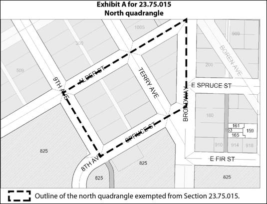
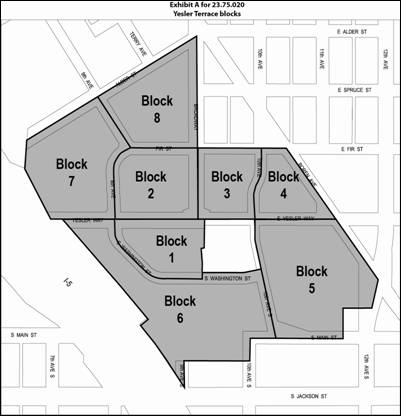
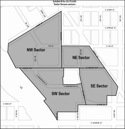
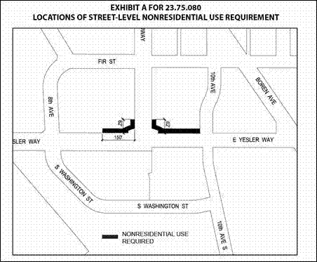
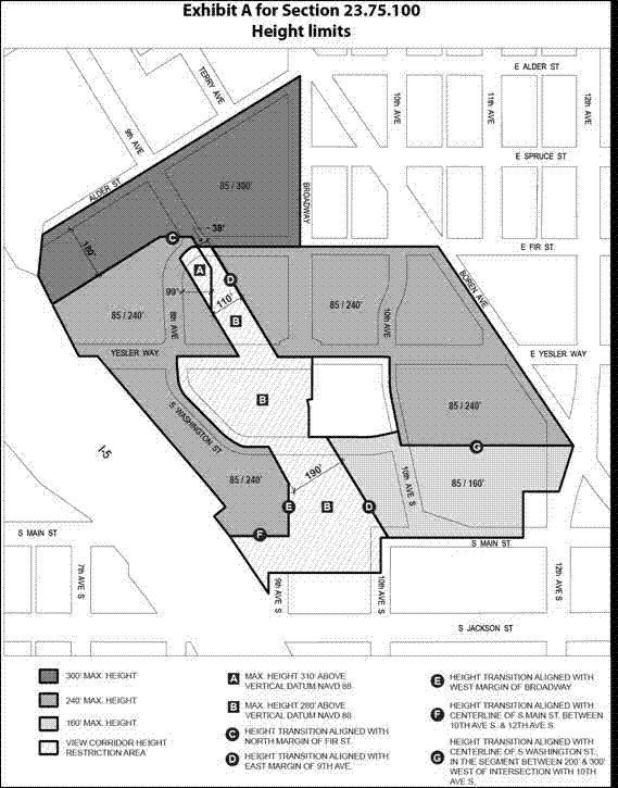
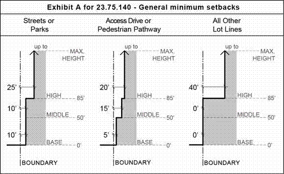
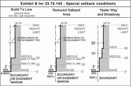
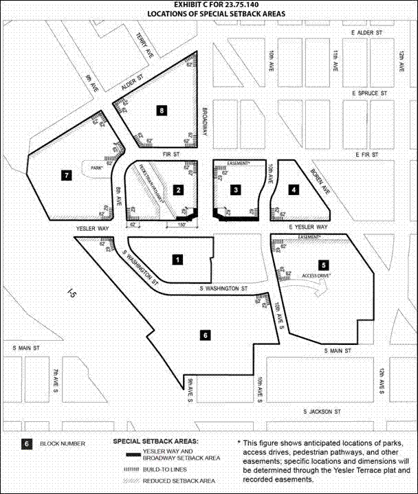
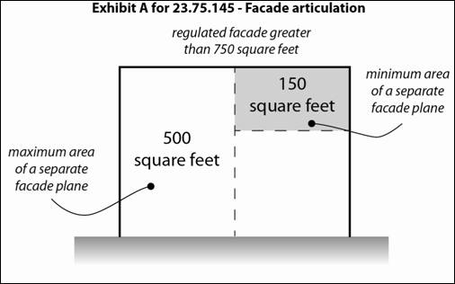
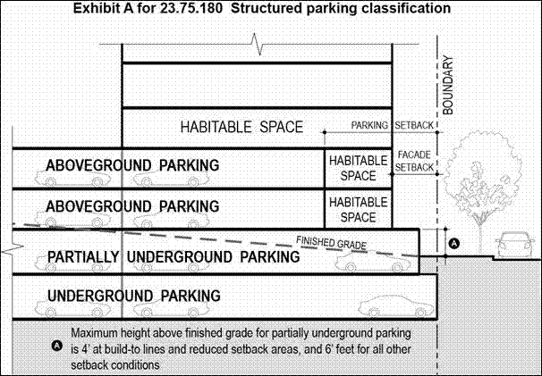
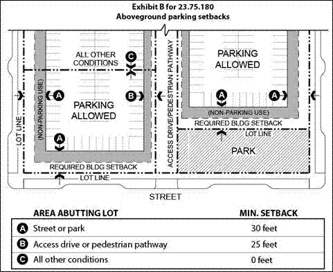
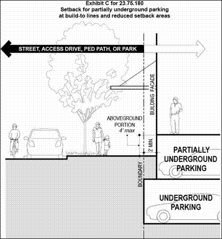

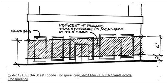 ***
***
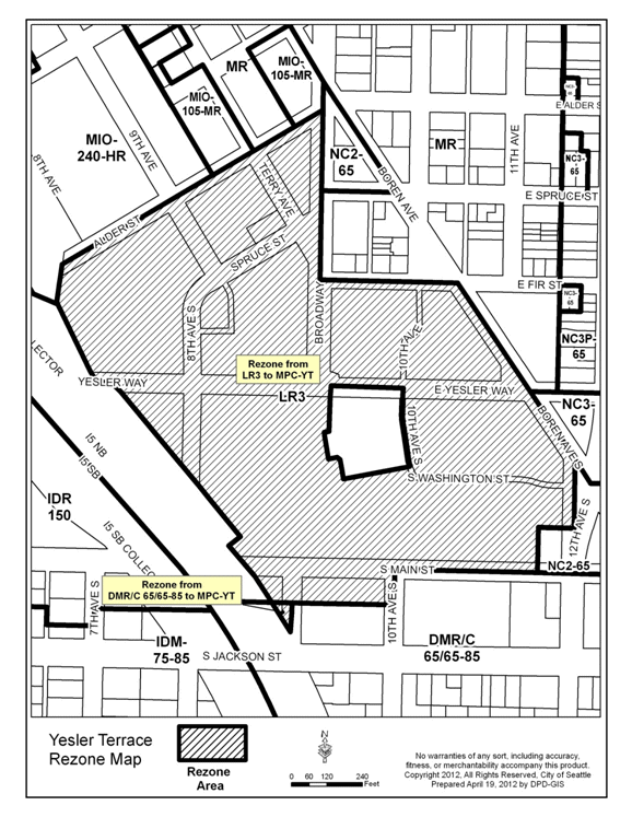
Attachments |
|---|
![[TOP]](/netaicon/toppg.gif)