

![[HOME]](/netaicon/homeicon.gif)
![[SEARCH]](/netaicon/srchpage.gif)

![[CURR_LIST]](/netaicon/curlist.gif)


![[BOTTOM]](/netaicon/bottom.gif)
![[HELP]](/netaicon/help.gif)
Seattle City Council Bills and Ordinances
Information modified on April 18, 2000; retrieved on April 25, 2024 7:21 PM
Ordinance 119973
Introduced as Council Bill 113164
Title | |
|---|---|
| AN ORDINANCE relating to comprehensive planning, amending the Seattle Comprehensive Plan to incorporate portions of the Greater Duwamish Manufacturing/Industrial Center Neighborhood Plan and to revise and add related policies for industrial areas; and amending the Official Land Use Map, Title 23 of the Seattle Municipal Code, to reflect the boundaries of the Duwamish Manufacturing/Industrial Center. | |
Description and Background | |
|---|---|
| Current Status: | Passed |
| Index Terms: | NEIGHBORHOOD-PLANS, COMPREHENSIVE-PLAN, DUWAMISH, INDUSTRIAL-DISTRICT |
| References: | Amending: Ord 117221; Related: Res 28966 |
Legislative History | |
|---|---|
| Sponsor: | CONLIN |
| Date Introduced: | April 17, 2000 |
| Committee Referral: | Neighborhoods, Sustainability and Community Development |
| City Council Action Date: | June 12, 2000 |
| City Council Action: | Passed |
| City Council Vote: | 9-0 |
| Date Delivered to Mayor: | June 13, 2000 |
|
Date Signed by Mayor: (About the signature date) | June 16, 2000 |
| Date Filed with Clerk: | June 16, 2000 |
Text | |
|---|---|
|
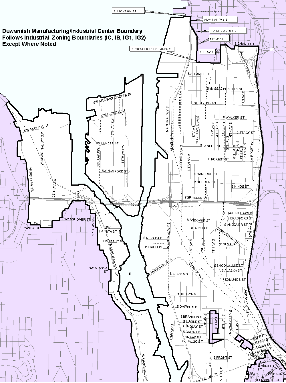
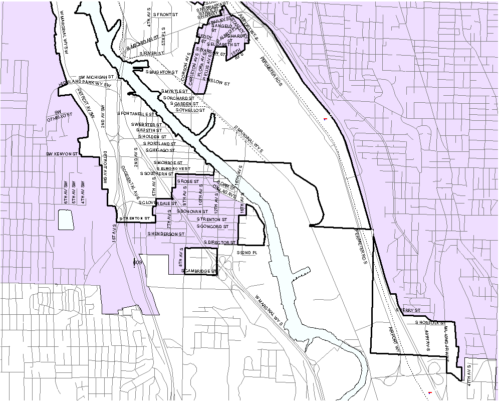
ORDINANCE __________________ AN ORDINANCE relating to comprehensive planning; amending the Seattle Comprehensive Plan to incorporate portions of the Greater Duwamish Manufacturing/Industrial Center Neighborhood Plan and to revise and add related policies for industrial areas, and amending the Official Land Use Map, Title 23 of the Seattle Municipal Code, to reflect the boundaries of the Duwamish Manufacturing/Industrial Center. WHEREAS, on July 25, 1994, by Ordinance 117221, the City Council adopted the Seattle Comprehensive Plan, which includes a neighborhood planning element; and WHEREAS, City Council Resolution 28966, adopted August 1, 1994, established a Neighborhood Planning Program for the City of Seattle; and WHEREAS, a coalition of North Duwamish manufacturing and industrial stakeholders came together to form the North Duwamish Organizing Committee in the Winter of 1996 for the purpose of preparing a Manufacturing and Industrial Center Plan as provided for in the City of Seattle Comprehensive Plan; and WHEREAS, the North Duwamish Organizing Committee, and later the Greater Duwamish Planning Committee, convened biweekly and monthly meetings open to the public and regularly attended by ten to fifteen citizens throughout the next four years; and WHEREAS, the North Duwamish Organizing Committee conducted an extensive Phase I outreach process featuring community events, surveys, focus groups, presentations, newsletters and other mailings, all of which led to a generally recognized vision for the North Duwamish industrial area as "a vital economic and transportation crossroads of regional significance" and part of the greater Duwamish Manufacturing/Industrial Center; and WHEREAS, this outreach process also created a list of priority planning topics and led to the selection of members for an expanded planning committee to lead Phase II planning for the Duwamish Manufacturing/Industrial Center; and WHEREAS, subcommittees were formed and consultants were hired to study and prepare analyses and recommendations on the issues of jobs and economics, land use, transportation, utilities, environmental remediation, and public safety; and WHEREAS, a final plan incorporating six Key Strategies was reviewed and approved by the Greater Duwamish Planning Committee and validated by the community in response to a community-wide mailer and validation event; and WHEREAS, the overall vision of the Greater Duwamish Manufacturing and Industrial Center Plan is consistent with the goals and policies of Seattle's Comprehensive Plan; NOW THEREFORE, BE IT ORDAINED BY THE CITY OF SEATTLE AS FOLLOWS: Section 1. The Seattle Comprehensive Plan as adopted by Ordinance 117221 and subsequently amended, is hereby amended as follows: A. The Table of Contents of the Neighborhood Plans volume of the Comprehensive Plan is hereby amended to add the Duwamish Manufacturing/Industrial Center, as shown in Attachment 1. B. The Greater Duwamish Manufacturing/Industrial Center Neighborhood Plan goals and policies, as shown in Attachment 2 to this Ordinance, are hereby incorporated into the Neighborhood Plans Volume of the Comprehensive Plan. C. The Land Use Element of the Comprehensive Plan is hereby amended as shown in Attachment 3 to this Ordinance to amend the description of industrial areas (Policy L115) and add a new policy L115a relating to residential uses in industrial areas. D. The capital facilities and utilities inventory and analysis and transportation analysis shown in Attachment 4 to this Ordinance are hereby incorporated into the Neighborhood Plans Volume, Duwamish Manufacturing/Industrial Center section, of the Comprehensive Plan. A new Land Use Figure, containing a large scale map of the Duwamish Manufacturing/Industrial Center is hereby added to the Land Use Element, as shown in Attachment 5 to this ordinance. Section 2. The amendments contained in Section 1 of this ordinance constitute an adopted neighborhood plan. Section 3. The Official Land Use Map, Section 23.32.016, Seattle Municipal Code, is amended to reflect the boundaries of the Duwamish Manufacturing/Industrial Center as depicted on Attachment 5 to this Ordinance. Section 4. The City Council finds that the amendments established by this ordinance are consistent with the Growth Management Act, and will protect and promote the health, safety and welfare of the general public. Section 5. This ordinance shall take effect and be in force thirty (30) days from and after its approval by the Mayor, but if not approved and returned by the Mayor within ten (10) days after presentation, it shall take effect as provided by Municipal Code Section 1.04.020. Passed by the City Council the ________ day of __________________, 2000, and signed by me in open session in authentication of its passage this _____ day of _______________, 2000 ___________________________________ President of the City Council Approved by me this _____ day of _______________, 2000. ___________________________________ Paul Schell, Mayor Filed by me this _____ day of _______________, 20____. ___________________________________ City Clerk (SEAL) LIST OF ATTACHMENTS ATTACHMENT 1 AMENDMENTS TO THE CITY OF SEATTLE COMPREHENSIVE PLAN TABLE OF CONTENTS ATTACHMENT 2 DUWAMISH MANUFACTURING/INDUSTRIAL CENTER GOALS AND POLICIES ATTACHMENT 3 AMENDMENTS TO THE COMPREHENSIVE PLAN LAND USE ELEMENT ATTACHMENT 4 DUWAMISH MANUFACTURING/INDUSTRIAL CENTER CAPITAL FACILITIES AND UTILITIES INVENTORY AND ANALYSIS, AND DUWAMISH MANUFACTURING/INDUSTRIAL CENTER TRANSPORTATION ANALYSIS ATTACHMENT 5 COMPREHENSIVE PLAN AND OFFICIAL LAND USE MAP AMENDMENTS Map of north portion Map of south portion JK:LRW:lrw March 24, 2000 (Ver. 1) ATTACHMENT 1 THE CITY OF SEATTLE COMPREHENSIVE PLAN NEIGHBORHOOD PLANS Table of Contents ***Duwamish Manufacturing/Industrial Center *** ATTACHMENT 2 DUWAMISH MANUFACTURING/INDUSTRIAL CENTER GOALS AND POLICIES Jobs and Economics G1: The Duwamish Manufacturing/Industrial Center remains economically vital. P1: Recognize the significant contribution of the industries and businesses in the Duwamish Manufacturing/Industrial Center in terms of the jobs they create, and the export and tax revenues they generate. P2: Strive to retain existing businesses and promote their viability and growth, with particular emphasis on small businesses. P3: Encourage new industrial businesses that offer family-wage jobs to locate in the area. P4: Encourage site assembly that will permit expansion or new development of industrial uses. P5: Limit the location or expansion of non-industrial uses, in the Duwamish Manufacturing/Industrial Center. G2: Public infrastructure adequate to serve business operations in the Duwamish Manufacturing/Industrial Center is provided. G3: Land in the Duwamish Manufacturing/Industrial Center is maintained for industrial uses including the manufacture, assembly, storage, repair, distribution, research about or development of tangible materials and advanced technologies; as well as transportation, utilities and commercial fishing activities.. P6: Strive to separate areas that emphasize industrial activities from those that attract the general public. G4: The City regulatory environment facilitates location and expansion of industrial businesses in the Duwamish Manufacturing/Industrial Center. P7: Continue to promote timeliness, consistency, coordination and predictability in the permitting process. Land Use G5: Land in the Duwamish Manufacturing/Industrial Center is sufficient to allow an increase in the number of family-wage industrial jobs that can be filled by workers with diverse levels of education and experience. P8: Strive to protect the limited and non-renewable regional resource of industrial, particularly waterfront industrial, land from encroachment by non-industrial uses. P9: Distinguish between the industrial zones in the Duwamish Manufacturing/Industrial Center by the amount and types of uses permitted in them. P10: If industrial land south of South Park is annexed to the City, include much of it in the Duwamish Manufacturing/Industrial Center, with appropriate land use controls to encourage industrial uses and discourage non-industrial uses. G6: The Duwamish waterway continues as a working industrial waterfront that retains and expands in value as a vital resource providing family-wage jobs and trade revenue for the City, region and state. P11: Strive to maintain sufficient capacity in the shoreline areas for anticipated water-dependent industrial uses. P12 : Seek to preserve the Duwamish Waterway's ability to function as the City's gateway to the Pacific and to provide adequate nearby land for warehousing and distribution that serve the shipping industry. P13: Especially along the waterway, discourage conversion of industrial land to non-industrial uses . P14: Maintain shoreside freight access to and from the waterway. P15: Strive to increase the trade revenues generated by Seattle's water-dependent industries. P16: Consider a variety of strategies, including possible financial incentives, to retain and attract marine businesses. G7: The City and other government bodies recognize the limited industrial land resource and the high demand for that resource by private industrial businesses within the Duwamish Manufacturing/Industrial Center when considering the siting of public uses there. P17: Seek to identify and minimize the impacts of non-industrial public uses on the industrial environment of the Manufacturing/Industrial Center by * encouraging public uses that, while permitted in industrial zones, are also allowed in other zones, to locate in such other zones; and * permitting public uses not generally permitted in industrial zones, or not meeting development standards for industrial zones, to locate in industrial zones only under limited circumstances to be specified by the City Council when adopting regulations allowing for such uses. P18: Encourage other jurisdictions to: 1) avoid locating nonindustrial uses in the Duwamish Manufacturing/Industrial Center 2) consolidate public facilities to minimize the amount of land consumed by the public sector and 3) pursue joint operations and co-location so that facilities can serve more than one jurisdiction. P19: Encourage public agencies, including City agencies, to explore ways of making property available for private industrial uses when disposing of property in the Duwamish Manufacturing/Industrial Center. G8: The Duwamish Manufacturing/Industrial Center remains a Manufacturing/Industrial Center promoting the growth of industrial jobs and businesses and strictly limiting incompatible commercial and residential activities. P20: Prohibit certain commercial uses and regulate the location and size of other commercial uses in the Manufacturing/Industrial Center. P21: Seek to integrate stadium and stadium-related uses into the Duwamish Manufacturing/Industrial Center by creating an overlay district limited to the area near the stadiums that discourages encroachment on nearby industrial uses, creates a pedestrian connection from the stadiums north to downtown, and creates a streetscape compatible with Pioneer Square. Transportation G9: A high level of general mobility and access is attained within the Duwamish Manufacturing/Industrial Center. P22: Strive to enhance access throughout the Duwamish Manufacturing/Industrial Center by means such as signal coordination, roadway channelization, grade separation and pavement rehabilitation. P23: Encourage use of Airport Way as an alternate route for commute trips that might otherwise use 1st and 4th Avenues. P24: Strive to maintain the existing capacity on roadways and bridges and encourage use of under-used facilities. P25: Encourage maintenance of a connection across the Duwamish River that provides access to the South Park area while allowing the river to continue serving marine traffic. P26: Strive to maintain arterial/rail crossings until those crossings can be replaced with grade separations. P27: Recognize and strive to address the cumulative traffic effects that transportation and development projects in and near the Duwamish Manufacturing/Industrial Center can have on freight mobility. G10: The transportation network in the Duwamish Manufacturing/Industrial Center makes appropriate connections and minimizes conflicts between different travel modes. P28: Pursue opportunities and develop partnerships to provide grade separations between rail and auto/truck traffic along key east-west routes for enhanced speed and reliability while maintaining safety for both travel modes. P29: Encourage the design of bicycle and pedestrian facilities in the Duwamish Manufacturing/Industrial Center that minimize conflicts between motorized and non-motorized traffic and promote both traffic flow and safety. P30: Strive to maintain waterborne and roadway access to seaport facilities. P31: Strive to maintain access for air cargo to the King County International Airport. G12: The transportation network in the Duwamish Manufacturing/Industrial Center emphasizes the mobility of freight and goods. P32: Strive to facilitate east-west freight movement in the Duwamish Manufacturing/Industrial Center, particularly through the Royal Brougham, Spokane Street and Michigan Street corridors. P33: Strive to maintain efficient freight movement along designated truck routes in the Duwamish Manufacturing/Industrial Center. P34: Strive to maintain reasonable access to regional transportation facilities for goods distribution from all areas of the Duwamish Manufacturing/Industrial Center. P35: Recognize the importance of inter-modal connections for the movement of freight between the state highway system, rail yards, barge terminals, Port terminals, airports and warehouse/distribution centers. P36: Strive to minimize disruptions to freight mobility caused by construction (including construction of transportation facilities) in the Duwamish Manufacturing/Industrial Center. P37: In setting priorities for roadway repairs in the Manufacturing/Industrial Center, consider the importance of those facilities to freight mobility. G13: Rail service in the Duwamish Manufacturing/Industrial Center remains safe and efficient. P38: Consider setting speed limits for trains high enough to limit the length of time trains block streets at grade crossings. P39: Encourage railroad operations in which switching and signals enhance the speed and reliability for passenger and freight trains. G14: Well-maintained streets and facilities serve all the properties in the Duwamish Manufacturing/Industrial Center. P40: Encourage a working relationship between the City and property and business owners in the area to identify possible funding sources for non-arterial road and drainage improvements. G15: Sufficient transportation infrastructure, particularly in the northern portion of the Duwamish Manufacturing/Industrial Center, minimizes the transportation impacts of special events on industrial users. P41: Encourage the efficient use of transit opportunities, including the E-3 busway, to expedite the movement of event patrons in and out of the Duwamish Manufacturing/Industrial Center. P42: Encourage the management of event parking in ways that minimize the impacts on congestion in the Duwamish Manufacturing/Industrial Center. P43: Strive to maintain parking that serves local businesses during special events. P44: Strive to maintain sufficient rail spurs to accommodate existing and potential future business needs in the Duwamish Manufacturing/Industrial Center. G16: The public transit system provides employee access to the Duwamish Manufacturing/Industrial Center while minimizing impacts on freight mobility. P45: Encourage employees in the Duwamish Manufacturing/Industrial Center to use public transit for commuting to work through means such as employer subsidized bus passes and enhanced transit service. P46: Seek to minimize impacts on freight mobility in the design of new or expanded transit facilities in the Duwamish Manufacturing/Industrial Center. Utilities G17: The network of utilities is sufficient to meet the needs of businesses in the area. P47: Strive to maintain affordable rates for City-operated utilities serving the Duwamish Manufacturing/Industrial Center. P48: Strive to provide stormwater facilities that help increase pavement durability. Environmental Remediation G18: Sufficient incentives exist in the industrial area so that the private sector can remedy environmental contamination and contribute to the expansion of the industrial job base. Public Safety G19: The community makes use of crime prevention resources in the Duwamish Manufacturing/Industrial Center and adjacent residential communities to control crime and increase the sense of security in the area. P49: Recognize crime prevention as a significant contributor to economic vitality in the Duwamish Manufacturing/Industrial Center and to the quality of life in the surrounding residential communities. G20: Public investments contribute to a sense of community identity and enhance public safety. P50: Encourage the use of community policing techniques to increase personal safety. P51: Consider techniques such as neighborhood identification and wayfinding signs to increase pride in the community and to facilitate navigation through the Duwamish Manufacturing/Industrial Center. ATTACHMENT 3 AMENDMENTS TO THE COMPREHENSIVE PLAN LAND USE ELEMENT 1. Replace Policy L115 with the following policy:
L115: Include among appropriate activities manufacturing uses, advanced technology industries and a wide range of industrialrelated commercial functions, such as warehouse and distribution activities. Of highest priority are high value-added, high-wage
industrial activities. 2. Add a new Policy L115a as follows: The City recognizes that some commercial and residential uses may be incompatible with industrial uses in industrial areas, which may cause air, noise, dust and light impacts; and the City will favor the industrial activities over non-industrial uses in these areas, as long as the industrial uses operate within prescribed limits. ATTACHMENT 4 DUWAMISH MANUFACTURING/INDUSTRIAL CENTER FACILITIES AND UTILITIES INVENTORIES AND ANALYSIS AND DUWAMISH MANUFACTURING/ INDUSTRIAL CENTER TRANSPORTATION ANALYSIS Table 1 Inventory for Capital Facilities and Utilities Serving Duwamish Manufacturing/Industrial Center Facility Type Name Location Capacity Information Sources1/Comments Fire Station2 SFD 5 SFD 10 SFD 11 SFD 14 SFD 26 SFD 27 SFD 29 SFD 36 925 Alaska Way 301 Second Ave. S 1514 SW Holden 3224 Fourth Ave. S 800 S Cloverdale St. 1000 S Myrtle St. 9645 Renton Ave. S 3600 23rd Ave. SW Combined capacity of these stations includes: 8 Engine Companies, 2 Ladder Companies, Battalion 1 & 7, Fireboat, 3 Aid Units, HazMat Van, Foam, Marine Response Van, Heavy Rescue Equipment, Confine Space Equipment, Mobile Air Supply Seattle Fire Department Police Station South Precinct 3001 S. Myrtle St. 31.87 sq. mi. service area, 1990 population 155,777 Seattle Police Department Patrol units are allocated around-the-clock based on calls for service. Location and size of facilities are not critical to service provision. Parks3 Beacon Place S Dearborn St./11th Ave. S .25 ac Open Spaces, Parks and Facilities Inventory, Seattle Department of Parks and Recreation, August 1989 Beacon Hill Playfield 1902 13th Ave. S 3.0 ac: basketball hoops, play area, soccer/football field, softball/baseball field, tennis courts, wading pool Urban Villages Open Space Analyses, Office of Management and Planning, Department of Parks and Recreation, July 1999, Strategic Planning Office Benefit Playground 9320 38th Ave. S 2.2 ac: basketball hoops, play area, picnic tables, trails Katie Black's Garden 12th Ave. S. & S. Atlantic St. 0.6 ac Cleveland Playfield S Lucile St. & 13th Ave. S 2.6 ac: football/soccer field, tennis courts Duwamish Waterway Park 10th Ave. S & S Elmgrove St. 0.83 ac: Lawn, waterway access, picnic area Georgetown Playfield Corson Ave. S and S. Homer St. 5.4 ac: Shelterhouse, wading pool, play area, handball, one tennis court, two floodlit softball fields or one football/soccer field. International Children'sPark 700 S Lane St. 0.2 ac Jefferson Park 4165 16th Ave S 52.4 ac: golf, lawn bowling, basketball hoops, children's play area, athletic fields Maplewood Playfield 4801 Corson Ave. S 15.5 ac: Basketball hoops, play area, soccer/football fields, softball/baseball fields, picnic tables, restrooms, trail Puget Park 1900 SW Dawson St. 20.1 ac: Trails, paths, woods, creek Riverview Playfield 7226 12th Ave. SW 42.3 ac: basketball hoops, play area, soccer/football fields, softball/baseball fields, tennis courts, woods Dr. Jose Rizal Park 1008 12th Ave. S 8.4 ac: play area, picnic tables, woods South Park Meadow 9100 8th Ave S 1.0 ac South Park Playground 8th Ave. S & S Sullivan St. 5.5 ac: 2 tennis courts, 2 softball fields or 1 football/soccer field, wading pool, play area Westcrest Park 9000 8th Ave. SW 81.1 ac: picnic tables, woods, trails, views Other 12th Ave. S. Viewpoint 12th Ave. SW and SW Othello St. 1.1 ac Duwamish Head Greenbelts: Harbor Ave SW/ Fairmount Ave SW 56 ac East Duwamish Greenbelt: Beacon Ave. S., S. Chicago St., S. Spokane St. 75.61 ac Longfellow Creek Greenspace: North SW Graham St/Delridge Way SW 34 ac: Creek, woods, trails South Park Community Center 8319 8th Ave. S >10,000 sq. ft: Gym, meeting room, craft rooms, kitchen, kids room, game room West Duwamish Greenbelt: Highland Park Way SW/ West Marginal 158.33 ac Electrical Power South Substation Duwamish Substation 3839 4th Ave S 10000 Marginal Way S not in city limits 288 Megawatts 294 Megawatts Seattle City Light, October 1996 This village is located in City Light's Southwest forecast area, which has a total capacity 427 of megawatts. Water This village is located in the 316 pressure zone. Water is supplied from the Cedar River supply. Storage is provided by the Beacon Reservoir (Beacon Ave. S & S Spokane St.) and Trenton Standpipes. See map for system locations. (Utilities Figure A4, Comprehensive Plan Appendix). Beacon Reservoir: 61 million gallons Supply mains were constructed primarily before 1949. Pipes are primarily of cast iron. Portions of the system in the Southwest Harbor area were constructed after 1979. It is usual for facilities in industrial areas to be sized to accommodate the larger needs of industrial water users. Seattle Water Department, October-November, 1996 In this pressure zone, elevations range from 10-60 feet above sea level; static water pressure ranges from 111-133 pounds per square inch.4 Minimum pressure in this area is considered very good. Soils could be subject to liquefaction in seismic events. Drainage & Wastewater About half of this center is served by a partially separated system and half by a combined system, with small areas in the southern portion of the Center served by a separated system with a ditch & culvert stormwater system. The southeastern portion of this Center is located in the Norfolk Drainage Basin, which covers about 672 acres. The existing drainage system flows through two small natural wetland areas and discharges to the Norfolk Outfall into the Duwamish River. The southwestern portion of this Center is located in the South Park basin, which has two areas with distinct characteristics: 1. west basin steep and moderately wooded; and 2. east basin very flat and highly developed. No single, well-defined drainage corridor exists for this basin. Drainage occurs through several small corridors which eventually discharge to the Duwamish River. Runoff from the east drainage basin either flows overland to the Duwamish River at various points or enters the sewer system. See map for system locations. (Utilities Figure A5, Comprehensive Plan Appendix). With Partially Separated systems, about 15% of the stormwater enters the sewer system, with the remaining 85% diverted to the storm drain system. Capacity of the Partially Separated systems in this area is considered adequate. With Combined systems, existing sewage flows constitute about 5% of pipe capacity, with the remainder for stormwater flows. Capacity of the combined systems in this area is considered adequate. In areas with Separated systems and storm drains, systems are sized for full zoned development and capacity is considered adequate. In areas with Separated systems and ditch & culvert drainage systems, sewage systems are sized for full zoned development and capacity is considered adequate. Drainage systems in these areas occasionally lack adequate capacity. CIP projects to provide additional capacity are part of a 15 year program in the City's adopted Comprehensive Drainage Plan. Occasionally, sewer rehabilitation projects in the 6-year Capital Improvement Program are completed which sometimes enhance the system capacity in an area. Seattle Drainage and Wastewater Utility, November 1996 Combined Sanitary/Stormwater System: A system where all sanitary and storm wastewater is carried through the system in one sewer pipe. Partial Separation System: A system where the water from street and major parking lot drainage is collected and transferred in one pipe or ditch and culvert system, and the other surface wastewater such as that from roof drains is carried with the sanitary sewer in a sewer pipe. Separate Sanitary and Stormwater System: A system where the sanitary wastes are transferred in one pipe, and roof and street runoff is carried in a separate pipe or through a ditch & culvert system. Table 2 Expected 6-yr. Job Growth: 4,100 Capital Facilities and Utilities Analysis Expected 20-yr Job Growth: 10,860 Duwamish Manufacturing/Industrial Center Land Area: 4,689 Acres Facilities needed to accommodate: Facility Type 6-year growth 20-year growth Analysis Fire None None The Fire Stations that serve this M/IC have the following response times Station Emergency medical calls Fire calls SFD 5 2.63 minutes 3.61 minutes SFD 10 2.99 minutes 3.71 minutes SFD 11 4.15 minutes 4.71 minutes SFD 14 3.91 minutes 4.93 minutes SFD 27 5.16 minutes 4.11 minutes SFD 26 3.51 minutes 4.99 minutes SFD 29 3.77 minutes 4.14 minutes SFD 36 4.27 minutes 5.01 minutes Except for station #36, all response times meet industry standards and are expected to for the next six years. Station #36 is located very close to the center, therefore response times to calls for service within the center should be well below the station average and are expected to remain so for the next six years. Police None Additional space may be required. Patrol units are allocated around-the-clock based on calls for service. Location and size of facilities are not critical to service provision. The new West Precinct facilities nearing completion will accommodate this precinct's facility needs. Minor facility modifications for other precincts will occur as needed and funded. Electricity None A 4th transformer and switchgear bus-section will be added to the Duwamish Substation to increase capacity in this forecast area Electrical demand from this M/IC is estimated to increase by 7.8 annual average megawatts and 12.6 megawatts in a peak hour in 6 years. This village is located in City Light's Southwest forecast area. In 6 years, capacity in this forecast area will be 427 megawatts, and demand is expected to be 398 megawatts. In 20 years, capacity in this forecast area will be 547 megawatts, and demand is expected to be 471 megawatts. In both years, capacity is more than adequate to meet demand. Water None None Current peak day demand estimate: 13.0 million gallons per day (mgd). Peak day demand estimate in 6 yrs: 13.9 mgd or 6% increase. Peak day demand estimate in 20 years: 15.2 mgd or 17% increase. The supply and distribution network is in generally good order and appears to be adequately sized to accommodate demand through 2002. It is usual for facilities in industrial areas to be sized to accommodate the larger needs of industrial water users. Current job projections indicate that increases in peak day water use could be met by existing networks. As individual redevelopments proceed, the infrastructure will need to be reviewed to eliminate any localized problems. Drainage and Wastewater No new facilities are expected because of new growth. The Drainage Control Ordinance requires on-site detention of stormwater runoff associated with new development or significant redevelopment. Limiting the rate of stormwater runoff from these sites more than offsets the increases in sewage flow from increased population density. The net effect of new development/redevelopment in this area will be a decrease in the peak rates of flow during storm events. Depending on the concentration of actual development, it is possible that isolated sewer capacity improvements would be needed. For Partially separated systems, wastes from growth will constitute small incremental flows that are not likely to exceed capacity. With Combined systems, existing sewage flows constitute only about 5% of pipe capacity, and wastes from growth will constitute small incremental flows that are not likely to exceed capacity. On-site detention requirements for new growth will address the adequacy of the drainage systems for these areas. In areas with Separated systems and ditch & culvert stormwater systems, sewage systems are sized for full zoned development; capacity is considered adequate to serve growth. Drainage system improvements in the Comprehensive Drainage Plan and on-site detention requirements for new growth will address the adequacy of the drainage system for this area. See the Norfolk Study and the South Park and Norfolk Basin Plans in the 1995 Comprehensive Drainage Plan Update, Seattle Drainage and Wastewater Utility. Table 3 Transportation Analysis5 for Duwamish Manufacturing/Industrial Center Arterial Existing V/C Forecast 2010 Arterial Segment Class Direction ratio V/C ratio SR 99/1st Ave S West Marginal Way S - Principal Northbound 1.6 0.6 Bridge S Michigan St Ramps Southbound 1.3 0.7 SR 99/1st Ave S S Michigan St Ramps - Principal Northbound 0.6 1.0 Bridge East Marginal Way S Southbound 1.0 1.2 S Michigan St Ramps SR 99 - Principal Eastbound 0.6 0.8 from 1st Ave S Bridge East Marginal Way S Westbound 1.0 1.0 Alaskan Way Viaduct East Marginal Way S - Principal Northbound 1.0 1.1 1st Ave S Ramps Southbound 1.1 1.2 East Marginal Way S City Limit - Principal Northbound 1.1 1.1 Ellis Ave S Southbound 0.8 1.1 East Marginal Way S Ellis Ave S - Principal Northbound 1.1 1.1 S Michigan St Southbound 0.6 0.9 East Marginal Way S S Michigan St - Principal Northbound 0.7 0.9 Duwamish Ave S Southbound 0.7 0.9 East Marginal Way S/ Duwamish Ave S - Principal Northbound 0.5 0.7 Alaskan Way S Royal Brougham Way Southbound 0.6 0.8 Alaskan Way S Royal Brougham Way - Principal Northbound 0.7 0.8 S Jackson St Southbound 0.7 1.0 1st Ave S East Marginal Way S - Principal Northbound 0.5 0.6 S Spokane St Southbound 0.7 1.0 1st Ave S S Spokane St - Principal Northbound 1.0 1.2 Royal Brougham Way Southbound 1.0 1.3 1st Ave S Royal Brougham Way - Principal Northbound 0.9 1.0 Alaskan Way Via Ramp Southbound 0.7 1.0 4th Ave S East Marginal Way S - Principal Northbound 0.6 0.7 S Spokane St Southbound 0.6 0.8 4th Ave S S Spokane St - Principal Northbound 0.8 0.9 Royal Brougham Way Southbound 0.7 1.0 Airport Way S S Hardy St - Principal Northbound 0.4 0.5 S Spokane St Southbound 0.8 1.0 Airport Way S S Spokane St - Principal Northbound 0.4 0.5 Royal Brougham Way Southbound 0.7 1.0 Airport Way S Royal Brougham Way - Principal Northbound 0.5 0.6 4th Ave S Southbound 0.3 0.4 6th Ave S S Industrial Way - Minor Northbound 0.4 0.4 S Spokane St Southbound 0.1 0.1 6th Ave S S Spokane St - Minor Northbound 0.6 0.6 Airport Way s Southbound 0.8 0.9 West Marginal Way S 14th Ave S - Principal Northbound 0.5 0.6 /SR 99 SR 99/SR 509 Southbound 0.5 0.7 West Marginal Way SR 99/SR 509 - Principal Northbound 0.6 0.7 SW Chelan Ave SW Southbound 0.5 1.1 SW Avalon Way SW Genesee St - Minor Northbound 0.3 0.3 SW Spokane St Southbound 0.4 0.5 Harbor Ave SW SW Spokane St - Minor Northbound 0.5 0.6 SW Florida St Southbound 0.4 0.4 Delridge Way SW SW Andover St - Principal Northbound 0.5 0.5 SW Spokane St Southbound 0.7 0.8 West Seattle Fwy Harbor Ave SW - Principal Eastbound 0.6 0.6 Upper Spokane Alaskan Way Viaduct Westbound 1.1 1.1 Spokane St. Viaduct Alaskan Way Viaduct - Principal Eastbound 0.8 0.9 Upper Spokane I-5 Westbound 0.9 1.0 SW Spokane St Harbor Ave SW - Principal Eastbound 0.6 0.6 Chelan Ave SW Westbound 0.6 0.6 SW Spokane St Chelan Ave SW - Principal Eastbound 0.2 0.3 SW Manning St Westbound 0.4 0.6 SW Spokane St SW Manning St - Principal Eastbound 0.9 1.1 E Marginal Way S Westbound 0.7 0.8 S Spokane St E Marginal Way S - Principal Eastbound 0.6 0.6 6th Ave S Westbound 0.4 0.5 Royal Brougham Way Alaskan Way S - Principal Eastbound 0.5 0.7 4th Ave S Westbound 0.5 0.6 Royal Brougham Way 4th Ave S - Principal Eastbound 0.4 0.5 Airport Way S Westbound 0.7 0.7 S Holgate St 1st Ave S - Minor Eastbound 0.4 0.5 4th Ave S Westbound 0.4 0.5 S Holgate St 4th Ave S - Minor Eastbound 0.6 0.7 I-5 Overcrossing Westbound 0.6 0.7 S Lander St 1st Ave S - Minor Eastbound 0.5 0.5 4th Ave S Westbound 0.4 0.5 S Lander St 4th Ave S - Minor Eastbound 0.4 0.5 Airport Way S Westbound 0.4 0.5 S Forest St 6th Ave S - Minor Eastbound 0.1 0.1 I-5 Off Ramp Westbound 0.3 0.4 S Industrial Way 4th Ave S - Minor Eastbound 0.2 0.3 Airport Way S Westbound 0.3 0.3 S Lucile St E Marginal Way S - Minor Eastbound 0.3 0.3 Airport Way S Westbound 0.3 0.3 S Michigan St E Marginal Way S - Principal Eastbound 0.9 0.9 Carleton Ave S Westbound 1.0 1.0 Corson Ave S E Marginal Way S - Minor Northbound 0.4 0.4 S Michigan St Southbound 0.4 0.4 Corson Ave S S Michigan St - Minor Northbound 0.3 0.3 Airport Way S Southbound 0.5 0.5 Ellis Ave S/S Albro Pl E Marginal Way S - Principal Northbound 0.4 0.4 Stanley Ave S Southbound 0.4 0.5 S Hardy St Airport Way S - Principal Eastbound 0.5 0.5 S Albro Pl Westbound 1.0 1.0 S Cloverdale St SR 509 - Principal Eastbound 0.4 0.4 14th Ave S Westbound 0.8 0.8 14th Ave S/16th Ave S W Marginal Way S - Principal Northbound 0.4 0.4 E Marginal Way S Southbound 0.7 0.9 The volume-to-capacity (V/C) ratio is an indicator of congestion. The table above shows existing V/C ratios and projections of V/C ratios for a typical evening peak hour in 2010 for all arterials in the Duwamish Manufacturing and Industrial Center. The existing V/C ratios are estimated from traffic counts collected in 1992 through 1995. Compare existing V/C ratios to the 2010 forecast to see the potential change over time. The V/C ratio can be used to identify areas where neighborhood or citywide transportation plans could encourage changes in travel behavior (e.g., mode, time of travel, destination) or improve operation of the street (e.g., by changing signal timing and the like). The capacity of a street is not a fixed number of vehicles that can never be exceeded. Rather, it is a relative measure of traffic flow. Arterial segments with a V/C ratio exceeding 1.0 now or possibly in the future might warrant attention in a neighborhood plan. High V/C ratios may be tolerable if the result is to shift people into other modes, or is a result of the development densities necessary for a vital urban village. Existing conditions: The V/C ratio on the First Avenue South Bridge is 1.6 northbound and 1.3 southbound. The westbound on-ramp from S. Michigan St. to the bridge has a V/C ratio of 1.0. East Marginal Way S. from the south city limit to S. Michigan St. has a V/C ratio of 1.1. The VC ratio on the westbound West Seattle Freeway west of Alaskan Way is 1.1. The Alaskan Way Viaduct also has a V/C ratio of 1.1 southbound between the 1st Ave. S. ramps and East Marginal Way S. The V/C ratio in the northbound direction on the viaduct is 1.0. Other streets in the manufacturing/industrial center with a V/C ratio of 1.0 include 1st Ave. S. between S. Spokane St. and Royal Brougham Way, S. Michigan St. between E Marginal Way S. and Carleton Ave. S., and S. Hardy St. between Airport Way S. and S. Albro Pl. The Alaskan Way Viaduct is a state highway (SR 99) with limited access starting at S. Spokane St. and continuing north through downtown Seattle along the waterfront. SR 99 continues south of the viaduct as East Marginal Way, across the First Avenue South Bridge, and then southeast toward I-5. SR 509 is a southerly extension of SR 99 south of the First Avenue South Bridge toward Burien and Sea-Tac. The City of Seattle and Washington State Department of Transportation are constructing a second span parallel to the First Avenue South Bridge (SR 99) that will increase capacity and improve safety. Other principal arterials in the manufacturing and industrial center include: 1st Ave. S., 4th Ave. S., Airport Way S., Alaskan Way S., East Marginal Way S., West Marginal Way S., S./S.W. Spokane St., Royal Brougham Way, S. Michigan St., Ellis Ave. S., S. Albro Pl, S. Hardy St., S. Cloverdale St., 14th Ave. S., and Delridge Way S.W. Transit Priority Network streets in the manufacturing and industrial center include: Alaskan Way Viaduct, East Marginal Way from the Alaskan Way Viaduct to 1st Ave. S., First Avenue South Bridge, SR 509, 4th Ave. S., S. Michigan St., S. Spokane St. Viaduct, West Seattle Freeway, and Delridge Way S.W. Future conditions: As a result of the new construction, the V/C ratio on the First Avenue South Bridge is projected to improve to below 0.8. North of the Michigan St. ramps, the capacity was assumed to remain unchanged, so the increase in traffic volumes (from existing) would result in V/C ratios near 1.2 southbound on this section. The V/C ratio on the northbound off-ramp to Michigan St./East Marginal Way is projected to increase to 1.1. The V/C ratio on the Alaskan Way Viaduct is projected to increase to 1.1 northbound and 1.2 southbound. East Marginal Way S. would see an increase to 1.1 in the southbound direction. The V/C ratio on 1st Ave. S. between S. Spokane St. and Royal Brougham Way is projected to increase to 1.2 northbound and 1.3 southbound. North of Royal Brougham Way (both directions) and south of S. Spokane St. (southbound), the V/C ratio would increase to 1.0. The V/C ratio is also projected to increase to 1.1 on southbound West Marginal Way S.W. and eastbound S.W. Spokane St. between Harbor Island and East Marginal Way S. In addition to those listed above, the V/C ratio is projected to increase to 1.0 on the following streets: Alaskan Way S. from S. Jackson St. to Royal Brougham Way, 4th Ave. S. from Royal Brougham Way to S. Spokane St., Airport Way S. from Royal Brougham Way to S. Hardy St., and the westbound Spokane St. Viaduct. 1 For an overview of City facilities, see Community Services and Facilities, Public Utilities Background Report, City of Seattle, Office of Management and Planning, 1990. 2 The nearest stations are listed; Fire and Emergency Medical Services are generally provided by the nearest station. In the case of larger fires, firefighting and medical resources are also dispatched from other stations. Aid units and fire engines are equipped to handle many medical emergencies; medic units are dispatched to serious medical emergencies. 3 Parks and Other Resources shown are inside the village or within 1/8 mile of the unadopted village boundary. 4 Minimum working pressure of 30 psi is the standard for new construction and 80 psi is the new standard for maximum pressure. Some areas of Seattle exceed the maximum and other areas have less than the minimum pressure. 5 The results of this analysis are not intended for measuring concurrency. Previous concurrency analyses contained in the Comprehensive Plan indicate that Level-of-Service standards will not be exceeded by the 20-year growth projected for this area (see Comprehensive Plan Transportation Element). |
|
Attachments |
|---|
![[TOP]](/netaicon/toppg.gif)