![[HOME]](/netaicon/homeicon.gif)
![[SEARCH]](/netaicon/srchpage.gif)

![[CURR_LIST]](/netaicon/curlist.gif)


![[BOTTOM]](/netaicon/bottom.gif)
![[HELP]](/netaicon/help.gif)
Seattle City Council Bills and Ordinances
Information modified on May 5, 2016; retrieved on August 4, 2025 2:48 PM
Ordinance 121961
Introduced as Council Bill 115417
Title | |
|---|---|
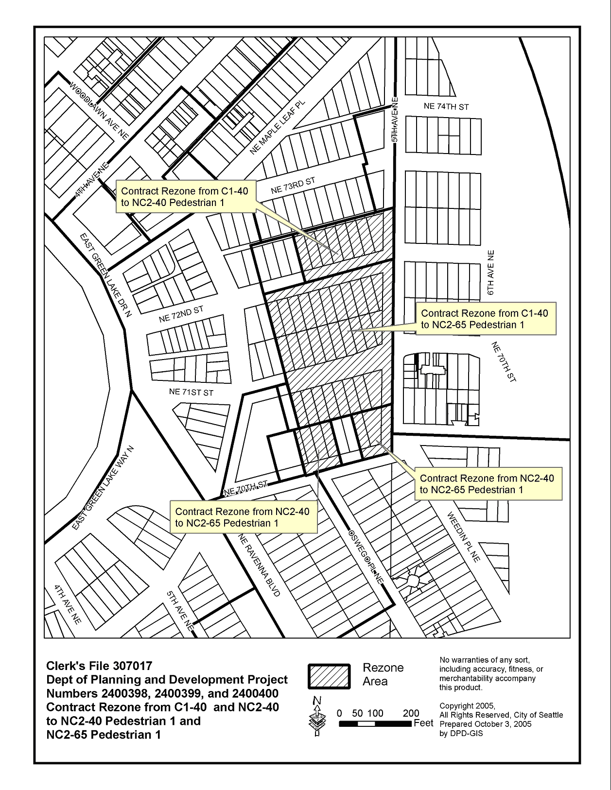
| AN ORDINANCE relating to land use and zoning; amending Chapter 23.32 of the Seattle Municipal Code at page 42 of the Official Land Use Map (Volume 6 of Plats, page 20, Records of King County) to rezone property located at 427 N.E. 72nd Street, 420 N.E. 72nd Street, and 466 N.E. 70th Street from Commercial 1 with a 40 foot height limit (C1 40) to Neighborhood Commercial 2 with a 40 foot height limit and Pedestrian 1 overlay (NC2 40 P1) and to Neighborhood Commercial 2 with a 65 foot height limit and Pedestrian 1 overlay (NC2 65 P1) and from Neighborhood Commercial 2 with a 40 foot height limit (NC2 40) to Neighborhood Commercial 2 with a 65 foot height limit and Pedestrian 1 overlay (NC2 65 P1) and accepting a Property Use and Development Agreement in connection therewith. (Petition of Lorig and Associates, C.F. 307017, Project Numbers 2400398, 2400399, and 240400.) | |
Description and Background | |
|---|---|
| Current Status: | Passed |
| Fiscal Note: | Fiscal Note to Council Bill No. 115417 |
| Index Terms: | REZONES, GREEN-LAKE, CONTRACT-REZONES |
| References: | Related: C.F. 307017 |
Legislative History | |
|---|---|
| Sponsor: | STEINBRUECK |
| Date Introduced: | October 10, 2005 |
| Committee Referral: | Urban Development and Planning |
| City Council Action Date: | October 17, 2005 |
| City Council Action: | Passed |
| City Council Vote: | 9-0 |
| Date Filed with Clerk: | October 17, 2005 |
| Signed Copy: | PDF scan of Ordinance No. 121961 |
Text | |
|---|---|
|
AN ORDINANCE relating to land use and zoning; amending Chapter 23.32 of the Seattle Municipal Code at page 42 of the Official Land Use Map (Volume 6 of Plats, page 20, Records of King County) to rezone property located at 427 N.E. 72nd Street, 420 N.E. 72nd Street, and 466 N.E. 70th Street from Commercial 1 with a 40 foot height limit (C1 40) to Neighborhood Commercial 2 with a 40 foot height limit and Pedestrian 1 overlay (NC2 40 P1) and to Neighborhood Commercial 2 with a 65 foot height limit and Pedestrian 1 overlay (NC2 65 P1) and from Neighborhood Commercial 2 with a 40 foot height limit (NC2 40) to Neighborhood Commercial 2 with a 65 foot height limit and Pedestrian 1 overlay (NC2 65 P1) and accepting a Property Use and Development Agreement in connection therewith. (Petition of Lorig and Associates, C.F. 307017, Project Numbers 2400398, 2400399, and 240400.) BE IT ORDAINED BY THE CITY OF SEATTLE AS FOLLOWS: Section 1. This Ordinance affects the following described property: THE SOUTHERLY 65 FEET OF LOTS 7 AND 8, BLOCK 34, WOODLAWN ADDITION TO GREEN LAKE ACCORDING TO THE PLAT THEREOF RECORDED IN VOLUME 6 OF PLATS, PAGE 20, IN KING COUNTY, WASHINGTON. LOTS 9 AND 10, BLOCK 34 OF WOODLAWN ADDITION TO GREEN LAKE, ACCORDING TO THE PLAT THEREOF RECORDED IN VOLUME 6 OF PLATS, PAGE 20, IN KING COUNTY, WASHINGTON. THE EAST 10 FEET OF LOT 7, BLOCK 33 AND ALL OF LOT 11, BLOCK 34 OF WOODLAWN ADDITION TO GREEN LAKE, ACCORDING TO THE PLAT THEREOF RECORDED IN VOLUME 6 OF PLATS, PAGE 20, IN KING COUNTY, WASHINGTON THE WEST 20 FEET OF LOT 7 AND THE EAST 20 FEET OF LOTS 8, ALL IN BLOCK 33 OF WOODLAWN ADDITION TO GREEN LAKE, ACCORDING TO THE PLAT THEREOF RECORDED IN VOLUME 6 OF PLATS, PAGE 20, IN KING COUNTY, WASHINGTON. THE WEST 10 FEET OF LOT 8, AND ALL OF LOT 9, ALL IN BLOCK 33 OF WOODLAWN ADDITION TO GREEN LAKE, ACCORDING TO THE PLAT THEREOF RECORDED IN VOLUME 6 OF PLATS, PAGE 20, IN KING COUNTY, WASHINGTON. LOTS 1, 2, 3 AND 4, BLOCK 35, TOGETHER WITH LOTS 5 AND 6, WEST 15 FEET OF LOT 7 AND ALL OF LOT 8 IN BLOCK 36 OF WOODLAWN ADDITION TO GREEN LAKE, ACCORDING TO THE PLAT THEREOF RECORDED IN VOLUME 6 OF PLATS, PAGE 20, IN KING COUNTY, WASHINGTON. LOTS 5 AND 6 IN BLOCK 35 OF WOODLAWN ADDITION TO GREEN LAKE, ACCORDING TO THE PLAT THEREOF RECORDED IN VOLUME 6 OF PLATS, PAGE 20, IN KING COUNTY, WASHINGTON; EXCEPT FOR THAT PORTION CONVEYED TO THE CITY OF SEATTLE FOR STREET PURPOSES BY DEED RECORDED UNDER KING COUNTY RECORDING NO. 5592987. LOT 7, BLOCK 35 AND THE EAST HALF OF LOT 7, BLOCK 36 IN WOODLAWN ADDITION TO GREEN LAKE, ACCORDING TO THE PLAT THEREOF RECORDED IN VOLUME 6 OF PLATS, PAGE 20, IN KING COUNTY, WASHINGTON. LOTS 2, 3 AND 4, BLOCK 36 OF WOODLAWN ADDITION TO GREEN LAKE, ACCORDING TO THE PLAT THEREOF RECORDED IN VOLUME 6 OF PLATS, PAGE 20, IN KING COUNTY, WASHINGTON. LOTS 9, 10 AND 11, BLOCK 36 OF WOODLAWN ADDITION TO GREEN LAKE, ACCORDING TO THE PLAT THEREOF RECORDED IN VOLUME 6 OF PLATS, PAGE 20, IN KING COUNTY, WASHINGTON. LOT 1 IN BLOCK 36 AND LOT 3 IN BLOCK 37, ALL IN WOOD LAWN ADDITION TO GREEN LAKE, ACCORDING TO THE PLAT THEREOF RECORDED IN VOLUME 6 OF PLATS, PAGE 20, IN KING COUNTY, WASHINGTON. LOT 12 IN BLOCK 36 AND LOT 4 IN BLOCK 37, ALL IN WOODLAWN ADDITION TO GREEN LAKE, ACCORDING TO THE PLAT THEREOF RECORDED IN VOLUME 6 OF PLATS, PAGE 20, IN KING COUNTY, WASHINGTON. LOT 5, BLOCK 38 OF WOODLAWN ADDITION TO GREEN LAKE, ACCORDING TO THE PLAT THEREOF RECORDED IN VOLUME 6 OF PLATS, PAGE 20, IN KING COUNTY, WASHINGTON. LOTS 1, 2, 3, 4 AND 5, BLOCK 39 OF WOODLAWN ADDITION TO GREEN LAKE, ACCORDING TO THE PLAT THEREOF RECORDED IN VOLUME 6 OF PLATS, PAGE 20, IN KING COUNTY, WASHINGTON. LOTS 6 AND 7, BLOCK 39 OF WOODLAWN ADDITION TO GREEN LAKE, ACCORDING TO THE PLAT THEREOF RECORDED IN VOLUME 6 OF PLATS, PAGE 20, IN KING COUNTY, WASHINGTON. LOTS 8 AND 9, BLOCK 39 OF WOODLAWN ADDITION TO GREEN LAKE, ACCORDING TO THE PLAT THEREOF RECORDED IN VOLUME 6 OF PLATS, PAGE 20, IN KING COUNTY, WASHINGTON. LOTS 12 AND 13, BLOCK 39 OF WOODLAWN ADDITION TO GREEN LAKE, ACCORDING TO THE PLAT THEREOF RECORDED IN VOLUME 6 OF PLATS, PAGE 20, IN KING COUNTY, WASHINGTON. LOT 6 AND THE EAST 15 FEET OF LOT 7, BLOCK 38, WOODLAWN ADDITION TO GREEN LAKE, ACCORDING TO THE PLAT THEREOF, RECORDED IN VOLUME 6 OF PLATS, PAGE 20, IN KING COUNTY, WASHINGTON. Section 2. The Official Land Use Map zone classification for the above described property, as adopted by Ordinance 110381 and established on page 42 of the Official Land Use Map, is amended to rezone the Property from Commercial 1 with a 40 foot height limit (C1 40) to Neighborhood Commercial 2 with a 40 foot height limit and Pedestrian 1 overlay (NC2 40 P1) and to Neighborhood Commercial 2 with a 65 foot height limit and Pedestrian 1 overlay (NC2 65 P1) and from Neighborhood Commercial 2 with a 40 foot height (NC2 40) limit to Neighborhood Commercial 2 with a 65 foot height limit and Pedestrian 1 overlay (NC2 65 P1) as shown in "Exhibit A," attached to this Ordinance. Section 3. The Property Use and Development Agreement, attached to this Ordinance as "Exhibit B," executed by Teel Vander Pol and Teel, L.P.; Teel Investment Company; Teel & Madden, G.P; Darrel Vander Pol; E. Gerald Teel; and Charles B. Teel; (collectively "Owners") of the above described property, with the exception of Lot 6 And The East 15 Feet Of Lot 7, Block 38, Woodlawn Addition To Green Lake, According To The Plat Thereof, Recorded In Volume 6 Of Plats, Page 20, In King County, Washington, by which said Owners agree to certain restrictions upon the property to ameliorate the adverse impacts of uses and developments otherwise permitted in the NC2 40 P1 and NC2 65 P1 zones upon property in the vicinity, is hereby approved and accepted. The Property Use and Development Agreement does not apply to Lot 6 and the east 15 feet of Lot 7, Block 38, Woodlawn Addition To Green Lake, According To The Plat Thereof, Recorded In Volume 6 Of Plats, Page 20, In King County, Washington, Section 4. The period of the rezone of the property subject to the Property Use and Development Agreement, as calculated by S.M.C. Section 23.76.060.B.1.b, is fifteen (15) years from the effective date of this ordinance. Section 5. The City Clerk is hereby authorized and directed to file said Property Use and Development Agreement and a copy of this ordinance at the King County Records, Elections and Licensing Services Division and file, upon return of the recorded agreement from the King County Records, Elections and Licensing Services Division, the original of said Property Use and Development Agreement with this Ordinance at the City Clerk's Office, and to deliver copies of the same to the Director of the Department of Planning and Development and to the King County Assessor's Office. Section 6. This Ordinance, effectuating a quasi-judicial decision of the City Council and not subject to mayoral approval or disapproval, shall take effect and be in force thirty (30) days from and after its passage and approval by the City Council. Passed by the City Council the ____ day of _________, 2005, and signed by me in open session in authentication of its passage this _____ day of __________, 2005. _________________________________ President __________of the City Council Filed by me this ____ day of _________, 2005. ____________________________________ City Clerk (Seal) Exhibit A: Rezone Map Exhibit B: Property Use and Development Agreement 10/06/2005 Version 3 t EXHIBIT B: When Recorded, Return to: DO NOT REMOVE ANY ROWS IN THIS TABLE Office of the City Clerk 600 4th Avenue, Floor 3 PO Box 94728 Seattle, Washington 98124-4728 NOTE: 1" BLANK margins required on all pages, plus a 3" margin required on top of first page (return address is "legal" within 3"). MANDATORY WASHINGTON FORMAT Standardized Document Requirements Effective 1-1-97 (RCW 36.18 and 65.04) DRAFT PROPERTY USE AND DEVELOPMENT AGREEMENT Grantors: 1) Teel, Vander Pol and Teel, a Washington limited partnership as to Parcels C, D, F, G, I, K, L, O, P, R and S 2) Teel Investment Company as to Parcel M 3) Teel & Madden, a Washington general partnership as to Parcels J and Q 4) Darrel Vander Pol, E. Gerald Teel and Charles B. Teel, all as their separate property, a partnership as to Parcel H 5) Teel, Vander Pol and Teel, a Washington limited partnership, as to an undivided 1/2 interest and E. Gerald Teel and Daryl Lee VanderPol, the co-personal representatives of the Estate of Edwin A. Teel as to an undivided 1/2 interest as to Parcel E 6) Ren L. Yao and Melissa F. Yao, husband and wife, and Kaun-Mu Yao, as his separate estate, as to Parcel T ? Additional on page Grantee: 1) City of Seattle ? Additional on page Legal Description (abbreviated): Lots 7-9 and 11, Block 34; Lots 7-9, Block 33; Lots 1-7, Block 35; Lots 1-12, Block 36; Lots 3-4, Block 37; Lots 5, 6 and 7 Block 38; Lots 1-9 and 12-13, Block 39 of Woodlawn Add. to Green Lake, according to the plat thereof recorded in Vol. 6, Page 20, in King County, Washington ? Additional on page PAGES A-1 through A-3 Assessor's Tax Parcel ID #: 952810-1571-__; 952810-1580-08; 952810-1510-03; 952810-1511-02; 952810-1515-08; 952810-1595-01; 952810-1615-07; 952810-1625-05; 952810-1635-03; 952810-1670-09; 952810-1675-04; 952810-1630-08; 952810-1685-02; 952810-1745-00; 952810-1785-01; 952810-1790-04; 952810-1810-00; 952810-1820-08; 952810-1840-04; 952810-1750-02 Reference Nos. of Documents Released or Assigned: N/A THIS PROPERTY USE AND DEVELOPMENT AGREEMENT (the "Agreement") is executed this _____ day of ___________, 2005, in favor of the City of Seattle, a Washington municipal corporation (herein referred to as the "City"), by _______________________, collectively, the owners of property legally described herein (herein referred to as the "Owners"). RECITALS A. The Owners own that certain real property in the City of Seattle, the abbreviated legal description of which is Lots 7-9 and 11, Block 34; Lots 7-9, Block 33; Lots 1-7, Block 35; Lots 1-12, Block 36; Lots 3-4, Block 37; Lots 5, 6 and 7, Block 38; Lots 1-9 and 12-13, Block 39 of Woodlawn Addition to Green Lake, according to the plat thereof recorded in Vol. 6, Page 20, in King County, Washington. Complete legal descriptions for the parcels comprising the Property are included on Pages A-1 through A-3 attached hereto and incorporated herein by this reference. B. The Property is located in the Green Lake neighborhood. The Property includes all or portions of three City blocks, bounded on Woodlawn Avenue NE on the west, NE 70th Street on the south, Fifth Avenue NE on the east, and the alley between NE 72nd Street and NE 73rd Street on the north. A map depicting the Property is attached hereto as Exhibit A and incorporated herein by this reference. C. The Property includes three parcels, which are depicted on Exhibit A, and are described as follows: South Parcel: Includes a portion of the block bounded by NE 71st to the north, 5th Avenue NE to the east, and NE 70th Street to the south. The north half of the South Parcel is currently zoned Commercial One with a 40' height limit (C1-40) and the south half is currently zoned Neighborhood Commercial Two with a 40' height limit (NC2-40). Middle Parcel: Includes a portion of the block bounded by NE 72nd Street to the north, 5th Avenue NE to the east, and NE 71st Street to the south. The Middle Parcel is currently zoned C1-40. North Parcel: Includes a portion of the block bounded by an alley to the north, 5th Avenue NE to the east, and NE 72nd Street to the south. The North Parcel is currently zoned C1-40. D. In January 2005, the Owners submitted to the City of Seattle an application for a contract rezone for the Property from the current zoning to Neighborhood Commercial Two with a 65' height limit and a Pedestrian-One overlay (NC2-65-P1) and Neighborhood Commercial Two with a 40' height limit and a Pedestrian-One overlay (NC2-40-P1) (herein referred to as the "Application"). E. The purpose of the Application is to allow the Property to be redeveloped with a mixed-use project including underground parking, commercial/retail at sidewalk levels, a high level of pedestrian amenities, public and private open-space and multi-family housing above the commercial/retail uses (hereinafter the "Project"). F. Seattle Municipal Code (SMC) Section 23.34.004 allows the City to approve a contract rezone subject to "self-imposed restrictions upon the use and development of the property in order to ameliorate adverse impacts which could occur from unrestricted use and development permitted in the zone." G. The Owners have a fee simple or other beneficial interest in the Property and want the City Council to rezone the property pursuant to SMC 23.34.004. AGREEMENT Section 1. Zone Change Limited to the Property. Pursuant to SMC 23.34.004, the Owner hereby covenants, bargains and agrees, on behalf of itself and its successors and assigns, that, in consideration of the rezone of the Property from C1-40 and NC2-40 to NC2-65-P1 and NC2-40-P1, the Property shall be redeveloped only with a Project that is substantially consistent with the terms and conditions established in this Agreement. Section 2. Approval Conditions. The following terms and conditions shall apply to redevelopment of the Property: a. Development above the commercial base shall be residential and limited to 64% lot coverage. This requirement may be modified or waived by means of a Design Review Board departure and approval of DPD. b. The following specific uses are prohibited as part of any redevelopment of the Property: Automotive retail sales and services, including: Gas stations; Sales and rental of motorized vehicles; Vehicle repair; Car washes; and Automotive parts or accessory sales. Marine retail sales and services, including: Sales and rental of large boats; Vessel repair; Marine service stations; Dry storage of boats; and Sale of boat parts or accessories. Mortuary services Principal use parking Non-household sales and service, including: Sales, service, and/or rental of commercial equipment; Spectator sports facilities Transportation Facilities, including: Recycling collection stations Light manufacturing Park and Pool lots c. Within the Project, there shall be no more than one nonresidential use larger than 15,000 square feet in area, and it shall not exceed 35,000 square feet, not including a mezzanine level containing accessory uses. d. Within the Project, there shall be no more than three nonresidential uses allowed between 10,000 and 15,000 square feet in area. e. Within the Project, there shall be no more than two nonresidential uses allowed between 4,000 to 10,000 square feet in area. f. Remaining non-residential uses shall be 4,000 square feet in area or less. g. The final design for the Project will include a mid-block, through-block pedestrian access on the Middle Parcel that will be subject to the use and transparency requirements applicable to street frontages in an NC2 zone. On the South Parcel, the Applicant agrees to make a good faith effort to design a mid-block, through-block pedestrian crossing, recognizing that the existing ownership pattern on the South Parcel may make this infeasible. The open space created by the through-block connections may be credited toward the required open space for residential development h. A minimum of 11% of the rezone area on the Middle and South Parcels shall be publicly accessible open space, with an understanding that at Design Review, more space may need to be required in the context of the adjoining scale of the residential towers. i. Parking shall be provided on-site in an amount determined by the Director to be adequate to meet all Project-generated demand. Section 3. Fifteen-Year Term. In order to encourage the construction of the redevelopment Project offered in return for this contract rezone, with its significant contributions to the Green Lake Residential Urban Village, and pursuant to SMC Section 23.76.060, this rezone shall expire and be of no force and effect, and the zoning shall revert to the former C1-40 and NC2-40 designations fifteen (15) years from the effective date of the rezone. Section 4. Agreement Runs With the Land. This Agreement shall be recorded in the records of King County by the City Clerk. The covenants hereof shall be deemed to attach to and run with the title to the Property and shall be binding upon the Owners, their heirs, successors and assigns, and shall apply to the after-acquired title of the owner of the Property. Section 5. Amendment, Exercise of Police Power, No Precedent. This Agreement may be amended or modified by agreement between Owners and the City provided such amendment shall be approved by the legislative authority of the City by ordinance. Nothing in this Agreement shall prevent the City Council from making such further amendments to the Land Use Code or exercising the City's police power, as it may deem necessary in the public interest. Owners agree that nothing in this Agreement is intended to authorize any use or dimension not otherwise permitted in the NC2-65-P1 and NC2-40-P1 zones. The conditions contained in this Agreement are based on the unique circumstances applicable to this Property, and this Agreement is not intended to establish precedent for other rezones in the surrounding area. Section 6. Benefited. This Agreement is made for the benefit of the City and for the benefit of the owners of the property within 300 feet of the Property and either the City or any such property owners may institute and prosecute any proceeding at law or in equity to enforce this Agreement. Section 7. Repeal as Additional Remedy. Owners acknowledge that compliance with the conditions of this Agreement is a condition of the subject rezone and that if Owners avail themselves of the benefits of this rezone but then fail to comply with the conditions of this Agreement with the City, in addition to pursuing any other remedy, the City may revoke the rezone by ordinance and require the use of the Property to conform to the requirements of the previously existing zone. SIGNED this _____ day of ____________________, 2005. Owner: Teel, Vander Pol and Teel, a Washington limited partnership as to Parcels A, B, C, D, F, G, I, K, L, O, P, R and S By: _____________________ Its: General Partner Teel Investment Company as to Parcel M By: ________________________ Its: ________________________ Teel & Madden, a Washington general partnership as to Parcels J and Q By: _____________________ Its: General Partner Darrel Vander Pol, E. Gerald Teel and Charles B. Teel, all as their separate property, a partnership as to Parcel H By: _____________________ Darrel Vander Pol By: _____________________ E. Gerald Teel By: _____________________ Charles B. Teel Teel, Vander Pol and Teel, a Washington limited partnership, as to an undivided 1/2 interest and E. Gerald Teel and Daryl Lee Vander Pol, the co-personal representatives of the Estate of Edwin A. Teel as to an undivided 1/2 interest as to Parcel E By: _____________________ Teel, Vander Pol and Teel, LP Its: General Partner By: E. Gerald Teel, co-personal representative of the Estate of Edwin A. Teel By: Daryl Lee Vander Pol, co-personal representative of the Estate of Edwin A. Teel Ren L. Yao and Melissa F. Yao, husband and wife and Kuan-Mu Yao, as his separate estate. By: _____________________ Ren L. Yao By: _____________________ Melissa F. Yao By: _____________________ Kuan-Mu Yao Approved as to Form: City of Seattle By: Its: City Attorney Teel, Vander Pol and Teel, Washington limited partnership STATE OF WASHINGTON ) ) ss. COUNTY OF ___________ ) On this _____ day of ____________________, 2005, before me personally appeared __________________, to me known to be the General Partner of Teel, Vander Pol and Teel, the Washington limited partnership that executed the within and foregoing instrument, and acknowledged said instrument to be the free and voluntary act and deed of said partnership, for the uses and purposes therein mentioned, and on oath stated that he/she was authorized to execute said instrument on behalf of said partnership. GIVEN under my hand and official seal this ____ day of __________, 2005. Signature: __________________________________ Name (Print): _______________________________ NOTARY PUBLIC in and for the State of Washington, residing at ____________________ My appointment expires: _____________________ Teel Investment Company STATE OF WASHINGTON ) ) ss. COUNTY OF ___________ ) On this _____ day of ____________________, 2005, before me personally appeared __________________, to me known to be the ______________ of Teel Investment Company, the company that executed the within and foregoing instrument, and acknowledged said instrument to be the free and voluntary act and deed of said company, for the uses and purposes therein mentioned, and on oath stated that he/she was authorized to execute said instrument on behalf of said company. GIVEN under my hand and official seal this ___ day of ____________, 2005. Signature: __________________________________ Name (Print): _______________________________ NOTARY PUBLIC in and for the State of Washington, residing at ____________________ My appointment expires: _____________________ Teel & Madden, a Washington general partnership STATE OF WASHINGTON ) ) ss. COUNTY OF ___________ ) On this _____ day of _____________, 2005, before me personally appeared __________________, to me known to be the General Partner of Teel & Madden, the Washington general partnership that executed the within and foregoing instrument, and acknowledged said instrument to be the free and voluntary act and deed of said partnership, for the uses and purposes therein mentioned, and on oath stated that he/she was authorized to execute said instrument on behalf of said partnership. GIVEN under my hand and official seal this _____ day of ___________, 2005. Signature: ________________________________ Name (Print): _____________________________ NOTARY PUBLIC in and for the State of Washington, residing at __________________ My appointment expires: ___________________ Darrel Vander Pol, E. Gerald Teel and Charles B. Teel, a partnership STATE OF WASHINGTON ) ) ss. COUNTY OF ___________ ) On this _____ day of ____________________, 2005, before me personally appeared Darrel Vander Pol, E. Gerald Teel and Charles B. Teel, to me known to be the partners of Darrel Vander Pol, E. Gerald Teel and Charles B. Teel partnership, and acknowledged said instrument to be the free and voluntary act and deed of said partnership, for the uses and purposes therein mentioned, and on oath stated that they were authorized to execute said instrument on behalf of said partnership. GIVEN under my hand and official seal this ____ day of ____________, 2005. Signature: ________________________________ Name (Print): _____________________________ NOTARY PUBLIC in and for the State of Washington, residing at __________________ My appointment expires: ___________________ Teel, Vander Pol and Teel, a Washington limited partnership, as to an undivided 1/2 interest and E. Gerald Teel and Daryl Lee Vander Pol, the co-personal representatives of the Estate of Edwin A. Teel as to an undivided 1/2 interest STATE OF WASHINGTON ) ) ss. COUNTY OF ___________ ) On this _____ day of _____________, 2005, before me personally appeared __________________, to me known to be the General Partner of Teel, Vander Pol and Teel, the Washington limited partnership that executed the within and foregoing instrument, and acknowledged said instrument to be the free and voluntary act and deed of said partnership, for the uses and purposes therein mentioned, and on oath stated that he/she was authorized to execute said instrument on behalf of said partnership. GIVEN under my hand and official seal this ____ day of ____________, 2005. Signature: ________________________________ Name (Print): _____________________________ NOTARY PUBLIC in and for the State of Washington, residing at __________________ My appointment expires: ___________________ STATE OF WASHINGTON ) ) ss. COUNTY OF ___________ ) On this _____ day of ____________________, 2005, before me personally appeared E. Gerald Teel and Daryl Lee Vander Pol, to me known to be the co-personal representatives of the Estate of Edwin A. Teel, the Estate that executed the within and foregoing instrument, and acknowledged said instrument to be the free and voluntary act and deed of said Estate, for the uses and purposes therein mentioned, and on oath stated that they were authorized to execute said instrument on behalf of said Estate. GIVEN under my hand and official seal this _____ day of ___________, 2005. Signature: ________________________________ Name (Print): _____________________________ NOTARY PUBLIC in and for the State of Washington, residing at __________________ My appointment expires: ___________________ Ren L. Yao and Melissa F. Yao, husband and wife and Kuan-Mu Yao, as his separate estate. STATE OF WASHINGTON ) ) ss. COUNTY OF ___________ ) On this _____ day of ____________________, 2005, before me personally appeared Ren L. Yao and Melissa F. Yao, husband and wife, to me known to be the individuals described in and who executed the within and foregoing instrument, and acknowledged that they signed the same as their free and voluntary act and deed, for the uses and purposes herein mentioned. GIVEN under my hand and official seal this _____ day of ___________, 2005. Signature: ________________________________ Name (Print): _____________________________ NOTARY PUBLIC in and for the State of Washington, residing at __________________ My appointment expires: ___________________ STATE OF WASHINGTON ) ) ss. COUNTY OF ___________ ) On this _____ day of ____________________, 2005, before me personally appeared Kuan-Mu Yao, as to his separate estate, to me known to be the individual described in and who executed the within and foregoing instrument, and acknowledged that he signed the same as his free and voluntary act and deed, for the uses and purposes herein mentioned. GIVEN under my hand and official seal this _____ day of ___________, 2005. Signature: ________________________________ Name (Print): _____________________________ NOTARY PUBLIC in and for the State of Washington, residing at __________________ My appointment expires: ___________________ Page A-1 Legal Descriptions Parcel C: Lots 9 and 10, Block 34 of Woodlawn Addition to Green Lake, according to the plat thereof recorded in Volume 6 of Plats, Page 20, in King County, Washington. Parcel D: The East 10 feet of Lot 7, Block 33 and all of Lot 11, Block 34 of Woodlawn Addition to Green Lake, according to the plat thereof recorded in Volume 6 of Plats, Page 20, in King County, Washington Parcel E: The West 20 feet of Lot 7 and the East 20 feet of Lots 8, all in Block 33 of Woodlawn Addition to Green Lake, according to the plat thereof recorded in Volume 6 of Plats, Page 20, in King County, Washington. Parcel F: The West 10 feet of Lot 8, and all of Lot 9, all in Block 33 of Woodlawn Addition to Green Lake, according to the plat thereof recorded in Volume 6 of Plats, Page 20, in King County, Washington. Parcel G: Lots 1, 2, 3 and 4, Block 35, together with Lots 5 and 6, West 15 feet of Lot 7 and all of Lot 8 in Block 36 of Woodlawn Addition to Green Lake, according to the plat thereof recorded in Volume 6 of Plats, Page 20, in King County, Washington. Parcel H: Lots 5 and 6 in Block 35 of Woodlawn Addition to Green Lake, according to the plat thereof recorded in Volume 6 of Plats, Page 20, in King County, Washington; Page A-2 Except for that portion conveyed to the city of Seattle for street purposes by deed recorded under King County Recording No. 5592987. Parcel I: Lot 7, Block 35 and the East half of Lot 7, Block 36 in Woodlawn Addition to Green Lake, according to the plat thereof recorded in Volume 6 of Plats, Page 20, in King County, Washington. Parcel J: Lots 2, 3 and 4, Block 36 of Woodlawn Addition to Green Lake, according to the plat thereof recorded in Volume 6 of Plats, Page 20, in King County, Washington. Parcel K: Lots 9, 10 and 11, Block 36 of Woodlawn Addition to Green Lake, according to the plat thereof recorded in Volume 6 of Plats, Page 20, in King County, Washington. Parcel L: Lot 1 in Block 36 and Lot 3 in Block 37, all in Wood lawn Addition to Green Lake, according to the plat thereof recorded in Volume 6 of Plats, Page 20, in King County, Washington. Parcel M: Lot 12 in Block 36 and Lot 4 in Block 37, all in Woodlawn Addition to Green Lake, according to the plat thereof recorded in Volume 6 of Plats, Page 20, in King County, Washington. Parcel O: Lot 5, Block 38 of Woodlawn Addition to Green Lake, according to the plat thereof recorded in Volume 6 of Plats, Page 20, in King County, Washington. Parcel P: Lots 1, 2, 3, 4 and 5, Block 39 of Woodlawn Addition to Green Lake, according to the plat thereof recorded in Volume 6 of Plats, Page 20, in King County, Washington. Parcel Q: Lots 6 and 7, Block 39 of Woodlawn Addition to Green Lake, according to the plat thereof recorded in Volume 6 of Plats, Page 20, in King County, Washington. Page A-3 Parcel R: Lots 8 and 9, Block 39 of Woodlawn Addition to Green Lake, according to the plat thereof recorded in Volume 6 of Plats, Page 20, in King County, Washington. Parcel S: Lots 12 and 13, Block 39 of Woodlawn Addition to Green Lake, according to the plat thereof recorded in Volume 6 of Plats, Page 20, in King County, Washington. Parcel T: Lot 6 and the east 15 feet of lot 7, Block 38, Woodlawn Addition to Green Lake, according to the plat thereof, recorded in Volume 6 of Plats, Page 20, in King County, Washington. |
|
Attachments |
|---|
![[TOP]](/netaicon/toppg.gif)