![[HOME]](/netaicon/homeicon.gif)
![[SEARCH]](/netaicon/srchpage.gif)

![[CURR_LIST]](/netaicon/curlist.gif)


![[BOTTOM]](/netaicon/bottom.gif)
![[HELP]](/netaicon/help.gif)
Seattle City Council Bills and Ordinances
Information modified on December 8, 2009; retrieved on May 30, 2025 7:03 PM
Ordinance 122318
Introduced as Council Bill 115798
Title | |
|---|---|
| AN ORDINANCE relating to Magnuson Park; amending the Master Plan approved by Ordinance 121502 for the development of wetlands and wildlife habitat and an athletic field complex at Magnuson Park; expressing support for the proposed phase 2 wetlands, natural areas and athletic fields; requesting additional information from the Department of Parks and Recreation; reaffirming conditions in Ordinance 121502 for the use of external funding for wetlands, natural areas and athletic fields at Magnuson Park; and lifting a budget proviso that had restricted spending on phase 2 construction of athletic fields. | |
Description and Background | |
|---|---|
| Current Status: | Passed |
| Fiscal Note: | Fiscal Note to Council Bill No. 115798 |
| Index Terms: | PLANNING, STATING-POLICY, MAGNUSON-PARK, ATHLETIC-FIELDS, WETLANDS, ESTUARIES |
| Notes: | Magnuson Park Phase 2 Development pLAN |
| References: | Amending: Ord 121502 |
Legislative History | |
|---|---|
| Sponsor: | DELLA |
| Date Introduced: | December 4, 2006 |
| Committee Referral: | Parks, Education, Libraries and Labor |
| City Council Action Date: | December 11, 2006 |
| City Council Action: | Passed |
| City Council Vote: | 9-0 |
| Date Delivered to Mayor: | December 12, 2006 |
|
Date Signed by Mayor: (About the signature date) | December 21, 2006 |
| Date Filed with Clerk: | December 21, 2006 |
| Signed Copy: | PDF scan of Ordinance No. 122318 |
Text | |
|---|---|
|
ORDINANCE _________________ AN ORDINANCE relating to Magnuson Park; amending the Master Plan approved by Ordinance 121502 for the development of wetlands and wildlife habitat and an athletic field complex at Magnuson Park; expressing support for the proposed phase 2 wetlands, natural areas and athletic fields; requesting additional information from the Department of Parks and Recreation; reaffirming conditions in Ordinance 121502 for the use of external funding for wetlands, natural areas and athletic fields at Magnuson Park; and lifting a budget proviso that had restricted spending on phase 2 construction of athletic fields. WHEREAS, in June, 2004 the Council passed Ordinance 121502 approving a Master Plan for the development of wetlands and wildlife habitat and an athletic field complex at Magnuson Park (Master Plan); and WHEREAS, Ordinance 121502 required the Department of Parks and Recreation to provide the Council with further information and plans on the proposed phase 2 improvements at Magnuson Park before commencing phase 2 construction; and WHEREAS, the Department of Parks and Recreation has now provided the requested information to the Council; and WHEREAS, pursuant to the guidance in Section 4(b) of Ordinance 121502, the Department of Parks and Recreation has presented to the Council a Wetland/natural area Monitoring and Adaptive Management Plan, called the "Monitoring Plan for Wetland Compensatory Mitigation for Magnuson Park Phase 2 Development," which plan may be amended as requirements are imposed by various local, state and federal regulatory agencies for which approvals must be obtained and which amended plan the Department of Parks and Recreation will implement to ensure the success of the wetland/natural areas; and WHEREAS, Ordinance 121502 contemplated that the Council might choose to amend the Master Plan to include some or all of the additional requested information and plans and the Council believes that now doing so will serve to clarify expectations for the phase 2 improvements at Magnuson Park; NOW, THEREFORE, BE IT ORDAINED BY THE CITY OF SEATTLE AS FOLLOWS: Section 1. The Magnuson Park Wetland / Habitat and Athletic Field Complex Master Plan ("Master Plan") approved by Ordinance 121502 is hereby amended by incorporating the overlay maps showing the extent and nature of habitat types for the wetland/natural areas of the Park ("Habitat Overlay Maps"), substantially in the form of Attachments 1a and 1b. These overlay maps supersede any map showing the extent and nature of habitat types for the wetland/natural areas of the Park contained in or attached to Ordinance 121502. Section 2. Pursuant to the guidance in Section 4(b) of Ordinance 121502, the Master Plan is further amended by adopting and incorporating Section 2.1 "Goals and Objectives" of the "Monitoring Plan for Wetland Compensatory Mitigation for Magnuson Park Phase 2 Development", ("Monitoring Plan") and the performance standards assumptions of Section 2.2 of the Monitoring Plan, which Monitoring Plan is attached in full as Attachment 2. Annually for seven years beginning in August 2007, the Department of Parks and Recreation will submit a written report to the Council on: (a) progress in meeting each objective in Section 2.1 "Goals and Objectives" of the Monitoring Plan, along with any problems encountered and remedial actions proposed; and (b) results of monitoring for then current performance standards developed by the Department of Parks and Recreation for the animal and habitat monitoring parameters listed in Section 2.2 Tables A-H, including: (i) how the measurements compare to target levels stated in the performance standards and (ii) what adaptive management responses are being proposed whenever performance standards are not being met. Performance standards and monitoring activities should reflect best management practices and cover all key monitoring parameters listed in Table I in Section 2.2 of the Monitoring Plan (i.e., hydrology; water quality; vegetation; non-native invasive species; condition and composition of existing groves; condition of informal trails, barriers, and signage; wildlife use and condition of habitat structures; birds, amphibians, and aquatic macroinvertebrates; site grading; removal of impervious surfaces; construction of the new trail; and construction of educational access sites and ADA access for the new trail). Section 3. The Council recognizes that funding to fully implement the wetland/natural areas and athletic fields in the Master Plan as amended has not yet been secured. Subject to approval of necessary future appropriations, the Council supports construction of the "phase 2" wetlands and natural areas and athletic fields and supporting facilities as shown in the Department of Parks and Recreation's "Phase 2 Developments and Funding Plan," (Attachment 3) and finds that funding sufficient to construct the phase 2 improvements has been identified with the possible exception of the completion of field 5. The Council finds that the Habitat Overlay Maps, the Monitoring Plan, and Department of Parks and Recreation's "Phase 2 Developments and Funding Plan" satisfy those requirements for commencing phase 2 construction set forth in sections 1, 4(b) and 5(b) of Ordinance 121502, respectively. Section 4. The Department of Parks and Recreation is to include with its 2008 proposed budget, a request for and documentation of the necessary projected operating and maintenance costs for 2008 to fully implement the Monitoring Plan and those parts of the Department of Parks and Recreation's Magnuson Park Vegetation Management Plan (December 2001) that are relevant to the phase 2 improvements for that period in order to ensure the success of the existing, enhanced and new wetlands and natural areas to be included in phase 2. The Department is also to include a request for and provide documentation to support a reasonable contingency amount to be included in the CIP to remedy any problems with the phase 2 wetlands and natural areas. Furthermore, the documentation should state the extent to which the proposed 2008 budget and proposed 2008-2013 CIP include these costs and where they are budgeted. Section 5. Prior to commencing construction of any phase 2 improvements the cost of which is to be met in whole or in part with funds not identified in the "Phase 2 Developments and Funding Plan," the Department of Parks and Recreation should brief the Council on any conditions attached to the City's use of such funding and demonstrate that such conditions do not conflict with the direction set forth in Ordinance 121502, section 5, that: A) "[A]ny external funding for phase 2 Magnuson Park wetland/habitat and athletic field complex improvements not constrain the City's ability to determine the scope, nature, sequencing or timing of 1) any improvements other than those funded by the external source and any required matching funds or 2) operation and maintenance expenditures at Sand Point/Magnuson Park." and B) "User fees and facility and field scheduling policies and practices at the Magnuson Park wetland/habitat and athletic field complex be consistent with Citywide policies and practices." Section 6. The restriction imposed by the following budget proviso is lifted, including for Subsection 1(b) of Ordinance 121660: Department Green Sheet Proviso BCL/Project Code Department 102-2-A-2 None of the money 2000 Parks Levy of Parks appropriated for 2005 for Playfields and and the Department of Parks Facilities Recreation and Recreation Improved (K723005) Facility BCL can be spent /Project K733140 to pay construction of the Phase 2 fields in the Sand Point Magnuson Park Athletic Field Renovation (CIP Project K733140), until authorized by a future ordinance. Section 7. This ordinance shall take effect and be in force thirty (30) days from and after its approval by the Mayor, but if not approved and returned by the Mayor within ten (10) days after presentation, it shall take effect as provided by Municipal Code Section 1.04.020. Passed by the City Council the ____ day of _________, 2006, and signed by me in open session in authentication of its passage this _____ day of __________, 2006. _________________________________ President __________of the City Council Approved by me this ____ day of _________, 2006. _________________________________ Gregory J. Nickels, Mayor Filed by me this ____ day of _________, 2006. ____________________________________ City Clerk (Seal) Attachments 1a and 1b: Habitat Overlay Maps Attachment 1a Requires Adobe Acrobat Reader Attachment 1b Requires Adobe Acrobat Reader Attachment 2: Monitoring Plan for Wetland Compensatory Mitigation for Magnuson Park Phase 2 Development Attachment 3: Phase 2 Developments and Funding Plan Bill Alves/Norm Schwab:ns November 30, 2006 Magnuson Park wetlands/natural and athletic fields ord. Version #9 1 Attachment 2: Monitoring Plan for Wetland Compensatory Mitigation for Magnuson Park Phase 2 Development Seattle, Washington COE #200600052 Prepared for: Prepared by: February 9, 2006 Monitoring Plan for Wetland Compensatory Mitigation for Magnuson Park Phase 2 Development Seattle, Washington COE #200600052 Prepared for: Seattle Department of Parks and Recreation 100 Dexter Avenue North Seattle, WA 98109 Prepared by: Dyanne Sheldon, Principal Kevin O'Brien, Wildlife Biologist Suzanne Bagshaw, Wetland Ecologist Sheldon & Associates, Inc. 5031 University Way NE, Suite 204 Seattle, WA 98105-4341 206-522-1214 February 9, 2006 TABLE OF CONTENTS 1.0 INTRODUCTION 1 2.0 GOALS, OBJECTIVES and PERFORMANCE STANDARDS 2 2.1 Goals and Objectives 2 2.2 Performance Standards 4 3.0 MONITORING PLAN 17 3.1 As-Built Drawings and Baseline Monitoring Report 17 3.2 Monitoring Parameters 21 Hydrology 21 Water Quality 21 Vegetation 22 Non Native Invasive Species 23 Condition and Composition of Existing Groves 23 Conditions of Informal Trails, Barriers and Signage 24 Wildlife Use and Condition of Habitat Structures 24 Birds 24 Amphibians 25 Macroinvertebrates 25 Special One-Time Monitoring Events to Occur at Completion of Construction 25 3.3 Reporting 26 4.0 REFERENCES 27 LIST OF TABLES Performance Standards Table A. Hydrology Performance Standards 8 Performance Standards Table B. Water Quality Performance Standards 9 Performance Standards Table C. Vegetative Performance Standards. 10 Performance Standards Table D. Non-native Invasive Species Performance Standards. 12 Performance Standards Table E. Performance Standards for Existing Groves and Informal Trails. 13 Performance Standards Table F. Performance Standards for Wildlife Use and Condition of Habitat Structures. 14 Performance Standards Table G. Performance Standards for Birds, Amphibians, and Aquatic Macroinvertebrates 15 Performance Standards Table H. Performance Standards for Special OneTime Monitoring Events. 16 Table 1. Goals and Objectives Addressed by Monitoring Parameters 7 Table 2. Allocation of Monitoring Activities 18 Table 3. Monitoring Calendar for Hydrology, Water Quality, Vegetation, Invasives and Trails. 19 Table 4. Monitoring Calendar for Wildlife and Habitat Structures. 20 Table 5. Monitoring Calendar for Special One-Time Monitoring Events 21 1.0 INTRODUCTION The City of Seattle Parks and Recreation Department (Seattle DPD) acquired Warren G. Magnuson Park in 1972. In the decades that followed, Seattle DPD went through the public Master Planning process several times. More recently, Seattle DPD has undergone an extensive public review process to design improvements in Magnuson Park. This public review process resulted in the creation of the Master Plan for Future Development (Seattle Parks and Recreation, 2001). The Master Plan was approved by the Parks Board and City Council in June 14, 2004 (Council Bill # 114827). The 2004 Master Plan included the creation of: 11 lighted, synthetic turf, athletic fields; a natural grass sports meadow; and improvements to on-site habitats within the Park, including wetlands. As a result of various political and environmental review processes, the total number of proposed athletic fields has been reduced. The final Master Plan approved the Sports Meadow and up to 9 athletic fields, 7 of which may be lighted. The 2004 Master Plan identified multiple Phases of work to complete all elements of the Plan. Phase 1 included the Sports Meadow which was constructed in 2004-05, and will be in use in 2006. The proposed Phase 2 action will occur on an approximately 95-acre portion of Magnuson Park. The proposed action includes creating athletic fields and their associated infrastructure (e.g. stormwater conveyance facilities). The proposed action also incorporates creating and enhancing wetland habitats, and enhancing upland habitats. The proposed action does not include creation of any additional impervious surfaces. The Conceptual Wetland Compensation Plan for Magnuson Park (Sheldon & Associates, January, 2006) was prepared as part of the JARPA permit package for submittal to the U.S. Army Corps of Engineers, Washington State Department of Ecology, and the City of Seattle. The purpose of the Wetland Compensation Plan was to address compensation for the anticipated wetland impacts from Phase 2 actions in the Park. The Wetland Compensation Plan includes a Monitoring Section. At the request of the Seattle City Council, a stand-alone Monitoring and Adaptive Management Plan was prepared to identify actions for 3 years. The permitting agencies require 10 years of monitoring, which is the standard used in this Monitoring Plan. Phase 2 development will impact 6.0 acres of wetlands by filling and by the associated changes in hydroperiod. As specified in the Conceptual Wetland Compensation Plan (Sheldon & Associates, 2006), it is proposed to create just over 10 acres of new wetland and enhance just over 4 acres of existing wetlands in the Phase 2 project area to compensate for those anticipated impacts. The compensation will include removing approximately 12 acres of impervious surface and treating stormwater runoff from some paved surfaces which is currently untreated. The compensation will also provide improved access for educational purposes. Except for one Category IV wetland, all existing wetlands within the Phase 2 project area are Category III (Ecology/City of Seattle rating systems) (Sheldon & Associates, 2005). The majority of the wetlands are closed depressions, dominated by native and non-native grasses and forbs with some patches of native shrub and sapling/forest communities. The wetlands in the Phase 2 project area have a seasonal hydroperiod, becoming shallowly inundated by winter rains and drying out completely by late spring of each year. Due to severely compacted soils on the site, it is assumed that no groundwater infiltration or groundwater movement between wetlands occurs in existing conditions. This Monitoring Plan provides the following: * an outline of the goals, objectives, and performance standards specified in the Conceptual Wetland Compensation Plan (Sheldon & Associates, 2006); * a monitoring plan for the habitat areas within Phase 2; * schedule for monitoring events; * reporting schedule; and * proposed adaptive management responses to monitoring results. Wetlands within Magnuson Park are subject to City, State and Federal regulations. Copies of the Conceptual Wetland Compensation Plan (Sheldon & Associates, 2006) have been provided to: Seattle Department of Planning and Development (Seattle DPD); Washington State Department of Ecology (Ecology); and the Army Corps of Engineers (COE). As mentioned above, the Conceptual Wetland Compensation Plan included a Monitoring Section, and this Monitoring Plan is a standalone document prepared at the request of the Seattle City Council. It is assumed that adoption of the Conceptual Wetland Compensation Plan will be a requirement for the Phase 2 project permits from the regulatory agencies. 2.0 GOALS, OBJECTIVES and PERFORMANCE STANDARDS The goals for any compensation plan outline what is expected and anticipated for the project over time. The objectives describe how the goals are to be achieved. The performance standards are the 'measuring sticks' used to determine if the goals are being met, or if conditions are in place to ensure that the goals will be met over time. Each performance standard should be linked back to one more of the goals. Goals are, by definition, broadly described expectations. Objectives are the actions necessary to directly achieve the goals or to implement the conditions that are necessary to achieve the goals. Performance standards are precise and quantifiable measurements of the objectives, and are tied to a time frame to ensure that actions lead to the desired outcomes within a pragmatic and effective period. Described below are the goals and objectives for the habitat parameters of the Phase 2 action. Following those are the Performance Standards. 2.1 Goals and Objectives The goals for the habitat parameters of the proposed project are: * to preserve the hydroperiod of existing wetlands that are to remain unaltered on the site, and maintain the general movement of water across the site; * enhance the functions of some of the wetlands within the project area through passive and active means such as increasing the depth/duration of hydroperiods, increasing native species richness, removing and controlling invasives, increasing physical complexity, and improving conditions in adjacent habitats; * maintain or improve the physical connectivity between habitats on the site; * create new wetlands with a diversity of vegetative communities and HGM-types out of existing low-quality upland habitats; * improve water quality conditions of runoff draining into Lake Washington by removing 12 acres of impervious surface and appropriately treating stormwater runoff from some paved surfaces which is untreated under existing conditions; * provide improved access for education and passive interpretation of the various habitats and water features in the project area. Goal #1: Preserve hydroperiod of remaining wetlands and water movement across the site. * Objective 1.1: Analyze the existing sub-basins of the project area and ensure that future conditions will replicate existing water movement patterns across the site; * Objective 1.2: Design the grading of the site to ensure that unaltered wetlands will retain an appropriate source of water to maintain a hydroperiod that will sustain the existing or proposed vegetation communities; * Objective 1.3: Design the movement of water across the site so that general patterns will be maintained and that water exiting the project area will replicate existing conditions. Goal #2: Enhance the functions of wetlands and uplands to remain in the project area. * Objective 2.1: Passively increase the duration and depth of inundation of some existing wetlands through means such as backwatering or increased volume of input to shift the hydroperiod to support a community of more wet-tolerant native plant species; * Objective 2.2: Actively change the hydroperiod of existing wetlands through shallow to moderate grading to create areas of deeper inundation for longer duration to improve native vegetation conditions; * Objective 2.3: Improve native species richness, diversity, and physical complexity by seeding and installing native species in all habitat types to be enhanced. Installation methods include seeding, plugs, live stakes, bare-root or potted emergents, shrubs, or trees. Choose species based on the appropriate successional stage of the community (e.g., under-plant existing shrub/sapling zones with later seral stage coniferous species); * Objective 2.4: Remove and control non-native plants (invasives and non-invasive species) through physical removal and active management, changes in hydroperiod to create inappropriate growth conditions, and/or over-planting of native species; * Objective 2.5: Create physical complexity on the forest floor for habitat improvements through placement of LWD, brush piles, and rock piles in all habitat types within the Phase 2 area; * Objective 2.6: Reduce the numbers and locations of informal foot paths throughout the habitat zone of the Phase 2 area to reduce human and dog contact with habitats. * Objective 2.7: Provide habitat for wildlife and invertebrate species within the habitat zone of the Phase 2 project area, with an emphasis placed on bird species, amphibian species, and aquatic benthic invertebrates Goal #3: Improve habitat linkages within the Project Area and adjacent habitats * Objective 3.1: Maintain, to the extent feasible, all the groves of existing native shrubs, saplings and trees within the Project Area; * Objective 3.2: Create upland forest habitat around the perimeter zones of the Project Area to link the interior habitats with existing upland habitats outside of the limits of the Phase 2 project area; * Objectives 3.3: Provide physical complexity on the forest floor with LWD, brush piles, rock piles within all the terrestrial habitats for wildlife refuge; * Objective 3.4: Under-plant existing closed canopy treed communities with appropriate later seral stage woody species to facilitate successional stages. Goal #4: Create new wetlands from low-quality upland habitats * Objective 4.1: Remove the roots and/or root mass of non-native invasives such as Himalayan blackberry, Scotch broom, and reed canarygrass to improve long-term success of establishing appropriate plant communities; * Objective 4.2: Create wetland hydroperiods by grading to form zones of long-term inundation at depths that will promote the growth of obligate wetland plant species; * Objective 4.3: Create saturated soil conditions by creating zones of long-term saturation through inundation and/or capillary fringe actions in amended soils to promote the growth of wetland shrubs and trees; * Objective 4.4: Install native seeds, plugs, shrubs, saplings, and live stakes in areas of appropriate wetland hydroperiods to create diverse communities of native species; * Objective 4.5: Create physical complexity on the forest floor through placement of LWD, brush piles and rock piles throughout the created wetland areas. Goal #5: Improve water quality of runoff discharged into Lake Washington * Objective 5.1: Remove 12 acres of impervious surface in the Phase 2 project area; * Objective 5.2: Provide appropriate state-of-the-art pre-treatment for portions of the existing untreated stormwater currently being discharged to Lake Washington; * Objective 5.3: Daylight an existing buried storm-drain pipe, pretreat the stormwater, and then run it through over 2,000 linear feet of created and enhanced wetland habitats prior to discharging to an existing storm-drain pipe leading to Lake Washington. Goal #6: Create the infrastructure for active and passive education opportunities * Objective 6.1: Design the trail system to allow for ease of access to a variety of upland and aquatic habitats for viewing, data collection, over-views, and observing wildlife; * Objective 6.2: Provide appropriate locations for students of multiple ages to have ready access to a range of aquatic features and stormwater treatment-trains for collecting water samples; * Objective 6.3: Design the trail system that provides ADA access to a broad range of habitat types, including elevated locations for overviews, without creating human intrusions into all habitats in the Phase 2 project area. 2.2 Performance Standards Performance standards are tools that are used to determine if goals are being met, or if the parameters are in place for goals to be met over time. The most recent mitigation guidance document from Ecology/COE/EPA (2004) states: "Performance standards describe a desired state, threshold value, or amount of change necessary to indicate that a particular function is being performed or structure has been established." From a practical standpoint, performance standards have to be correlated to the stated goals of a project in order to evaluate whether the project is achieving its stated goals. Performance Standards must also define the indicators to be measured and set a time frame for establishment of the mitigation plan. In general, measurable indicators include vegetation, water or evidence of water, physical structures or conditions, and/or infrastructure. The following Performance Standards are organized relative to the Goals and Objectives outlined above. It is assumed that monitoring will occur on-site for 10 years post-construction. Based on correlating performance standards to goals and objectives, one can trace what physical indicators or actions are proposed to implement and eventually obtain the Goals. Because of this organizational approach, the Performance Standards contain a certain amount of repetition for various vegetation community types, and even between uplands and wetland habitats. Plant species are assumed to be those listed in Table 7 of the Conceptual Wetland Compensation Plan (Sheldon & Associates, 2006). Table 11 of the Conceptual Wetland Compensation Plan (Sheldon & Associates, 2006) organized the Performance Standards according to the specific goals and objectives that they were designed to measure. In this document, the Performance Standards are organized according to 8 monitoring parameters to simplify monitoring data collection. In addition, this document slightly expands upon the information provided in the Performance Standards and Monitoring sections of the Conceptual Wetland Compensation Plan. It is important to note that the goals, objectives, and overall performance standards specified in the Conceptual Wetland Compensation Plan have not changed. Table 1, below, lists the 8 monitoring parameters and summarizes how those parameters relate to the Goals and Objectives listed above. Following Table 1 are 8 Performance Standards Tables (A-G) that clearly define the following for each of the 8 monitoring parameters: * The habitat area being monitored. * The performance standards for that parameter in that habitat area. * The monitoring activity that is take place to collect the data. * The schedule of the monitoring. * The adaptive management response to the data collected, if one is triggered. In addition, there is one additional Table (H) that describes the monitoring parameters for special one-time data collection events. These actions are related to construction activities and/or placement of new infrastructures that will be documented once, and do not require continuous monitoring for 10 years. Prior to Tables A-H is a list of the assumptions for the Performance Standards. PERFORMANCE STANDARDS ASSUMPTIONS: Water Regimes: * Areas with permanent standing water deeper than 5 feet will not be vegetated. * Areas with seasonal inundation of a few inches to 18 inches that fully dry out every year by mid-spring will not become a monoculture of cattails. * Areas within 1 foot of the elevation of long-term or permanent inundation will develop soil saturation within the top 12 inches from the action of capillary fringe. * Areas that are inundated or saturated for more than 12.5 percent (30 consecutive days) of the growing season (between March 1 and October 31) will, over time, develop wetland soil characteristics. Vegetation Structure Development: * Live stakes will be planted at higher densities than rooted plants, and will not be held to specific percent survival performance standards, because a higher mortality is assumed. Percent aerial cover performance standards for tree and shrub live-stakes are provided. * Bare root or containerized trees and shrubs plant material will have a 100% survival within the first year if they are bid with a one-year guarantee period. * Trees and shrubs will be planted in naturalistic mixed clusters with 2-3 species of trees and 4-6 species of shrubs in each cluster. For species richness determination, at least 2 species of trees and 4-5 species of shrubs will remain/establish within the community within the first 3 years. Appropriate volunteer species can be included in this assessment. * In forested and shrub communities, depending on the installation density, tree and shrub aerial coverage should be 20-50% by Year 3, 50-70% by Year 5, and greater than 70% by Year 7. * For species diversity determination, no single species should constitute more than 50% of the total aerial coverage after 3 years. The exception would be a purposeful pioneering species such as red alder (Alnus rubra) used to establish appropriate early seral stage conditions. * Appropriate native volunteer species can be counted for determination of species richness. * Emergent plants will be installed by seeding rather than live plants, except in zones where no grading is proposed and passive backwatering is to be used to change the hydroperiod: plugs will be used in those settings. * Emergent species richness should consist of at least four species including appropriate native volunteer species after Year 3, with a total 45-60% aerial coverage. * No 'forest' will develop in 10 years; installed trees will be in shrub sapling stages. Non-native Invasive Species: * Woody non-native invasive species such as Scotch broom (Cytisus scoparius), and both Himalayan and evergreen blackberry (Rubus armeniacus and R. laciniatus) will be assumed to be 'controllable' and a standard of 100% removal within the Phase 2 project area by year 5. * Non-native herbaceous invasives which are rhizomatous or are spread by seed (e.g., reed canary-grass, Phalaris arundinacea) do not have a 100% removal goal in five years due to the high probability that such a standard is unachievable. Reed canary-grass root masses will be removed by grading or will be over-planted with native shrubs and trees, and are expected to diminish over time. Table 1. Goals and Objectives Addressed by Monitoring Parameters Monitoring Parameter Goals Objectives Addressed Addressed Hydrology 2, 4 2.1, 2.2, 4.2, 4.3 Water Quality 5 5.2, 5.3 Vegetation 2, 3, 4 2.3, 3.2, 3.4, 4.4 Invasives 2, 4 2.4, 4.1 Condition and 3 3.1 Composition of Existing Groves Conditions of Informal 2 2.6 Trails, Barriers, and Signage Wildlife Use and 2, 3, 4 2.5, 3.3, 4.5 Condition of Habitat Structures Birds, Amphibians, 2 2.7 Macroinvertebrates Special One-Time Monitoring Events Site Grading 1 1.3 Removal of Impervious 5 5.1 Surfaces Construction of the New 6 6.1 Trail Construction of 6 6.2 Educational Access Sites on New Trail Construction of ADA 6 6.3 Access on the New Trail Special One-Time Monitoring Events Site Grading 1 1.3 Removal of Impervious Surfaces 5 5.1 Construction of the New Trail 6 6.1 Construction of Educational Access Sites on New Trail 6 6.2 Construction of ADA Access on the New Trail 6 6.3 Performance Standards Table A. Hydrology Performance Standards Habitat Area Performance Standards Monitoring Monitoring Adaptive Management Activity Schedule Responses Enhanced Wetlands * Create a minimum of 12 Measure Staff Once/month * Increase depths of designed to have inches of inundation for a Gauges December 1 inundation by raising inundation and minimum of 5 consecutive June 1; outlets. saturation from months/year in years of Years 1, 2, 3, * Diminish permeability passive normal precipitation levels. 5, 7, 10. of leaky berms or other backwatering non-fixed outlets. * Create saturated soils Measure within 12 inches of the Piezometers surface for a minimum of 5 consecutive months/year in years of normal precipitation levels. Enhanced Wetlands * Create impounded water Measure Staff * Deepen the excavation designed to have levels of a minimum of 16 Gauges to increase depths of inundation and inches for a minimum of 5 inundation. saturation by consecutive months/year in * Restrict size of grading years of normal precipitation outlets to increase levels. volume of retention and prolong inundation. * Create saturated soils Measure within 12 inches of the Piezometers surface for a minimum of 5 consecutive months/year in years of normal precipitation levels. Created Wetlands * Create impounded water Measure Staff * Deepen the excavation designed to have levels of a minimum of 16 Gauges to increase depths of inundation and inches for a minimum of 5 inundation. saturation consecutive months/year in * Restrict size of years of normal precipitation outlets to increase levels. volume of retention. * Create saturated soils Measure * Add organic soil to within 12 inches of the Piezometers facilitate capillary surface for a minimum of 5 action. consecutive months/year in * Modify wetland outlet years of normal precipitation to prolong adjacent levels. inundation. Performance Standards Table B. Water Quality Performance Standards Habitat Area Performance Standards Monitoring Monitoring Adaptive Management Activity Schedule Responses Enhanced * Provide appropriate * Grab samples at Once/month for According to 2005 Wetlands pre-treatment for portions of appropriate water November 1 May Seattle Parks and designed to have the existing untreated discharge sites 31; Recreation BMP's for inundation and stormwater currently being * Grab samples at Years 1, 2, 3, Turf Management, saturation from discharged to Lake Washington appropriate sites 5, 7, 10. fertilizer, herbicides passive * Pre-treat stormwater, and then in the enhanced and pesticides are not backwatering run it through over 2,000 linear wetlands likely to be a feet of created and enhanced component of water wetland habitats prior to discharged from natural discharging to an existing grass playing fields. storm-drain pipe leading to Lake * If used, alter Washington fertilization and herbicide application on natural turf fields. * Extend time period that water is retained within wetlands. * Alter hydrological regimen for recharging wetlands. Enhanced * Grab samples at * Wetlands appropriate water designed to have discharge sites inundation and * Grab samples at saturation by appropriate sites grading in the enhanced wetlands Created Wetlands * * Grab samples at * appropriate water designed to have discharge sites inundation and * Grab samples at saturation appropriate sites in the created wetlands Performance Standards Table C. Vegetative Performance Standards. Habitat Performance Standards Monitoring Activity Adaptive Management Area Responses WETLANDS: EMERGENTS * No one species will constitute more In 1 meter plots * Determine causes Created and than 50% presence in the wetland. measure: of species failure. Enhanced. * By Year 3, a minimum of 4 species per * % aerial cover by * Install plug, community will be present which can species seed, live stake, include appropriate native spp. Years 1, 2, 3, 5, 7, bare-root or potted * By Year 3, there will be 45-60% 10 material (as emergent aerial cover, including In whole wetland appropriate) of desirable native spp. measure: additional plants. * species composition May substitute other and note spp. with = hydrologically 50 % aerial cover appropriate species. Years 1, 2, 3, 5, 7, * Increase 10 management of invasives or competitive species. * Provide temporary irrigation during establishment period. * Provide herbivory protection. Possibilities include: netting for emergents; and rodent collars or fencing for trees and shrubs. SHRUBS: live * At a minimum % aerial cover will be: In 5 meter plots stakes 25% by year 3, 50% by year 5, and >70% by measure: year 7. * % survival Years 1 * Plants should be vigorous beginning in & 2 (except for Year 1. live-stakes); * % aerial cover and vigor by species Years 3, 5, 7, 10 SHRUBS: live * At a minimum % aerial cover will be: * stakes >50% by year 3 and >70% by year 5. planted @ shading density SHRUBS: * A minimum of 80% survival of installed * potted or plants for Years 1 and 2. bareroot * % aerial cover should be at least: 25% by year 3, 50% by year 5, and >70% by year 7. * By Year 3, planting clusters will have a minimum of 4 shrub spp including desirable native spp. * Plants should be vigorous. SHRUBS: * A minimum of 80% survival of installed potted or plants for Years 1 and 2. bareroot * At a minimum % aerial cover will be: planted @ >50% by year 3 and >70% by year 5 shading * Richness parameter is absent as density function is to provide vigorous competitive growth for canopy closure goal Performance Standards Table C Continued. Vegetation Performance Standards. Monitoring Schedule: Once/year by August 1 in Years 1, 2, 3, 5, 7, 10Document with photographs from permanent photo points during all monitoring events. Habitat Performance Standards Monitoring Activity Adaptive Management Area Responses WETLANDS: TREES: live * At a minimum % aerial cover will be: In 10 meter plots * Determine causes Created and stakes 25% by year 3, 50% by year 5, and >70% by measure: of species failure. Enhanced. year 7. * % survival Years 1 * Install plug, * Plants should be vigorous. & 2, except seed, live stake, live-stakes; bare-root or potted * % aerial cover and material (as vigor by species appropriate) of Years 3, 5, 7, 10 additional plants. May substitute other hydrologically appropriate species. * Increase management of invasives or competitive species. * Provide temporary irrigation during establishment period. * Provide herbivory protection. Possibilities include rodent collars or fencing for trees and shrubs. * In upland areas, add or increase mulch depth for trees and shrubs. TREES: live * * * stakes @ shading density TREES: potted * At least 80% survival of installed * * or bareroot plants for Years 1&2. * % aerial cover should be: 20-30% by year 3, 50-60% by year 5, and >70% by year 7. * By Year 3, planting clusters will have a minimum of 2 tree spp., not including desirable native spp. * Plants should be vigorous. TREES: pot or * * bareroot planted @ shading density UPLANDS: SHRUBS: * At least 80% survival of installed In 5 meter plots * Buffers potted or plants for Years 1&2. measure: (Created bareroot * % aerial cover should be at least: 25% * % survival Years 1 and by year 3, & 2; Enhanced 50% by year 5, and >70% by year 7. * % aerial cover and Wetlands); * By Year 3, planting clusters will have vigor by species Created a minimum of 2 tree spp. not including Years 3, 5, 7, 10 Forest desirable native spp. Areas * Plants should be vigorous. TREES: potted * At least 80% survival of installed In 10 meter plots or bareroot plants for Years 1&2. measure: * % aerial cover should be: 20-30% by * % survival Years 1 year 3, & 2; 50-60% by year 5, and >70% by year 7. * % aerial cover and * By Year 3, planting clusters will have vigor by species a minimum of 2 tree spp. not including Years 3, 5, 7, 10 desirable native spp. * Plants should be vigorous. CONIFER TREES: potted * Survival of 80% of installed plants by In 10 meter plots Under-planti or bareroot 3 years post-installation. measure: ng of installed by * Plants should be vigorous. * % survival Years 1, Existing the end of 2 and 3 Forest Year 4. post-installation; Areas * vigor by species Years 3, 5, 7, 10 Performance Standards Table D. Non-native Invasive Species Performance Standards. Performance Standards Apply to the Entire Phase 2 Project Area. Performance Standards Monitoring Activity Monitoring Adaptive Schedule Management Responses Removal and effective control of non-native The entire Phase 2 For all managed * Increased invasive species to the following Performance project area will be invasives: monitoring Standards: monitored for all * Twice/year frequency to allow * Lombardy poplar (Populus nigra): 100% removal managed non-native Years 1, 2, and 3. faster maintenance by end of Year 2 in the Phase 2 project area. invasive species: Early growing action response * Himalayan and evergreen blackberries (Rubus * Patches will be season (prior to time. armeniacus and R. laciniatus): 100% removal by identified and June 30) and late * Re-grubbing of Year 3 in the Phase 2 project area. located in as-builts growing season (by roots, * Scotch broom (Cytisus scoparius): 100% removal or at Year 1 August 30) to re-application of by Year 3 in the Phase 2 project area. monitoring. ensure that rapid sheet mulch, * Japanese knotweed and hybrids (Polygonum * Monitoring plots maintenance and/or cuspidatum, P. bohemicum, P. sachalinense): 100% will focus on the actions can be re-application of removal by Year 3 in the existing or former undertaken to wood chips. Phase 2 project area. invasive patches. remove/control * Increased * Reed canary-grass (Phalaris arundinacea): Plots will include invasives. frequency of stem installation of native species at high densities the entire patch. * Years 5, 7, 10 injection of (over-planting) in the planting areas of the Patches will be (spring/summer) Japanese knotweed Phase 2 project area with RCG by Year 2. monitored to watch monitoring may be * Active mowing Reduction in vigor and stem density of RCG in for re-sprouting or reduced to between areas of over-planting by Year 5. recolonization of once/year clumps/rows of managed species. depending upon woody plants to * Document with presence of reduce photographs from invasives. above-ground stock permanent photo of reed canary points. grass. Performance Standards Table E. Performance Standards for Existing Groves and Informal Trails. Performance Standards Apply to the Entire Phase 2 Project Area. Monitoring Performance Standards Monitoring Activity Monitoring Adaptive Management Parameter Schedule Responses Existing * Maintain the extent and * Document locations, * Groves will be * Groves will be Stands and improve the species approximate boundaries, identified and augmented or replanted Groves of composition of existing general conditions and located in if they are damaged Trees groves of trees and composition of existing as-builts during site saplings within the Phase groves of trees and drawings or at construction. 2 Project Area that are saplings within the Year 1 designated for monitoring Project Area that are monitoring. by under-planting with designated for late seral stage conifer monitoring. saplings. * * Document with * Once/year * photographs from coincide with permanent photo points. annual * Document the sizes, vegetation species composition, and monitoring for general conditions of the Years 1, 2, and groves. 3. Informal * Block access, eliminate, * Confirm condition of * Once/year * Reinstall effective Trails and post informational barriers, informational coincides with barriers; signage on all informal signage, and trail annual * Post additional trails through the habitat conditions. vegetation signage area that are noted for monitoring for * Deconstruct trails removal, by end of Year 2 Years 1, 2, 3, through ripping of of construction. 5, 7, 10. soils and replanting with un-inviting plant (e.g. wild rose). Performance Standards Table F. Performance Standards for Wildlife Use and Condition of Habitat Structures. Performance Standards Apply to the Entire Phase 2 Area. Performance Standards Monitoring Activity Monitoring Adaptive Management Schedule Responses * At the completion of installation, * Document the location * Identify and * Augment brush piles there will be an average of 4 -6 habitat and approximate locate Habitat with additions if they structures per acre in habitat areas of dimensions of brush Structures in become too compressed the Phase 2 project area. piles, LWD, and rock As-Built or diminished over * Habitat structures may include brush piles in the As-builts. drawings. time. piles, LWD, and/or rock piles. Note presence, * Add additional pieces * Brush piles should be a minimum of dimensions, locations, of LWD if ones are too approximately 5x5 feet wide and 3-4 feet and provide decomposed or use high at installation. photo-documentation in indicates need for * LWD will be no less than 8" diameter at the baseline/as-built more; the smallest end, and no less than 3 feet report.. * Replenish rock piles long. or remove invasives * Rock piles will be no smaller than 3x3 (blackberry) which may feet wide and average of 2 feet high. establish in them. Rocks should be an average of 4-6 inches minimum in 'diameter' with the intent to form a pile with substantial spacing between/underneath rocks for refuge. * * Note evidence of use * Once/year * (trails in/out, scat, coincide with droppings, grazing, annual observed perching vegetation activity, etc.) of monitoring for habitat structures. Years 1, 2, 3, * Observe and document 5, 7, 10. with photographs, the dimensions and conditions of habitat structures. Performance Standards Table G. Performance Standards for Birds, Amphibians, and Aquatic Macroinvertebrates Animal/Habitat Area Performance Standards Monitoring Activity Monitoring Schedule Adaptive Management Responses BIRDS * No specific * Christmas bird * Once/year for bird * N/A All habitats performance standard count counts. associated with Phase in place for birds 2 of the project * * Monthly bird * Once/month * species tallies for species richness Years 1, 2, 3, 5, 7, 10. AMPHIBIANS * Amphibian * Frog-Watch * Once/week from * Inoculation of larval All Monitored Wetland populations in Frog qualitative data from January through amphibians into Areas in Phase 2 Pond, adjacent to volunteers during July, every year. appropriate habitat. project area AND Frog Phase 2, will not breeding season * Establishment of Pond. show declines. appropriate aquatic plant community to facilitate amphibian survival and reproduction. * * Egg mass counts * Once/month from * during breeding January through May, season every year. * * Adult/larval counts * Once/month from * March through July, every year. MACROINVERTEBRATES * Macroinvertebrates: * Dip net sweeps * Once/month from * Establishment of All Monitored Wetland Index of Biological March through appropriate aquatic Areas in Phase 2 Integrity falls September, every plant community to project area. within an appropriate year. facilitate reference range. macroinvertebrate survival and reproduction. * * Dendy plate larval * Once/year, during * collections a three week period in June. Performance Standards Table H. Performance Standards for Special One-Time Monitoring Events. Events are expected to occur once at the completion of construction. Monitoring Performance Standards Monitoring Activity Monitoring Adaptive Management Parameter Schedule Responses Site Grading * Maintain generalized * Examination of Completion of * Modify grades and pattern of water movement as-builts to confirm that grading of Phase elevations as necessary across the site in site grading reflects 2 project area. to achieve appropriate pre-existing conditions. approved designs. water movement and * Document construction control erosion. modifications with * Document construction change-order approvals modifications with from design ecologist and change-order approvals agency staff. from design ecologist and agency staff. Removal of * Remove 12 acres of * Document removal of At end of * If not possible to Impervious existing impervious materials in As-Builts demolition stage complete all at once, Surfaces surfaces from the Phase 2 and include photographs of construction. remove materials in project area and dispose in annual monitoring stages and document % of the material report. removal to agencies. appropriately off-site. Construction * Trail is completed that * Document trail At completion of * If necessary, of the New allows adequate pedestrian completion in As-Builts. construction construct New Trail in Trail for movement. * Document with activities. phases, and remove old access that * New trail eliminates photographs of site trails in phases. also maintains informal portions of conditions and include in habitat existing trails and annual monitoring report. exclusions maintains portions of the habitat zones as 'trail-free'. Construction * Appropriate active * Document in As-Builts At completion of * If necessary, of Educational education access sites and * Document with construction construct active Access Sites nodes are located on the photographs of site activities. education access sites on the New Trail such that students conditions and include in on the New Trail in Trail can access water and first monitoring report phases. various habitat types in a following completion of manner that does not cause construction activities. damage to habitat functions or water quality. Construction * The portions of trail * Document in As-Builts At completion of * If necessary, phase of ADA Access designed to meet state and * Document with construction construction of access on the New federal ADA standards are photographs of site activities. sites which meet ADA Trail located to access water conditions and include in standards on the New and habitats annual monitoring report. Trail. appropriately. 3.0 MONITORING PLAN The monitoring plan is the tool by which data is collected to determine if the goals are being met as measured by the performance standards. The monitoring program uses the principles of adaptive management to guide monitoring activities. Adaptive management is a process with two key components (Elzinga et al. 1998). One component is that monitoring should only be initiated if opportunities for management change exist. The second component is that monitoring is driven by stated objectives, and that monitoring activities must be designed to determine if the objectives have been achieved. Valid monitoring data is critical to making meaningful management decisions to help meet mitigation objectives. Monitoring plans are based on site conditions, plant community development, and other measurable characteristics. The Performance Standards listed in Tables A-H above will be used as the basis for monitoring. Tables A-H also provide monitoring schedules and summaries of monitoring activities. Monitoring methods that should be used to ensure valid data collection for plant survival, vegetation coverage, photo-points, water regime, and wildlife use are described below. Monitoring events include a wide range of activities, some of which are appropriate for participation by volunteers. To ensure consistency and technical accuracy, many of the monitoring methodologies require professional expertise, or professional oversight of trained volunteers. This is due to the skills and/or training necessary to use the methodologies, and to ensure consistency of data collection from year to year. However, for activities that are appropriate for volunteer participation, the City has identified those monitoring events that can create authentic hands-on stewardship opportunities. Those opportunities are outlined in Table 2 below which is an overview of allocation of monitoring activities. Tables 3, 4 and 5 below provide calendars for the monitoring activities. 3.1 As-Built Drawings and Baseline Monitoring Report As-Built drawings will be prepared at the end of the construction and installation of the Phase 2 project. The As-Builts will form the basis of the Baseline monitoring report, which will be handed in prior to Dec. 1 of the year construction is completed. Construction may take two summer seasons, depending upon the start date. As-Built drawings will contain a topographic survey of the project area, including the constructed infrastructure such as trails, storm catch-basins, athletic fields, and weirs. All habitat areas will be surveyed (based on topography) to determine the final size of created and enhanced areas. Staff gauges and piezometer elevations will be surveyed, as well as the locations of permanent photo-points and vegetation monitoring plots for long-term monitoring. Locations of habitat structures (e.g., brush piles, rock piles, LWD) will also be surveyed. The baseline monitoring report will contain plant installation notes which include: quantities list; species list; size and condition of plant materials (e.g., bare root, container, plug, seed); and locations and timing of installation. The baseline monitoring report will also include separate lists of plant quantities, size/condition and species installed in each specific habitat/planting area. Table 2. Allocation of Monitoring Activities Monitoring Parameter Task to be Task to be done Task to be done by by Trained done by Professionals Volunteers with Trained Oversight by Volunteers Professionals Hydrology: data X X collection Water Quality: sample X X grabs Vegetation X X Invasives X X Condition and Composition X X of Existing Groves Conditions of Informal X X Trails, Barriers, and Signage Wildlife Use and X X Condition of Habitat Structures Birds X Amphibians X X Egg Mass Monitoring Amphibians X X Larval/Adult Sampling Amphibians X Frog Call Assessment Macroinvertebrates X X Dip Net Sweeps Macroinvertebrates X X Dendy Plate Sampling Special One-Time Monitoring Site Grading X Removal of Impervious X Surfaces Construction of the New X Trail Construction of X Educational Access Sites on New Trail Construction of ADA X Access on the New Trail Table 3. Monitoring Calendar for Hydrology, Water Quality, Vegetation, Invasives and Trails. Monitoring Parameter Jan. Feb. March April May June July Aug. Sept. Oct. Nov. Dec. Hydrology X X X X X X measure once/month in Years: 1, 2, 3, 5, 7, 10 Water Quality X X X X X X X measure once/month in Years: 1, 2, 3, 5, 7, 10 Vegetation X measure once/year in Years: 1, 2, 3, 5, 7, 10 Invasives X X measure twice/year in Years: 1, 2, and 3 Invasives X measure once/year (depending on presence) in Years: 5, 7, 10 Condition and X Composition of Existing Groves measure once/year in Years: 1, 2, and 3 Conditions of Informal X Trails, Barriers, and Signage measure once/year in Years: 1, 2, 3, 5, 7, 10 Table 4. Monitoring Calendar for Wildlife and Habitat Structures. Monitoring Parameter Jan. Feb. March April May June July Aug. Sept. Oct. Nov. Dec. Wildlife use and X condition of Habitat Structures observe once/year in Years: 1, 2, 3, 5, 7, 10 Birds X X X X X X X X X X X X Christmas Bird Count once/year: in all Years Informal Bird Count by Audubon Society once/month: in all Years Amphibians X X X X Egg Mass Monitoring once/month: in all Years Amphibians X X X X X Larval/Adult Sampling once/month: in all Years Amphibians X X X X X X X Frog Call Assessment by Frog-Watch Volunteers once/week: in all Years Macroinvertebrates X X X X X X X Dip Net Sweeps once/month: in all Years Macroinvertebrates X Dendy Plate Sampling 3 weeks in June: in all Years Table 5. Monitoring Calendar for Special One-Time Monitoring Events Events are expected to occur once at the completion of construction. Monitoring Parameter Monitor at Completion of Construction Site Grading X Removal of Impervious X Surfaces Construction of the New X Trail Construction of X Educational Access Sites on the New Trail Construction of ADA X Access on the New Trail 3.2 Monitoring Parameters Refer to Tables A-H for specific Performance Standards and adaptive management responses. Hydrology To document the hydroperiod of the created and enhanced wetlands after construction in Phase 2 project area, data will be collected from staff gauges and piezometers installed during construction. Under existing conditions, the soils are so compacted that very little infiltration occurs on the site. Water movement across the site is predominantly by sheet and shallow surface flow. For that reason, piezometers have not been installed on the site to establish baseline conditions. Staff gauges will be installed in created and enhanced wetlands that will have a permanent or seasonally inundated surface water component. In addition, piezometers will be installed in zones around the margins of those wetlands to document whether the saturation within the soils is sufficient to meet the performance standards. Hydrology data will be collected on a monthly basis from December through May of Years 1, 2, 3, 5, 7, and 10. Given the conditions of the site and the elements incorporated into the Phase 2 design to dampen water level fluctuations between storm events, it is deemed unnecessary to install continuous-reading gauges or to collect field data more frequently. Precipitation data will be obtained from NOAA which is located immediately north of Magnuson Park. On-site hydrology data will be correlated to precipitation data on a wateryear basis, and will be included in the annual monitoring reports. Water Quality According to the 2005 BMP's for Turf Management, the Seattle Department of Parks and Recreation does not apply fertilizer in the immediate vicinity of wetlands, or within 50 feet of shorelines. 2005 BMP's also include Integrated Pest Management protocols which specify that turf pests (including weeds, insects and diseases) in athletic fields are generally controlled through good turf cultural practices rather than by the use of herbicides and pesticides. As a result, fertilizer, herbicides and pesticides are not likely to be a component of water discharged from natural grass playing fields. Monthly water samples will be taken at appropriate sites established within the Phase 2 project area; samples will be collected from November 1 through May 31 during Years 1, 2, 3, 5, 7, and 10. Sample sites will be established at water discharge points into and out of created and enhanced wetlands, and discharge points from the athletic fields. Grab sampling will be done at these established points by volunteers, overseen by a professional hydrologist. All samples will be analyzed by an appropriate professional laboratory, with appropriate quality assurance/quality control measures in place. Water quality parameters to be monitored include: total phosphorus levels; total nitrogen compound levels; dissolved oxygen; total suspended solids; fecal coliform bacterial counts; water temperature; and water pH. All measured parameters will be compared to acute and chronic Aquatic Life Standards for Washington State, where appropriate. Adaptive management strategies include altering herbicide and pesticide application to athletic fields, altering residence times of water within the wetlands, and altering hydrological regimens associated with the wetlands. Vegetation Vegetation data will be collected from a variety of matrices. Given the highly variable survival rate for live stakes and the higher planting densities, vigor and percent aerial cover will be used as Performance Standards rather than percent survival. It is a commercial landscaping standard to use 100% survival of installed rooted plant material as a 'performance standard'. Although this standard may be appropriate for 'bank parking lot' landscape installation, it is not reasonable for acres of plants installed in a wide range of habitat and soil conditions. However, because that standard is likely to be expected by reviewers, we have maintained the 100% survival performance standard for those plants that are bid with that provision. For all other rooted plant materials (i.e. container and bare-root), we have used a performance standard of 80% survival after 3 years, which is a reasonable expectation on such a large project. Beyond survival, plant establishment (as measured by percent aerial cover) is proposed as a major metric for monitoring. Defining the aerial coverage Performance Standards to occur over a time frame are challenging 'guesses', dependent upon conditions of the soils, hydrology, plant health, herbivory, mulch, etc. We have provided ranges of aerial coverage for Performance Standards at targeted years (3, 5, 7, and 10) for trees and shrubs. We have included a metric for plant species richness and diversity (the number of species and the relative percent presence of species, respectively). In addition, we will include qualitative assessments of plant vigor, recolonization, grazing or herbivory effects, etc. in our assessment of vegetation community health. As soon as possible after installation, permanent photopoints and a sufficient number of permanent sampling plots to accurately represent the different habitats/planting areas will be established. Habitats/Planting Areas * created and enhanced wetlands; * upland forested and shrub buffers for wetlands; * created upland forest; * enhanced upland forests (under-planting of existing shrub/sapling zones with later seral stage coniferous species). Sample Plot Sizes * Emergent habitats will be monitored in 1 meter plots, * Shrubs will be monitored in 5 meter plots, * Trees/saplings will be monitored in 10 meter plots. Vegetation monitoring will occur in Years 1, 2, 3, 5, 7, and 10. For emergents, percent aerial cover by species by plot, will be measured, and species composition of the whole wetland will be noted. For plants that were installed as livestakes, percent survival will not be estimated due to higher expected mortality, but percent cover will be estimated beginning in Year 3. For plants that are installed as rooted plants, survival will be estimated (by species by plot) to determine percent survival for Years 1 and 2. For all trees and shrubs, during monitoring Years 3, 5, 7, and 10, percent aerial cover will be measured for: installed species; desirable volunteer native species; and non-native invasive species. In these later years, percent survival will not be monitored. For all monitoring years, photographs will be taken from the photopoints, and the general condition of all the plants will be noted. Qualitative observations of plants will include: size; new growth (vigor); presence of disease, harmful insects or stressed leaves; evidence of leaf or stem browsing; cloning; etc. Dead/dying plants will be noted as well as the probable cause for the loss. If deemed necessary to satisfy the Performance Standards, adaptive management responses as outlined in the Tables above, will be undertaken. Non Native Invasive Species Many of the plants that recolonized the Naval Air Station after it was decommissioned were non-native invasive species. Magnuson Park has large impenetrable thickets of Himalayan blackberry (Rubus armeniacus); and English hawthorn (Crataegus monogyna) and Scotch broom (Cytisus scoparius) are pervasive in the upland areas. Reed canary-grass (Phalaris arundinacea) is common in many of the wetlands. Lombardy and white poplars (Populus nigra and P. alba) were planted as ornamentals and have successfully invaded many areas of the Park. Invasive species out-compete native species, and some can form exclusive monocultures. Eradicating and controlling non-native invasive species in the Phase 2 project area is an important objective of the Phase 2 project. The Performance Standards require 100% control/removal of: Lombardy poplars; Himalayan and evergreen blackberries (Rubus laciniatus); Scotch broom; Japanese knotweed and its hybrids (Polygonum cuspidatum, P. bohemicum, P. sachalinense); and a reduction in the presence of reed canary-grass. For long-term management, many of the areas that currently have infestations of invasive species will be grubbed to remove roots, sheet mulched with cardboard (multiple thickness), and mulched with up to 12 inches of wood chip or arborist mulch. These areas will also be densely planted (over-planted) with native trees and shrubs to quickly establish a canopy to shade out the invasives. Reed canary grass areas are proposed to be over-planted in such a manner that active mowing, twice/summer will reduce plant vigor and allow the establishment of a closed canopy by Year 3. The entire Phase 2 area will be monitored for the non-native invasive species listed above. By design, much of the area that will be graded to create or enhance wetlands currently has large infestations of woody invasives. Large patches of invasives will be identified and located in the As-Builts or during Year 1 monitoring. Monitoring plots will focus on existing and former patches of invasives, and will include the entire patch. Plots will be monitored to watch for resprouting and/or recolonization of managed species. In Years 1, 2, and 3, when the maximum amount of recolonization is expected, invasive species monitoring will occur a minimum of two times per year. In case the regularly scheduled maintenance actions are not frequent enough to control the invasives, monitoring twice per year will ensure that additional actions can be undertaken in a timely manner. In Years 5, 7, and 10, as long as the Years 1-3 Performance Standards are met, monitoring may be reduced to a minimum of one time per year. If invasive presence exceeds the Performance Standards, adaptive management responses as outlined will be undertaken. Condition and Composition of Existing Groves One of the features that the proposed actions of Phase 2 has attempted to preserve at Magnuson Park are the scattered groves and stands of native saplings and trees. To the maximum extent possible, the Phase 2 design has been developed to preserve those groves. However, there are a limited number of groves located adjacent to construction activities which might be damaged. All remaining groves will be monitored for the first three years following construction. The locations and approximate sizes of the grove will be included in the As-Builts. At the Year 1 monitoring event, the groves will be characterized (woody species, conditions, etc.) and permanent photostations which accurately depict the groves will be established. During the vegetation monitoring events of Years 1, 2, and 3, the sizes, species composition, and general conditions of the groves will be noted, and photos will be taken from the photopoints. Groves will be enhanced by under-planting with native saplings. Additional plantings may be augmented or replanted if monitoring results indicate that trees were damaged during site construction. Conditions of Informal Trails, Barriers and Signage Magnuson Park is crisscrossed by a network of informal trails. Although Park visitors enjoy using these trails for dog walking and other purposes, these trails serve to fragment habit and provide an easy access route for the spread invasive plant species. The presence of people and dogs also has a negative effect on many wildlife species. To improve habitat, access to some of the informal trails in the Phase 2 habitat area will be blocked and the trails will be eliminated. Before the trails are removed, informational signage will be posted on all informal trails that are noted for removal by end of Year 2 of construction. Monitoring the conditions of the effective closure of informal trails will occur once per year for Years 1, 2, 3, 5, 7, and 10, and will coincide with the annual vegetation monitoring. Monitoring will confirm the conditions of barriers, informational signage, and trail conditions. If monitoring results indicate the need, additional barriers will be installed, additional signage will be posted, and trails will be deconstructed by ripping the soil and replanting with uninviting native species (e.g. wild rose, salmonberry, Oregon grape, etc.). Wildlife Use and Condition of Habitat Structures One of the goals of the Phase 2 plan is to improve wildlife habitat. In addition to removing informal trails, controlling/removing nonnative invasive species, and planting native trees and shrubs, it is planned to install habitat structures. Habitat structures include brush piles, large woody debris (LWD), and rock piles. The habitat structures will provide shelter, refuge and perching sites for wildlife. To a certain degree, installing habitat structures is a case of "build it and they will come". Locations of the habitat structures will be surveyed and included in the As-Builts. Monitoring wildlife use and conditions of the habitat structures will occur once per year for Years 1, 2, 3, 5, 7, and 10, and will coincide with the annual vegetation monitoring. Specific monitoring will occur for some of the more easily observed fauna (e.g. birds, amphibians and macroinvertebrates), but because many of the wildlife species at Magnuson Park are either secretive or nocturnal, it is unlikely that they would be observed during monitoring events. Instead, indicators of wildlife use and presence, such as trails in and out of the habitat structures, scat, droppings, grazing, etc., will be monitored. In addition, the dimensions and conditions of habitat structures will be noted and documented with photographs. If deemed necessary to satisfy the Performance Standards, actions to maintain the habitat structures (i.e. adding brush or rocks to existing piles, installing additional LWD, etc.) will be undertaken. Birds Seattle Audubon Society has conducted monthly bird counts in the Park for many many years. It is anticipated that those monthly bird counts will continue and that data, provided by Audubon volunteers, will be included in the annual monitoring reports. It is assumed that bird monitoring by volunteers will continue and will be performed in Years 1-10. No performance standards have been established for bird species or populations. Amphibians Because of the strong public interest at Magnuson Park for the local populations of Pacific chorus frogs, we have included matrices for their breeding in Frog Pond, and in the newly created and enhanced wetlands as a performance standard. One of the objectives of the habitat work is to create and expand viable habitat for a broad range of prey and predator species: chorus frogs are as good an indicator as any for the health of these wetlands over time. Amphibian monitoring will be conducted using three different techniques. Volunteers will conduct weekly monitoring of calling frogs throughout the Phase 2 project area during the breeding season. Sampling protocol is derived from the U.S. Geological Service/National Wildlife Federation Frog Watch USA protocol, and will allow for a qualitative assessment of breeding populations of Pacific chorus frogs at Magnuson Park. Additional monitoring will be conducted to determine egg mass counts, and larval and adult numbers of Pacific chorus frogs and any other amphibians that occur on site; monitoring will be conducted once per month from January through July. Egg mass counts and larval and adult counts will be conducted by volunteers, and will be overseen by a professional biologist. Macroinvertebrates Aquatic invertebrate species and population estimates will be conducted within the enhanced and created wetlands in Magnuson Park. Sampling with aquatic sweep nets will be conducted once per month, from March through August. All samples will be preserved in ethyl alcohol or other appropriate preservative, and identification of organisms to the family level will be done by a professional biologist. Samples will be used to generate benthic indices of biological integrity (B-IBIs), and will be compared to appropriate reference B-IBIs to analyze the health of the wetland systems on site. Additional collections will be performed once per year in June, using Hester-Dendy sampling plates. Plates will be installed at designated sites within the created and enhanced wetlands, and invertebrates will be allowed to colonize the plates for three weeks. Following this period, plates will be collected and organisms that have colonized the plates will be preserved in ethyl alcohol or other appropriate preservative. Identification of collected organisms to the family level will be done by a professional biologist, and, along with the data from sweep sampling, will be used to generate B-IBIs. Special One-Time Monitoring Events to Occur at Completion of Construction Several of the monitoring parameters are expected to require a single monitoring event. Table H summarizes those parameters with the applicable Performance Standards. Site Grading: Phase 2 project goals require that final grading of the Phase 2 project area maintains the existing general pattern of water movement across the site. After completion of grading and preparation of the As-Builts, this parameter will be monitored by examining the As-Builts to determine whether final site grading reflects the approved designs. If not, grades and elevations will be modified as necessary to achieve appropriate water movement and control erosion. All construction modifications will be documented with change-order approvals from the design ecologist and agency staff. Removal of Impervious Surfaces: Phase 2 project objectives include removal and proper disposal of approximately 12 acres of impervious surfaces from the project area. At the end of the demolition stage of construction, removal of impervious materials will be documented in the As-Builts. Photographs will be included in either the Baseline report or the Year 1 monitoring report. If it is not possible to complete the removal process during a single period, impervious materials will be removed in stages. The percent of material removed will be documented in the annual monitoring reports. Construction of the New Trail: Phase 2 project objectives include construction of a New Trail to provide pedestrian access to the habitat areas while maintaining some habitat areas as 'trail-free'. The New Trail will decrease habitat fragmentation by eliminating some sections of existing informal trails. When construction activities are completed, the New Trail will be located on the As-Builts. The New Trail will be documented with photographs which will be included in either the Baseline report or the Year 1 monitoring report. It may be necessary to construct the New Trail and remove old trails in phases. If so, percent completion of the New Trail will be documented in the annual monitoring reports. Construction of Educational Access Sites on the New Trail: One of the very important goals of the Phase 2 project is to improve educational access. Appropriate active education access sites and nodes will be constructed on the New Trail. These sites will allow students to access water and various habitat types in a manner that does not cause damage to either habitat functions or water quality. When construction activities are completed, the educational assess sites will be located in the As-Builts, and will be documented with photographs which will be included in either the Baseline report or the Year 1 monitoring report. As mentioned above, it may be necessary to construct the New Trail in phases. If so, percent completion and locations of the educational access sites will be documented in the annual monitoring reports. Construction of ADA Access on the New Trail: Portions of the New Trail have been designed to meet state and federal ADA standards. These ADA-accessible sections of the New Trail will be located to facilitate access to appropriate water and habitat areas. When construction activities are completed, the ADA-accessible sections of the New Trail will be included in the As-Builts, and will be documented with photographs which will be included in either the Baseline report or the Year 1 monitoring report. As mentioned above, it may be necessary to construct the New Trail in phases. If so, percent completion and location of the ADA-accessible section of the New Trail will be documented in the annual monitoring reports. 3.3 Reporting Annual monitoring reports will be prepared and submitted to the City of Seattle, Ecology, and COE staff annually by December 1st of each monitoring year. Year 1 monitoring will occur the first year after the completion of construction. Because it is unknown if construction will take one or two summer seasons, we have left the initiation of the monitoring schedule open. It is assumed that monitoring for this project will be required for 10 years by the agencies. We have recommended a reporting schedule of Years 1, 2, 3, 5, 7, and 10. The first three years are critical for maintenance, control of invasives, and establishing appropriate hydrology and vegetation communities. By Year 3 the site should be 'working' appropriately. Years 5 and 7 allow check-ins to ensure that no fundamental changes have occurred, that later seral successional plant installation has been successful, and that communities are maturing as predicted. Year 10 provides a look at 'adolescent' habitat areas: trees will still be in sapling stages and not yet functioning as forest. However, the site should be well on its way towards successful establishment; or the problems will be clear and will be under active adaptive management to be rectified. 4.0 REFERENCES City of Seattle Parks and Recreation Department. 2005. 2005 BMP Manual. Ecology. 2004. Guidance on Wetland Mitigation in Washington State, Part 2. Ecology, Seattle District Corps of Engineers, EPA Region 10. Publication # 04-06-013B Elzinga, C. L. D., W. Salzer, and J. W. Willoughby. 1998. Measuring and Monitoring Plant Populations. Bureau of Land Management Technical Reference 1730-1, BLM/RS/ST98/005+1730. Hruby, T. 2004. Washington State Wetland Rating System for Western Washington. Washington State Department of Ecology Publication No. 04-06-025. Sheldon & Associates, Inc. 2005. Magnuson Park, Phase 2-Wetland Delineation Report, Seattle, Washington. Sheldon and Associates, Inc., Seattle, Washington. Sheldon & Associates, Inc. 2006. Conceptual Wetland Compensation Plan for Magnuson Park Phase 2 Development, Seattle, Washington. Sheldon and Associates, Inc., Seattle, Washington. Monitoring Plan for Warren G. Magnuson Park Phase 2 Compensatory Mitigation Sheldon & Associates, Inc. COE # 200600052 i February 9, 2006 Monitoring Plan for Magnuson Park Phase 2 Compensatory Mitigation Sheldon & Associates, Inc. COE # 200600052 21 February 9, 2006 Magnuson Park Wetlands, Habitat and Athletic Fields Master Plan Phase 2 Developments and Funding Plan In June 2004, the Seattle City Council adopted the Magnuson Park Wetlands and Wildlife Habitat and Athletic Fields Complex Master Plan (Ordinance 121502). The Master Plan envisions the development of a 65acre wetland and habitat complex, a 15-acre multi-purpose activity meadow, a nine-field athletic complex, and related trails, parking, restrooms, and other park amenities. The adoption of the Master Plan was the culmination of many years of planning, including the adoption (1999) and amendment (2001) of a Concept Design, and the completion of an Environmental Impact Statement (2002), a Supplemental EIS (2003), and an Addendum to the EIS (2003). In 2005, following additional public process, the Council approved an exemption to the city's development standards to allow for the lighting of four athletic fields. Since the adoption of the Master Plan, construction has been substantially completed on Phase 1, which included a portion of the multipurpose activity meadow and a portion of the upland habitat improvements. The purpose of this Phase 2 Developments and Funding Plan is to define the second phase of construction for the project and describe it's funding. Given the size, cost, and complexity of the Master Plan, it has always been anticipated that it would be a phased construction project. The EIS stated that construction phasing would be based on the following criteria: location of specific activities on the site; construction access and constructability; priority for use of the facility; construction interdependence; and the availability of funding. It is intended that each phase be a "stand-alone" project that is not reliant upon future phases or funding to be fully functional. PHASE 1: Construction of Phase 1 is completed. It included the renovation of the existing sports meadow to its current size of 11.5 acres, construction of a new 12-foot-wide foot trail around the perimeter of the meadow, installation of 1.6 acres of shrubs and other upland planting adjacent to the meadow, and restoration of .45 acres of upland habitat that was added to the Phase 1 project per the direction of the Council adopted ordinance. The multi-purpose meadow will open in 2007 for active use after the grass has established itself. A subset of Phase 1 entails the demolition of the commissary complex of buildings (down to but not including footings/slabs). The 107,000 square foot commissary building is located over the westernmost portions of the proposed promontory ponds of Phase 2. Its demolition is necessary before proceeding with Phase 2 to allow full construction of the promontory ponds. (Partial demolition of the commissary footings/slab will be completed as part of Phase 2 to allow excavation of the ponds.) Other smaller buildings are located where future sports fields and parking lot improvements will be made. The demolition is scheduled to be started in 4th quarter 2006. PHASE 2: Phase 2 is consistent with the phasing strategy outlined in the EIS and presented to the City Council during the review and adoption of the Master Plan ordinance. The EIS and Addendum described Phase 2 as: The EIS Addendum and subsequent presentations to Council indicated that Phase 2 would consist of a soccer field, a rugby field, and wetlands developed in the northern portion of the master plan area. One 90-foot and one 60-foot baseball diamond, the promontory ponds, and the marsh ponds would be developed in the southern portion of the master plan area (Figure 1). Phase 2 uses existing road and parking facilities on site and provides the site for a future environmental learning annex. The EIS stated: "... sub-grades for additional athletic fields would be prepared to the extent that this phase of habitat complex grading would allow, but the remaining fields themselves would be developed in later phases. (EIS pp. 2-39) Since adoption of the Master Plan, the design team has completed the wetland delineation and developed detailed designs for Phase 2 of the project. The citizen Project Advisory Team (PAT) has met regularly and provided valuable input on the Phase 2 components. The project team has revised cost estimates, assessed the funding available, and developed a detailed project scope for Phase 2. The City Council has taken action enhancing the scope and budget of phase 2 based on recommendations of the PAT. During Phase 2 design and in consultation with the PAT, the project was further developed to remain consistent with the master plan while being adjusted to further reduce adverse impacts. These adjustments include shifting field six to the north and rotating field nine and shifting it to the north, in both cases reducing direct wetland impacts. A new wetland complex called "the entrance marshes" was added south of fields six and nine. This increased the total new wetland area in the project, made a connection to valuable upland forest to the west of the project area, and allowed the daylighting of a portion of the site's storm water flow to be integrated into the wetland complex. The new entrance marshes are a permanent feature and have been designed to remain unchanged with completion of all future phases. In addition to new wetlands, new biofiltration areas have been added to capture and treat storm water runoff from exiting parking and roadways adjacent to the existing commissary. A detailed summary of Phase 2, as displayed on figure 2, includes: * Elimination of over 14 acres of impervious asphalt/concrete paving (including removal of the central parking lot and roadway); * Fill of six acres of low functioning wetland*; * Enhancement of 4.01-acres of existing wetland areas*; * Creation of 10.04-acres of new wetland areas*; * Over 25 total acres of habitat enhancement*; * 1.45 acres of paved pedestrian walkways; * .85 acres of gravel pedestrian trails and bridges; * Construction of a synthetic surface rugby field with lights; * Construction of two synthetic surface soccer field with lights; * Construction of a 60-foot softball diamond with lights (synthetic surface infield, grass outfield); * Construction of a 90-foot baseball diamond without lights (synthetic surface infield, grass outfield); * Various new utility services; * Public art; * Pedestrian improvements along the 65th Street entrance corridor; * Environmental education opportunities and interpretive overlooks; and * New and enhanced wetlands along the projects eastern edge and an expanded entrance marsh. * * Exact dimensions and quantities of these (*) elements are dependent on final federal and local permits. Phase 2 Tentative Schedule: Submit JARPA application January 2006 Submit MUP application January 2006 Construction documents completed December 2006 Bid advertised January 2007 Bid awarded February 2007 Construction begins April 2007, Permit dependent Physical completion Winter 2007/08 Open for public use Portions of the park will open in Winter of 2007/08 with full opening in Summer/Fall 2008 Monitoring A minimum of five years from project completion with additional monitoring likely. For monitoring details, see the Phase 2 Monitoring and Adaptive Management Plan (February 2006) and the Wetland Compensation Plan (January, 2006). Funding Funds available for the partial implementation of the Master Plan come from a variety of sources (Table 1). Since the late 1990s, funding has been allocated for specific portions of the Master Plan project. The combined total has accumulated to $18,084,000, over 80 percent of which was approved in the Pro Parks Levy by voters in 2000. Only $5.5 million of the total funds have been expended or encumbered as of the end of 2005 for planning, concept design development, environmental review, legal challenges, plan adoption, and construction of Phase 1. Just under $11 million of existing funds remain to complete the construction of Phase 2. TABLE 1: DISTRIBUTION OF FUNDING Funds available Athletic Wetland/Habitat Total Fields 2000 Pro Parks Levy $9,279,000 $3,000,000 $12,279,000 2000 Levy Inflation/surplus $2,265,207 $2,265,207 playfields Cumulative Reserve Fund $529,000 $529,000 (REET2) State Grant $300,000 $500,000 $800,000 CRF Neighborhood Response $12,500 $12,500 $25,000 Shoreline Park Improvement Fund $500,000 $500,000 King County DNR Grant $50,000 $50,000 SPU Art Funding $20,000 $20,000 $40,000 Cum Reserve Fund (2005 spec) $400,000 $400,000 $800,000 Cum Reserve Fund (2006 spec) 501,000 295,000 796,000 Total $13,306,707 $4,777,500 $18,084,207 Share of total 73% 27% Expended through 11/05 Planning, Design, Env Rev $1,002,377 $1,030,324 $2,032,701 (through 12/31/04) Phase 2 Design Dev, Permits, CDs $1,061,628 $454,983 $1,516,611 (post 1/1/05) Demolition Commissary complex Construction Phase 1 $2,017,482 $2,017,482 Total $4,081,487 $1,485,307 $5,566,794 Portion of total funds 34% 33% available Funds available for Phase 2 $9,225,220 $3,292,193 $12,517,413 Share of remaining 73% 27% Note: A private fund raising effort is underway and is anticipated to result in an additional $264,000 to be allocated towards athletic fields' development. This potential funding will be determined in 1st quarter 2007and is subject to Council approval for acceptance.) Pro Parks Levy: The largest source of funds is the 2000 Parks Levy approved by voters in 2000 for park improvements throughout the city. The levy included funding for developing approximately five athletic fields ($9,279,000) and a portion of the wetlands ($3,000,000) at Magnuson Park. In 2005, an additional $1,382,000 was allocated to the athletic field project to cover inflation allowance associated with this category of projects in the levy. In 2006, an additional $883,000 was allocated from surplus funds associated with the category of projects in the levy. The wetland category of projects was not allocated an inflation allowance by the voters. A portion of these funds has been spent on design and environmental review and on construction of Phase 1, the multi-purpose activity meadow. Cumulative Reserve Fund (CRF): CRF funds are intended to support the major maintenance needs of city facilities. They have been allocated for major maintenance of existing sportsfields at Magnuson Park ($614,000), the entrance at NE 65th Street and Sand Point Way NE ($25,000), and demolition of the commissary complex ($800,000). The CRF funds for the existing sportsfields have been expended on the Phase 1 construction. In 2006 the City Council approved $501,000 for pedestrian improvements along the 65th Street entrance to the Park, from Sand Point Way to the shoreline trail, and $295,000 for removal of the central parking lot and roadway. State Grants: Parks has received two state grants, one from the Interagency Committee for Recreation ($300,000) for the multi-purpose sports meadow, and the other from the State Department of Trade and Economic Development ($500,000) for design of the wetlands, some minor trail improvements, pavement removal, and demolition of a small building. These funds have been expended during the design phase and the construction of Phase 1. Shoreline Park Improvement Fund: This fund source was created as mitigation for the construction of the King County/Metro sewage treatment facility at Discovery Park. Funds were distributed to shoreline improvement projects around Seattle. These funds were used to further the design and environmental review process. King County Department of Natural Resources Grant: This is a competitive grant that Parks staff successfully applied for. It will fund installation of plants in support of the wetland and habitat area. The remaining funds are sufficient to construct Phase 2 of the project as described above. Project Cost Estimates Current cost estimates for the Phase 2 work are shown below in Table 2. While funding is differentiated by wetland/habitat and athletic fields, the integrated nature of the project makes such distinctions difficult to break accurately into differing categories of construction costs. Costs reflected here are broken down based on construction actions, most of which are shared between wetland/habitat and athletic fields, though some clearly fall into one category or another. These cost estimates are subject to change as final construction documents are prepared and bids are received. If actual construction bids are below cost estimates, the design team will review what could be added to the scope of the project from the following priority list. If the construction bids are higher than the cost estimates, then the scope of the project will be reduced to match the bid amount by first looking at reducing the amount of sub-grade installed for the second soccer field and reducing the area of new wetland and habitat being developed as mitigation for the portion of that field being constructed in existing wetlands. Table 2: Phase 2 Cost Estimates Item Cost Demolition $856,510 Site Preparation $884,848 Site Development $993,337 Utilities $201,935 Athletic Fields $3,655,000 Electrical $647,570 Irrigation $673,375 Planting $1,488,750 Design contingency, misc. markups, admin $2,331,312 Tax on construction $784,776 TOTAL $12,517,413 Based on 50% construction drawings -Subject to change as bid documents are finalized and bids are received. Additional Phase 2 Opportunities and Potential Funding Sources As true construction costs are determined and additional funds are identified, Phase 2 may be amended to incorporate additional components. These components may be either additional elements or upgrades within the existing Phase 2 scope, or new program opportunities expanding the Phase 2 scope. There are numerous components of the Master Plan that are of high priority to Parks and the PAT, but for which there is no current funding. Efforts are under way to secure additional funding. The ability to alter the scope of Phase 2 will depend on the exact requirements and timing of new fund sources, permitting complexity, and overall importance to the park as a whole. Additional Phase 2 opportunities and potential funding sources include (in no order of priority): Additional south park restrooms: The inclusion of new public restrooms in the south area of the park was proposed in the master plan to serve both field users and the visitors to the promontory pond area. While not currently part of the Phase 2 scope (for both budget and construction staging/demo reasons), such restroom requests could be met by opening and upgrading the existing unused restroom facilities located in the lone building to remain in the commissary complex, which was intended to serve as a parks maintenance shed until future phases are pursued. The estimated cost is $150,000. This item has been identified by the PAT as a priority should funding become available (although the PAT recognized that funding sources may be limited to specific improvements.) Expansion of wetland and habitat components: Applications are currently being prepared to the National Fish and Wildlife Foundation ($150,000) and the IAC ($500,000) for funds to expand the scope of the wetland and habitat component of the plan, including additional wetland learning opportunities, interpretive stations, and viewpoints. There is some flexibility depending on the size of any grant Parks might receive. The project could include enhancing additional existing wetland areas and possibly expanding on the marsh pond areas that are already part of Phase 2. Athletic Field amenities: Private fundraising is underway to support development of the athletic fields within the scope of phase 2 and inclusion of amenities at those fields for which funding is not available. The estimated funding available is $264,000. Upgrading steel field lighting poles to concrete: The current design proposes use of steel light pole standards for field lighting. Upgrading the light poles reduces long-term maintenance costs, and results in an improved synthetic. The estimated cost is $170,000. Figure 1: Phase 2 boundaries in Context of Master Plan Figure 2: Phase 2 boundaries in Context of Existing Conditions Attachment 3: Phase 2 Developments and Funding Plan 5 |
|
Attachments |
|---|
![[TOP]](/netaicon/toppg.gif)
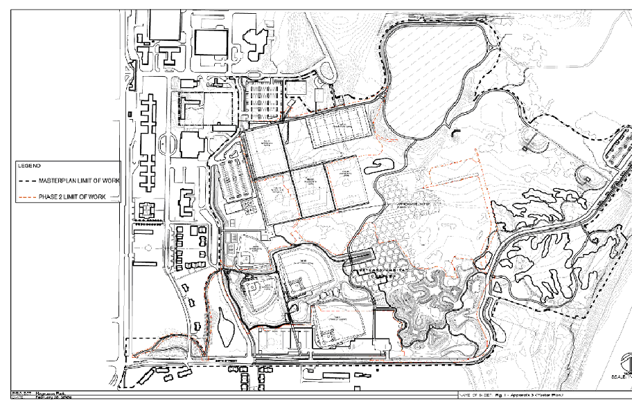
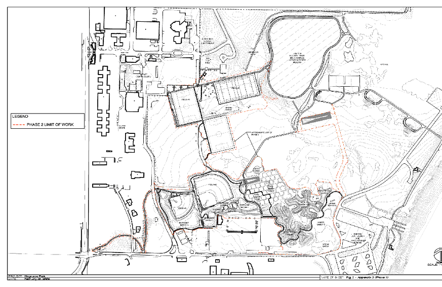