Form revised October 26, 2007
FISCAL NOTE FOR NON-CAPITAL PROJECTS
|
Department:
|
Contact Person/Phone:
|
DOF Analyst/Phone:
|
|
Department of Planning Development/Legislative
|
Susan McLain, DPD, 684-0432
Michael Jenkins, 615-1674
|
|
|
Legislation Title:
|
|
AN ORDINANCE relating to land use and zoning and the
Sand Point Overlay District; amending the
Official Land Use Map, Seattle Municipal Code (SMC) Chapter 23.32, to modify
and rename the subarea boundaries of the Sand Point Overlay District; and amending
Seattle Municipal Code Sections 23.72.004, 23.72.008, 23.72.010, and
23.84A.025.
|
·
Summary of the Legislation:
The Seattle Department of Parks and Recreation is proposing
to update use and development standards for the Sand Point Overlay District.
The proposed amendments would:
- allow additional land uses beyond those currently allowed;
- allow rooftop mechanical equipment to extend fifteen feet
above the height of existing buildings;
- allow the construction of a tennis center structure up to
45 feet tall;
- allow reconstruction of buildings on the footprint of
existing buildings; and
- expand the boundaries of the Overlay District to include
Building 27.
·
Background:
The amendments are intended to allow the continued reuse and
redevelopment of the former naval base at Warren G. Magnuson Park. The
original Overlay District was adopted by the City Council in 1997. Over time
it has become clear that some uses identified in the Sand Point Physical
Development Management Plan (1997) were not clearly identified as permitted
uses in the Land Use Code. Further, the Seattle Parks Department, manager of
the Park and the former naval base, has identified a need for more effective
signage and updated development standards. Finally, the transfer of Building
27 from the Federal government was completed in 2002, making it necessary to
formally include this former airplane hanger into the boundaries of the Sand
Point Overlay District.
The amendments will allow the former Sand Point naval station
to serve the recreation, education, arts, cultural, environmental and economic
development needs of the community. Thank you for your consideration of this
legislation.
·
Please check one of the following:
__X_ This
legislation does not have any financial implications. (Stop here and
delete the remainder of this document prior to saving and printing.)
Attachment A: Director’s Report
Background
The Seattle Department of Parks and Recreation (Parks) is
proposing amendments to the Land Use Code to assist the continued redevelopment
of the former naval base at Sand Point, now called Warren G. Magnuson Park. The
City owns, and Parks manages, Warren G. Magnuson Park, which is the site of a
former naval station. Development within the western portion of the former
naval station is regulated by the provisions of the Sand Point Overlay
District, adopted in 1997, as well as the underlying Single Family and Lowrise
zoning. The remainder of the site is regulated by the underlying Single Family
zoning and the Shoreline Master Program.
From 1925 to the early 1970s, the entire peninsula belonged
to the U.S. Navy as part of Naval Air Station-Seattle, known later as Naval
Station Puget Sound. The eastern portion of the peninsula was transferred to
the City in the mid-1970s for Magnuson Park. Beginning in 1991, when the
remainder of the base was identified for closure, the City took the lead in
developing a plan for reuse of the property. This effort culminated in
transfer of naval station property to the City of Seattle and to the University
of Washington.
In 1997 the City Council adopted the Sand Point Physical
Development Management Plan (Resolution 29429 and in 1999, Resolution 30063),
Sand Point Amendments to the Comprehensive Plan (Ordinance 118622), and the
Sand Point Overlay District (Ordinance 118624), which applies special use and
development standards to the area. The Sand Point Overlay District is the
subject of this report and will be discussed further on the following pages.
On November 1, 1999, the Seattle City Council
adopted a conceptual plan map (Resolution 30063) to provide guidance for future
design of the entire park/overlay district area. A vision statement was
crafted by the Sand Point Blue Ribbon
Committee for the Sand Point Magnuson Park to “…integrate multiple uses—park and recreation, the
arts, environmental protection and restoration, education and residential—which
will work together to create a unique park in our region...."
Ordinance
119299 authorized the Superintendent of Parks and Recreation to administer the
Sand Point Physical Development Plan, Construction Management Plan,
Transportation Plan, Parking Plan, Site Design Guidelines, Historic Properties
Reuse and Protection Plan, and any amendments to any of these or other plans
pertaining to the City's Sand Point properties that may be approved by the
City. The City owns the majority of the property, which Parks manages. The
organization Solid Ground has a 51-year lease for properties in the southwest
corner of the park, providing transitional housing and services. The University of Washington owns five buildings,
located primarily along the western boundary of the park.
The Sand Point Overlay District
In 1997 the City Council adopted the Sand Point Overlay District, Seattle
Municipal Code (SMC) chapter 23.72. In general, the overlay expands permitted
uses in the underlying single family and Lowrise zones “to integrate the
property into the city of Seattle as a multi-purpose regional center” to
provide recreation, education, arts, cultural and community activities; to
provide increased shoreline public access and enhanced open space and natural
areas; to provide affordable housing and social services for homeless families;
and to provide low-impact economic development to provide employment and
services for residents of the property and the broader community.
Overlay district development standards are also meant to address the unique
structures and other features at the former naval base that were not contemplated
by the underlying single family and multifamily zones. These features include former
airplane hangars and barracks and former airplane runways that serve as roads.
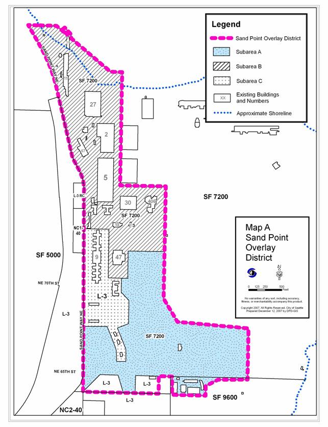
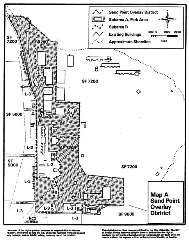
The overlay district (as proposed to be amended) is depicted on the following
map.
Sand Point Overlay
District Proposed Map
Proposed Land Use Code Changes
Land Use Code amendments to the overlay district will
allow the rehabilitation of several World War-era structures to be available
for active use by Seattle Parks and Recreation and the University of Washington.
Since transfer of the property from the federal government in 1995, both the
City and the University of Washington have made numerous unsuccessful attempts
to rehabilitate existing buildings for uses permitted under the existing Code.
Both entities have contemplated demolition of some of the buildings unless they
are able to modify them for productive use.
During 2005 Parks issued three requests for proposals to
develop programs for Magnuson Park. The proposed Land Use Code amendments will
allow Parks and its concessionaires and lessees to make improvements, occupy
the buildings and provide services at the park as contemplated by the planning
documents previously adopted by Council. City Council approval for concession
agreements and leases will be proposed under a separate action.
Land Use Code revisions will accommodate a multitude of
conditions that have changed since the inception of the overlay district. For
example, daily use of Warren G. Magnuson Park has increased and activity
patterns have changed since the establishment of the overlay district. The
City and the community have had time to refine plans for Magnuson Park, to
understand the needs and impacts of various uses, to understand the limitations
of remodeling World War-era buildings, and to manage use of the land on the
Sand Point peninsula.
Several uses and development standards were recommended by
the Sand Point Physical Development Management Plan but were not included in
the Sand Point Overlay District regulations. These uses and updated development
standards are proposed at this time.
The proposed amendments include changes to the Sand Point
Overlay District subarea boundaries, permitted uses, development standards, and
provisions for signage as follows:
1) Map
amendments. Amend the Sand Point Overlay Map and the Seattle Official Land Use
Map to modify the boundaries of the subareas of the overlay district, to add an
additional sub-area and rename the existing subareas, and to create a more readable
map. Existing and proposed maps are depicted in the appendices to this
report.
2) Amendments Relating to Permitted Uses within new
Sub-area B.
a) Remove “police training
facility” as a permitted use as this use is no longer anticipated.
b) Remove “motion picture
studios” as this is included in the definition of “custom and craft work,”
which is a current allowed use.
c) Allow retail sales accessory
to principal uses. Seattle Parks and Recreation envisions retail activities
such as kayak rental, gift shops or craft shops associated with arts uses.
Retail uses would only be allowed accessory to other permitted principal uses
in the overlay district, and would be limited to 6,000 square feet per
establishment.
d) Add new principal permitted
uses within sub-area B of the Sand Point Overlay District:
·
Dry boat storage, limited to storage of non-motorized,
hand-launchable boats such as kayaks, canoes and sail boats;
·
Motion picture theater not to exceed 500 seats within building
47;
·
Offices, limited to a total of 144,000 total square feet in the
entire sub-area;
·
Performing arts theater; and
·
Restaurants without drive-in lanes, limited to no more than 2,000
square feet per establishment.
3) Rooftop features on existing nonresidential buildings.
Allow rooftop structures for mechanical equipment and stair and elevator
penthouses on existing non-residential buildings to extend up to 15 feet above
the existing roof elevation.
4) Replacement of historic structures with new
structures. Allow historic structures to be replaced with new structures if
they are built on and limited to the footprint of the historic structures they
replace and if the demolition and replacement are consistent with the Sand
Point Historic Properties Reuse and Protection Plan. Spaces between structures
would continue to be maintained in open space use.
5) New tennis court structure. Allow one new indoor and
outdoor tennis structure up to 45’ in height, outside the footprint of an
historic structure.
Consistency with Applicable Plans and Policies
Several planning documents and legal agreements provide the
vision for the properties comprising Warren G. Magnuson Park. These are:
·
The Sand Point Amendments to the Comprehensive Plan (Ordinance
118622, 1997)
·
The Sand Point Physical Development Management Plan (Resolution
29429, 1997 and 30063, 1999)
·
The Sand Point Historic Properties Reuse and Protection Plan
(Resolution 29725, 1998)
·
Sand Point/ Magnuson Park Final Design Guidelines (Resolution
29624, 1997)
·
Recreation Use Covenant, Education Use Covenant and Historic
Preservation Covenant between the City of Seattle, the University of
Washington, the U.S. Secretary of the Interior and the U.S. Secretary of
Education.
1. The Sand Point Amendments to the Comprehensive Plan
provide land use, transportation, housing, capital facilities, utilities, and
economic development policies.
Land use policies in the Sand Point Amendments to the
Seattle Comprehensive Plan support the following uses within the overlay
district:
Policy LU2: Develop and
promote the northern part of the property (Activity Area 1) as the North
Shore Recreation Area with public park area, public access to Lake Washington,
recreational, arts and cultural opportunities, and a recreational small boat
activity center.
Policy LU3: Develop and promote
Activity Area 2 as an Education and Community Activities Area with open
public areas, opportunities for education and educational support activities,
selective economic development activities, and recreational, arts, and cultural
activities.
Policy LU4: Develop and promote
Activity Area 3 as an Arts, Culture and Community Center for the
development of arts, culture, community activities and open public areas in
existing buildings and adjacent outdoor spaces.
Policy LU5: Develop and promote
Activity Area 4 as a Park Open Space/Recreation Expansion of Magnuson Park.
Allow for an improved park entrance at the intersection of NE 65th
and Sand Point Way NE, additional sports fields, unstructured open space, and a
recreation center with gymnasium, theater, indoor swimming pool, and meeting
spaces in an existing building.
In addition, a general policy in the City’s Comprehensive
Plan identifies the overall role of former naval air station:
Policy CR 22: Develop portions of
the surplused Naval Station Puget Sound at Sand Point into a multi-purpose
regional facility to support the arts and cultural activity.
2. The Sand Point Physical Development Management Plan.
The Plan defines six activity areas, and provides guidance for infrastructure
development and site management of sport fields, an off-leash dog area, and
other recreational facilities.
The six activity areas in the Sand Point Physical
Development Management Plan are:
- North Shore Recreation Area (Buildings 11N, 11S, 31),
- Education and Community Activity Area (Buildings, 2, 5A,
5B, 5C, 5D, 9, 12, 25, 27, 29, 67, 192/141),
- Arts & Cultural Center (Buildings 18, 30, 41, 138, 406,
222, 223),
- Residential Areas (Buildings 6, 26N, 26S, 224, 310, 330,
331, 332, 333, 334),
- Magnuson Park Open Space & Recreation Expansion Area
(Buildings 15, 47, 345, 193, 228, 244, 301, 308, 340, 341, 344), and
- Federal Agency Acquisitions (Building 27).
The Sand Point Physical Development Management Plan
designated the North Shore Recreation Area for a small craft center and
waterfront park, including on-shore dry boat storage. The proposed amendments
would include Building 27 in overlay district subarea B. After the National
Oceanic and Atmospheric Administration declined to purchase the building and
surrounding lands, the City authorized acquisition of Building 27 from the
federal government. Ordinance 121015 authorizing final transfer of the property
was passed in 2002.
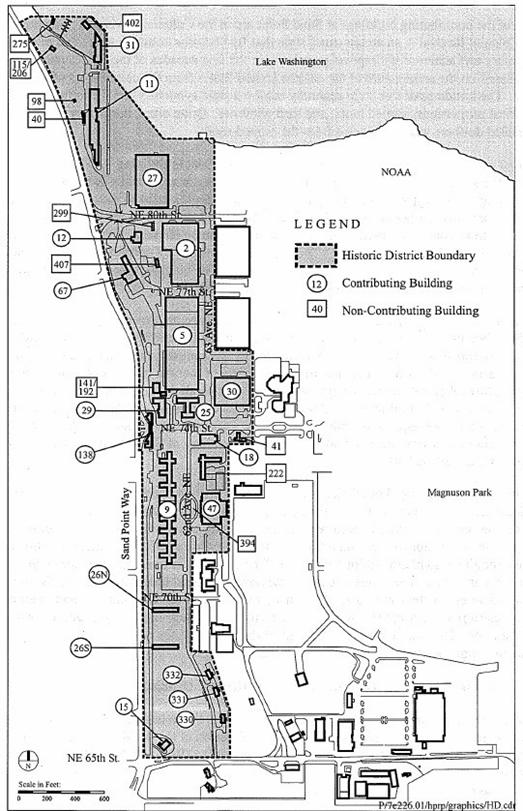
3. The Sand Point Historic Properties Reuse and
Protection Plan. The Sand Point Overlay District contains several older
buildings that comprise an historic district that is eligible for listing in
the National Register of Historic Places. Historic preservation covenants in
property transfer documents require that the City of Seattle and the University
of Washington review plans with and obtain approval of the Washington State
Historic Preservation Officer prior to initiation of certain construction, alteration,
remodeling, demolition or other action that would materially affect the
integrity or appearance of historic resources at Sand Point. A map of the Sand
Point Historic District can be found as Attachment C at the end of this
report.
4. The Sand Point/ Magnuson Park Final Design Guidelines
provide design guidance to physical development of the former Naval Air
Station-Seattle, including construction related to buildings, utilities,
recreational facilities, circulation systems, landscape and open space
treatment, demolition, public art and other development. The guidelines
provide detailed guidance on signs within the district.
5. Recreation Use Covenant, Historic
Preservation Covenant, and Education Use Covenant were included as part of
the Secretary of Interior’s transfer of the Sand Point Naval Station to the
City of Seattle. The Recreation Use Covenants require that the “property shall
be used and maintained for public park and recreation purposes in perpetuity”.
The Historic Preservation Covenant requires approval of the National Park
Service or its designee, the Washington State Historic Preservation Officer
(SHPO), for “any construction, alteration, remodeling, demolition, disturbance
of the ground surface, irrevocable disturbance of landscape settings, or other
action that would materially affect the integrity, appearance, or historic
value of structures or settings…” within the Sand Point Historic District.
The Education Use Covenant requires that University-owned property be used for educational
purposes for 30 years, and that the property not be used for any purposes
other than those approved in advance by the U.S. Department of Education.
Summary of Recent Public Outreach Efforts
Parks engaged in a
public outreach process in late 2006 to gather input on the proposals for the Magnuson Park campus development, including Land Use
Code amendments. In September 2006, information fliers were mailed to more
than 2,900 area residences informing them of upcoming meetings and the
opportunity for public comment at meetings and in writing. A new web page, “Sand
Point Historic District – Realizing the Vision” featured electronic copies of the
proposed Land Use Code amendments and the development proposal. The web page
and project contact information has remained online since 2006.
An open house was
held on Oct. 10, 2006 when citizens met development partners,
reviewed details of each proposal, asked questions, and took home informational
fliers. More than forty people attended. Parks staff also presented
information to the following community organizations: Magnuson Park Community
Communications Committee (Sept. 26); Northeast District Council (Oct. 5); View
Ridge Community Council (Oct. 17); and Magnuson Park Community Center Advisory
Council (Oct. 19).
In late October
2006, Parks mailed a flier to 5,600 residents summarizing what was heard at the
open house and at the various community meetings and announcing a public
hearing held by the Board of Park Commissioners on Nov. 9. Staff briefed the
Board of Park Commissioners on September 14 and November 9, 2006.
At that briefing, the six proposals submitted for the development of facilities
and programs in the buildings at Magnuson Park were described. The Board accepted
written public comments on the proposals from late September through December
13th. After extensive discussion at their meeting on December 14th,
the Board endorsed each of the proposals. The minutes and a video recording of
that meeting are available on the Seattle Parks Department web site.
Three
additional open house events were held in late November 2007 to provide
information about proposed concession agreements and Land Use Code amendments
and to receive public comments. Almost 300 members of the public attended.
Public
comment at the open house and at presentations to community groups and
testimony at the Board of Park Commissioners public hearing resulted in several
hundred comments on the following topics:
·
Use of Hangar 27 as a
single-use venue (indoor sports complex) vs. retaining it for community space
(roller skating, rummage/garage sales, etc.)
·
Improvements to indoor
sports facilities
·
Tennis center layout
with six indoor courts and three outdoor courts
·
Conversion of
racquetball courts to theater dressing rooms in Magnuson
Community Recreation Center gym
·
Inclusion of
commercial concessionaires (restaurants, recreation program management, etc.)
in a public park
·
Topics relating to
the proposed Land Use Code amendments: permitting electronic reader board signs
along Sand Point Way or NE
65th St.;
permitting larger signs on buildings
·
Impacts of traffic
and parking coupled with sports field development.
Discussion of the Proposed Amendments
1) Map and Boundary Amendment: Amend the Sand
Point Overlay Map to modify boundaries of the subareas of the overlay district,
to add an additional sub-area and rename others in order to create a more
readable map. A copy of the existing and proposed “Sand Point Overlay
District” is depicted on the final pages of this report. The existing map
found in Section 23.72.004 of the Land Use Code was last amended in 1997.
Building 27 was still under Federal ownership at the
inception of the Sand Point Overlay District. At that time, the building was
intended to be part of the National Oceanic and Atmospheric Administration
(NOAA) campus. That building is no longer needed by NOAA, and final transfer
of the building to the City was authorized in 2002 by Ordinance 121015. It is
serving recreation uses.
Parks is proposing that Map A of the Sand Point Overlay
District be amended to include three sub-areas as follows.
- Sub-area A includes areas with
SF 7200 underlying zoning.
- Sub-area B includes areas with
SF 7200 underlying zoning. It is proposed that Sub-area B include Building
27.
- Sub-area C includes areas with
L3 zoning, except for the 2 areas of L-3 zoning at the far southern end of
the Overlay District, which will remain in the District but outside of any
subarea.
2) New Permitted Principal Uses.
·
Dry boat storage, limited to non-motorized, hand-launchable boats
such as kayaks, canoes and sailboats
The Sand Point Physical Development Management Plan called
for the creation of a “small craft center” in the North Shore Recreation Area.
Phase one renovation of the North Shore Recreation Area was completed in
mid-2006. This project created a new fish-friendly beach, new docks, and
upland areas to support non-motorized boating activities such as dry boat
storage.
Parks requests that “dry boat storage, limited to
non-motorized, hand-launchable boats such as kayaks, canoes and sailboats” be
permitted as a principal use within new sub-area B in the overlay district. A
small boat house currently exists in the North Shore Recreation Area—the only
shoreline area within the Overlay District. Expanded dry storage of boats will
complement the small craft center in building 11 and the existing boat house.
·
Motion picture theater not to exceed 500 seats in building 47
·
Performing arts theater
Partial renovation of Building 47, originally a Navy
recreation center, was completed in 2003. The building is currently used as
the Magnuson Community Center. An existing 500-seat theater from the naval era
is located in one wing of the building. Various buildings have housed
temporary performing arts theater events through temporary use permits over the
past four years. Seattle Parks and Recreation requests that a “motion picture
theater not to exceed 500 seats in building 47” and “performing arts theaters”
be permitted uses in new sub-area B of the overlay district. This provision
would allow other structures to be used as performing arts theaters elsewhere
in new sub-area B.
The proposed community recreation activities are consistent
with both the Sand Point Amendments to the Comprehensive Plan and the 1997 Sand
Point Physical Development Management Plan. The motion picture theater is
expected to provide a possible location for film series and film festivals
consistent with its current use. The motion picture theater could not exceed
the 500 seat capacity of the existing facility, thereby limiting potential
impacts to those currently present.
·
Offices, limited to 144,000 total square feet in the entire sub-area
Principal office uses would be limited to a total of 144,000
square feet in the entire new sub-area
B. Principal office uses are currently permitted without
limit within L3 zoned areas of the overlay district, the area that will become
sub-area C on the new map. The square foot limitation in subarea B would reduce
the possibility of a proliferation of administrative office uses that could
detract from the public amenities focus of Sand Point. This proposed
limitation is consistent with existing principal office spaces within new
sub-area B as identified in Attachment D of this report.
The Recreation Use Covenant and the Education Use Covenant
associated with the property transfer restrict uses to those that are
consistent with the recreation- and education-related functions of the
district. Several existing non-profit tenants, such as Plant Amnesty and
EarthCorps, have principal use offices within the Overlay District.
·
Restaurants without drive-in lanes, limited to no more than 2,000
square feet per establishment
The proposed amendment would permit restaurant uses within
proposed sub-area B of the Overlay District. Restaurant uses of unlimited size
are already allowed outright in the Lowrise-zoned proposed sub-area C. Building
11 has been identified as a potential location for a restaurant. Parks staff has not identified any other
locations at this time.
Seattle Parks Department staff notes that restaurant uses in
parks are not a new concept. While never formally acknowledged by City
Council, the original Sand Point Park Master Plan (1975) identified a
restaurant in the eastern portion of the park near the current motorized boat
launch. Two other local park systems offer examples of commercial food
concessions in parks today. The City of Renton has operated an Ivar’s and Kidd
Valley food concession at Gene Coulon Memorial Beach Park for 18 years. King County has operated a Subway and a Blazin’ Bagels restaurant at Marymoor
Park since 2005.
3) Rooftop Structures.
Allow limited rooftop structures for stair and elevator
penthouses and mechanical equipment on existing nonresidential buildings to
exceed height limits.
Most of the nonresidential buildings in the Sand Point
Overlay District were constructed in a twenty year period prior to the Second
World War. They generally consist of an initial core structure and multiple additions
that expanded the footprint or height. Due to the age and condition of the
buildings, they all require significant renovation to meet current building and
energy code requirements. A majority of the buildings feature finished roof elevations
greater than the residential height limit of thirty feet that applies throughout
the overlay district. Roof heights on several existing buildings range up to fifty
or sixty feet.
Construction of elevators and modern mechanical equipment in
these buildings will require rooftop structures taller than currently
permitted. Parks is requesting that certain rooftop structures on existing
nonresidential buildings be permitted to extend up to fifteen feet above the
existing roof elevation or fifteen feet above the maximum height limit,
whichever is higher. The combined total coverage of all rooftop features permitted
to extend above the height limit and above the existing roof elevation would
not be allowed to exceed twenty five percent of the roof area or thirty percent
of the roof area if the combined features include screened mechanical
equipment. According to the proposed legislation, “The addition of rooftop
features shall be consistent with the Sandpoint Historic Properties Reuse and
Protection Plan dated April 1998, as evidenced by a letter of approval from the
Sand Point Historic Preservation Coordinator.”
4) New Structures
Proposed amendments would:
- Eliminate the requirement that the additional permitted
uses only be allowed in structures existing as of 1997, the effective date
of Chapter 23.72 of the Land Use Code.
- Allow new structures if “limited to the footprint of a
structure that existed on the site” as of 1997, and if consistent with the
Sand Point Historic Properties Reuse and Protection Plan, dated April 1998,
as documented by the review and approval of the State Historic
Preservation Officer. Allow new structures to be built to the height of
the existing height limit or the height of any structure they replace,
whichever is higher.
- The footprint restriction and maximum height limitations
above would not apply to any proposed new indoor/outdoor tennis facility,
whose height would be restricted to 45 feet. The footprint restriction
also would not apply to affordable housing units built in the L-3 zones.
Since the Sand Point Overlay District was transferred from
the Federal government to the City of Seattle, dilapidated conditions,
escalating construction costs, the presence of hazardous materials, and
unsuitable building layout have made reuse of some buildings infeasible under
the existing Overlay District Code. In some cases, both the City and the University
of Washington want to either construct new buildings or creatively adapt
existing buildings to accommodate viable uses within the overlay district. In
other cases, both entities have considered mothballing existing buildings that
are not viable for renovation.
Current Land Use Code provisions for the Sand Point
Overlay District do not prohibit demolition of existing buildings, nor do they
prohibit construction of new buildings. Overlay provisions do, however,
require that the “additional uses” permitted only by the overlay zone be
located only in buildings that existed prior to July 18, 1997; they cannot be located in new buildings. This effectively limits the uses allowed in new
buildings to the uses permitted by the underlying Single Family zoning, which
is not economically attractive, and which effectively discourages construction
of new buildings.
The proposed Code amendments would allow the “additional
principal uses permitted within the overlay district” to be located in either
new or existing buildings—they would no longer limit those uses to the
buildings existing prior to July 18, 1997. Except for a tennis center and affordable
housing in Lowrise 3 portions of the District, the proposed amendments require
that any new construction be limited to the footprint of a former building and
the higher of the maximum height limit or the height of a former building. In
addition, any areas between structures, paved parking areas and rights of way
are limited to open space uses. In this way, the amendments explicitly require
the retention of open space between buildings and paved areas consistent with
the intent of current Code provisions.”
The retention of historic character is an important value
for the Sand Point Overlay District. Through the transfer agreement with the
Federal government and the associated Historic Preservation Covenant, the City
of Seattle agreed to “make every effort to retain and reuse to the extent
practicable, the historic structures.”
The Historic Preservation Covenant allows construction, alteration, remodeling,
demolition of structures within the historic district, but only with the
approval of the National Park Service or Washington Historic Preservation
Officer, pursuant to a detailed process identified in the Sand Point Historic
Properties Reuse and Protection Plan (HPRP) of 1998. The proposed amendments
require compliance and consistency with the HPRP to be documented by the State
Historic Preservation Officer or the Sand Point Historic Preservation
Coordinator.
5) Tennis Center:
Allow a new structure for an indoor and outdoor tennis center only in
sub-area B.
The proposed amendment would permit a new structure for an
indoor and outdoor tennis center within new sub-area B without it being located
on the footprint of a prior building. In 2002 Seattle Parks worked with a
citizen’s group to develop a conceptual design for an indoor and outdoor tennis
center to be located between Buildings 18 and 47. The center was to include
six indoor courts and eight outdoor courts. In 2006 the concept was
re-initiated on a smaller scale, and six outdoor courts were proposed to be
constructed and enclosed with an air-supported structure. Public meetings at
the end of 2006 demonstrated strong community support for this concept. This
amendment is an exception to the proposed change in development standards that
will permit new structures in the Single Family zone to be constructed on the
footprint of existing structures and extend up to the height of the original
structure. The tennis structure would be allowed where no existing building
currently exists and it would be allowed to extend up to 45-feet above finished
grade.