Attachment 2
TRANSPORTATION ELEMENT
A. ENVIRONMENTAL STEWARDSHIP
Goals
TG1 Improve environmental quality.
TG2 Reduce and/or mitigate air, water, and noise pollution from motor vehicles.
TG3 Promote energy-efficient transportation.
Discussion: Increased trips by motor vehicles, increased travel time, congestion, and longer trips all contribute to deteriorating environmental quality. Policies in other parts of the plan and elsewhere in the transportation element that reduce car use, support transit, and encourage walking and bicycling are key to reducing transportation-related environmental impacts. In addition, the policies below address specific air, water, and noise environmental impacts.
POLICIES
T1 Identify, evaluate, and fully consider environmental impacts of transportation investments and operating decisions. Pursue transportation projects, programs, and investment strategies consistent with noise reduction, air quality, and water quality objectives.
T2 Seek, recognize, and reward use of alternative fuels, energy-efficient modes, and other environmentally-sound technologies. Coordinate with the private sector and other public agencies to promote the use of low- and zero-emission vehicles by large fleet operators, including public transportation providers. Encourage King County/Metro, Community Transit, Sound Transit, and Pierce Transit to purchase buses that do not use diesel fuel. Consider developing and support state and regional efforts to develop long-term goals for the use of zero-emission, alternative-fuel, and energy-efficient vehicles by the general public. (Amended 11/99)
T3 Coordinate with county, regional, state, and federal agencies with air quality responsibilities. Seek to ensure that the City's transportation projects and programs conform with state and federal law.
T4 Work with county, regional, and state agencies to improve the programs and management strategies of the City, county, regional and state agencies that are designed to prevent and reduce contamination of street runoff and stormwater.
T5 Work with the state Department of Transportation, public transportation providers, and the public to identify, design, and incorporate noise mitigation measures into existing and planned traffic and transit operations and capital improvements. Encourage air and rail transport operators to reduce and mitigate their noise impacts.
B. CHANGING AND MANAGING TRAVEL
Goals
TG4 Meet the current and future mobility needs of residents, businesses, and visitors with a balanced transportation system.
TG5 Provide a range of viable transportation alternatives, including transit, bicycling, and walking.
TG6 Reduce use of the car over time.
Discussion: To slow the trend of increasing car use, the City must provide alternatives and must change the way people think about and act upon travel choices. Transportation alternatives to the car need to respond to people's needs for mobility, privacy, comfort, safety, and convenience. The City recognizes that transportation needs and travel choices will change over time as alternatives to car travel become more viable.
POLICIES
T6 Educate the public, especially youth, about the individual and societal benefits of alternatives to cars. Encourage incentives and support efforts to induce future generations to become regular users of transit and non-motorized modes.
T7 Initiate and support public awareness campaigns that focus attention on the societal and environmental impacts and costs of travel choices, and that make people aware of the range of travel choices available. Inform those who now commute by single-occupant vehicle about the economic, societal, and environmental costs of their choices. Support federal, state, and other efforts that increase the single-occupant vehicle driver's share of the true cost of car use.
T8 Support and promote commute trip reduction (CTR) programs, telecommuting, electronic communications, variable work weeks, flextime, and a variety of travel demand management (TDM) strategies aimed at reducing the number and length of car trips and increasing the efficiency of the transportation system. Accomplish this by developing and implementing with a coordinated program of incentives, alternative travel options, land use measures, innovative design, regulations, services, and marketing strategies. Allow developers to choose among TDM strategies. Where appropriate, pursue TDM strategies at the regional level, and strengthen regional partnerships working on TDM measures. For all modes sSupport implementation of advanced transportation and communications technologies, such as intelligent vehicle, highway, arterial, and transit systems.
T9 Support the efforts of the state Department of Transportation to complete the freeway high-occupancy-vehicle (HOV) lane system throughout the central Puget Sound region.
T10 Evaluate, against the following mode choice goals, the success of the City's and the region's land use strategies, and transportation systems and programs, in reducing single-occupant vehicle use.
Travel modes for work trips by Seattle residents:
|
Year |
|
1990 |
2000 Goal |
2010 Goal |
|
|
Single-occupant car |
59% |
51% |
35% |
|
Non-single-occupant car: |
|||
|
Carpool |
12% |
12% |
13% |
|
Public transportation |
16% |
20% |
27% |
|
Bicycle and other |
3% |
5% |
9% |
|
Walk |
7% |
8% |
10% |
|
Work at home |
3% |
4% |
6% |
|
Total |
100 % |
100 % |
100 % |
For non-work trips by Seattle residents, the goals are to increase transit use from 7% in 1990 to 9% in 2000 and 14% in 2010.
These are planning goals only, and are not intended as concurrency standards.
C. LAND USE AND TRANSPORTATION
Goal
TG7 Ensure that land use and transportation decisions, strategies, and investments are coordinated, are complementary, and support the urban village strategy.
Discussion: Land use and transportation are fundamentally interrelated. The urban village strategy recognizes this relationship by focusing development in concentrated rather than linear patterns, directing transit investments to link these pedestrian-oriented activity centers, and providing more opportunities for walking and bicycling. However, the City recognizes that auto access to property will continue to be a key element in accommodating growth in centers and villages.
Policies
T11 Provide adequate transportation facilities and services to promote and accommodate growth and change in urban centers, urban villages, and manufacturing/industrial centers. Seek to provide transit, services and walking and bicycling opportunities services and improvements to enable urban centers and urban villages to reach growth targets or planning estimates in a way that minimizes single-occupant vehicle travel.
T12 Design and build transportation facilities to reflect the character of the surrounding neighborhood, reinforce the activities desired in the surrounding area, address community development goals, and be convenient, comfortable, and safe. Make the scale of transportation facilities consistent with surrounding land uses.
T13 Involve the public in identifying needs for, planning, and designing transportation facilities, programs, and services. Encourage and/or provide opportunities for extensive public involvement opportunities, both forin City decisions, and encouragefor those of other agencies to do the same. As part of this process, address the special needs of low-income people, children and youth, the elderly, people with disabilities, businesses, and residents.
T14 Encourage a mix of complementary neighborhood businesses and services in urban villages to encourage short trips easily made by walking or bicycling.
D. USE OF STREETS
Goals
TG8 Make the best use of the City's limited street capacity, identify key functions of streets, and seek to balance competing uses.
TG9 Ensure adequate capacity on the street system for transit and other important uses.
TG10 Support a shift towards transit, carpools and vanpools, bicycling, and walking.
TG11 Support efficient freight and goods movement.
G12 Differentiate among the various functions of City streets.
TG132 Protect neighborhood streets from through traffic.
Discussion: The City has a limited amount of street space, and is unlikely to expand this space significantly. Thus this space must be carefully allocated among competing uses to further the City's goals.
Policies
T15 Designate principal arterials, a transit priority network, and major truck streets as described in the policies in this and other sub-elements, to identify the key functions of these streets. Make operating, design, access, and/or service changes to enhance the key functions of these streets when congestion significantly hinders the key functions. Changes to these streets to enhance their key function(s) should maintain or enhance pedestrian facilities and operations, taking into consideration the expected type and volume of traffic, safety, accessibility, and aesthetics for pedestrians walking along and crossing a street. (Amended 11/95)
T16 Designate principal arterials as shown in Transportation Figure 1. Design, operate, and regulate access along principal arterials to accommodate and facilitate through traffic and connect with regional facilities. Direct through traffic onto principal arterials and away from local streets. Continue to designate other classes of arterials in the Seattle Comprehensive Transportation Program.
T17 Coordinate with the state Department of Transportation and adjacent jurisdictions to discourage diversion of traffic from regional roadways and principal arterials onto lesser arterials and local streets.
T18 Use neighborhood traffic control devices and strategies to protect local streets from through traffic, high volumes, high speeds, and pedestrian/vehicle conflicts. Use these devices and strategies on collector arterials where they are compatible with the basic function of collector arterials.
T19 Manage the street system safely and efficiently for all modes and users, and emphasize pedestrian safety. Accommodate emergency vehicles.
T20 Do not attempt to provide street space to meet latent demand for travel by car. Do not pursue freeway expansion for the sole purpose of increasing general traffic capacity. Increase capacity of principal arterials where and as appropriate, either by expansion or by operating changes. Increase capacity on streets other than principal arterials only if needed to improve safety; but allow increased capacity for isolated connections to regional roadways to maintain the integrity and continuity of the street system, or if needed to achieve level-of-service standards. Use transportation system management (TSM) techniques as appropriate to manage street space. Reallocate street space among various uses (e.g., general traffic, transit, trucks, carpools, bicycles, parking, pedestrians) as needed to enhance the key function(s) of a street.
T20.51 Seek to reduce damage to Seattle’s roads and bridges that is caused by heavy vehicles, including transit. Accordingly, encourage transit agencies to purchase buses that are as light as is practical. Pursue strategies to finance repair of road damage in a way that is equitable for Seattle’s taxpayers. (New policy added 11/99)
TRANSPORTATION FIGURE 1
Principal Arterials
Note: Figure 1, Principal Arterials, is omitted from this attachment because no amendments are proposed for Figure 1; it is retained without amendment.
E. LEVEL-OF-SERVICE
Goal
TG134 Use level-of-service standards, as required by the Growth Management Act, as a gauge to judge the performance of the arterial and transit system.
Discussion: The Growth Management Act requires that the Comprehensive Plan include arterial and transit level-of-service standards to be used as a gauge to judge the performance of the system. The standards identify minimally acceptable travel conditions on arterials and the transit network. They focus on characteristics of the transportation system over which the City has some influence and control. Given the standards established below, the City's facilities currently comply with these standards.
Policies
T212 Arterial Level-of-Service: Define arterial level-of-service (LOS) to be the volume-to-capacity ratio (v/c) at designated screenlines, each of which encompasses one or more arterials, as shown in Transportation Figure 2. Measure peak hour directional traffic volumes on the arterials crossing each screenline to calculate the screenline LOS. To judge the performance of the arterial system, compare the calculated LOS for each screenline with the LOS standard for that screenline shown in Transportation Figure 3. (Amended 11/99)
T223 Transit Level-of-Service: Define transit level-of-service (LOS) to be the volume-to-capacity ratio (v/c) at designated screenlines, each of which encompasses one or more arterials, on some of which transit operates, as shown in Transportation Figure 2. Measure peak hour directional traffic volumes on the arterials crossing each screenline to calculate the screenline LOS. To judge the performance of the transit system, compare the calculated LOS for each screenline with the LOS standard for that screenline shown in Transportation Figure 3. (Amended 11/99)
T234 Complying with Level-of-Service Standards: When the calculated LOS for a screenline approaches the LOS standard for that screenline, pursue strategies to reduce vehicular travel demand across the screenline and/or increase the operating capacity across the screenline.
TRANSPORTATION FIGURE 2
Level of Service
(LOS) Screenlines
Note: Figure 2, Level of Service (LOS) Screenlines, is omitted from this attachment because no amendments are proposed for Figure 2; it is retained without amendment.
Transportation Figure 3
LEVEL-OF-SERVICE (LOS) STANDARDS
|
Screenline Number |
Screenline Location |
Segment |
Direction |
199 AM PM |
LOS Standard |
|
|
1.11 |
North City Limit |
3rd Ave NW to Aurora Ave N |
NB SB |
0.34 |
0.82 |
1.20 |
|
0.63 |
0.50 |
|||||
|
1.12 |
North City Limit |
Meridian Ave N to 15th Ave NE |
NB SB |
0.32 |
0.68 |
1.20 |
|
0.71 |
0.38 |
|||||
|
1.13 |
North City Limit |
30th Ave NE to Lake City Way NE |
NB SB |
0.41 |
0.84 |
1.20 |
|
0.89 |
0.54 |
|||||
|
2 |
Magnolia |
EB WB |
0.56 |
0.48 |
1.00 |
|
|
0.33 |
0.60 |
|||||
|
3.11 |
Duwamish River |
West Seattle Fwy and Spokane Street |
EB WB |
0.72 |
0.41 |
1.20 |
|
0.29 |
0.76 |
|||||
|
3.12 |
Duwamish River (see Note 1) |
1st Ave S and 16th Ave S |
NB SB |
0.73 |
0.42 |
1.20 |
|
0.36 |
0.72 |
|||||
|
4.11 |
South City Limit |
ML King Jr Way to Rainier Ave S |
NB SB |
0.36 |
0.35 |
1.00 |
|
0.25 |
0.47 |
|||||
|
4.12 |
South City Limit |
Marine Dr SW to Meyers Way S |
NB SB |
0.29 |
0.31 |
1.00 |
|
0.20 |
0.39 |
|||||
|
4.13 |
South City Limit |
SR 99 to Airport Way S |
NB SB |
0.53 |
0.38 |
1.00 |
|
0.32 |
0.44 |
|||||
|
5.11 |
Ship Canal |
Ballard Bridge |
NB SB |
0.48 |
1.03 |
1.20 |
|
0.97 |
0.60 |
|||||
|
5.12 |
Ship Canal |
Fremont Bridge |
NB SB |
0.53 |
0.99 |
1.20 |
|
0.73 |
0.64 |
|||||
|
5.13 |
Ship Canal |
Aurora Ave N |
NB SB |
0.47 |
0.98 |
1.20 |
|
0.97 |
0.65 |
|||||
|
5.16 |
Ship Canal |
University and Montlake Bridges |
NB SB |
0.72 |
0.94 |
1.20 |
|
0.89 |
0.89 |
|||||
|
6.11 |
South of NW 80th St |
Seaview Ave NW to 15th Ave NW |
NB SB |
0.19 |
0.43 |
1.00 |
|
0.40 |
0.28 |
|||||
|
6.12 |
South of NW 80th St |
8th Ave NW to Greenwood Ave N |
NB SB |
0.22 |
0.48 |
1.00 |
|
0.39 |
0.31 |
|||||
|
6.13 |
South of N(E) 80th St |
Linden Ave N to 1st Ave NE |
NB SB |
0.20 |
0.43 |
1.00 |
|
0.39 |
0.30 |
|||||
|
6.14 |
South of NE 80th St |
5th Ave NE to 15th Ave NE |
NB SB |
0.25 |
0.65 |
1.00 |
|
0.62 |
0.36 |
|||||
|
6.15 |
South of NW 80th St |
20th Ave NE to Sand Point Way NE |
NB SB |
0.22 |
0.47 |
1.00 |
|
0.50 |
0.33 |
|||||
|
7.11 |
West of Aurora Ave |
Fremont Pl N to N 65th St |
EB WB |
0.57 |
0.46 |
1.00 |
|
0.32 |
0.60 |
|||||
|
7.12 |
West of Aurora Ave |
N 80th St to N 145th St |
EB WB |
0.40 |
0.42 |
1.00 |
|
0.29 |
0.50 |
|||||
|
8 |
South of Lake Union |
EB WB |
0.53 |
0.81 |
1.20 |
|
|
0.92 |
0.92 |
|||||
|
9.11 |
South of Spokane St |
Beach Dr SW to W Marginal Way SW |
NB SB |
0.41 |
0.33 |
1.00 |
|
0.27 |
0.50 |
|||||
|
9.12 |
South of Spokane St |
E Mrginal Way S to Airport Way S |
NB SB |
0.64 |
0.51 |
1.00 |
|
0.38 |
0.62 |
|||||
|
9.13 |
South of Spokane St |
15th Ave S to Rainier Ave S |
NB SB |
0.61 |
0.54 |
1.00 |
|
0.33 |
0.63 |
|||||
|
10.11 |
South of Jackson St |
E Marginal Way S to Airport Way S |
NB SB |
0.64 |
0.61 |
1.00 |
|
0.50 |
0.66 |
|||||
|
10.12 |
South of Spokane St |
Alaskan Way S to 4th Ave S |
NB SB |
0.59 |
0.46 |
1.00 |
|
0.28 |
0.62 |
|||||
|
12.12 |
East of CBD |
EB WB |
0.37 |
0.55 |
1.20 |
|
|
0.85 |
0.64 |
|||||
|
13.11 |
East of I-5 |
NE Northgate Way to NE 145th St |
EB WB |
0.38 |
0.66 |
1.00 |
|
0.48 |
0.52 |
|||||
|
13.12 |
East of I-5 |
NE 65th St to NE 80th St |
EB WB |
0.27 |
0.42 |
1.00 |
|
0.38 |
0.39 |
|||||
|
13.13 |
East of I-5 |
NE Pacific St to NE Ravenna lvd |
EB WB |
0.61 |
0.58 |
1.00 |
|
0.39 |
0.70 |
|||||
NOTES:
1 - Capacity increase for screenline 3.12 to 7800 NB & SB in 1999 (1st Ave S. Bridge).
F. PARKING
Goals
TG154 Provide enough parking to sustain the economic viability and vitality of commercial areas while discouraging commuting by single-occupant vehicle.
TG165 Reduce use of cars over time, particularly for commute trips.
TG176 Make the best use of the City's limited street space, seek balance among competing uses, and protect neighborhoods from overflow parking.
Discussion: Long- or short-term parking is part of every car trip, and is a key factor in the choice of mode for a trip. The availability and price of parking influences people's choices about where to live, work, shop, and conduct personal business. Parking policies can influence car use. ; tThe challenge is to provide enough parking to meet mobility and economic needs, while limiting supply to encourage people to use non-auto modes. In addition to these policies, policy H5 in the housing element of this Plan provides guidance regarding parking.
Policies
T245 Coordinate Seattle's parking policies with regional parking policies, and with those of adjacent jurisdictions, in part to preserve Seattle's competitive position in the region.
T256 Consider imposing a commercial parking tax, but only if it is imposed regionally. Use commercial parking tax revenues, at least in part, to enhance non-auto modes.
T267 Consider establishing maximum parking limits for long- and short-term off-street parking to be provided by new non-residential development, tied to the changing availability of non-auto modes in a particular area. Review minimum parking requirements and maximum limits periodically as conditions change, such as land use mix, land use density, and the availability of transit and other non-auto modes.
T278 Balance the removal of long- and short-term on-street parking over time with the availability of non-auto modes and with the availability of off-street parking, in part to preserve the vitality of commercial areas. The decision to remove on-street parking may require balancing a number of policy objectives. For arterials, policy objectives include safety, sufficient on-street parking to support business districts and prevent spillover parking in residential areas, a pleasant pedestrian environment, truck access and loading and effective operation of the street for high occupancy vehicles, including transit, and bicycles. For urban centers and urban villages the pedestrian environment and transit operations are particularly important considerations.
T289 Allow long-term parking on most collector arterials and local streets, limited only by safety, street design, and property access needs. Use strategies such as parking duration limits,and/or time-of-day limits, or restricted parking zones (RPZs), where appropriate, to discourage commuter parking and to discourage parking from commercial areas or other activity centers from spilling over onto residential streets.
T2930 Allow flexibility and strive toward efficiency in meeting the long-term parking needs of new development in commercial areas, urban centers, and urban villages, by using strategies such as discouraging long-term accessory parking for single-occupant vehicles, while allowing principal use parking.
T301 Emphasize short-term parking over long-term parking in commercial areas, both on-street and off-street.
T312 Establish or maintain minimum long-term and/or short-term off-street parking requirements for new development for special vehicles and purposes, where appropriate, such as carpools, vanpools, bicycles, zero-emission vehicles, and vehicles for persons with disabilities.
T33 Discourage the development of major, stand-alone park-and-ride facilities within Seattle. Situations where additions to park-and-ride capacity could be considered include:
G. TRANSIT AND PUBLIC TRANSPORTATION
Goals
TG187Provide mobility and access by public transportation for the greatest number of people to the greatest number of services, jobs, educational opportunities, and other destinations.
TG198 Increase transit ridership, and thereby reduce use of single-occupant vehicles to reduce environmental degradation and the societal costs associated with their use.
Discussion: Providing convenient and accessible transit service can help to slow the increase in the use of single-occupant automobiles, slow the increase in environmental degradation associated with their use, and increase mobility without building new streets and highways. Street rights-of-way are limited; and Aas streets get more congested, transit in its own lanes or with other priority treatment can help people move around the city and the region. The transit system will need to change to respond to people's behavior and travel needs. A mMajor investment willmay be needed to provide more innovative transit service, while some actions can be taken which are low cost. along with related lLand use changes and capital facilities can strengthen the transit system, increase ridership, and provide greater mobility choices for Seattle citizens, employees and visitors. These policies will guide City decisions to enhance transit, and are also intended to guide decisions of other agencies that operate transit or ferries to, from, or within Seattle.
Policies
T324 Designate the transit priority network as shown in Transportation Figure 4. Monitor bustransit speeds and operations along the transit priority network and, where needed, pursue measures to increase bus transit speeds and reliability, reduce delay, and support demand. Continue to designate other transit classifications through the Seattle Comprehensive Transportation Program.
T335 Strive to maintain at least the minimum goals for bus speeds listed below, and higher speeds where possible, wWorking with King County Metro and making changes as warranted to City street design and/or operations. Focus on designated segments of the transit priority network, monitoring average p.m. peak period directional bus speed, excluding dwell time (time stopped for loading/unloading passengers).
--Outside urban centers: 40 percent of posted speed limit;
--Inside urban centers: 6 mph.
These are planning goals only, and are not level-of-service standards.
to develop a program for improving transit speed and reliability. Identify segments of the transit network for improvement using performance measure which may include:T346 Support development of an integrated, multi-modal, regional transportation system that links urban centers within the city and the region, and includes commuter rail, new rapid rail and/or light rail, interstate passenger rail, ferries, regional and local-service buses, community feeder/circulator services, taxis, carpools, vanpools, bicycles, pedestrians, and support facilities. Design and operate the facilities and services to make inter-modal transfers easy and convenient.
T35 Pursue high-capacity transit service (rail and/or bus) linking urban centers with appropriate densities within the city and the region.
T36 Encourage and support transit services that address the needs of persons with disabilities, the elderly, other people with special needs, and people who depend on public transit for their mobility.
T37 Work actively toward a citywide transit system -- the Local Initiative for Neighborhood Circulation (LINC) -- that includes both limited-stop, frequent intermediate capacity transit service connecting urban centers, urban villages, and manufacturing/industrial centers; and intra-community feeder service connecting homes and businesses with neighborhood transit facilities. Intermediate capacity service may include limited-stop express bus service, and shared or exclusive right-of-way, guideway, or grade-separated facilities for rail or rubber-tired transit. The intra-community service may include small vehicles, flexible routes, demand-responsive or dial-a-ride service, subsidized taxis, night shuttles, or other types of service.local fixed-route bus service and shuttles, and other types of transit services and technologies appropriate to the local transit market and environment.
TRANSPORTATION FIGURE 4
Transit Priority Network
Note: Figure 4, Transit Priority Network, is omitted from this attachment because no amendments are proposed for Figure 4; it is retained without amendment.
T38 Work with the transit provider(s) to provide transit service that:
T38.59 Work with the Regional Transit AuthoritySound Transit to ensure that the design of stations and alignments of the newLink light rail system and Sounder commuter rail system which will dramatically change how people move through and perceive the city, contributes positively to Seattle’s civic identity and reflects the cultural identity of the communities in which they are located.
T3940 Integrate transit stops, stations, and hubs into existing communities and business districts to make it easy for people to ride transit and to reach local businesses. Provide adequate lighting, security, pedestrian amenities, bike parking and weather protection. Minimize the negative impacts of transit service and facilities on surrounding areas.
T41 Encourage and support transit services that address the needs of persons with disabilities, the elderly, other people with special needs, and people who depend on public transit for their mobility.
T420 Support efficient use of ferries to move passengers and goods to and from Seattle. Encourage the Washington State Ferry System to expand its practice of giving loading and/or fare priority to certain vehicles, such as transit, carpools, vanpools, bicycles, and/or commercial vehicles, on particular routes, on certain days of the week, and/or at certain times of day. Encourage the Ferry System to integrate transit loading and unloading areas into ferry terminals, and to provide adequate bicycle capacity on ferries and adequate and secure bicycle parking at terminals.
T431 Encourage the Washington State Ferry System and others to expand the use of passenger-only ferries on appropriate routes.
H. PEDESTRIANS AND BICYCLES
Goals
TG2019 Increase walking and bicycling.
TG210 Create desirable, safe, convenient environments that are conducive to walking and bicycling.
Discussion: With supportive land use and transportation policies, walking and bicycling can be practical alternatives to driving (especially for short trips), contribute greatly to the quality and vitality of the street scene, and help achieve environmental goals. Pedestrian and bike improvements to intersections, sidewalks, and other facilities can improve access and safety, and are particularly important for children, senior citizens, and people with disabilities.
Policies
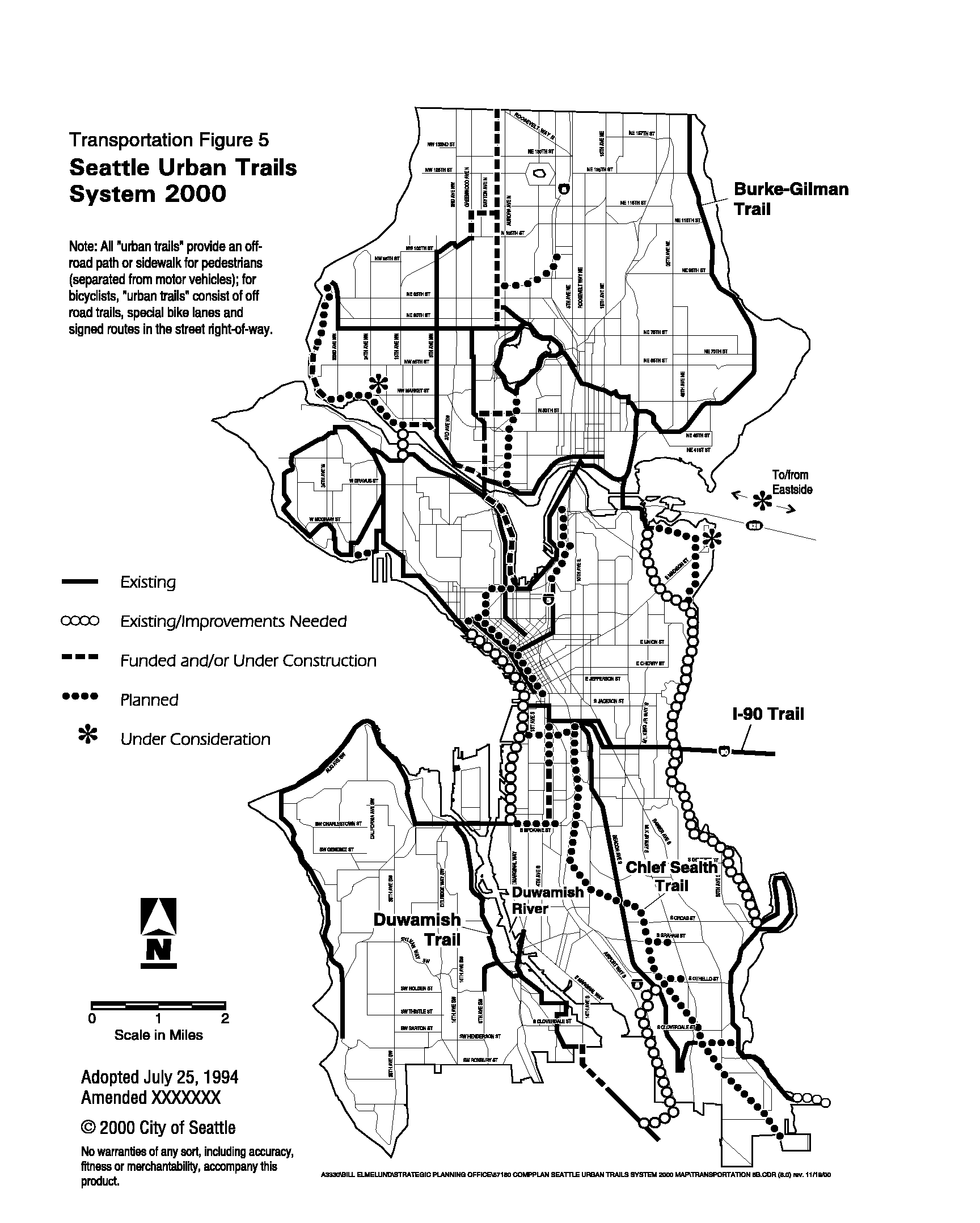
T424 Designate the Urban Trails System as shown in Transportation Figure 5 to facilitate walking and bicycling as viable transportation choices, provide recreational opportunities, and link major parks and open spaces with Seattle neighborhoods. Continue to designate other pedestrian and bicycle street classifications through the Seattle Comprehensive Transportation Program.
T435 Remove barriers to, and create incentives for, walking and bicycling for commuting, errands, other short trips, and recreation.
T446 Integrate pedestrian and bike facilities, services, and programs into both citywide and regional transportation systems where appropriate. Encourage transit providers, the Washington State Ferry System, and others to provide:
T457 Recognize the importance of walking in the city and the contribution walking makes to achieve personal mobility, and environmental objectives, and the sense of community and security. Enhance the pedestrian environment throughout the city.
T468 Through implementation of the comprehensive plan and/or neighborhood planning, dDesignate Key Pedestrian Streets within the highest-density portions of urban villages and along logical connections between villages. Design and operate these streets to be safe and attractive for pedestrians, improve access to transit, encourage street-level activity, and facilitate social interaction. Integrate pedestrian facilities into street improvements on these streets. Consider strategies such as curb bulbs, mid-block crosswalks, pedestrian-activated signals that help pedestrians, benches, street trees, wider sidewalks, lighting, special paving, overhead weather protection, and grade-separated pedestrian walkways over or under major obstacles to pedestrian movement.
T479 Accelerate the maintenance and improvement of existing pedestrian facilities, and develop and maintain new onefacilities throughout the city., in order to Iincrease pedestrian activity, enhance pedestrian safety, and promote a pleasant walking environment. with Give special consideration to certain pedestrian facilities including recommended school walking routes, access to transit, access for people with disabilities, and access to and, within, and between urban villages environments.
T4850 Provide access routes for persons with disabilities and special needs to transit facilities, public facilities, social services, and commercial districts.
T4951 Provide and maintain direct, continuous bicycle routes, and make all appropriate streets bicycle-friendly. Accelerate development of bike facilities in, around, and between urban centers, urban villages, and other key locations. Facilitate bicycling, where appropriate, by techniques such as providing separate trails or bicycle lanes with limited crossings, installing bike-sensitive signals, or designing streets and intersections to accommodate bikes.
T49.552 Develop methods for evaluating the provision and performance of non-motorized travel facilities. These methods should consider:
¨ minimizing delay and discomfort; directness of routes;
¨ continuity of the non-motorized network;
¨ attractiveness of environment;
¨ current and anticipated demand;
¨ barriers to non-motorized transportation, such as terrain, insufficient right-of-way, conflicts with other street uses, lack of sidewalks and paths, and difficult intersections and crossings; and
¨
safety and accessibility for all users, including seniors, children, and persons with disabilitiesled.
These methods should take into account location and surroundings, travel and land use patterns, and environmental constraints. They should be used to monitor the existing facilities, to identify their strengths, deficiencies and potential improvements, and to support development of new and innovative facilities. The methods shall support a process for the allocation of the City’s transportation resources, and facilitate the timely implementation of the comprehensive plan policies for non-motorized travel through both neighborhood planning and general transportation system planning. (New policy added 11/95)
I. MOVING GOODS AND SERVICES
Goals
TG221 Preserve and improve commercial transportation mobility and access.
TG232 Maintain Seattle as the hub for regional goods movement and as a gateway to national and international suppliers and markets.
Discussion: Commercial transportation mobility and access are critical to Seattle's and the region's economic development. Rail service, water transport, truck movement, and air transport are all important for the success of businesses and industries in Seattle and the region. These policies, and those in the economic development element, support existing businesses and industries, and promote Seattle as a place for economic expansion.
Policies
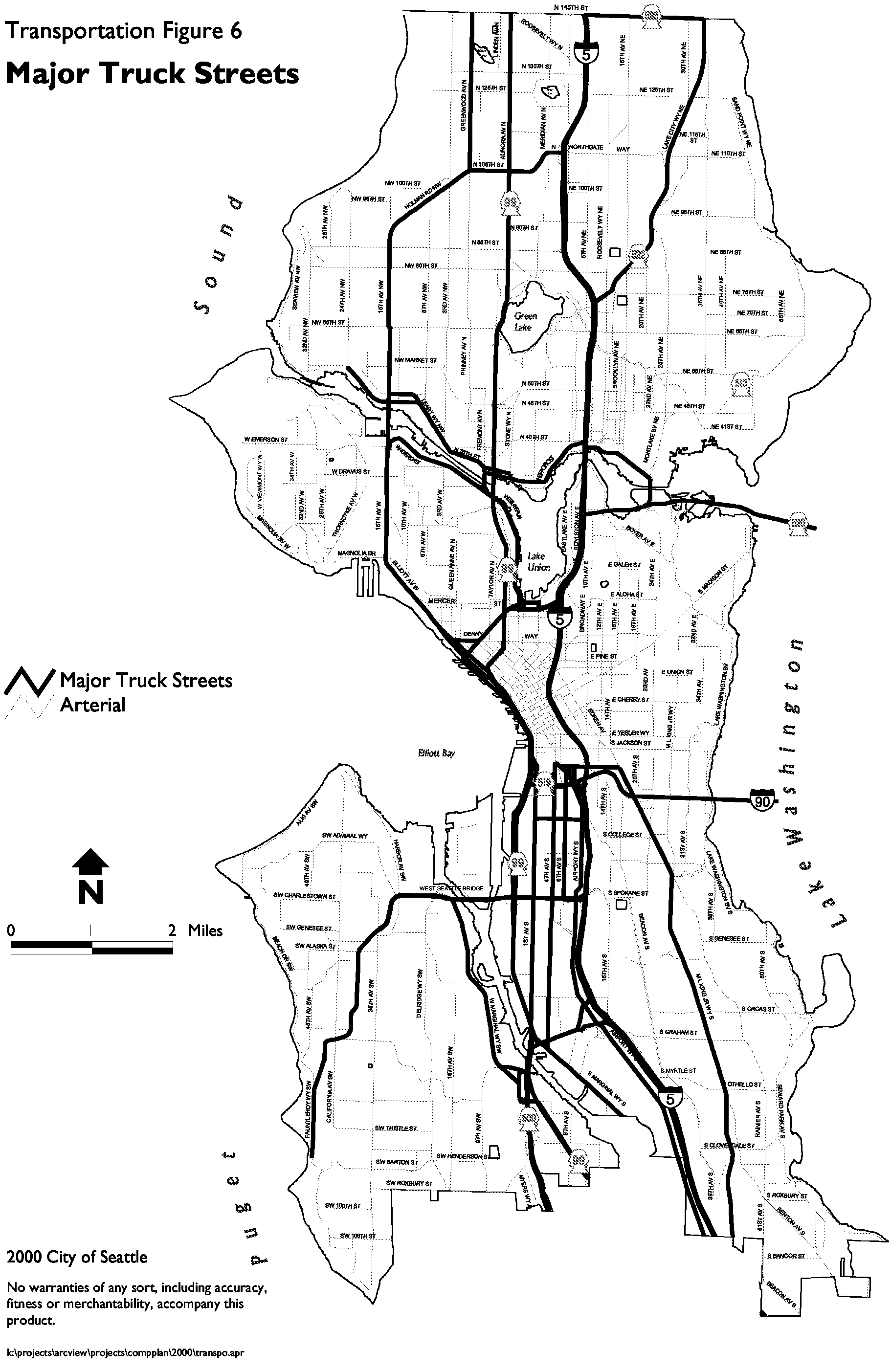
T503 Designate major truck streets as shown in Transportation Figure 6. Monitor these streets and make operating, design, access, and/or service changes, as well as capital investments, to accommodate trucks and to preserve and improve commercial transportation mobility and access on these major truck streets. Continue to designate all other arterials as truck streets, as in the Seattle Comprehensive Transportation Program.
T514 Support the establishment of a public/private freight access consortium to address land-side access needs of Seattle's marine port facilities and manufacturing/industrial centers. Include at least the City, other local jurisdictions, the Port of Seattle, the Washington State Department of Transportation, the Puget Sound Regional Council, private business and residential interests, the railroads, representatives of the trucking industry, and members of the general public.
T525 Support efficient movement of commercial goods by rail where appropriate. Promote continued operation of existing rail lines.
T536 Promote a multi-modal commercial transportation strategy, including rail, trucks, and air and water transport, and advocate for improved freight and goods movement. Work toward improved multi-modal connections among rail yards, the waterfront, the Duwamish, Lake Union, Portage Bay, the ship canal, airports, and regional roadways.
T547 Consider the needs for delivery and collection of goods at local businesses by truck when making street operating decisions, and when developing and implementing projects and programs for highways, streets, and bridges. Consider at least: access to freeways; street width, turning radii, and overhead clearance; railroad crossings; and traffic congestion and conflicts with cars, bicycles, and/or pedestrians.
J. TRANSPORTATION FINANCING
Policies
T558 Emphasize investments for:
T569 Seek funding from various sources and through various strategies, including:
Further, Cconsider pursuing new funding sources including:
Maintain sufficient flexibility to enable the City to take advantage of new funding opportunities and to maximize competitiveness for funding.
T5760 Consider future operating and maintenance costs associated with improvements when making transportation capital investment decisions.
T5861 Coordinate debt financing strategies with other jurisdictions in the region.
MULTI-YEAR FINANCING PLAN
Transportation Figure 7 shows preliminary estimated transportation revenues for the six-year period from 19972001 through 20026, based on the City's past experience, and adjusted to reflect likely future experience.
The preliminary estimates for new revenues in Transportation Figure 7 show the best judgement on likely receipts of revenues from sources that are not certain and with which there is little historical experience. Because this funding would be new, the amounts shown are preliminary, rough estimates. (Section amended 11/96)
Transportation Figure 7
Estimated Future Transportation Revenue
|
Source |
Estimated Revenue 1997-2002 (6 years) (millions) |
|
Grants |
$40-$77 |
|
Gas tax |
$76 |
|
Vehicle License Fee |
$26 |
|
Loans (Public Works Trust Fund) |
$6-$25 |
|
General Fund and Cumulative Reserve Fund (including 1997 Councilmanic bonds) |
$60-$115 |
|
Subtotal |
$208-319 |
|
Preliminary estimates for new revenues: |
|
|
RTA, King County Metro, and/or WSDOT -- for TSM improvements |
$5-$10 |
|
Grants for LINC demonstration project(s) |
$0-5 |
|
1998-2002 local bond or supplementary state funds |
$20-$120 |
|
Subtotal |
$25-$135 |
|
TOTAL (Table amended 11/96) |
$233-$454 |
|
Source |
Estimated Revenue 2001-2006 (6 years) (millions) |
|
Gas tax |
$77 |
|
Vehicle License Fees |
$30 |
|
Grants and Loans (Public Works Trust Fund) |
$90 - $120 |
|
General Fund and Cumulative Reserve Fund |
$203 - $213 |
|
Subtotal |
$401 - $440 |
|
Preliminary estimates for new revenues: |
|
|
Sound Transit, King County Metro, and/or WSDOT -- for TSM improvements |
$5-$7 |
|
2001-2006 New Revenue Source or Supplementary State Funds |
$0 - $54 |
|
Subtotal |
$5 - $61 |
|
TOTAL |
$406 - $501 |
Transportation Figure 8 shows preliminary estimated transportation expenditures for the six-year period from 19972001 through 20026, based on the City's past spending patterns and on the investment policies included in this plan. The distinctions among categories are not hard and fast because, in most cases, an investment listed under one category in fact improves conditions in other categories as well.
The estimated expenditure for the LINC demonstration project(s) is a preliminary, rough estimate based on estimated costs for one or two projects. Because LINC is a new project, and the City has no existing revenue to support it, spending on LINC is contingent on receiving earmarked revenue for the project(s).
The City has also identified other desired transportation investment projects (e.g., Spokane Street viaduct, Mercer corridor, and participation in other regionally significant projects), but no funding has been identified yet and so future spending on these projects is not included in Figure 8.
Transportation Figure 8
Estimated Future Transportation Expenditures
|
Category |
Estimated Expenditures 1997-2002 (6 years) (millions) |
|
Maintenance |
$126-$201 |
|
Safety |
$138-$182 |
|
TSM and trucks/goods movement (capacity utilization) |
$16-$34 |
|
Pedestrians and bicycles |
$18-$37 |
|
Transit priorities |
$10-$25 |
|
LINC demonstration project(s) |
$0-$5 |
|
TOTAL (Table amended 11/96) |
$308-$484 |
|
Category |
Estimated Expenditures 2001-2006 (6 years) (millions) |
|
Operations and Preventative Maintenance |
$172 - $193 |
|
Major Maintenance and Safety |
$179 - $234 |
|
Mobility and Enhancements |
$55 - $73 |
|
TOTAL |
$406 - $501 |
ANALYSIS
Based on the revenue and expenditure estimates shown in Transportation Figures 7 and 8, the City expects to have sufficient resources to fund the expenditure needs shown.
If probable funding falls short, then the Budget Office of Management and Planning and the Seattle Transportation Department will be directed to:
¨ Identify and evaluate possible additional funding resources; and/or
¨ Identify and evaluate alternative land use and transportation scenarios, including assumptions about levels and distribution of population and employment, densities, types and mixes of land use, and transportation facilities and services, and assess their effects on transportation funding needs.
The City may then revise the Comprehensive Plan as warranted to ensure that level-of-service standards will be met. (Section Amended 11/96)