![[HOME]](/netaicon/homeicon.gif)
![[SEARCH]](/netaicon/srchpage.gif)

![[CURR_LIST]](/netaicon/curlist.gif)


![[BOTTOM]](/netaicon/bottom.gif)
![[HELP]](/netaicon/help.gif)
Seattle City Council Bills and Ordinances
Information modified on June 14, 2011; retrieved on June 19, 2026 1:44 AM
Ordinance 123543
Introduced as Council Bill 116985
Title | |
|---|---|
Description and Background | |
|---|---|
| Current Status: | Passed |
| Fiscal Note: | Fiscal Note to Council Bill No. 116985 |
| Index Terms: | LAND-USE-CODE, SAND-POINT, MAGNUSON-PARK, LAND-USE-REGULATIONS, PARKS, LAND-USE-PLANNING, PARKS |
| References: | |
Legislative History | |
|---|---|
| Sponsor: | BAGSHAW |
| Date Introduced: | October 4, 2010 |
| Committee Referral: | Parks and Seattle Center |
| City Council Action Date: | February 22, 2011 |
| City Council Action: | Passed |
| City Council Vote: | 9-0 |
| Date Delivered to Mayor: | February 23, 2011 |
|
Date Signed by Mayor: (About the signature date) | February 28, 2011 |
| Date Filed with Clerk: | February 28, 2011 |
| Signed Copy: | PDF scan of Ordinance No. 123543 |
Text | |
|---|---|
|
ORDINANCE ____________________ AN ORDINANCE relating to land use and zoning and signs in the Seattle Municipal Code amending Sections 23.55.014 and 23.72.004 and adding a new Section 23.55.032 relating to signs within the Sand Point Overlay District. WHEREAS, in 1997 the City Council passed Ordinance 118624 creating the Sand Point Overlay District ("Overlay District") to guide reuse of properties and buildings from the former Naval Air Station Sand Point, and to integrate the property into the City of Seattle as a multi-purpose regional center that provides expanded opportunity for recreation, education, arts, cultural, and community activities, increased public access to the shoreline and enhanced open space and natural areas, opportunities for affordable housing and community and social services, and expanded opportunity for low-impact economic development uses; and WHEREAS, the Overlay District allows for non-residential uses that are not normally permitted in the underlying residential zones, but are permitted due to the unique nature of the district, and which permitted uses were most recently updated in 2008 by Ordinance 122829, which did not include any updates to existing sign standards appropriate for this district; and WHEREAS, in 2004 the City hired a consultant to develop a signage and wayfinding master plan for Warren G. Magnuson Park ("Magnuson Park"), in which the Overlay District is located, that included an inventory and analysis of existing signs and a separate public review process, which resulted in a Final Signage and Wayfinding Master Plan governing commercial and non-commercial signs for the entire Magnuson Park, all of which are unique to the Overlay District; and WHEREAS, the current underlying single-family and multifamily zones within the Overlay District do not adequately regulate signs for permitted uses in the Overlay District, which includes park area and uses, multifamily uses in new and historic structures, and historic industrial and office buildings that now house educational, environmental, and cultural organizations that are not generally permitted in the underlying zones; and WHEREAS, this unique combination of uses and historic structures in the Overlay District requires sign standards that are different from the types of signage allowed for residential or commercial uses that are found outside of the Overlay District, as well as for other parks within those residential zones, to balance the City's interests in aesthetics, safety, and communication; and WHEREAS, the need to modify the existing regulations for signs within the Overlay District has increased significantly as buildings have been renovated and new public and private commercial uses have been located within the Overlay District; and WHERAS, the buildings within the Overlay District are oriented toward streets and rights-of-way internal to Magnuson Park and the Overlay District and not towards Sand Point Way NE, the main arterial abutting the Overlay District, and have made wayfinding for the mix of uses allowed in the Overlay District problematic; and WHEREAS, the new regulations for signs in the Overlay District will allow for greatly improved visitor wayfinding once visitors enter the Overlay District off of Sand Point Way NE; and WHEREAS, the purposes of the Sign Code are to regulate commercial signs and to protect the public interests in avoiding driver distraction and visual blight caused by signs, while allowing needed communication with the public through signs that invite rather than demand the public's attention, and encouraging the use of signs that enhance the visual environment of the city; NOW, THEREFORE, BE ORDAINED BY THE CITY OF SEATTLE AS FOLLOWS: Section 1. Subsections 23.55.014A and B of the Seattle Municipal Code, which subsections were last amended by Ordinance 121477, are amended as follows: 23.55.014 Off-premises signs A. Advertising Signs. 1. No advertising sign shall be erected, or constructed, unless an existing advertising sign is relocated or reconstructed at a new location. An advertising sign may be relocated or reconstructed if: a. The existing advertising sign was lawfully erected and after the effective date of the ordinances codified in this section, is registered to pursuant to subsection F of this section;
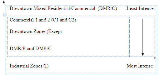
b. The advertising sign is located on a site or in a zone where it is not permitted, except as provided in subsection A.1.c of this (( c. In each calendar year one advertising sign which is located on a site or in a zone where it is permitted may be relocated or reconstructed if a citizen submits a written request for relocation to the Director; d. The reconstructed or relocated advertising sign will be a permitted use and will conform with all ordinances of the City at its new location; e. The construction permit for the relocated or reconstructed advertising sign is issued during the pendency of the demolition permit for the existing sign; f. The advertising sign face does not increase in size; and g. The advertising sign is relocated to an area with the same or more intensive zoning. Areas in which advertising signs are allowed are listed below from least intense to most intense zoning, and zones listed on the same line are considered of the same intensity. Zones which do not allow advertising signs shall be considered less intense zones for the purpose of relocation. This list is for purposes of this criterion only.
h. The number of relocated advertising signs does not exceed 2. For purposes of relocation, sign owners maintain the right to relocation. 3. Wall signs cannot be relocated.
4. Maximum Sign Face Area. The maximum total area of any advertising sign in Commercial 1 and 2, Industrial and Downtown (except Downtown Mixed Residential/Commercial) zones shall be ((
5. All advertising signs shall be located at least (( 6. No variances shall be permitted from the provisions of this subsection A.
B. Off-premises Directional Signs. The maximum area of any off-premises directional sign shall be (( Section 2. A new Section 23.55.032 of the Seattle Municipal Code is added as follows: 23.55.032 Signs in the Sand Point Overlay District. A. Sign regulations within this section apply to subareas B and C in the Sand Point Overlay District, as described in Section 23.72.004 and depicted on Map A for Section 23.72.004. Sign regulations in the underlying zones continue to apply to all uses in subarea A. The regulations in this Section 23.55.032 supersede the sign regulations for the underlying zone in subareas B and C, except when a residential use is allowed in subarea B the sign regulations for the underlying zone in that subarea shall apply. B. Signs in the Sand Point Historic District portion of the Sand Point Overlay District subareas B and C, as depicted in Map B for Section 23.72.004, are permitted when consistent with the provisions of this section and undertaken in a manner consistent with the Sand Point Historic Properties Reuse and Protection Plan, dated April 1998, or successor plans, as documented by a letter of approval from the Sand Point Historic Preservation Coordinator, or any successor agency decision maker, certifying that the erection of the proposed sign is consistent with the plan. C. Signs shall be stationary and shall not rotate. D. The following types of signs are prohibited: 1. Flashing image signs; 2. Signs with changing-images; 3. Message board signs; or 4. Off-premises signs, except as provided in subsection 23.55.032.G. E. Signs may be externally illuminated, or nonilluminated, except as provided in subsection 23.55.032.G. Electric signs that include individually cut letters, numbers, or figures are permitted when affixed to a building or structure, except as provided in subsection 23.55.032.G. For any use located on a lot in subarea B, when located within 50 feet of an abutting lot in subareas A or C, permitted electrical or externally illuminated signs are required to be oriented so that no portion of the sign face is visible from: 1. an existing or permitted principal structure on the abutting lot in subarea A; or 2. an existing or permitted principal structure on the abutting lot in subarea C, unless the use of the structure is a non-conforming use at the time of the effective date of this ordinance. F. On-Premises Signs. 1. The following on-premises signs are permitted in addition to the signs permitted by subsections 23.55.032.F.2 and F.3: a. Memorial signs or tablets, and the names of buildings and dates of building erection when cut into a masonry surface or constructed of bronze or other noncombustible materials, up to a maximum of 5 square feet; b. Signs for public facilities indicating danger and/or providing service or safety information; c. National, state, county, city and institutional flags. In addition, flags are permitted for a non-profit organization not meeting the definition of an Institution in Seattle Municipal Code Section 23.84. 2. The number and type of on-premises signs allowed for business establishments in subarea B and subarea C of the Sand Point Overlay District are as follows: a. Each individual business establishment is permitted one projecting sign oriented to pedestrians on each building facade occupied by that business on public rights-ofway and publicly-owned roadways. The maximum area of this sign is 16 square feet. b. Each individual business establishment is permitted one of the following types of signs for each 300 linear feet, or portion thereof, of building facade occupied by that business establishment on public rights-of-way and publicly-owned roadways. These signs are: i. wall; ii. ground; iii. projecting; iv. awning; v. canopy; vi. marquee, or vii. under-marquee. The maximum area for any of these signs is 48 square feet each. The sign shall be located on the portion of the structure that is on the public right-of-way or publicly owned roadway and occupied by the business establishment. c. A business establishment with more than 300 linear feet of a building facade on a public right-of-way or publicly owned roadway is permitted to have one additional sign of the type permitted under subsection 23.55.032.F.2.b. A business establishment that is permitted to have two signs under this subsection 23.55.032.F.2.c may combine the two signs into one of the type of signs permitted under subsection 23.55 032.F.2.b, up to a maximum total combined area of 96 square feet. d. Sign Height. (1) The maximum height for any portion of a pedestrian oriented projecting sign permitted under subsection 23.55.032F.2.a is 10 feet above existing grade. (2) The maximum height for any portion of a projecting sign that is not a pedestrian oriented sign permitted under subsection 23.55.032.F.2.a is 50 feet above existing grade, or the height of the top of the wall, excluding any cornice, of the structure to which the sign is attached, whichever is less. (3) The maximum height for any portion of a wall, awning, canopy, marquee, or under-marquee sign is 20 feet or the height of the top of the wall, excluding any cornice of the structure to which the sign is attached, whichever is greater. 3. Multifamily structures in subarea C of the Sand Point Overlay District are allowed to have identification signs as follows: a. One identification sign is permitted on each facade of a building containing a multifamily use on public rights-of-way and publicly-owned roadways. Such signs may not be located within 50 feet of each other. b. Identification signs may be wall, ground, projecting, awning, canopy, marquee, or under-marquee. c. The maximum area of each identification sign is 24 square feet. d. The maximum height for any portion of a wall, projecting, awning, canopy, marquee, or under-marquee identification sign is 20 feet or the height of the top of the wall, excluding any cornice, whichever is greater. G. Off-Premises Signs. Two types of off-premises signs are allowed in the Sand Point Overlay District: "Off-premises directional signs", and "Sand Point District signs." 1. "Off-premises directional signs" are allowed, subject to the provisions in subsection 23.55.032.G.3. The maximum area for each off-premises directional sign face is 24 square feet per sign face. Only Sand Point Overlay District property owners may install off-premises directional signs. 2. "Sand Point District signs" are signs installed by Sand Point Overlay District property owners listing the names of buildings or subareas and the organizations and businesses located within those buildings or subareas. Sand Point District signs are allowed in lieu of business district identification signs, which are prohibited. The maximum area for each off-premises Sand Point District sign is 48 square feet per sign face. The maximum area for any portion of a Sand Point District sign that lists an individual business or other nonresidential use is 16 square feet per sign face. 3. Off-premises directional signs and Sand Point District signs are allowed as follows: a. Signs permitted under this subsection 23.55.032.G shall be ground signs; b. The provisions of subsection 23.55.014.B do not apply; and c. If a Sand Point District sign lists more than one individual business or other nonresidential use, the overall area devoted to such messages shall be at least 8 square feet smaller than the part of the sign identifying the name of the building or the subarea; d. The signs shall comply with subsections 23.55.014 E.1.a, dispersion standards for directional sign faces and business district identification signs, 23.55.014 E.2, no roof signs, 23.55.014 E.3, lighting, and 23.55.014 E.4, height. Subsection 23.55.014 E.1.b does not apply. I. Sign kiosks are allowed as provided in subsections 23.55.015 B, C, D and E. J. Signs shall conform to Section 23.55.016, Light and glare from signs. Section 3. Maps A and B for Section 23.72.004, which were adopted by Ordinance 122829, are amended as follows: 23.72.004 Sand Point Overlay District established.
There is hereby established pursuant to Chapter 23.59 of the Seattle Municipal Code, the Sand Point Overlay District, including three subareas : Map A for 23.72.004 -Sand Point Overlay District Map A for 23.72.004-Sand Point Overlay District Map B for 23.72.004 -Naval Station Puget Sound Sand Point Historic District Map B for 23.72.004 -Naval Station Puget Sound Sand Section 4. This ordinance shall take effect and be in force 30 days from and after its approval by the Mayor, but if not approved and returned by the Mayor within ten days after presentation, it shall take effect as provided by Municipal Code Section 1.04.020. Passed by the City Council the ____ day of _____________________, 2011, and signed by me in open session in authentication of its passage this _____ day of ____________________, 2011. _________________________________ President __________of the City Council Approved by me this ____ day of ___________________, 2011. _________________________________ Michael McGinn, Mayor Filed by me this ____ day of ______________________, 2011. ___________________________________ City Clerk (Seal) Nathan Torgelson/Michael Jenkins DPR Sand Point Sign Code Amendments ORD Feburary 3, 2011 Version #20 |
|
Attachments |
|---|
![[TOP]](/netaicon/toppg.gif)