![[HOME]](/netaicon/homeicon.gif)
![[SEARCH]](/netaicon/srchpage.gif)

![[CURR_LIST]](/netaicon/curlist.gif)


![[BOTTOM]](/netaicon/bottom.gif)
![[HELP]](/netaicon/help.gif)
Seattle City Council Bills and Ordinances
Information modified on July 1, 2009; retrieved on July 26, 2026 7:34 AM
Ordinance 122738
Introduced as Council Bill 116248
Title | |
|---|---|
| AN ORDINANCE relating to environmentally critical areas, amending Sections 22.802.020, 23.47A.012, 23.47A.013, 23.54.020, 25.09.015, 25.09.020, 25.09.030, 25.09.055, and 25.09.520, and adding a new Section 25.09.110 of the Seattle Municipal Code to designate and regulate Peat Settlement-prone Geologic Hazard Areas. | |
Description and Background | |
|---|---|
| Current Status: | Passed |
| Fiscal Note: | Fiscal Note to Council Bill No. 116248 |
| Index Terms: | LAND-USE-PERMITS, LAND-USE-CODE, ENVIRONMENTAL-PROTECTION, FLOODS, NATURAL-EVENTS CONSTRUCTION, PERMITS, BUILDING-CODEs, DRAINAGE, FLOOD-CONTROL-AND-DRAINAGE, SURFACE-WATER |
Legislative History | |
|---|---|
| Sponsor: | CONLIN |
| Date Introduced: | June 16, 2008 |
| Committee Referral: | Environment, Emergency Management and Utilities |
| City Council Action Date: | July 14, 2008 |
| City Council Action: | Passed |
| City Council Vote: | 8-0 (Excused: Clark) |
| Date Delivered to Mayor: | July 15, 2008 |
|
Date Signed by Mayor: (About the signature date) | July 23, 2008 |
| Date Filed with Clerk: | July 23, 2008 |
| Signed Copy: | PDF scan of Ordinance No. 122738 |
Text | |
|---|---|
|
AN ORDINANCE relating to environmentally critical areas, amending Sections 22.802.020, 23.47A.012, 23.47A.013, 23.54.020, 25.09.015, 25.09.020, 25.09.030, 25.09.055, and 25.09.520, and adding a new Section 25.09.110 of the Seattle Municipal Code to designate and regulate Peat Settlement-prone Geologic Hazard Areas. WHEREAS, peat-rich soils are prone to settlement, and therefore, development in areas underlain by, or in the vicinity of peat-rich soils may impact nearby parcels, and WHEREAS, the Department of Planning and Development (DPD) has followed the Guidelines adopted by the Washington State Department of Community Trade and Economic Development, and in consideration of the Growth Management Act, as set out in the Best Available Science Report for Peat Settlement-prone Areas, attached as Exhibit B; and WHEREAS, DPD has prepared regulations for development in areas with peat-rich soils in consideration of the public interest, and has met with affected communities in and around mapped peat deposits. NOW, THEREFORE, BE IT ORDAINED BY THE CITY OF SEATTLE AS FOLLOWS: Section 1. Subsection A of Section 22.802.020 of the Seattle Municipal Code, which Section was last amended by Ordinance 119965, is amended as follows: 22.802.020 Drainage control review and application requirements. A. Thresholds for Drainage Control Review. Drainage control review and approval shall be required for any of the following: 1. Standard drainage control review and approval shall be required for the following: a. Any land disturbing activity encompassing an area of seven hundred fifty (750) square feet or more; b. Applications for either a master use permit or building permit that includes the cumulative addition of seven hundred fifty (750) square feet or more of land disturbing activity and new and replaced impervious surface; c. Applications for which a grading permit or approval is required; d. Applications for street use permits for the cumulative addition of seven hundred fifty(750) square feet or more of new and replaced impervious surface and land disturbing activity after the effective date of the ordinance codified in this subtitle; e. City public works project or construction contracts, including contracts for day labor and other public works purchasing agreements, for the cumulative addition of seven hundred fifty (750) square feet or more of new and replaced impervious surface and land disturbing activity to the site after the effective date of the ordinance codified in this subtitle, except for projects in a City-owned right-of-way and except for work performed for the operation and maintenance of park lands under the control or jurisdiction of the Department of Parks and Recreation;
f. Permit approvals and contracts that include any new or replaced impervious surface on a site deemed a potentially hazardous location, as specified in Section 22.800.050; g. Permit approvals that include any new impervious surface in a Category I peat settlement-prone area delineated pursuant to Section 25.09.020; or
2. Large project drainage control review and approval shall be required for projects that include: a. Five thousand (5,000) square feet or more of new or replaced impervious surface; or b. One (1) acre or more of land disturbing activity.
3. The City may, by interagency agreement signed by the Directors of SPU and *** Section 2. Subsection A of section 23.47A.012 of the Seattle Municipal Code, which Section was last amended by Ordinance 122311, is amended as follows: 23.47A.012 Structure height. A. Maximum Height. The height limit for structures in NC zones or C zones is thirty (30) feet, forty (40) feet, sixty-five (65) feet, eighty-five (85) feet, one hundred twenty-five (125) feet, or one hundred sixty (160) feet, as designated on the Official Land Use Map, Chapter 23.32. Structures may not exceed the applicable height limit, except as otherwise provided in this section. Within the South Lake Union Urban Center, any modifications or exceptions to maximum structure height are allowed solely according to the provisions of the Seattle Mixed Zone, subsections 23.48.010 B1-3, D and E, and not according to the provisions of this section. 1. In zones with a thirty (30) foot or forty (40) foot mapped height limit, except in the South Lake Union Urban Center: a. the height of a structure may exceed the otherwise applicable limit by up to four (4) feet, subject to subsection A1c of this section, provided the following conditions are met: (1) Either (a) A floor-to-floor height of thirteen (13) feet or more is provided for nonresidential uses at street level; or (b) A residential use is located on a street-level, street facing facade, and the first floor of the structure at or above grade is at least four (4) feet above sidewalk grade; and (2) The additional height allowed for the structure will not allow an additional story beyond the number that could be built under the otherwise applicable height limit. b. The height of a structure may exceed the otherwise applicable limit by up to seven (7) feet, subject to subsection A1c of this section, provided all of the following conditions are met: (1) Residential and multipurpose retail sales uses are located in the same structure; (2) The total gross floor area of at least one (1) multi-purpose retail sales use exceeds twelve thousand (12,000) square feet; (3) A floor-to-floor height of sixteen (16) feet or more is provided for the multi-purpose retail sales use at street level; (4) The additional height allowed for the structure will not allow an additional story beyond the number that could be built under the otherwise applicable height limit if a sixteen (16) foot floor-to-floor height were not provided at street level; and (5) The structure is not allowed additional height under subsection A1a of this section. c. The Director shall reduce or deny the additional structure height permitted by this subsection A1 if the additional height otherwise would significantly block views from neighboring residential structures of any of the following: Mount Rainier, the Olympic and Cascade Mountains, the downtown skyline, Green Lake, Puget Sound, Lake Washington, Lake Union and the Ship Canal. 2. For any lot within the designated areas shown on Map 23.47A.012 A, the maximum structure height in NC zones or C zones with a forty (40) foot height limit may be increased to sixty-five (65) feet, provided that all portions of the structure above forty (40) feet contain only residential uses, and provided that no additional height is allowed under subsection A1 of this section. 3. Monorail transit facilities may exceed the height limit of the zone according to the provisions of Section 23.80.004 or Section 15.54.020. 4. Within the South Lake Union Urban Center, maximum structure height shall be determined according to the provisions of the Seattle Mixed Zone, Section 23.48.010. 5. Within the Station Area Overlay District within the University District Northwest Urban Center Village, maximum structure height may be increased to one hundred twenty-five (125) feet when all of the following are met: a. The lot is within two (2) blocks of a planned or existing light rail station; b. The proposed use of the lot is functionally related to other office development, permitted prior to 1971, to have over five hundred thousand (500,000) square feet of gross floor area to be occupied by a single entity; c. A transportation management plan for the life of the use includes incentives for light rail and other transit use by the employees of the office use; d. The development shall provide street level amenities for pedestrians and shall be designed to promote pedestrian interest, safety, and comfort through features such as landscaping, lighting and transparent facades, as determined by the Director; and e. This subsection can be used only once per functionally related development. 6. On a lot containing a peat settlement-prone environmentally critical area, the height of a structure may exceed the otherwise applicable height limit and the other height allowances provided by this section by up to three (3) feet. In addition, three (3) more feet of height may be allowed for any wall of a structure on a sloped lot, provided that on the uphill side(s) of the structure, the maximum elevation of the structure height shall be no greater than the height allowed by the first sentence of this subsection A6 (Exhibit 23.47A.012 A). The Director may apply the allowances in this subsection A6 only if the following conditions are met:
a. The Director finds that locating a story of parking underground is infeasible due to physical site conditions such as a high water table;
b. The Director finds that the additional height allowed for the structure is necessary to accommodate parking located partially below grade that extends no more that six (6) feet above existing or finished grade and no more than three (3) feet above
the highest existing or finished grade along the structure footprint, whichever is lower, as measured to the finished floor level above; and
c. Other than the additional story of parking allowed pursuant to this subsection A6, the additional height allowed for the structure by this subsection A6 will not allow an additional story beyond the number of stories that could be built under the
otherwise applicable height limit. *** Section 3. Subsections A and D of section 23.47A.013 of the Seattle Municipal Code, which Section was last amended by Ordinance 122311, is amended as follows: 23.47A.013 Floor area ratio. A. Floor area ratio (FAR) limits apply to all structures and lots in all NC zones and C zones. 1. All gross floor area not exempt under subsection D of this Section is counted against the maximum gross floor area allowed by the permitted FAR. 2. When there are multiple structures on a lot, the highest FAR limit applicable to any structure on the lot applies to the combined non-exempt gross floor area of all structures on the lot, subject to subsection A4 of this section. 3. Above-grade parking within or covered by a structure or portion of a structure must be included in gross floor area calculations, except as provided in subsection D6. 4. When a lot is in more than one zone, the FAR limit for each zone applies to the portion of the lot located in that zone. *** D. The following floor area is exempt from calculation of gross floor area subject to FAR limits: 1. All gross floor area below existing or finished grade, whichever is lower; 2. Gross floor area of a transit station, including all floor area open to the general public during normal hours of station operation but excluding retail or service establishments to which public access is limited to customers or clients, even where such establishments are primarily intended to serve transit riders; 3. Within the South Lake Union Urban Center, gross floor area occupied by mechanical equipment located on the roof of a structure; 4. Within the South Lake Union Urban Center, mechanical equipment that is accessory to a research and development laboratory, up to fifteen (15) percent of the gross floor area of a structure. The allowance is calculated on the gross floor area of the structure after all space exempt under this subsection is deducted; and 5. Within the First Hill Urban Center Village, on lots zoned NC3, with a one hundred and sixty (160) foot height limit, all gross floor area occupied by a residential use.
6. On a lot containing a peat settlement-prone environmentally critical area, above-grade parking within or covered by a structure or portion of a structure where the Director finds that locating a story of parking below grade is infeasible due
to physical site conditions such as a high water table, if either:
a. the above-grade parking extends no more that six (6) feet above existing or finished grade and no more than three (3) feet above the highest existing or finished grade along the structure footprint, whichever is lower, as measured to the finished
floor level or roof above, as depicted in Exhibit 23.47A.012A; or
b. all of the following conditions are met:
(1) no above-grade parking is exempted by subsection D6a
(2) the parking is accessory to a residential use on the lot;
(3) total parking on the lot does not exceed 1 space for each residential dwelling unit plus the number of spaces required by this Code for non-residential uses; and
(4) the amount of gross floor area exempted by this subsection D6b does not exceed twenty-five (25) percent of the area of the lot in zones with a height limit less than sixty-five (65) feet, or fifty (50) percent of the area of the lot in zones with a
height limit sixty-five (65) feet or greater. *** Section 4. Section 23.54.020 of the Seattle Municipal Code, which section was last amended by Ordinance 122311, is amended to add a new subsection K as follows: 23.54.020 Parking quantity exceptions. The parking quantity exceptions set forth in this section apply in all zones except downtown zones, which are regulated by Section 23.49.019, and Major Institution zones, which are regulated by Section 23.54.016. * * * K. Peat Settlement-prone Environmentally Critical Areas. Except in Single-family, Residential Small Lot, and Lowrise zones, the Director may reduce or waive the minimum accessory off-street parking requirements to the minimum extent necessary to offset underground parking potential lost to limitations set forth in Section 25.09.110 on development below the annual high static groundwater level in peat settlement-prone areas. In making any such reduction or waiver, the Director will assess area parking needs. The Director may require a survey of onand off-street parking availability. The Director may take into account the level of transit service in the immediate area; the probable relative importance of walk-in traffic; proposals by the applicant to encourage carpooling or transit use by employees; hours of operation; and any other factor or factors considered relevant in determining parking impact. Section 5. Subsection A of Section 25.09.015 of the Seattle Municipal Code, which Section was last amended by Ordinance 122370, is amended as follows: 25.09.015 Application of chapter A. This chapter applies to any development, as defined in Section 25.09.520, or platting carried out by any person on publicly or privately owned parcels containing an environmentally critical area or buffer, except that parcels that are solely within seismic or
volcanic hazards areas, as defined in Sections 25.09.020.A. Section 6. Section 25.09.020 of the Seattle Municipal Code, which Section was last amended by Ordinance 122370, is amended as follows: 25.09.020 Environmentally critical areas definitions. The following are environmentally critical areas designated by this chapter: geologic hazard areas, steep slope areas, flood-prone areas, wetlands, fish and wildlife habitat conservation areas, and abandoned landfills. A. Geologic Hazard Areas and Steep Slope Areas.
1. Geologic hazard areas are liquefaction-prone areas, landslide-prone areas, peat settlement-prone areas, seismic hazards areas and volcanic hazard areas described in subsections 2, 3, 5,
areas. Steep slope areas that are regulated for additional erosion hazards are described in subsection 4. 2. Liquefaction-prone Areas. Liquefaction-prone areas are areas typically underlain by cohesionless soils of low density, usually in association with a shallow groundwater table, that lose substantial strength during earthquakes. 3. Landslide-prone Areas. The following are landslide-prone areas: a. Known landslide areas identified by documented history, or areas that have shown significant movement during the last ten thousand (10,000) years or are underlain by mass wastage debris deposited during this period; or b. Potential landslide areas: (1) Those areas that are described as potential slide areas in "Seattle Landslide Study" (Shannon & Wilson, 2000 and 2003) (2) Areas with indications of past landslide activity, such as landslide headscarps and sidescarps, hummocky terrain, areas with geologic conditions that can promote earth movement, and areas with signs of potential landsliding, such as springs, groundwater seepage, and bowed or backtilted trees. (3) Areas with topographic expression of runout zones, such as fans and colluvial deposition at the toes of hillsides. (4) Setbacks at the top of very steep slopes or bluffs, depending on soil conditions. (5) Slopes with an incline of forty (40) percent or more within a vertical elevation change of at least ten feet (10'). For the purpose of this definition, a slope is measured by establishing its toe and top and averaging the inclination over at least ten feet (10') of elevation difference. Also for the purpose of this definition: (a) The "toe" of a slope means a distinct topographic break in slope that separates slopes inclined at less than forty percent (40%) from slopes inclined at forty percent (40%) or more. Where no distinct break exists, the "toe" of a slope is the lower-most limit of the area where the ground surface drops ten feet (10') or more vertically within a horizontal distance of twenty-five feet (25'); and (b) The "top" of a slope is a distinct topographic break in slope that separates slopes inclined at less than forty percent (40%) from slopes inclined at forty percent (40%) or more. Where no distinct break exists, the "top" of a slope is the upper-most limit of the area where the ground surface drops ten feet (10') or more vertically within a horizontal distance of twenty-five feet (25'). (6) Areas that would be covered under one of subsections (2) to (5), but where the topography has been previously modified through the provision of retaining walls or non-engineered cut and fill operations; (7) Any slope area potentially unstable as a result of rapid stream incision or stream bank erosion. 4. Steep Slope Areas. Steep slope areas are areas with a slope described in subsection A3b(5) above; provided that when such a slope is on a parcel in a Downtown zone or highrise zone, the area is designated only as a landslide prone area.
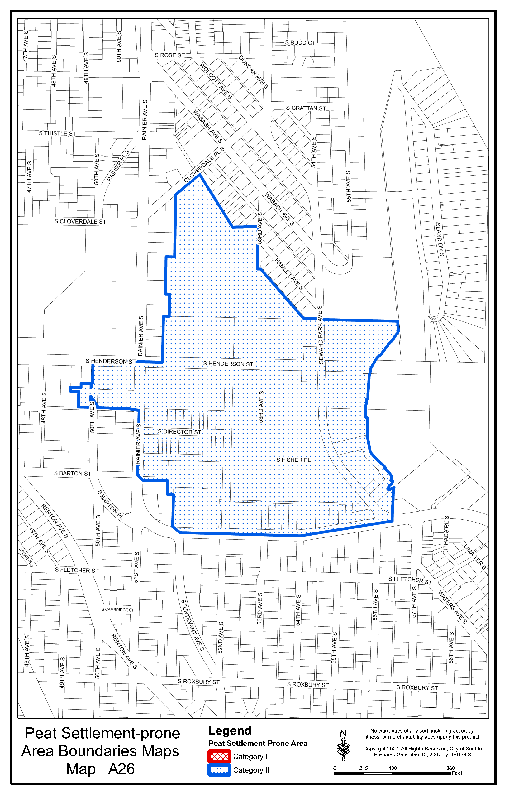
5. Peat Settlement-prone Areas.
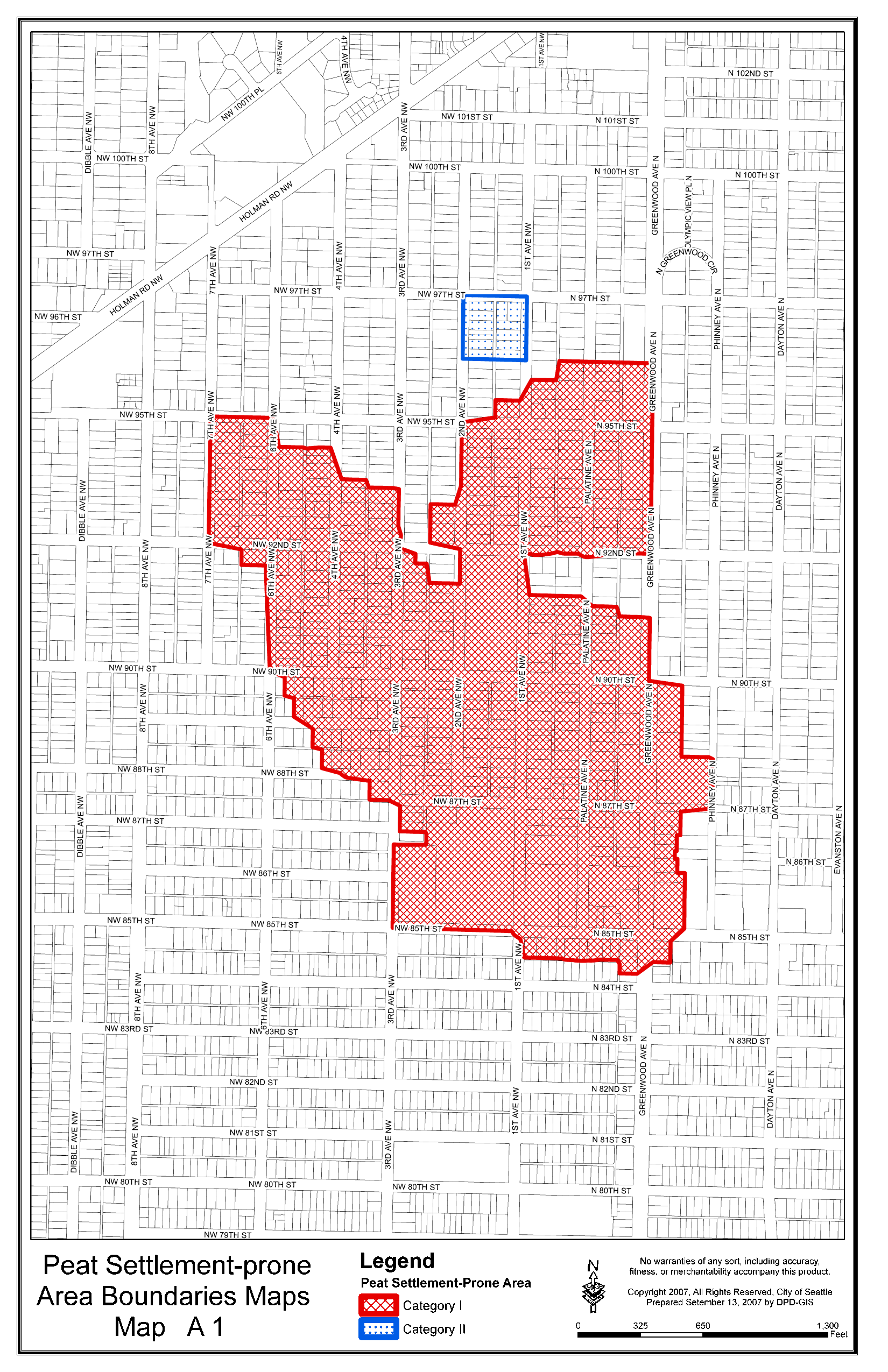
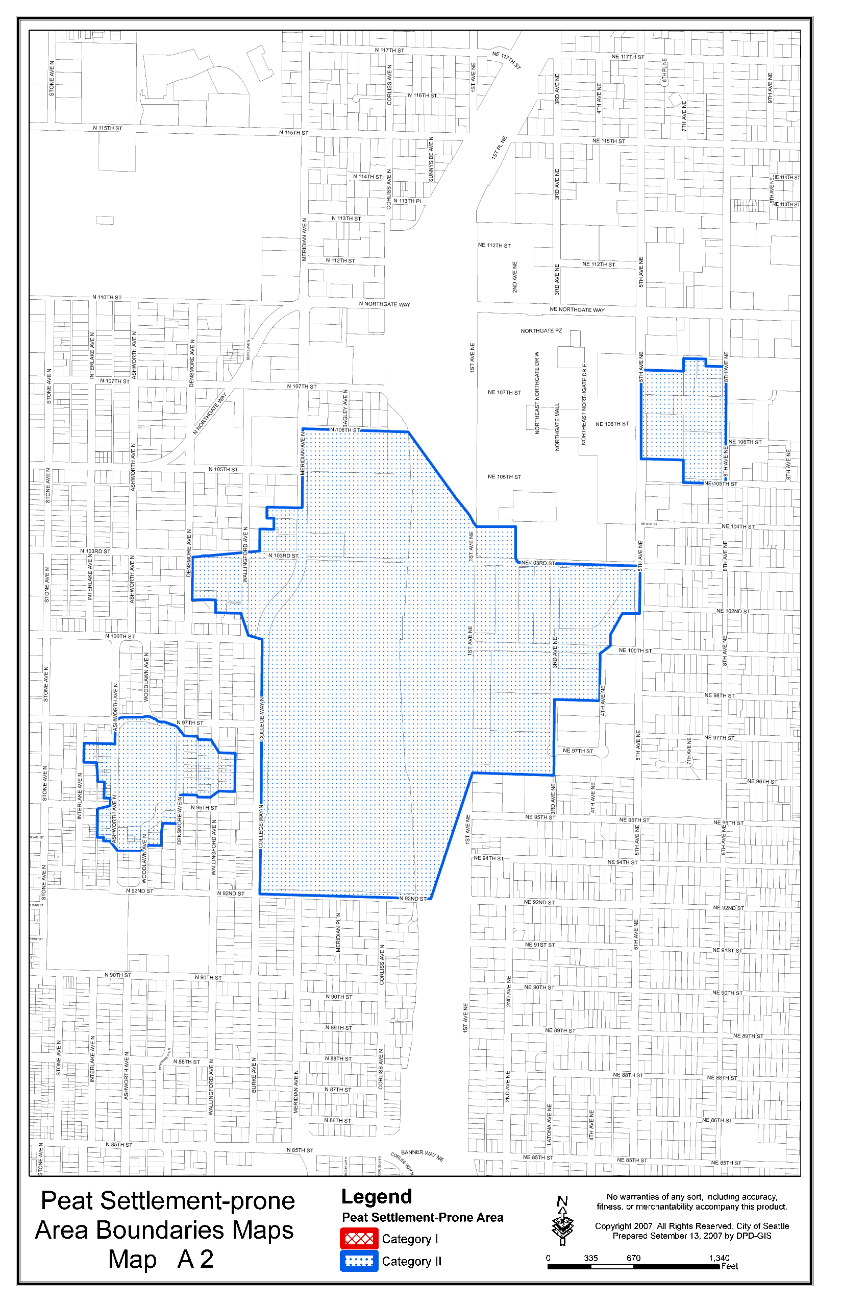
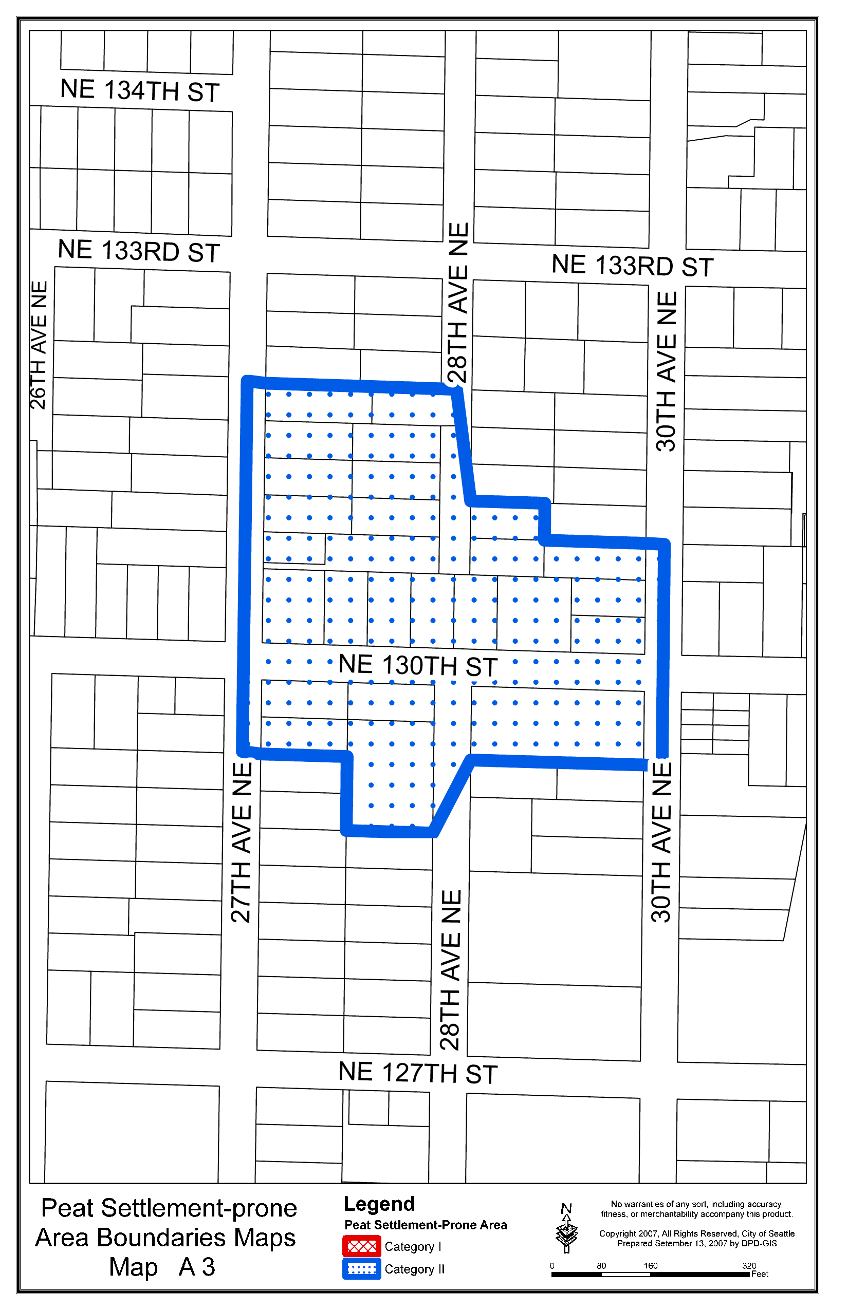
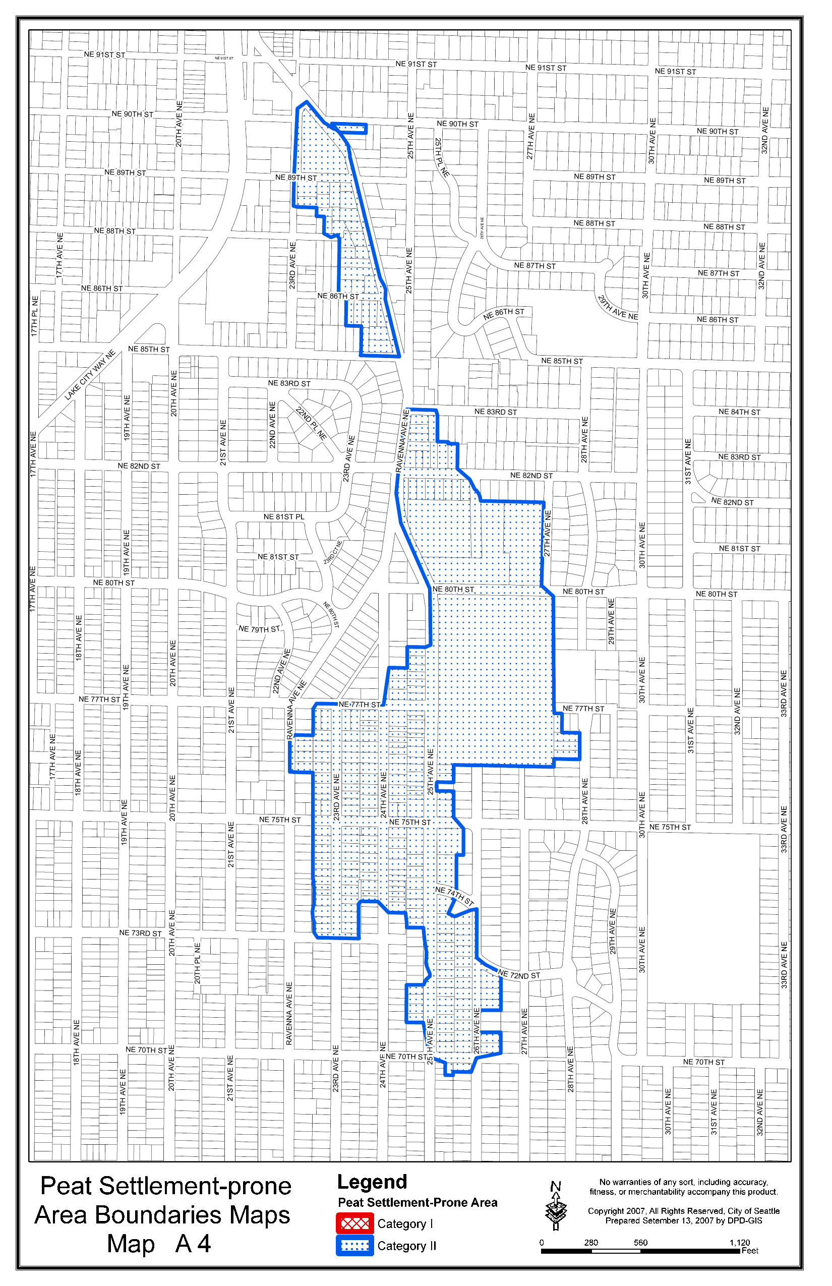
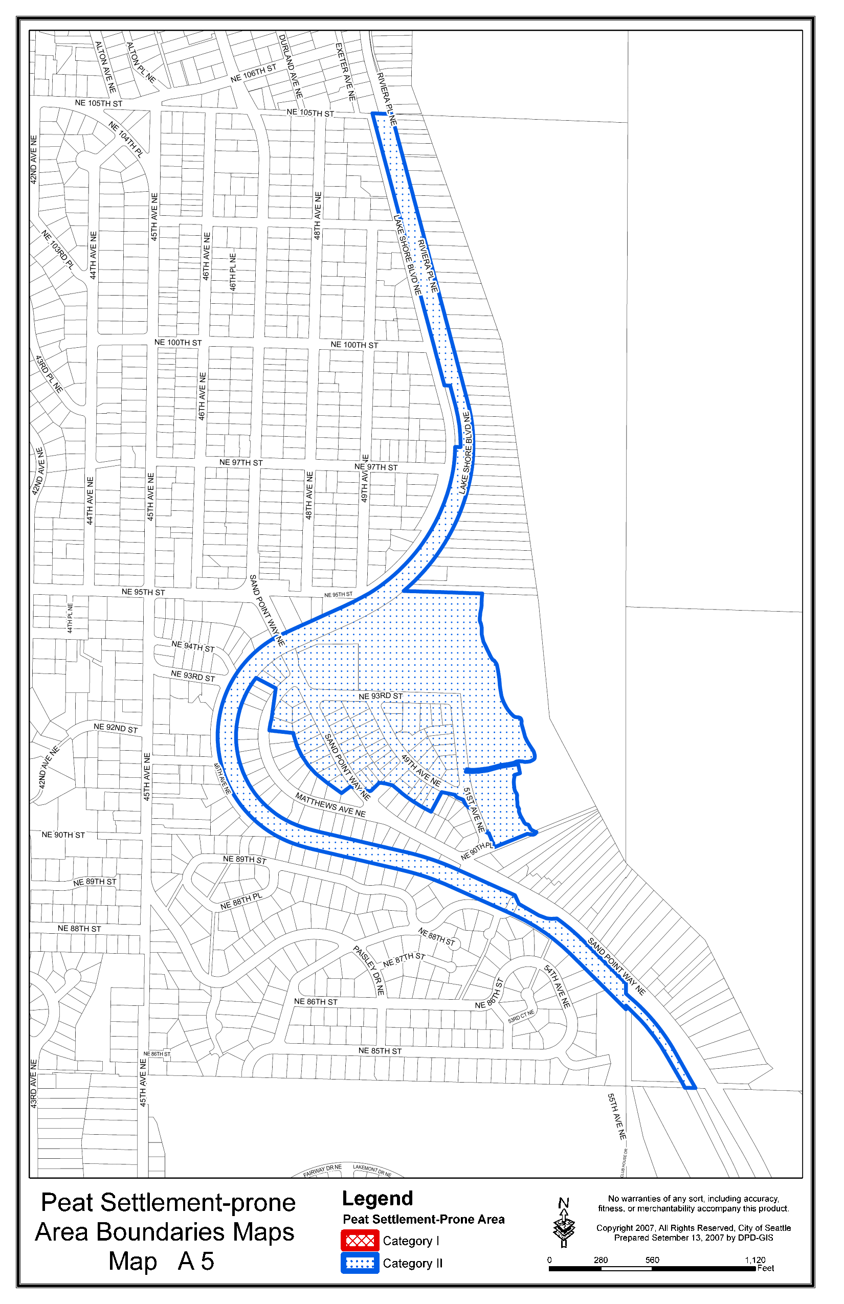
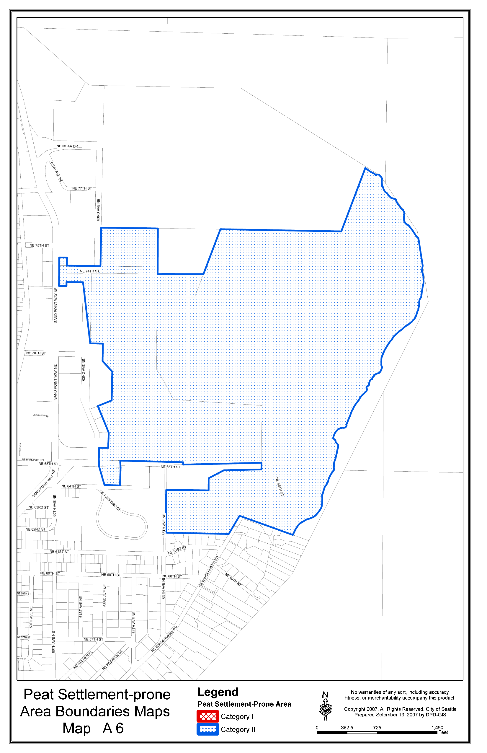
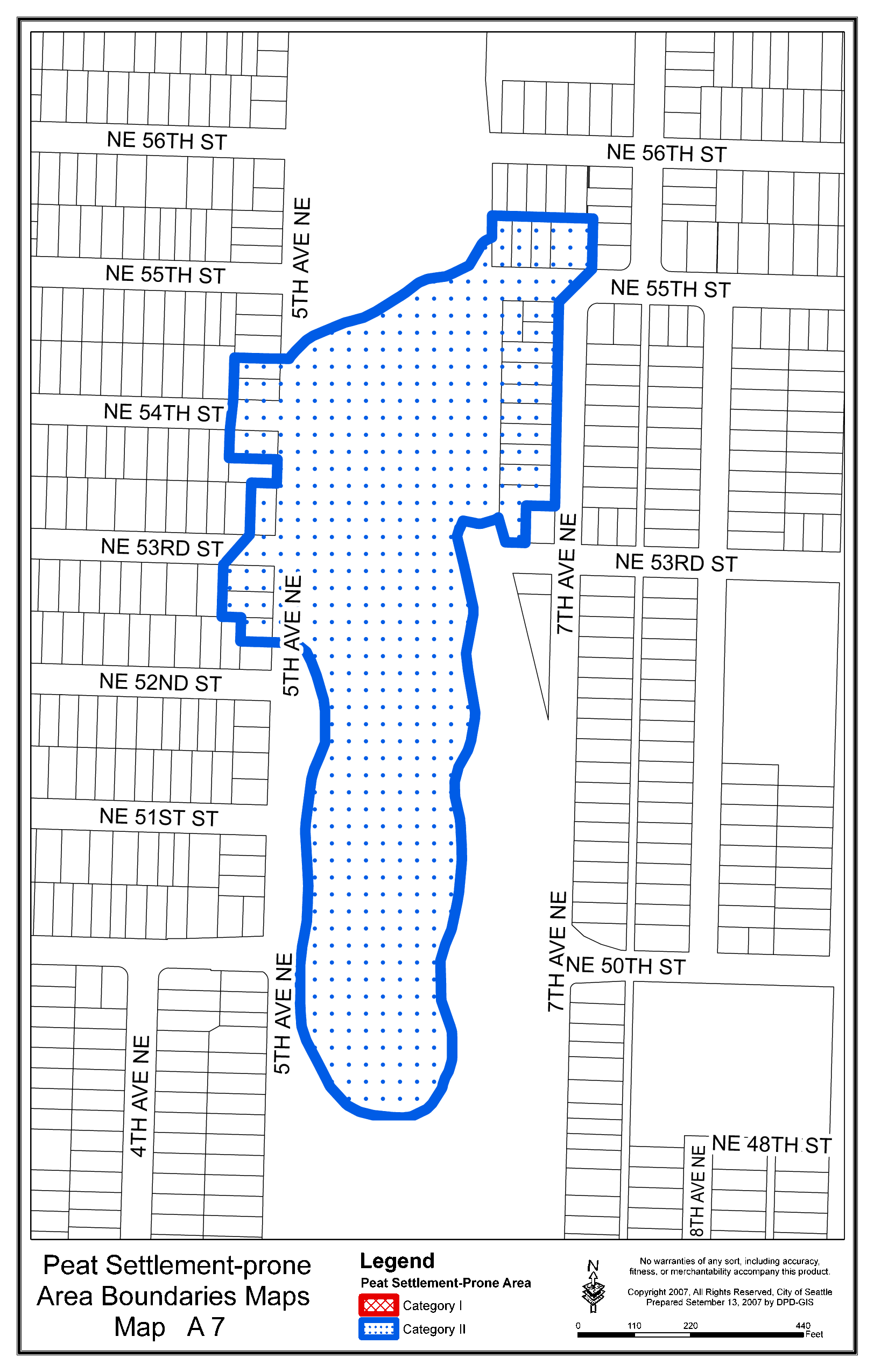
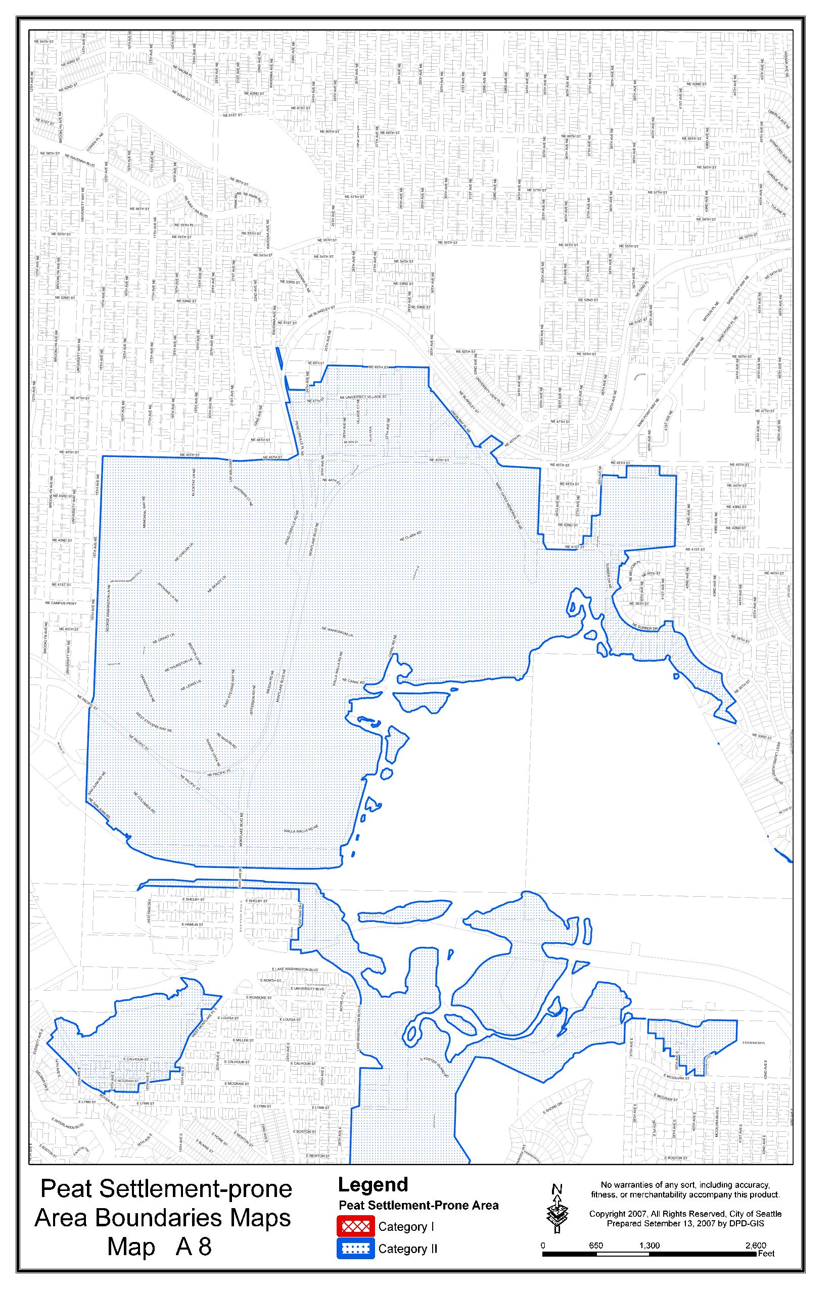
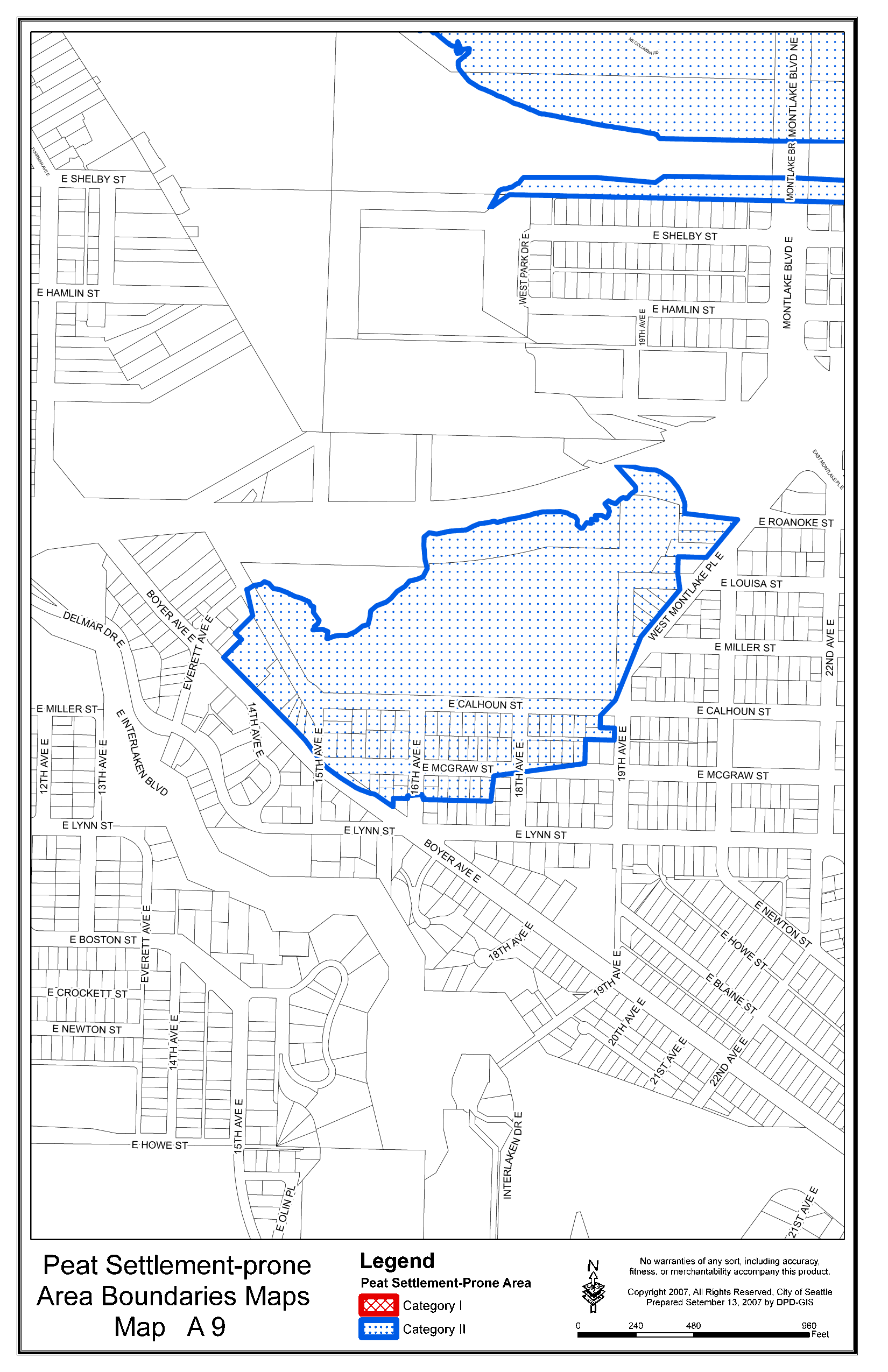
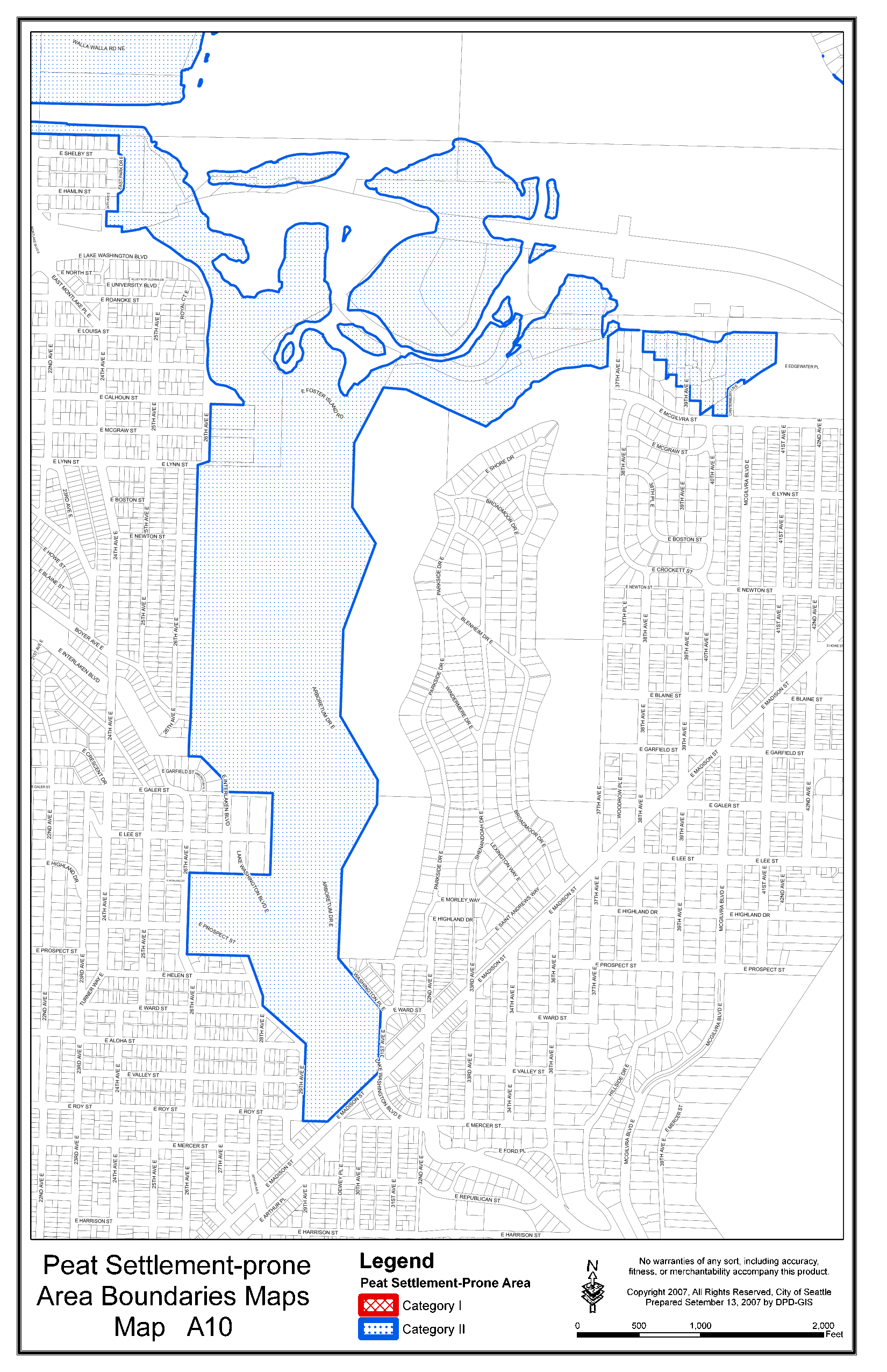
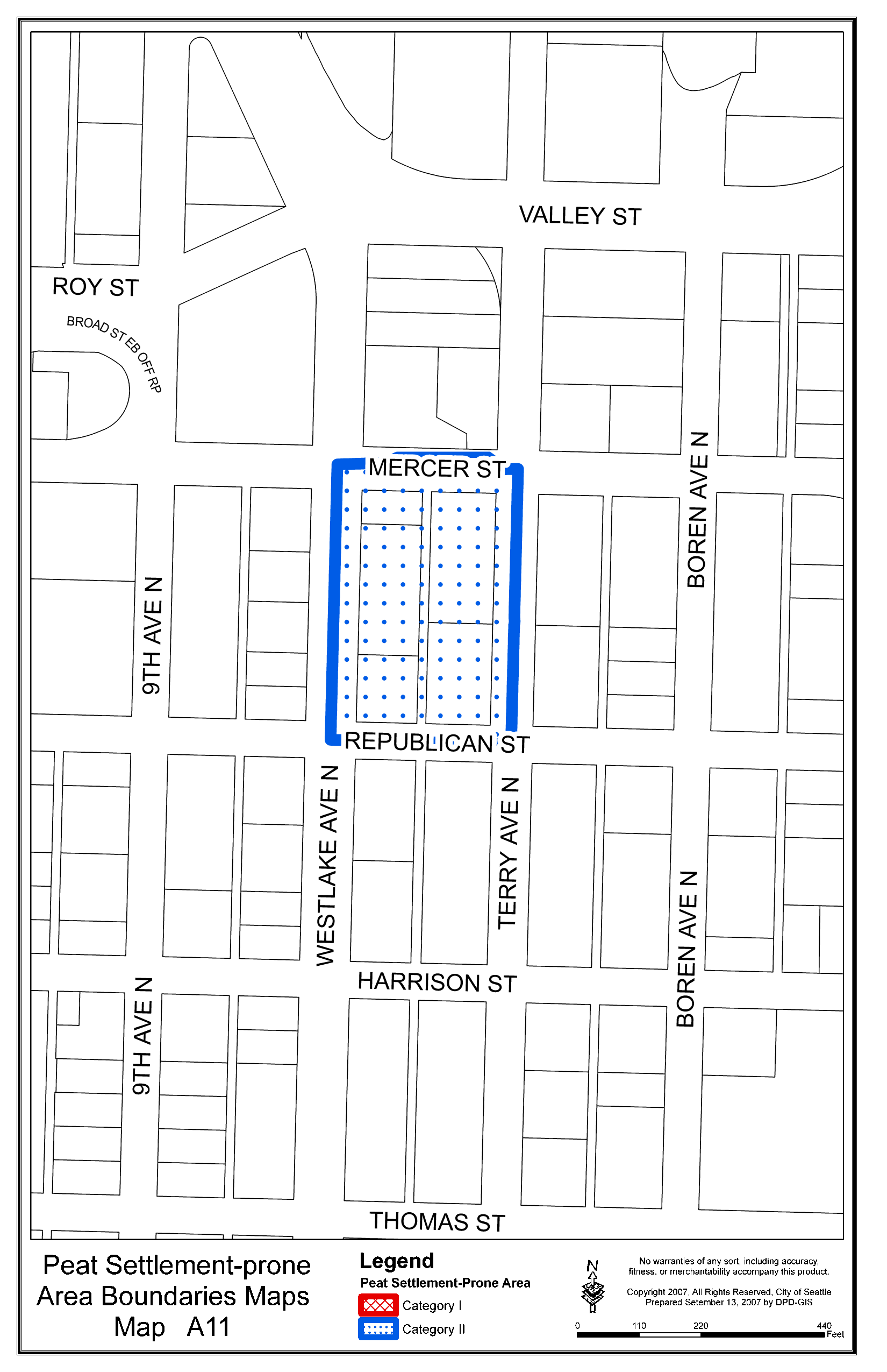
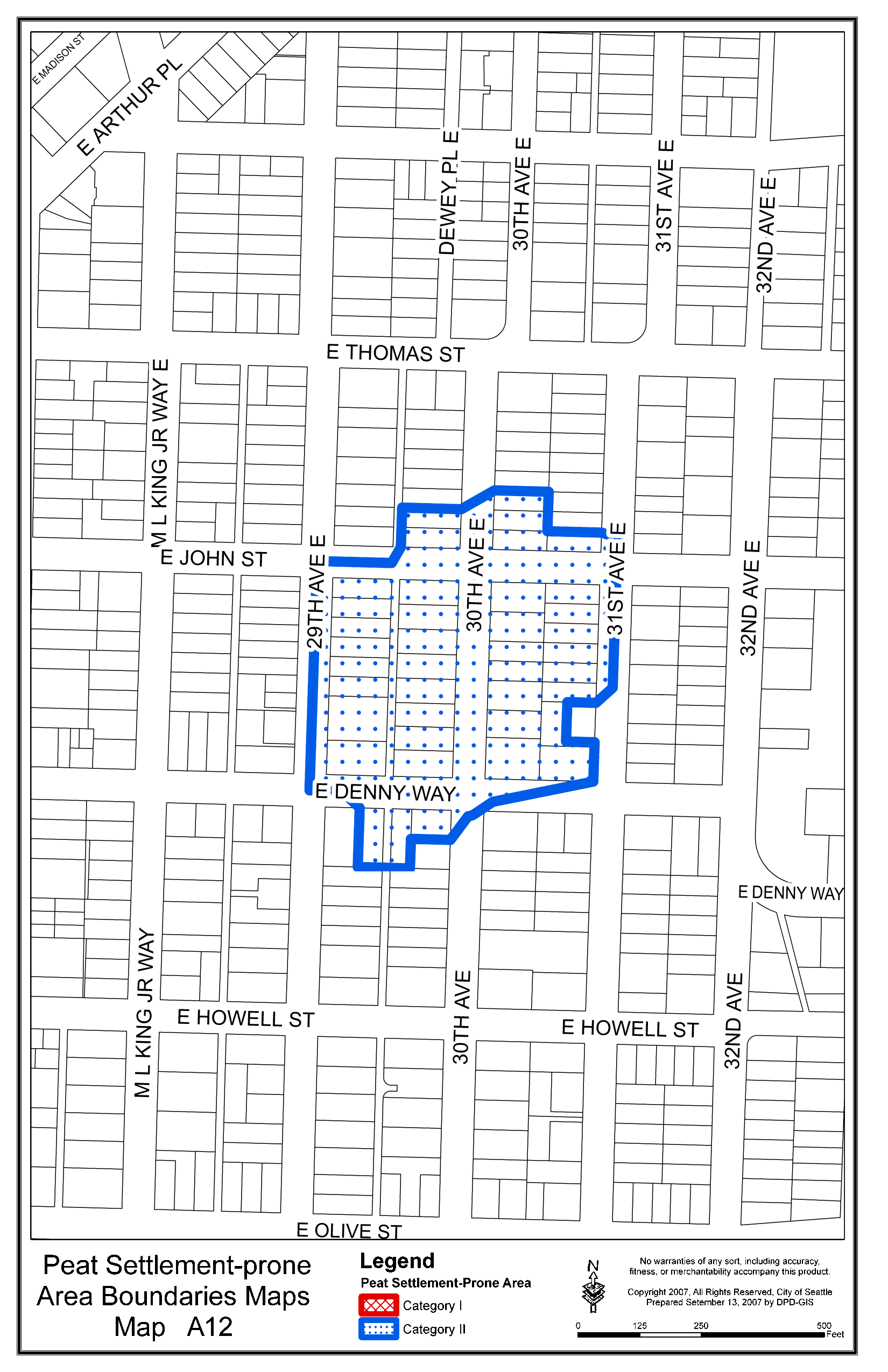
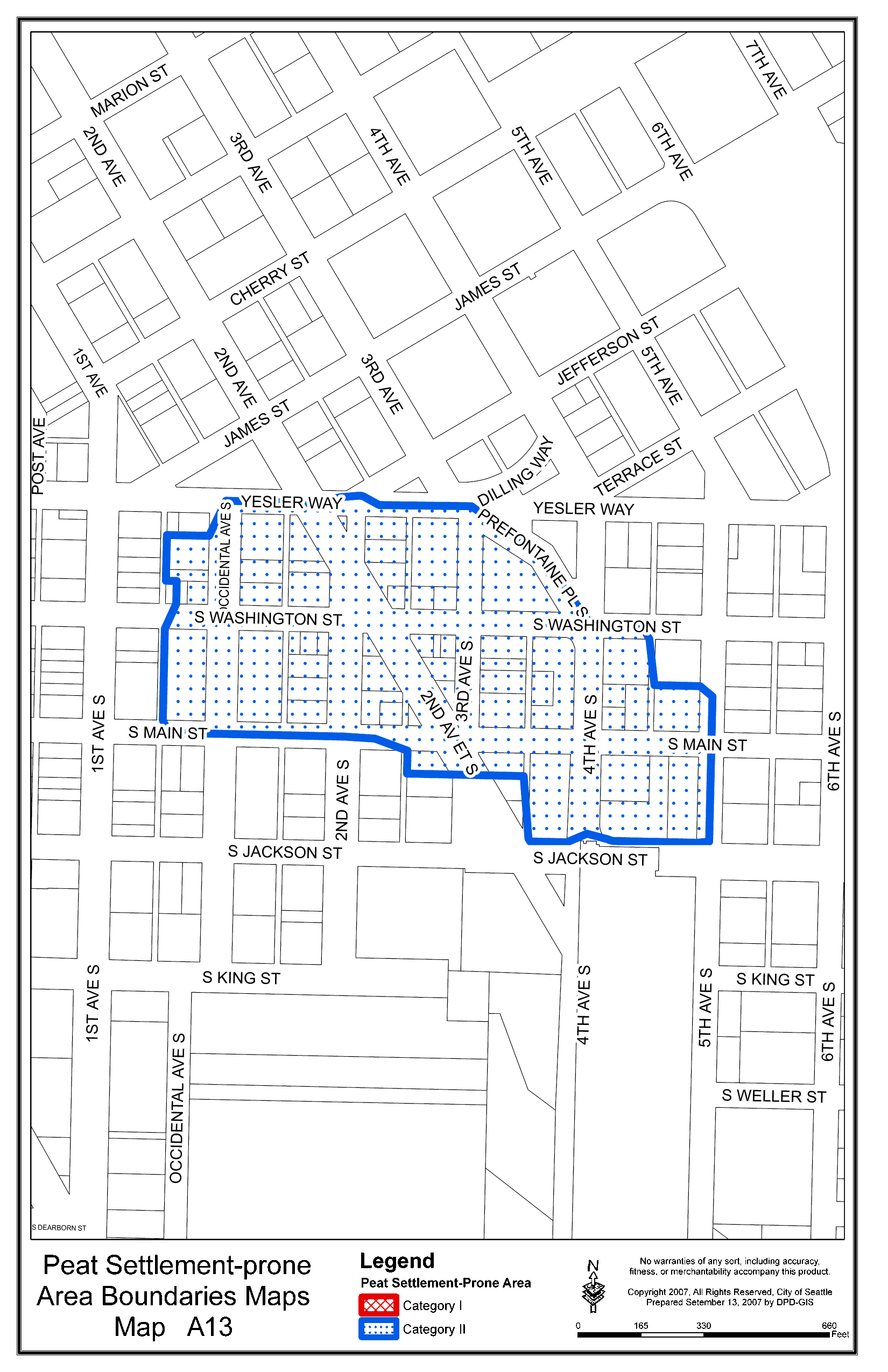
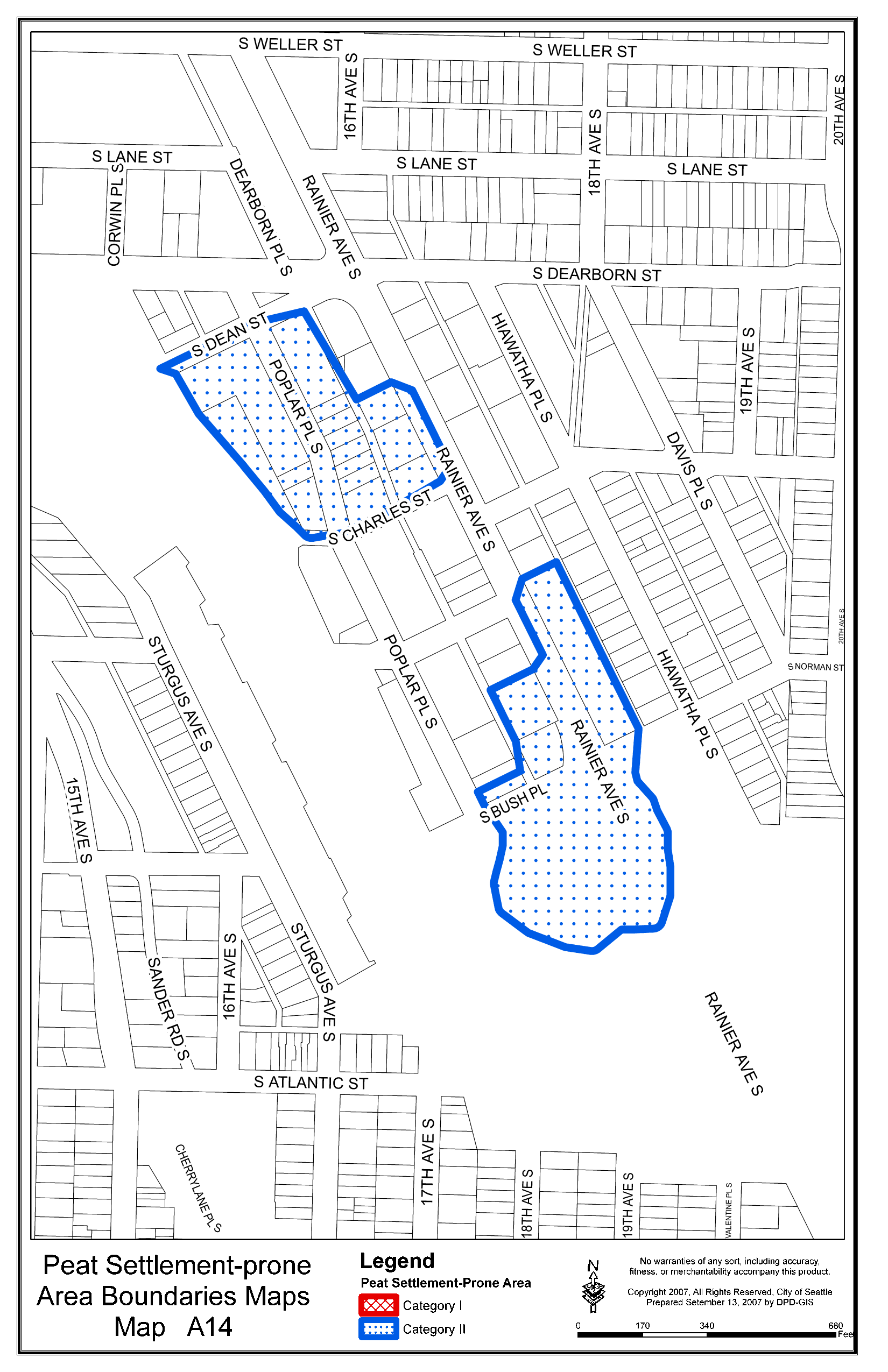
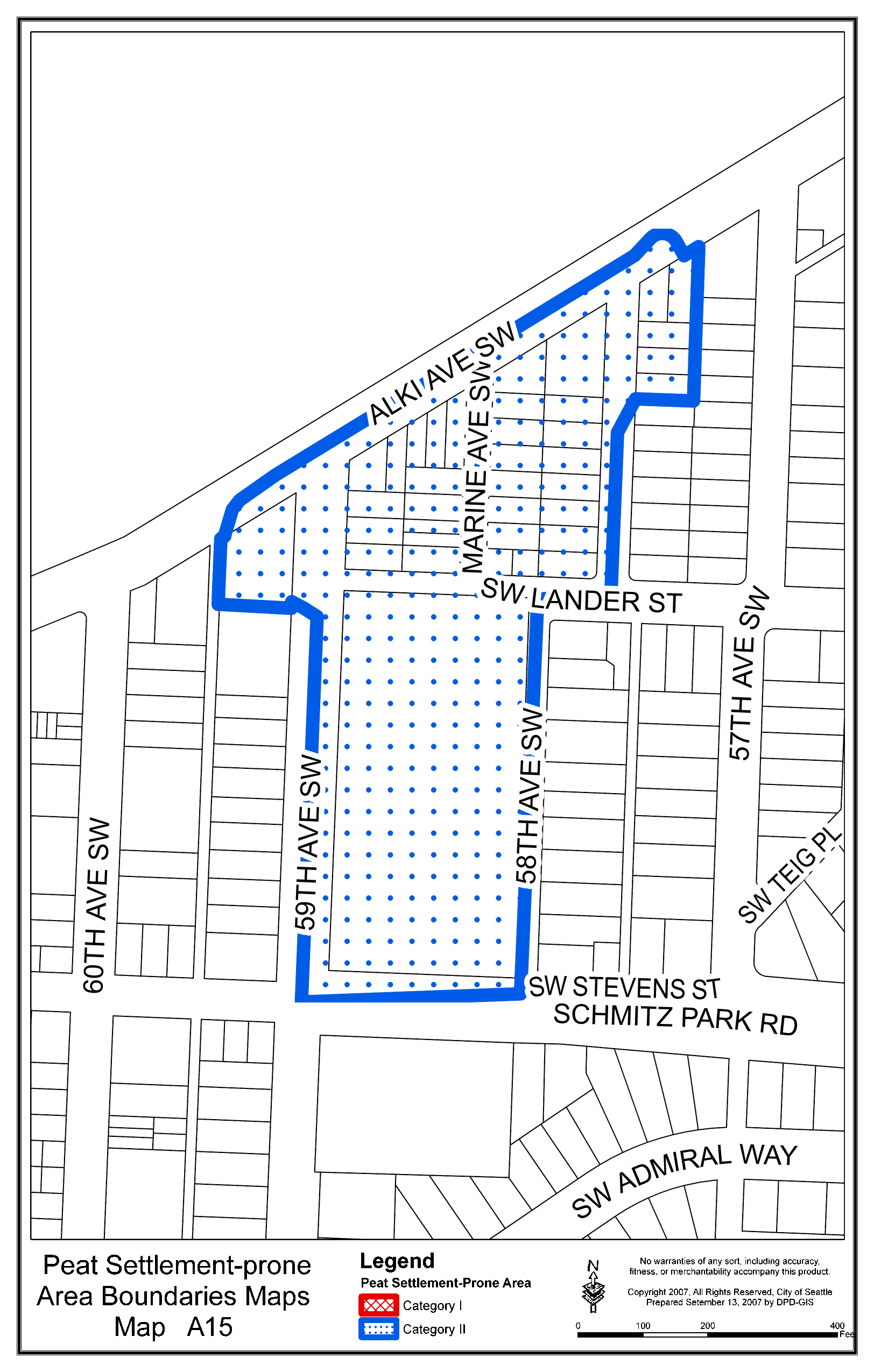
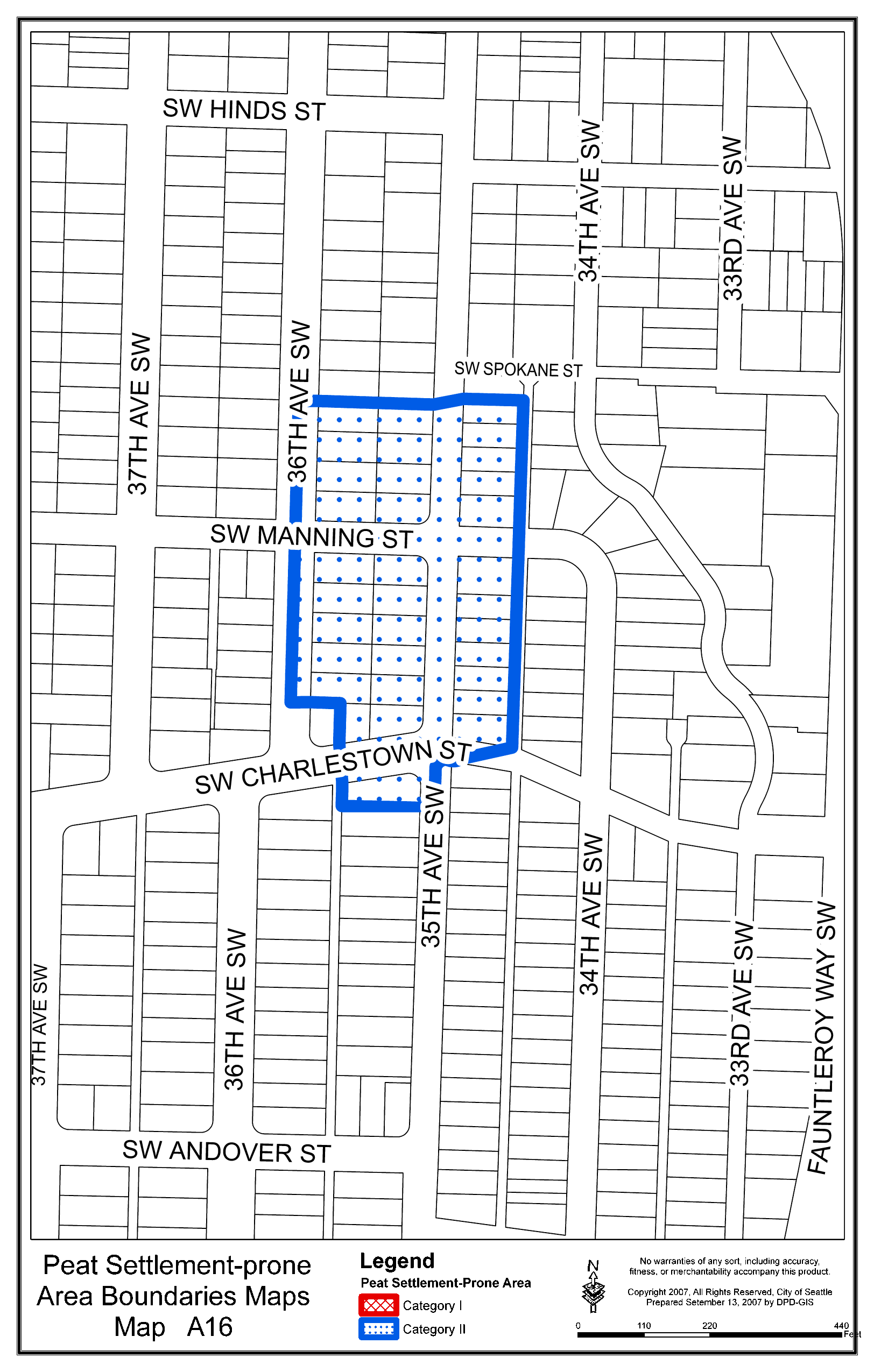
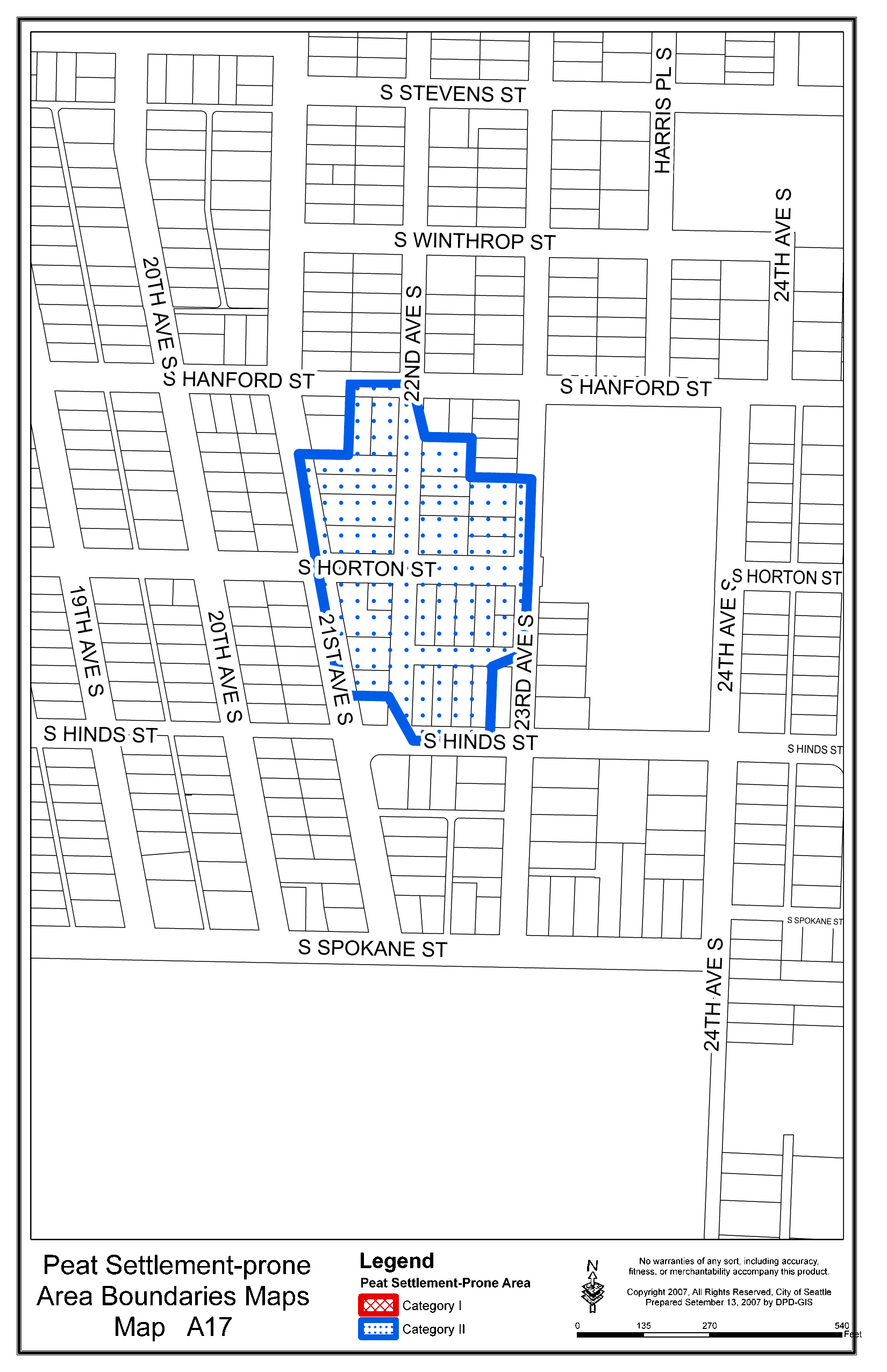
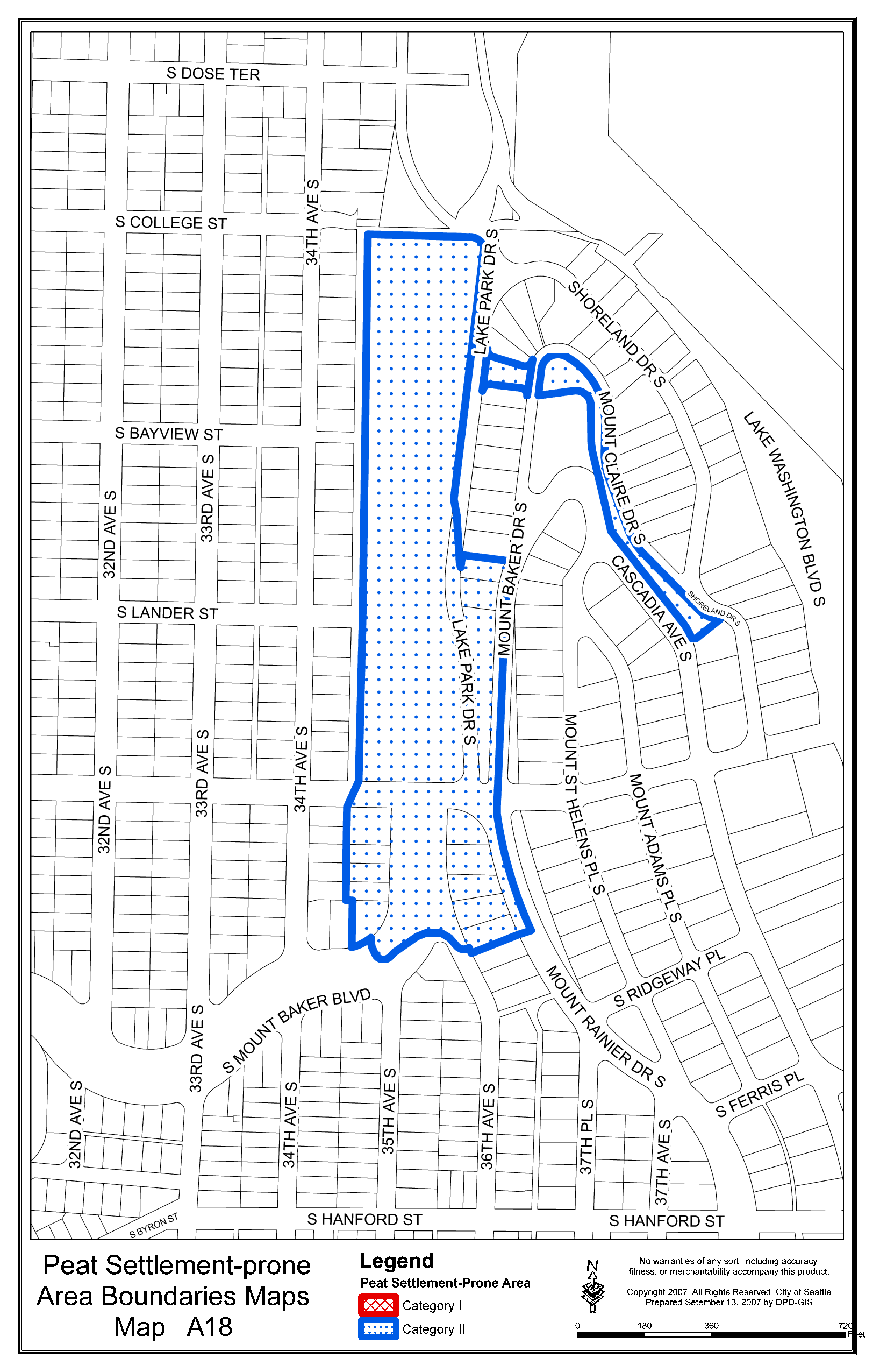
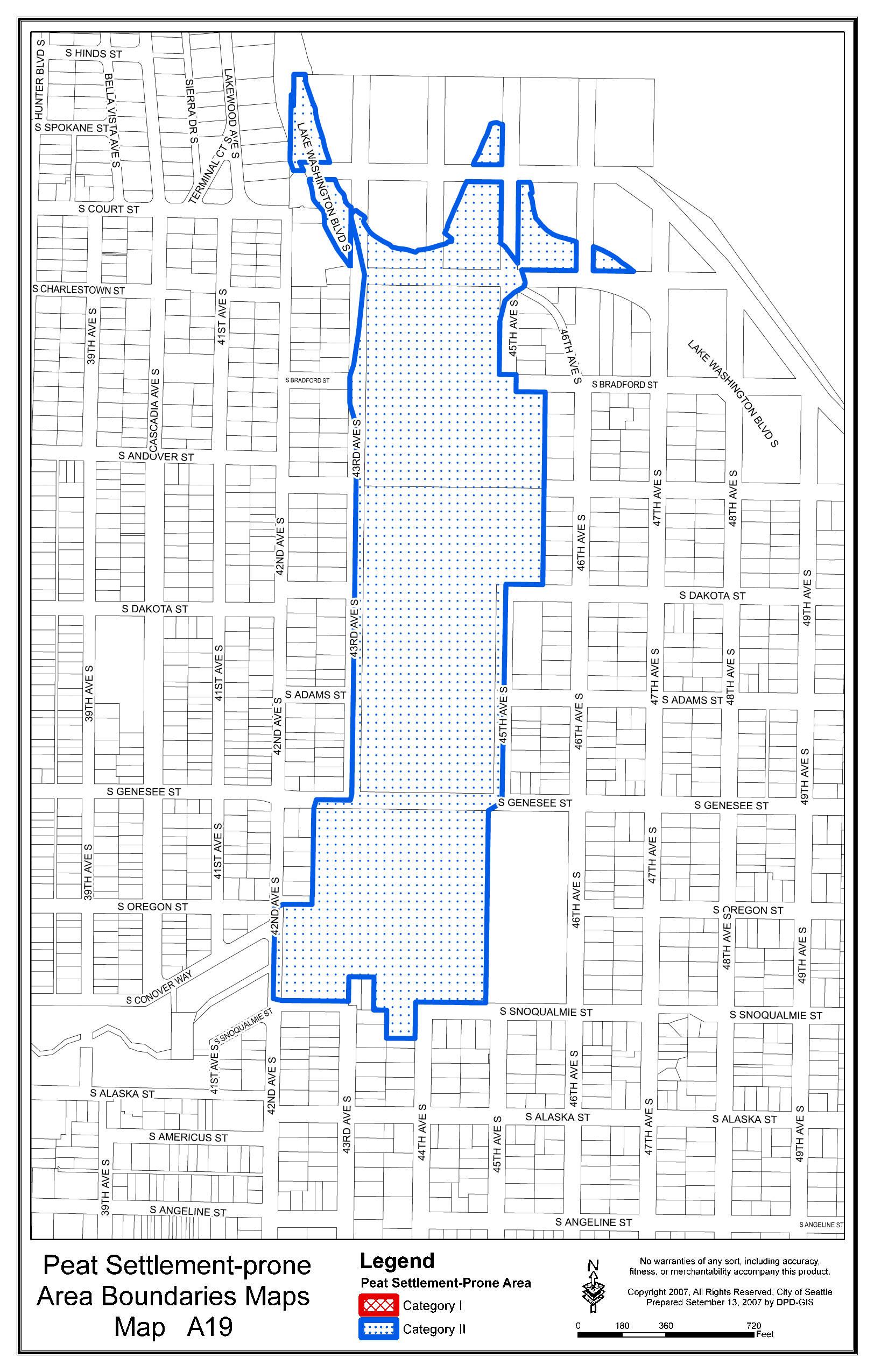
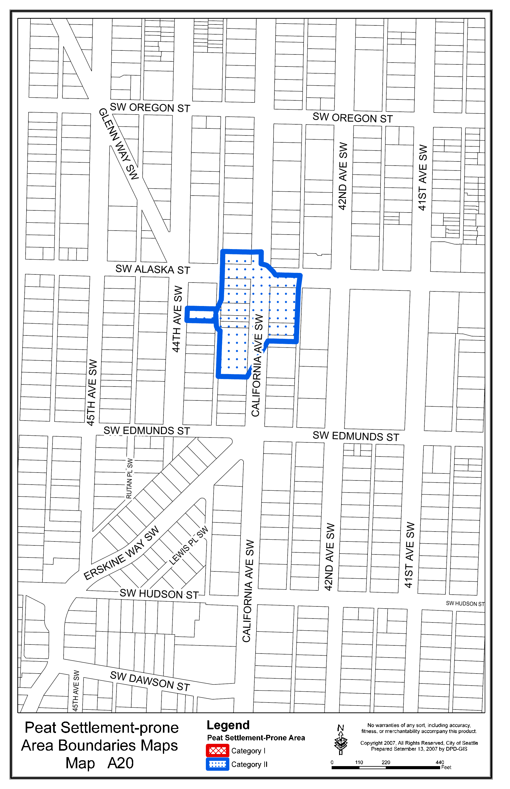
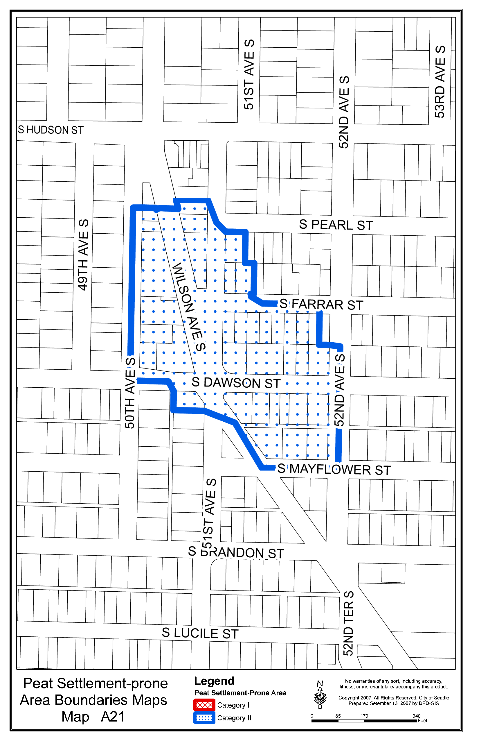
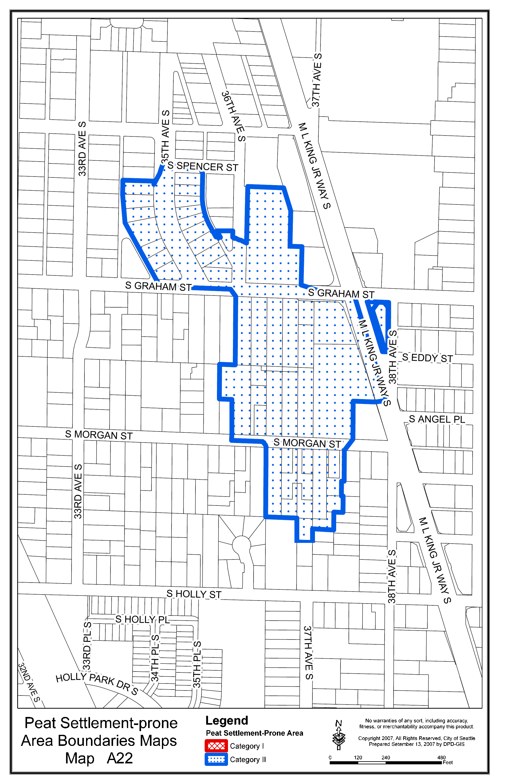
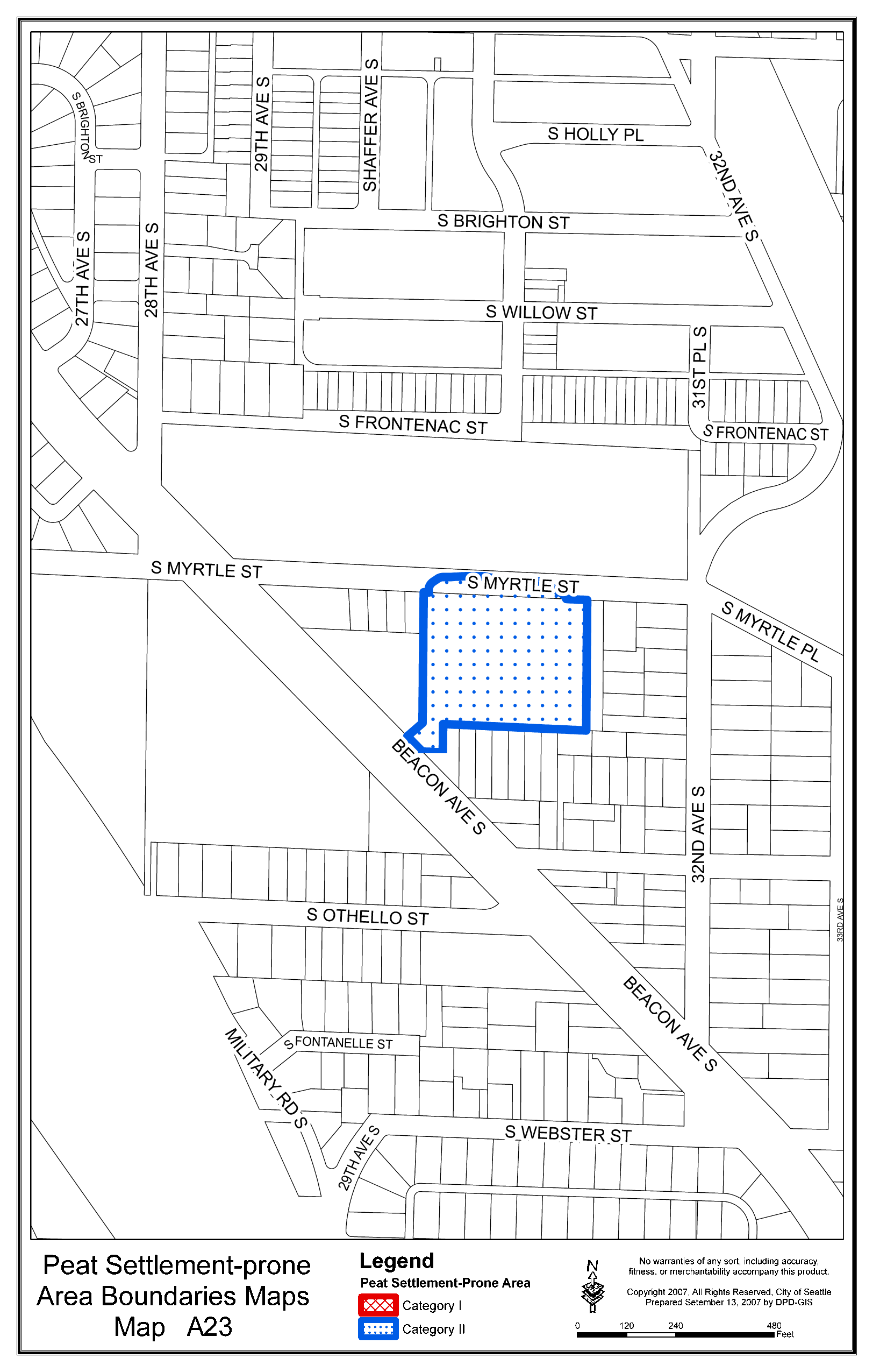
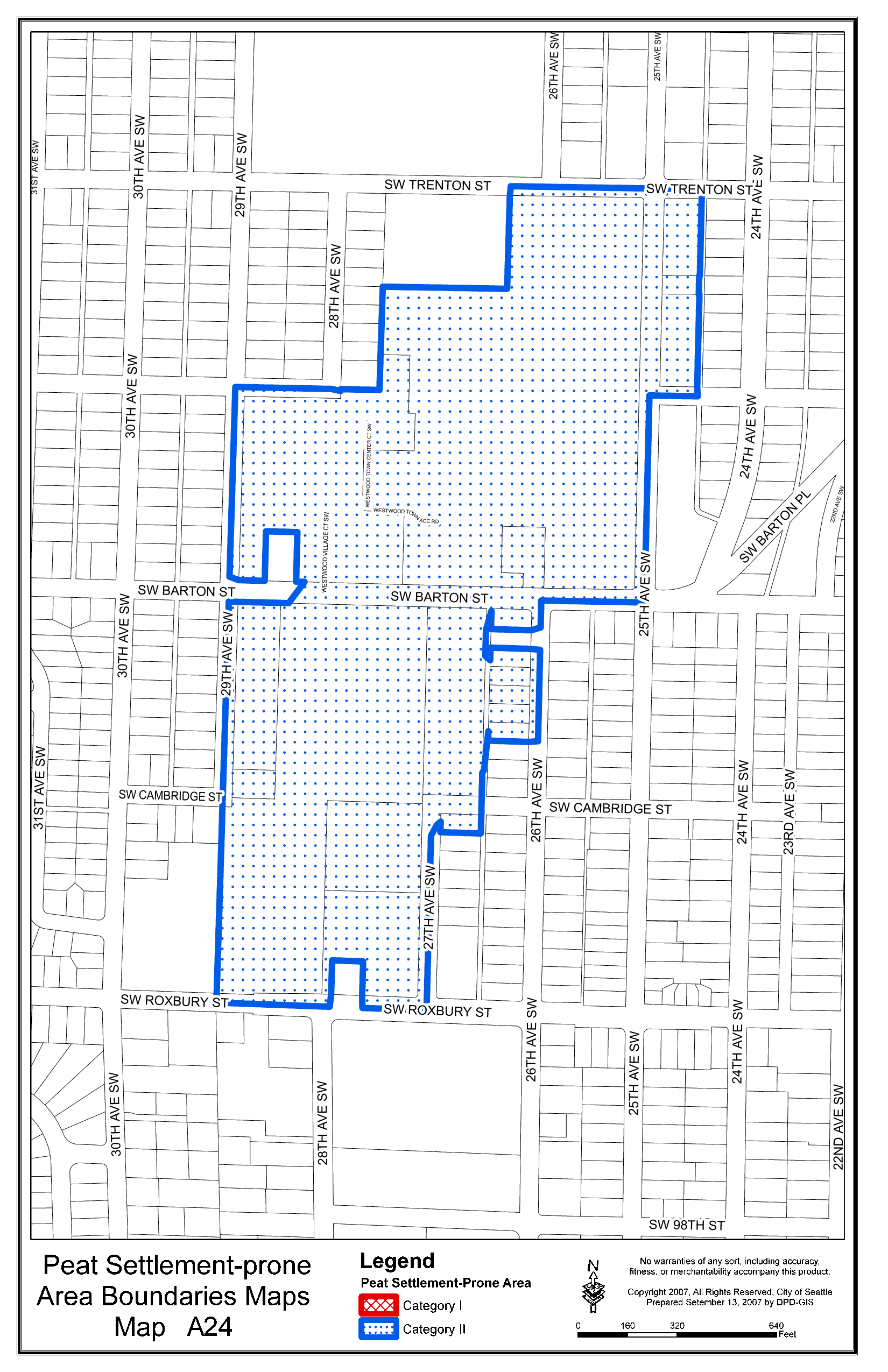
a. Peat settlement-prone areas, which consist of Category I and Category II peat settlement-prone areas, are delineated on Maps A1 through A26, Peat Settlement-prone Area Boundaries Maps, codified at the end of this chapter.
b. The Director may, at the request of the owner of a parcel larger than 50,000 square feet, provide a parcel-specific delineation of the peat settlement-prone area boundary on that parcel. Where a parcel-specific delineation conflicts with the Peat
Settlement-prone Area Boundaries Maps, the parcel-specific delineation shall apply. The parcel-specific delineation is based on the location of the relevant bog or bogs identified in City of Seattle Identified Bogs (Troost 2007) plus a buffer of 50
feet for Category I peat settlement-prone areas or a buffer of 25 feet for Category II peat settlement-prone areas.
a. Areas of the City subject to ground shaking from seismic hazards that are addressed by the Building Code (SMC Title 22). b. The Seattle Fault zone as delineated in Troost et al., 2005, The geologic map of Seattle, a progress report, U.S. Geological Survey, Open-file report 2005-1252 or as the Director determines is more accurately mapped by the U.S. Geological Survey, as set out in a Director's Rule. c. For tsunamis the waterbody of Lake Washington and for tsunamis and tsunami inundation, the water body and land area as shown in Walsh, et al., 2003, Tsunami hazard map of the Elliott Bay area, Seattle, Washington: Modeled tsunami inundation from a Seattle Fault earthquake, Washington State Department of Natural Resources and National Oceanic and Atmospheric Administration. Washington Division of Geology and Earth Resources Open File Report 2003-14, or as the Director determines are more accurately mapped by the National Oceanic and Atmospheric Administration, the U.S. Geological Survey or the Washington State Department of Natural Resources, as set out in a Director's Rule. d. The shoreline and upland areas surrounding Lake Washington are classified as an unknown risk from tsunamis under WAC 365-190-080 (4)(b)(iii). e. For seiches, the waterbodies of Elliot Bay, Lake Union and Lake Washington. f. The shoreline and upland areas surrounding the waterbodies in subsection (e) are classified as an unknown risk from seiches under WAC 365-190-080 (4)(b)(iii)
*** Section 7. Section 25.09.030 of the Seattle Municipal Code, which Section was last amended by Ordinance 122370, is amended as follows: 25.09.030 Location of environmentally critical areas and buffers.
A. Environmentally critical areas are defined in Section 25.09.020, and buffers are described in Sections 25.09.160, 25.09.180, and 25.09.200B. Environmentally critical areas are mapped whenever possible. Except for the maps adopted as designations
for geologically hazardous areas in subsections 25.09.020.A.5 B. The Director shall determine whether a parcel contains an environmentally critical area or buffer before other provisions of this chapter are applied. In determining whether a parcel contains an environmentally critical area or buffer, the Director may consider the environmentally critical areas maps, site surveys, topographic maps, technical environmental analysis, and any other information the Director determines necessary. In determining whether development is subject to regulation under Section 25.09.110, the Director may consider only whether the development will occur within an area delineated pursuant to subsection 25.09.020 A5. Section 8. Subsection A of Section 25.09.055 of the Seattle Municipal Code, which Section was last amended by Ordinance 122050, is amended as follows: 25.09.055 Small project waiver. A. The Director may approve new accessory structures or additions to existing structures in the environmentally critical areas and buffers listed in subsection A2, provided that no construction occurs over or in a water course, water body, or wetland, when the applicant demonstrates the proposal meets the following criteria: 1. The new accessory structure or addition to an existing structure is on a lot that has been in existence as a legal building site prior to October 31, 1992. 2. The development does not exceed one hundred and fifty (150) square feet in riparian management areas or in wetland buffers, three hundred (300) square feet in steep slope areas or buffers, or seven hundred fifty (750) square feet in landslide-prone (except steep slope), liquefaction-prone, flood-prone, and abandoned land fill areas, all calculated cumulatively from October 31, 1992. When the new accessory structure or addition to an existing structure is on a lot that is or has been held in common ownership with a contiguous lot and the lots are or have been used for a single principal use or for a principal use and accessory use, the limitation applies to the entire site. 3. It is not possible to build the accessory structure or addition to an existing structure for the intended purpose out of the environmentally critical area or buffer. 4. The location of the accessory structure or addition to an existing structure keeps impact on the environmentally critical area and buffer to a minimum. 5. In landslide-prone areas the Director may require a soils report prepared by a qualified geotechnical engineer or geologist licensed by the State of Washington demonstrates that it is safe to construct the new accessory structure or the addition to an existing structure. * * * Section 9. A new Section 25.09.110 of the Seattle Municipal Code, is adopted to read as follows: 25.09.110 Development standards for peat settlement-prone areas. A. The general development standards set out in Section 25.09.060 do not apply to peat settlement-prone areas. B. A geotechnical study detailing the location of the annual high static groundwater level is required for development in peat settlement-prone areas that involve excavation more than thirty (30) inches below the existing grade. C. No development shall occur within a peat settlement-prone area below the annual high static groundwater level except to the minimum extent the Director deems necessary to allow the following: 1. Structural components required under Title 22, Subtitle I and IA, the Building Code and Residential Code; 2. Utility lines, including but not limited to drainage and sanitary side sewers and stormwater conveyance facilities, but excluding groundwater collection systems; 3. Geotechnical testing; 4. Maintenance, repair, renovation, or structural alteration of an existing structure if that activity, even though it might involve construction activity below the annual high static groundwater level, does not increase the extent of the structure below the annual high static groundwater level; 5. Aquatic habitat restoration; 6. Infiltration facilities or other development designed primarily to encourage recharge or infiltration of water to the groundwater; 7. Replacement of contaminated soils with other soils or fills when the applicant demonstrates to the satisfaction of the Director that the removal will not increase the likelihood of settlement on off-site parcels; 8. Public utility facilities designed to provide drinking water, control flooding or protect against sanitary or combined sewer overflow when the applicant demonstrates to the satisfaction of the Director that the facilities have been designed to avoid or minimize to the maximum extent practicable impacts to the groundwater regime; or 9. Elevator pits necessary to meet accessibility standards required by City law. D. Groundwater collection systems are prohibited in peat settlement-prone area unless otherwise required by law. E. Development in a Category I peat settlement-prone area shall not increase the total impervious surface on the site unless the Director approves using an infiltration facility or soil amendments that offset the lost infiltration function. The Director may waive this requirement to the extent offsetting the lost infiltration function would adversely affect a landslide-prone area or steep slope area. F. For construction activity in a peat settlement-prone area, the Director may require additional construction practices, methods, and restrictions that limit temporary groundwater de-watering. G. In a peat settlement-prone area, land-disturbing activities with the potential to modify the groundwater regime are limited to the minimum reasonably necessary for development. Surface drainage systems or substantial earth modifications shall be professionally designed to prevent maintenance problems and adverse impacts to offsite parcels. H. In addition to requiring the information provided pursuant to Section 25.09.330 and to Director's Rules, the Director may require third-party review when the professional opinions of the applicant's representative and the Department's reviewers cannot be reconciled. Third-party review requires the applicant's geotechnical and/or additional technical studies to be reviewed by an independent third party, paid for by the applicant but hired by the Director. Third-party review shall be conducted by a qualified engineering consultant. I. The Director may waive compliance with some or all of the requirements of subsections B G for a project in a Category II peat settlement-prone area to the extent the applicant demonstrates to the satisfaction of the Director that the project has been designed to avoid adverse impacts to off-site parcels from peat settlement. Such impacts include but are not limited to any adverse, off-site effect resulting from temporary dewatering during construction, groundwater inflow due to normal operation and maintenance of underground structures, groundwater inflow due to potential future leaks that could occur in underground structures, and reduced impervious surface. Projects qualifying for a waiver under this subsection may include but are not limited to the following: 1. Projects involving concurrent removal of all peat contained in an entire peat settlement-prone area; 2. Concurrent development or redevelopment of the entire peat settlement-prone area that is designed to minimize modification of the groundwater table and avoid impacts of future settlement through design of new structures; or 3. Projects that are designed to minimize modification of the groundwater regime and that avoid potential adverse, off-site settlement impacts by retrofitting existing structures on off-site parcels within the entire peat settlement-prone area. J. Standards for height and floor area ratio may be modified on lots containing a peat settlement-prone environmentally critical area as provided in 23.47A.012 and 23.47A.013. K. Nothing in this section (including but not limited to subsection I) limits the authority of the Director pursuant to other applicable codes or regulations (including but not limited to Title 22, Subtitles I and IA, the Building Code and Residential Code) to require additional studies or impose additional conditions to address project-related risks arising in peat settlement-prone areas. Section 10. Section 25.09.520 of the Seattle Municipal Code, which Section was last amended by Ordinance 122050, is amended as follows: 25.09.520 Definitions. *** "Annual high static groundwater level" means the highest elevation where the soil is saturated with the main body of groundwater during any part of the year. *** "Contaminated soils" is defined in Section 21.36.012, Solid Waste Code. *** "Groundwater regime" means the amount, distribution, and seasonal variation of water below the surface of the land. *** "Infiltration facility" is defined in Section 22.801.100, Stormwater, Grading and Drainage Control Code. *** "Utility lines" means pipes, cables or other linear conveyance systems used to transport power, water, gas, oil, wastewater or similar items. *** Section 11. The provisions of this ordinance are declared to be separate and severable. The invalidity of any particular provision shall not affect the validity of any other provision. Section 12. This ordinance shall take effect and be in force thirty (30) days from and after its approval by the Mayor, but if not approved and returned by the Mayor within ten (10) days after presentation, it shall take effect as provided by Municipal Code Section 1.04.020. Passed by the City Council the ____ day of _________, 2008, and signed by me in open session in authentication of its passage this _____ day of __________, 2008. _________________________________ President __________of the City Council Approved by me this ____ day of _________, 2008. _________________________________ Gregory J. Nickels, Mayor Filed by me this ____ day of _________, 2008. ____________________________________ City Clerk Exhibit A: Peat Settlement-prone Areas Boundaries Maps A1 A26 Exhibit B: Best Available Science Report for Peat Settlement-prone Areas July 8, 2008 Version #3 (As Amended in Committee on 7.8.08) t Exhibit A: Peat Settlement-prone Areas Boundaries Maps A1 A26 EXHIBIT B: Best Available Science Report August 16, 2007 1 Best Available Science Report For Peat Settlement-prone Geological Hazard Areas The report was prepared by Brennon Staley, MUP in Urban Planning, and reviewed by Susan Chang, Ph.D. in Civil Engineering, P.E. Overview Peat is an accumulation of partially decayed organic plant material that typically forms in wetland where lack of oxygen and acidic conditions inhibit complete decay. Unconsolidated peat deposits are generally characterized by a fibrous structure exhibiting weak compressive strength and high void ratios (i.e., containing significant void space). Peat deposits are subject to settlement when loaded with additional weight or when groundwater levels are lowered. Lowering of the groundwater level reduces the buoyancy of overlying soils, thus increasing the pressure on the peat deposit and potentially resulting in compression. Settlement can occur where new fill or structures load soil or where groundwater levels are lowered due to sump pumps, temporary construction dewatering withdrawals, or other drainage projects. Because settlement can be induced by lowering of the groundwater table as well as by direct loading of the soil, settlement of peat deposits can occur a significant distance from the originating development activity because water withdrawals can influence the water table off-site. Seattle Context In the City of Seattle, peat deposits have typically formed in topographical basins created during the most recent glacial retreat and in the nearshore areas of lakes, the floodplains of the Duwamish River, depressions along modern streams, and marine estuaries. The lowering of Lake Washington by nine feet in 1916 also exposed significant areas of former lake bottom that contain peat deposits. As the City developed, these boggy areas were often filled to reclaim marshy areas considered to be a nuisance due to standing water and odors as well as to provide more developable land. Consequently, some of the many peat deposits have been buried and now support development throughout the City. Urban development in these areas has led to further alterations which have impacted the peat deposits and their settlement potential. Drainage projects were initiated in some areas of the City to drain wet areas and redirect stream flows. Installation of storm drains and sewer systems, sump pumps, and impervious surface have reduced the amount of groundwater recharge through diversion of stormwater and groundwater inflow. Regrading projects and public utilities may also have changed water flow directions and created new flow corridors where granular fill has created new pathways of increased permeability. Together, these modifications have led to significant cumulative impacts where altered hydrology has created new equilibrium states, as well as acute impacts where individual development projects adversely affected nearby properties. Mechanics of Peat Settlement The magnitude of settlement occurring in a particular location is based on a number of factors including: * Geotechnical characteristics of the peat * Thickness of the peat deposit * Existing pressure on the peat * Change in pressure on the peat * Historic loading of the peat These relationships can be expressed in the following equation: Expected Total Settlement = st = si + sc + ss where si = immediate settlement sc = primary consolidation ss = secondary compression. Immediate settlement is only of concern during fill or structure loading. Because these concerns are adequately addressed by existing building code standards, they are not a topic for this paper, which remains focused on potential off-site impacts. Primary consolidation is a time-dependent settlement process that occurs in saturated fine-grained soils that have low permeability. The settlement is due to water slowly being forced from the void spaces of the soil due to increases in load on the soil. For soils such as peat and other highly organic soils with high natural water content and high void ratios, primary consolidation settlements can be large. Primary consolidation is made up of a recompression component (settlement due to loading up to the maximum past pressure experienced by the peat) and a virgin compression component (settlement due to loading greater than the maximum past pressure experienced by the peat). Primary consolidation can be estimated with parameters from laboratory testing using the following equation (Holtz and Kovacs, 1981): sc = where sc = primary consolidation Cr = recompression index Cc = compression index H = thickness of the peat eo = initial void ratio (volume of voids divided by volume of solids) po' = initial effective stress on the peat pp' = maximum past pressure on the peat pf' = final effective stress on the peat Primary consolidation settlement can take several months to complete. Secondary compression is a continuation of the volume change that starts during primary consolidation, but it occurs at a much slower rate. It constitutes a major part of the total settlement of peats and other highly organic soils, and it may continue for an indefinite time period, creating a continuing hazard. Secondary compression can be estimated with parameters from laboratory testing and the following equation: ss = where ss = secondary compression C? = secondary compression index H = thickness of the peat ep = void ratio at end of primary consolidation t = time period being considered for design Once consolidation has occurred, peat deposits will never return to their original state, although minimal rebound is possible if weight is removed or the water level increases. Estimates of the expected settlement due to groundwater table drawdown derived from the preceding formulas are included in Tables 1 and 2. The settlement estimates were based upon the following with the understanding that peat settlement properties can be highly variable: (1) consolidation parameters from the WSDOT Geotechnical Design Manual of Cc??= Cc/(1+eo) = 0.4 and C?? =0.06 * Cc?? (2) initial water table at 2 feet below the ground surface drawn down to 7 feet below the ground surface Table 1: Estimated primary settlement (in inches) expected due to groundwater table drawdown from 2 feet below surface to 7 feet below surface. Depth to top of Vertical Thickness of Peat Deposit peat deposit (ft) 2 ft 3 ft 5 ft 10 ft thickness thickness thickness thickness 0 0 1/2 1 1/2 11 5 2 3 5 9 10 1 1/2 2 3 1/2 6 1/2 20 1 1 2 4 Table 2: Estimated total settlement (in inches) expected due to groundwater table drawdown from 2 feet below surface to 7 feet below surface. Depth to top of Vertical Thickness of Peat Deposit peat deposit (ft) 2 ft 3 ft 5 ft 10 ft thickness thickness thickness thickness 0 0 1/2 4 16 5 3 4 1/2 7 1/2 14 10 2 1/2 3 1/2 6 11 20 2 2 1/2 4 1/2 9 Effects of Settlement The impacts of settlement can be significant, particularly where differential settlement occurs due to a peat deposit having variable thickness, groundwater flow directions, slopes, differential loading, or previous compressions. Common damages from settlement include uneven or cracked foundations, cracks in the interior finishes, sticking windows and doors, broken underground utilities, and uneven sidewalks and roads. These problems may cause existing structures to become more prone to damage during earthquakes. Flooding may also occur both as pipes break and settlement lowers the elevation of yards and structures, creating ponding, or even lowering areas below the water table. Because settlement occurs gradually, the impacts of additional loading or groundwater withdrawals may appear gradually after an initial modification. Historic Settlement in Seattle Evidence of gradual settlement has been found in many localized areas of Seattle. Areas in Greenwood, the most studied area of peat-rich soils, have been experiencing documented settlement of roads and structures as far back as 1958 (Shannon & Wilson 2004). Union Bay, one of the deepest known peat deposits in Washington State, has also experienced significant recorded settlement (Montlake Landfill Work Group, 1999). In 2001, sections of the Greenwood neighborhood began to experience unexpected acute settlement. Developed on the location of historic wetlands, substantial subsurface peat deposits have been found under portions of Greenwood including part of the Greenwood business district and the residential area north and west of NW 85th Street and Greenwood Avenue North. This area, commonly referred to as the "Greenwood Bog," constitutes a topographical depression bordered by Phinney Ridge to the east and Crown Hill and Blue Ridge to the west. Lowered groundwater levels resulting from development along Greenwood Avenue North appear to be a cause of this settlement, although insufficient data exists to pinpoint an exact source (Shannon & Wilson, 2004). Data for assessing the effects of settlement in other parts of the City is not readily available. Peat Studies in Seattle A number of relevant studies have been conducted in Seattle that have added to the knowledge of peat and peat settlement occurring within the City including the Map of Organic-Rich Deposits developed by GeoMapNW (Troost, 2006) and the Shannon & Wilson Greenwood Subsurface Characterization Study (2004). The Map of Organic-Rich Deposits (GeoMapNW 2006) project compiled and analyzed boring logs submitted to the City of Seattle in conjunction with permit applications between 1914 and 2006. 33,270 reports were compiled and analyzed to identify subsurface deposits of peat greater than one foot in thickness. These results were then extrapolated based on historic geomorphology and hydrology to estimate the extent of peat deposits as well as other organic-rich geologic units, including wetland, lake, tideflat, and Vashon recessional lake deposits. Follow-up work completed in June 2007 refined the earlier map and identified discrete bogs. This 2007 map, City of Seattle Identified Bogs, dated June 19, 2007, relied on 34,909 data points. The map shows both discrete bogs and individual borings/data points that indicate a presence of peat in the subsurface. This analysis summarized each of the peat deposits based on four factors that indicate potential risk due to settlement: thickness of peat, depth to peat, depth to groundwater level, and location of groundwater level in relation to peat. This characterization provides a critical resource for determining where much of the City's peat settlement hazards exist. The map relies on available borehole data, geologic mapping, and geologic interpretation. Another important study of peat settlement within Seattle is the Greenwood Subsurface Characterization Study (Shannon & Wilson, 2004). This study was commissioned by Seattle Public Utilities in response to acute settlement occurring in the neighborhood to determine underlying geologic conditions. The study developed a map that delineates the former peat bog area and identifies the depth and thickness of the peat throughout the area. Shannon & Wilson also tested the peat to determine the potential to re-introduce water into the substrata and placed monitoring devices in several locations for a long-term assessment of groundwater flows and levels in the area. The study concluded that settlement in the neighborhood was "likely the result of groundwater removal" occurring due to multiple factors including construction of impervious surface, diversion of stormwater, installation of the 1970s storm drain system, natural groundwater fluctuations, climate change, construction dewatering and permanent drainage systems in subsurface structures. Shannon & Wilson warned that the "continued groundwater removal and the removal of groundwater from other locations within the study area could contribute to additional or new settlement, and should be avoided where settlement could impact structures, utilities, roadways and other improvements." (Shannon & Wilson, 2004) Implications for Regulation Development in areas containing peat deposits can result in settlement where new structures or fill compress underlying peat soils or where modification of the groundwater table increases the effective pressure on underlying peat soils. To avoid negative impacts from development, it is necessary to ensure both that new structures are designed to prevent or accommodate settlement and that they do not cause settlement off-site through modification of the groundwater table. Regulations should specifically seek to minimize modification of the existing groundwater regime because any modification of existing groundwater regime that removes or redirects groundwater even for a short period may lead to local groundwater depressions resulting in settlement. Alternatively, modifications of the groundwater table that increase groundwater levels, although they would not lead to settlement, may also be undesirable as they can not significantly reverse previous settlement activity and may lead to flooding. Determination of areas that should be included in potential regulations should consider all the variables impacting settlement potential discussed earlier, including geotechnical characteristics of the peat, peat thickness, existing pressure on the peat, potential changes in pressure on the peat (including groundwater levels), and historic loading of the peat. Within regulated areas, protections should be applied even where geotechnical explorations fail to reveal peat deposits on the site of a proposed development because peat deposits may be present on nearby parcels. References Berry, P.L., and Vickers, B., 1975, Consolidation of Fibrous Peat, Journal of the Geotechnical Engineering Division, ASCE vol. 101, GT 8, August p. 741-753. City of Seattle Peat Settlement Technical Review Committee, 2007, Consensus Statements. Fox, P.J., et al., 1992, C sub alpha/C sub c Concept Applied to Compression of Peat, Journal of the Geotechnical Engineering Division, ASCE vol. 118, GT 8, August, p. 1256-1263. Holtz, R. D. and Kovacs, W. D., 1981, An Introduction to Geotechnical Engineering, Prentice-Hall. Landva, A.O., and Pheeney, P.E., 1980, Peat Fabric and Structure, Canadian Geotechnical Journal, vol. 17, no. 3, August, p. 416-435. Montlake Landfill Work Group, 1999, Montlake Landfill Information Summary, January. Rigg, George B., 1958, Peat Resources of Washington, State of Washington, Division of Mines and Geology Bulletin 44, State Printing Plant, Olympia, WA. Shannon & Wilson, 2004, Greenwood Subsurface Characterization Study: Seattle, Washington, April 21. Troost, Kathy, 2006, Map of Organic-Rich Deposits in Seattle, GeoMapNW, University of Washington, June 14. Troost, Kathy, 2007, City of Seattle Identified Bogs, GeoMapNW, University of Washington, June 29.
Washington State Department of Transportation, 2006, Publication M 46-03: Geotechnical Design Manual, Environmental and Engineering Programs, State Materials Laboratory, Chapter 5, p. 21-22, December,
Technical Review Committee
Steve Erickson; Frosty Hollow Ecological Restoration Steve Greene; HWA Geosciences Thomas Kinney; HWA Geosciences Kathy Troost; University of Washington, GeoMapNW Mark Varljen; SCS Engineers
|
|
Attachments |
|---|
![[TOP]](/netaicon/toppg.gif)