![[HOME]](/netaicon/homeicon.gif)
![[SEARCH]](/netaicon/srchpage.gif)

![[CURR_LIST]](/netaicon/curlist.gif)


![[BOTTOM]](/netaicon/bottom.gif)
![[HELP]](/netaicon/help.gif)
Seattle City Council Bills and Ordinances
Information modified on October 2, 2023; retrieved on May 9, 2026 10:16 AM
Ordinance 121212
Introduced as Council Bill 114611
Title | |
|---|---|
| AN ORDINANCE relating to the construction of an electric power transmission line project through the Cedar River Watershed; authorizing the Mayor to execute an agreement with the Bonneville Power Administration establishing the terms and conditions for expansion of an existing electric power transmission right of way in the Watershed; authorizing the granting of an easement for said expanded right of way pursuant to said agreement across portions of Sections 2, 11, 14, and 23, Township 22 North, Range 7 East, W.M., and Section 35, Township 23 North, Range 7 East, W.M; authorizing the cutting and removal of trees and other vegetation from the right of way pursuant to said agreement; declaring the logs resulting from such cutting to be surplus to the City's needs and authorizing the sale of such logs pursuant to said agreement; directing deposit of the proceeds therefrom to the Water Fund for dedicated purposes; authorizing the acceptance of deeds to certain properties located in portions of Section 26, Township 23 North, Range 7 East, W.M., Section 25, Township 22 North Range 7 East, and Section 5, Township 21 North, Range 11 East, W.M. and the receipt and deposit to the Water Fund for dedicated purposes of certain monies, together representing mitigation for the project's impacts and compensation for the rights granted through said agreement. | |
Description and Background | |
|---|---|
| Current Status: | Passed |
| Fiscal Note: | Fiscal Note to Council Bill No. 114611 |
| Index Terms: | WATERSHEDS, INTERLOCAL-AGREEMENTS, BONNEVILLE-POWER-ADMINISTRATION, POWER-TRANSMISSION-FACILITIES, TRANSMISSION-LINES |
| Notes: | Note: Scanned signed copy document is very large: 227 MB |
| References: | Exhibit A to the Agreement (Attachment A) is filed as Clerk File 306206. Exhibit B to the Agreement (Attachment A) is filed as Clerk File 306205. |
Legislative History | |
|---|---|
| Sponsor: | PAGELER |
| Date Introduced: | June 16, 2003 |
| Committee Referral: | Water and Health |
| City Council Action Date: | July 7, 2003 |
| City Council Action: | Passed |
| City Council Vote: | 9-0 |
| Date Delivered to Mayor: | July 8, 2003 |
|
Date Signed by Mayor: (About the signature date) | July 14, 2003 |
| Date Filed with Clerk: | July 15, 2003 |
| Signed Copy: | PDF scan of Ordinance No. 121212 |
Text | |
|---|---|
|
AN ORDINANCE relating to the construction of an electric power transmission line project through the Cedar River Watershed; authorizing the Mayor to execute an agreement with the Bonneville Power Administration establishing the terms and conditions for expansion of an existing electric power transmission right of way in the Watershed; authorizing the granting of an easement for said expanded right of way pursuant to said agreement across portions of Sections 2, 11, 14, and 23, Township 22 North, Range 7 East, W.M., and Section 35, Township 23 North, Range 7 East, W.M; authorizing the cutting and removal of trees and other vegetation from the right of way pursuant to said agreement; declaring the logs resulting from such cutting to be surplus to the City's needs and authorizing the sale of such logs pursuant to said agreement; directing deposit of the proceeds therefrom to the Water Fund for dedicated purposes; authorizing the acceptance of deeds to certain properties located in portions of Section 26, Township 23 North, Range 7 East, W.M., Section 25, Township 22 North Range 7 East, and Section 5, Township 21 North, Range 11 East, W.M. and the receipt and deposit to the Water Fund for dedicated purposes of certain monies, together representing mitigation for the project's impacts and compensation for the rights granted through said agreement. WHEREAS, the City, through its Seattle Public Utilities ("SPU"), owns and manages the more than 90,000-acre Cedar River Watershed ("Watershed"), which is a source of unfiltered drinking water for Seattle and surrounding communities and home to many specifies of fish and wildlife, some of which are listed as endangered or threatened under the federal Endangered Species Act; and WHEREAS, the United States of America, through its Department of Energy, Bonneville Power Administration ("BPA"), presently owns, operates, maintains and manages an electric power transmission line on a 150-foot-wide right of way through the Watershed over and across portions of Sections 2, 11, 14, and 23, Township 22 North, Range 7 East, W.M., and Section 35, Township 23 North, Range 7 East, W.M. on two easements granted and recorded in 1967; and WHEREAS, to improve its system's reliability and capacity in the region, BPA plans to construct, operate, maintain and manage additional electric power transmission facilities that require an additional 150-foot strip of land abutting the existing right of way and has named this plan the Schultz-Echo Lake Transmission Line Project (the "Project"); and WHEREAS, pursuant to the National Environmental Policy Act (NEPA) BPA has completed its Final Environmental Impact Statement (FEIS) addressing the acquisition, construction and management of the Project; and WHEREAS, the City has formally adopted the NEPA FEIS in accordance with SMC 25.05.610 and SMC 25.05.630; and WHEREAS, BPA has commenced formal condemnation proceedings to acquire an easement for the Project; and WHEREAS, through its NEPA process and negotiations with representatives of the City, BPA has agreed to certain terms regarding protection of the surface waters and other elements of the environment in the Watershed in the construction, operation, maintenance and management of the Project, mitigation for the Project's unavoidable adverse impacts on the Watershed, and compensation to the City for the right to cross the Watershed with its Project; and WHEREAS, representatives of the City and BPA have prepared the Schultz-Echo Lake Transmission Line Project Settlement Agreement setting forth such terms in detail and including various documents required to implement the Project pursuant to the agreed terms; NOW, THEREFORE, BE IT ORDAINED BY THE CITY OF SEATTLE AS FOLLOWS: Section 1. The Mayor is hereby authorized to execute, for and on behalf of the City, the Schultz-Echo Lake Transmission Line Project Settlement Agreement ("Agreement"), substantially in the form attached hereto. Section 2. The Director of Seattle Public Utilities is hereby authorized to execute the Grant of Easement over and across portions of Sections 2, 11, 14, and 23, Township 22 North, Range 7 East, W.M., and Section 35, Township 23 North, Range 7 East, W.M., substantially in the form attached to the Agreement as Exhibit I. Section 3. The Director of Seattle Public Utilities is hereby authorized to allow the cutting and removal of trees for the purpose of clearing the expanded electric power transmission line right of way over and across portions of Sections 2, 11, 14, and 23, Township 22 North, Range 7 East, W.M., and Section 35, Township 23 North, Range 7 East, W.M., under the terms and conditions described in the Agreement. The City Council finds and declares that such clearing is an allowable non-commercial purpose or reason as defined in Section 2 of Ordinance 121040 and that, following a public hearing, the logs resulting from such clearing are hereby declared to be surplus to the City's needs. Section 4. The Director of Seattle Public Utilities is hereby authorized to sell, pursuant to applicable City contracting or surplus property sale procedures, and subject to the right of first refusal granted to the Mountain Tree Farm Company by the 1962 Cedar River Watershed Cooperative Agreement, any logs resulting from the clearing of the right of way, as provided is Section 3 of this ordinance. All proceeds from such sale of logs shall be deposited in the Water Fund and further dedicated exclusively for the purposes described in Sections II.3 and III.2. of the Agreement, and, for this sale only, such purposes shall supercede those set forth in Section 3 of Ordinance 121040. Section 5. The Director of Seattle Public Utilities is hereby authorized to accept deeds to certain properties located in portions of Section 26, Township 23 North, Range 7 East, W.M., Section 25, Township 22 North Range 7 East, and Section 5, Township 21 North, Range 11 East, W.M., all as provided and further described in Section III.1. of the Agreement, and to execute such other agreements, instruments and documents as may be necessary to effectuate the transfer of said properties. Section 6. The Director of Seattle Public Utilities is hereby authorized to receive and deposit in a separate account in the Water Fund monetary compensation in the amount of $6,000,000 as it becomes due and payable by BPA under the terms of Section III.2. of the Agreement. All monies in said separate account shall be further dedicated for the exclusive purposes of enhancing and accelerating existing programs for road improvement and abandonment, forest restoration, and aquatic restoration in the Watershed, and for security improvements and water quality monitoring in the Watershed, all as further described in Section III.2. of the Agreement, and these funds are to supplement, not supplant, the City's funding commitment in the 2003-2004 HCP budget and watershed management plan. Seattle Public Utilities (SPU), should involve community ratepayer representatives, as well as the appropriate HCP Oversight Committee and other stakeholders, in the selection of the mitigation projects and report to the Council on proposed mitigation projects and how they enhance and accelerate SPU's HCP commitments. Section 7. Any act taken pursuant to the authority and prior to the effective date of this ordinance is hereby ratified and confirmed. Section 8. This ordinance shall take effect and be in force thirty (30) days from and after its approval by the Mayor, but if not approved and returned by the Mayor within ten (10) days after presentation, it shall take effect as provided by Municipal Code Section 1.04.020. Passed by the City Council the ____ day of _________, 2003, and signed by me in open session in authentication of its passage this _____ day of __________, 2003. _________________________________ President __________of the City Council Approved by me this ____ day of _________, 2003. _________________________________ Gregory J. Nickels, Mayor Filed by me this ____ day of _________, 2003. ____________________________________ City Clerk Attachment A: Schultz-Echo Lake Transmission Line Project Settlement Agreement Exhibit I to Attachment A: Grant of Easement 6/9//2003 version #5 ta ATTACHMENT A: Schultz-Echo Lake Transmission Line Project Settlement SCHULTZ-ECHO LAKE TRANSMISSION LINE PROJECT SETTLEMENT AGREEMENT DATE: Effective ___________, 2003 This Settlement Agreement (Agreement) is made by and between the CITY OF SEATTLE (the City), a Washington municipal corporation, and THE BONNEVILLE POWER ADMINISTRATION (BPA). It establishes the understanding between the City and BPA (the Parties) regarding the terms under which BPA will be granted an easement across the Cedar River Municipal Watershed to construct, operate and maintain its Schultz-Echo Lake Transmission Line Project, formerly known as the Kangley-Echo Lake Transmission Line Project, and operate and maintain its existing Raver-Echo Lake transmission line through the Watershed. RECITALS A. The City is a municipal corporation in the state of Washington. The City owns the approximately 90,000 acre Cedar River Watershed (the Watershed), which is a source for unfiltered drinking water to over 1.3 million people in the Puget Sound region. B. BPA is a power-marketing agency within the United States Department of Energy. BPA is required to ensure that its transmission system can reliably serve customer needs under all operating conditions, including times of peak use. C. BPA currently owns, operates and maintains an existing transmission line that runs five miles on a 150-foot wide right of way through the Watershed, the 500-kV line between Raver and Echo Lake substations (the Raver-Echo Lake line). The Raver-Echo Lake line was originally constructed in 1968. BPA now seeks an easement for a transmission line right of way and associated access and service roads for an additional new single-circuit 500-kilovolt (kV) transmission line parallel and immediately adjacent to the Raver-Echo Lake 500-kV line through the Watershed. This proposed new line will extend a total of approximately 9 miles from a tap point on BPA's Schultz-Raver No. 2 500-kV line near Kangley, Washington, to BPA's Echo Lake Substation near North Bend, Washington. It will be known upon completion as the Schultz-Echo Lake transmission line. Because a portion of this new line will run through the Watershed, BPA requires an additional adjacent 150-foot wide right of way for five miles within the Watershed or about 90 acres. D. Pursuant to the National Environmental Policy Act (NEPA), BPA has completed its Final Environmental Impact Statement for the SchultzEcho Lake Transmission Line Project (formerly known as the KangleyEcho Lake Transmission Line Project) addressing the acquisition, construction and management of the Schultz-Echo Lake Transmission Line Project. E. BPA has prepared detailed plans for the construction of the Schultz-Echo Lake Transmission Line Project, including a Technical Specification Package, a Stormwater Pollution Prevention Plan (SWPPP), a Mitigation Action Plan (MAP), an Access Road Summary, a Clearing Plan and a Maintenance Agreement for BPA Facilities in the Cedar River Municipal Watershed. (Exhibits A through F respectively.) F. In 2000, the City, the U.S. Fish and Wildlife Service (USFWS), and NOAA Fisheries (formerly National Marine Fisheries Service ), through considerable public input, developed and agreed to the implementation of the Cedar River Watershed Habitat Conservation Plan (HCP) for protection of fish and wildlife, including threatened and endangered species. The HCP covers the City's activities within the Watershed and provides required Endangered Species Act (ESA) authorization for certain covered activities. NOAA Fisheries and the USFWS have determined that the new Schultz-Echo Lake Transmission Line Project will not adversely affect listed fish or jeopardize listed terrestrial species or adversely affect their designated critical habitat. The USFWS Biological Opinion and NOAA Fisheries Section 7 Concurrence Letter related to the Schultz-Echo Lake Transmission Line Project are attached hereto as Exhibits G and H, respectively. G. Pursuant to the provisions of this Agreement, BPA will control, manage and minimize the effects of the new and existing transmission lines on fish, wildlife, and water quality, and will provide compensatory mitigation for unavoidable impacts. BPA agrees and covenants that it is prohibited from constructing any additional transmission lines or clearing additional rights of way outside of the existing Raver-Echo Lake Transmission Line right of way and the new Schultz-Echo Lake Transmission Line right of way through the Watershed and will not seek to condemn at any time in the future any additional property in the Watershed. As a result, this Agreement will provide a significant net environmental benefit to the Watershed, even with the construction, operation, and maintenance of the Schultz-Echo Lake Transmission Line. The Schultz-Echo Lake Transmission Project will also provide electrical benefits to the City and the region. H. BPA asserts that it has the authority to condemn property that is reasonably necessary for the construction and operation of its transmission lines, including the Schultz-Echo Lake Transmission Line. However, through this Agreement the Parties intend to avoid condemnation. The Parties further agree that the total compensation and other consideration flowing to the City from BPA, pursuant to this Agreement, meets or exceeds the fair market value of the property that BPA will use for the portion of the Schultz-Echo Lake Transmission Line Project in the Watershed. AGREEMENT In consideration of their mutual promises and commitments, the Parties hereby mutually agree as follows: I. DEFINITIONS For purposes of this Agreement, "the Project" consists of all BPAowned facilities within the Watershed related to the Schultz-Echo Lake Transmission Line Project, including towers, conductors, communication facilities, service roads, and associated right-of-way and the maintenance thereof. Also included in "the Project" are the mitigation and compensation actions provided for under Section III of the Agreement and management activities under Section IV. For the purposes of this Agreement the phrase "life of the Project" means the period of time, beginning with the commencement of construction, that the Project continues to be constructed and utilized by BPA (or its successor) for power transmission purposes. For the purposes of this Agreement "Service Roads" and "Access Roads" mean those roads that are designated as such in Exhibit I-2 attached hereto. II. TRANSMISSION RIGHT OF WAY 1. Conveyance of Easement for Right of Way and Associated Roads In exchange for BPA's commitments as set forth in this Agreement and its Exhibits, which are hereby incorporated herein by this reference, the City agrees to grant and convey to BPA a perpetual easement for a right of way for both the new Schultz-Echo Lake transmission line, and the existing Raver-Echo Lake transmission line, all as more fully described in Exhibit I. (This easement provides BPA an additional 150-foot-wide transmission line right of way through the Watershed along the east side of and immediately adjacent to the existing right of way for the Raver-Echo Lake transmission line for a total width of 300 feet. The one exception to this 150 foot wide right of way expansion is on either side of the Cedar River, where BPA has agreed to use double circuit towers and use only the existing 150-foot right of way.) Said easement shall also provide for construction, maintenance and use by BPA of certain Access Roads and Service Roads within the Watershed associated with both the new Schultz-Echo Lake Transmission line and the existing Raver-Echo Lake transmission line, all as more fully described in Exhibit I-2. Said easement shall be subject to the terms, reservations and conditions specified in Exhibit I, as well as the terms and conditions of this Agreement and its other exhibits. 2. Novation of Existing Easement The Parties intend to integrate the management and maintenance of the existing Raver-Echo Lake Transmission Line with the new Schulz Echo Lake Line, so that the two transmission lines and their associated Service Roads shall be managed and maintained under a single set of maintenance and management plans. Thus, upon execution of this Agreement and the referenced new easement, the Parties' rights and obligations under the existing easements recorded on June 14, 1967 under King County Recording No. 6189299 and on September 19, 1967, under King County Recording No. 6236299, shall terminate, and shall be superseded by the rights and obligations described in this Agreement, and Exhibit I. 3. Timber Clearing BPA shall have the right to clear vegetation/trees consistent with the Technical Specification Package and the Clearing Plan attached hereto as Exhibits A and E, respectively, to allow for construction and the safe and reliable operation of the new Schultz-Echo Lake Transmission line. BPA shall pay all costs associated with carrying out the clearing activities specified in the Clearing Plan, including but not limited to transporting timber designated in the Clearing Plan for removal to sites specified in the Clearing Plan. The City shall be entitled to all revenues (i.e. gross revenues) that may be derived from the sale of any timber removed from the Watershed, provided that the City shall use these revenues to fund Watershed enhancement projects through the dedicated account and procedures established in Section III(2) of this Agreement. 4. Public Access Nothing in this Agreement creates a right of public access. The City retains the authority to regulate access in a manner that protects its public drinking-water supply, minimizes adverse impacts to fish and wildlife and their habitat, and otherwise maintains the natural resource values for which the Watershed is managed. Nothing in this Agreement limits the authority or ability of the City to manage the Watershed for public safety and fish and wildlife habitat conservation, or to preserve and protect cultural, historic, and religious sites. BPA agrees that it will observe the City's Watershed Access Water Quality and Control Regulations (Exhibit I-3) during the life of the Project. BPA may take reasonable additional measures to protect BPA-owned facilities within the Watershed. 5. Right of Way Use, Abandonment, Limitation on Expansion and Upgrade, and Prohibition of Future Condemnation The City shall have rights of access to the BPA right of way and Service Roads as described in Exhibit I for all uses not inconsistent with the BPA's easement rights. If BPA abandons, or ceases to use, the transmission lines, the easement and right of way granted pursuant to this Agreement shall revert to the City. BPA covenants and agrees that it will not seek to expand the size of any existing transmission line right of way and/or roads in the Watershed (beyond the expansion provided for in this Agreement) and that it will not propose or construct any additional right of way or seek to acquire any additional easement or property interest through or within the Watershed. However, BPA will be allowed to seek upgrades to existing lines and the installation of new equipment (which may include replacing the existing Raver-Echo Lake and/or the new Schultz-Echo Lake line with single circuit towers or double circuit towers and fiber wires attached to transmission towers) so long as such upgrades or such installations do not have significant environmental or water quality impacts. For the purposes of this provision, the term "significant environmental impact" shall be construed in accordance with NEPA and the Washington State Environmental Policy Act (SEPA) and their implementing regulations. Any upgrades or replacement work shall be subject to the terms and conditions of this Agreement to the extent applicable. BPA represents that there are currently no plans to upgrade the lines and BPA's studies have indicated no need for another transmission or fiber line through the Watershed beyond those described in this Agreement. Any proposed upgrades or installation of new equipment shall be subject to the federal NEPA process and the City's prior review and approval. The City's approval of proposed upgrades and installations shall not be unreasonably withheld but may be withheld if the proposed upgrade or installation is likely to have any significant environmental or water quality impacts. BPA may also upgrade roads for purposes of regulatory compliance, subject to the review and approval by the City, which approval shall not be unreasonably withheld. BPA further covenants and agrees that it will not now, or in the future, seek to condemn, nor support other party's condemnation, of any additional properties, easements, or rights of way within the Watershed. III. MITIGATION/COMPENSATION The Parties agree that the fulfillment of the promises and commitments set forth in this Agreement constitute full and adequate mitigation for all potential Project impacts in the Watershed and that the City is receiving adequate compensation for the new rights granted to BPA for the Project. 1. Transfer of Certain Properties to the City of Seattle In consideration of the rights granted to BPA under this Agreement and to help offset unavoidable impacts of the Project, BPA shall arrange for the transfer to the City of certain property in King County, Washington, adjacent to the Watershed as follows: a) Portions of the South half of Section 26, Township 23 North, Range 7 East, W.M. (the "Trillium Property"), as more fully described in Exhibit J, and consisting of approximately 110 acres. Approximately 60 acres of the Trillium Property are covered with second or third growth coniferous forest trees. The remainder of the Property has 10year-old trees, and the Property includes approximately 4.6 acres of wetlands. The Trillium Property will be conveyed by BPA to the City via a quitclaim deed with title insurance purchased at BPA expense. Upon conveyance of the Trillium Property to the City by BPA, BPA shall reserve a conservation easement on the on the Property in substantially the form attached hereto as Exhibit K. BPA shall also reserve a transmission line easement for the purpose of providing a 300 wide line right of way for BPA's transmission lines where they cross the SE 1/4 of Section 26, which reserved transmission line easement shall, insofar as applicable, be subject to the terms and conditions as the easement set forth in Exhibit I of this Agreement. BPA will convey the Trillium Property to the City not later than 90 days after the effective date of this Agreement. b) That portion of Section 25, Township 22 north, Range 7 West, W.M. north of the northern boundary of the existing BPA right of way through said Section (the "Selleck Property"), consisting of approximately 363 acres, 30 acres of which contain mature trees and the remaining acres containing trees that are approximately 10 years old. This property also has a creek and approximately 80 acres of wetlands. BPA shall retain a conservation easement on this property substantially similar to the conservation easement attached hereto as Exhibit K. BPA will arrange for the conveyance of the Selleck Property to the City to occur not later than one year after the effective date of this Agreement. BPA shall make best efforts to arrange for the transfer of the Selleck Property to the City under a statutory warranty deed. BPA shall transfer the property with title insurance purchased at BPA's expense. c) That portion of Section 5, Township 21 North, Range 11 East, W.M., bounded on the west by the City's ownership and on the north, east and south by the Cedar River Watershed's hydrographic boundary (the "Yakima Pass Property"), consisting of approximately 100 acres, almost all of which is covered with trees that are approximately 30 years old. A three-acre lake (Twilight Lake) is located within the Property. In order to pursue this acquisition, BPA will make its best efforts to obtain an agreement with the US Forest Service enabling BPA to convey the Yakima Pass Property to the City not later than three years after the effective date of this Agreement. Because BPA is not assured this property can be acquired, it will place $150,000 (the approximate value of the property) in an interest bearing escrow account. If a period of three years has passed since the execution of this Agreement without conveyance of the Yakima Pass property to the City, then the City may, at its discretion, extend the conveyance deadline for a period of up to one year. If BPA is not able to arrange such transfer under a statutory warranty deed, BPA shall transfer the property with title insurance purchased at BPA's expense. If, despite its best efforts, BPA is unable to acquire the Yakima Pass Property, then the escrowed funds shall be provided to the City for acquisition of other suitable property(ies) at the City's sole discretion. The City will manage the referenced properties under its present and future watershed management policies. 2. Monetary Compensation for Watershed Enhancement In partial consideration for the right to construct and maintain the new Shultz-Echo Lake Transmission Line through the Watershed, BPA shall, in addition to the other compensation and reimbursement provided for under this Agreement, pay the City the sum of $6,000,000 (Six Million Dollars). This payment shall be made in two installments of $3,000,000, the first to be made on or before October 30, 2003 or the commencement of construction, whichever is later, and the second to be made on or before October 30, 2004 which second payment may be delayed only in the event and to the extent that the City unreasonably causes delay in completion of construction. Such payments shall be used by the City to provide increased funding for the following programs and projects: * Enhancement and acceleration of the City's Road Improvement and Abandonment within the Watershed (including the removal of existing roads in the "Foothills" property in the South half of Section 23, Township 22 North, Range 7 East W.M..) to compensate and offset the effects of the additional road length added to the Watershed as a result of the Project; * Expansion and acceleration of the City's Upland Forest Restoration Program in the Watershed to help compensate for the loss of older second-growth forest habitat within the Watershed and the loss of future forest growth potential within the right of way area; * Enhancement and acceleration of the City's Watershed Riparian and Aquatic Restoration Program, to help compensate for the impacts to the riparian, stream and wetland habitat areas within the Watershed; * The purchase and installation of Watershed Security improvements to help restrict Watershed access. The City shall submit its plans for such improvements to BPA for review and comment prior to beginning such work. The City shall direct the six million dollars provided for in this Section to the Water Fund of Seattle Public Utilities, to be earmarked within that Fund for the categories of activities specified in this Subsection III(2) and the City's share of Water Quality Monitoring activities specified in Subsection III(5) of this Section. Allocation of the funds to specific activities shall be at the sole discretion of the City; provided, however, that the City shall give BPA prior notice and the opportunity to comment upon such allocation. The City shall include a description of the annual use of the funds in its HCP Annual Report, which shall be provided to BPA. 3. Compensation for Right Of Way Management The City and BPA intend to manage vegetation and water resources in the combined right of way in ways that are compatible with the City's HCP and land management policies. To meet this objective, BPA will develop, subject to City review and approval, right of way vegetation maintenance prescriptions consistent with the requirements specified in the Maintenance Agreement for BPA Facilities in the Cedar River Municipal Watershed (Exhibit F) that prescribe the desired standards, actions, and implementation schedule over the life of the Project and specify which maintenance actions shall be completed by BPA and which shall be completed by the City, subject to BPA reimbursement. BPA shall be responsible for the cost of implementing all the prescribed maintenance actions. To assist the City in actively participating in the design and development of vegetation maintenance standards and actions, City involvement in prescription development shall be reimbursed by BPA pursuant Section IV (3) of this Agreement. 4. Compensation for Road Maintenance The City actively and routinely maintains the road system in the Watershed, applying standards that typically meet or exceed the road standards used by BPA for normal operation and maintenance of transmission lines. The City shall maintain the Access Roads, as well as the Service Roads. The City shall develop and implement, subject to BPA review and approval, road maintenance prescriptions consistent with the requirements specified in the Maintenance Agreement for BPA Facilities in the Cedar River Municipal Watershed (Exhibit F) that describe the standards and the prescribed maintenance schedule that will be used over the life of the Project. BPA shall reimburse the City annually, for the life of the project, for all City costs associated with maintenance of the Service Roads, and for BPA's proportionate share (based upon BPA's proportionate use) of the costs associated with maintenance of the Access Roads. The road maintenance prescriptions may be amended from time to time. 5. Compensation for Watershed Water Quality Monitoring BPA acknowledges that water quality in streams and other water bodies in the vicinity of the Project (upstream and downstream) should be closely monitored such that any pollution events (including sedimentation) that may arise from BPA's construction and operation activities can be identified and addressed in a timely manner. BPA shall design and implement, prior to the commencement of any construction activities (including but not limited to clearing) within the Watershed, a water turbidity monitoring system, subject to approval by the City. Ownership, operation, and maintenance of the water turbidity monitoring system shall be BPA's responsibility for a period of three years after installation. At the end of that three year period, ownership of the system shall be transferred to the City, which will then operate and maintain the system at its discretion, and may fund such operation and maintenance from the earmarked funds provided under Subsection III(2) of this Agreement. IV. MITIGATION AND MANAGEMENT ACTIVITIES IN THE RIGHT OF WAY As provided below and in the Exhibits attached to this Agreement, BPA has agreed to implement a number of innovative construction and management activities in the right of way to minimize potential adverse environmental impacts. These include: using micro-pile footings which reduce soil disturbance; installing two double circuit transmission towers for the Cedar River crossing which eliminates a need to clear vegetation within 700 feet of the river; using helicopter construction for placement of all towers (except the double circuit towers) and helicopter transport for cut trees to minimize soil disturbance; avoiding construction in wetlands; limiting grounddisturbing activities to the dry season; and providing an independent environmental monitor with stop-work authority. Right of way management practices addressed in this Agreement and its Exhibits include making existing roads within wetlands impassable; minimizing new road construction; allowing low to medium growing vegetation within the right of way; minimizing clearing for construction and maintenance at river and creek crossings; clearing tall growing species on a rotation basis so that more tall trees are available for longer periods and provide a variety of vegetation heights; suppressing non-native species and seeding/planting native species; and continuing not to use herbicides in the watershed. The following provisions shall apply to the entire right of way, including the portions occupied by the existing Raver-Echo Lake transmission line and the new Schultz-Echo Lake transmission line. 1. Overall Mitigation and Best Management Practices Commitments BPA, as owner and operator of the new Schultz-Echo Lake and the existing Raver-Echo Lake transmission line shall have ongoing responsibility to construct, operate and maintain the lines and towers in good working condition for the life of the Project, and to ensure that the Project facilities meet applicable laws and regulations. The Technical Specifications Package, the Stormwater Pollution Prevention Plan (SWPPP), the Mitigation Action Plan (MAP), the Access Road Summary, the Clearing Plan and the Maintenance Agreement for BPA Facilities in the Cedar River Municipal Watershed attached hereto as Exhibits A through F, respectively shall establish the minimum standards for construction and operation of the Project and BPA shall comply with all such standards as applicable. In addition, BPA shall continue to monitor various aspects of the Project, as specified in its MAP. When the monitoring activities identify adverse environmental impacts occurring on the Project site caused by BPA, BPA shall, with the City's consent and approval, undertake practicable mitigation action(s) at BPA's expense to minimize such impacts, and shall comply with any applicable federal or state environmental law or regulation. Prior to commencement of any construction activity in the Watershed, BPA shall contract with an independent environmental inspector who will have authority to stop BPA construction activity (including clearing) within the Watershed. The environmental inspector shall not be an employee of BPA, the City, or BPA's construction contractor. The individual contracted to perform the function of the environmental inspector shall be selected by BPA, subject to approval by the City, and shall have appropriate experience and training in monitoring environmental compliance and familiarity with applicable drinking water quality regulations. The environmental inspector shall monitor BPA construction activities within the Watershed and have the authority to stop any construction activities that are or could potentially degrade water quality in Rock Creek and/or the Cedar River, or could create any unauthorized wetland fill. The environmental inspector shall inspect and monitor all best management practices (BMPs) to ensure they are implemented and/or installed and functioning properly. The environmental inspector shall report any concerns or actions to be taken to correct any water quality or other environmental concerns to the BPA Contract Officer or Technical Representative (COTR) and to the City's designated representative. The BPA COTR shall immediately initiate the environmental inspector's specified corrective actions including stop work orders. In the event a stop work order is issued to the BPA COTR by the environmental inspector, project work (other than remediation work) at the specific site in question shall not be restarted without prior approval by the environmental inspector in consultation with the City. In the event of any failure on the part of BPA or its contractor to comply with the provisions of this subsection the City may seek immediate injunctive relief without regard to the alternative dispute resolution provision or the "right to cure" provision of this Agreement. BPA also covenants and agrees to act as a good steward of the environment. If a potential significant impact on the environment caused by BPA's construction or operation of the Project is identified, BPA shall undertake necessary mitigation, and when appropriate, prepare NEPA documents and obtain required permits and approvals. The Maintenance Agreement for BPA Facilities in the Cedar River Municipal Watershed (Exhibit F) specifies the reporting processes and periodic meetings by which the Parties will communicate issues/concerns and maintenance schedules for the transmission line right of way and Service Roads. 2. Management Activities and Maintenance Agreement for BPA Facilities in the Cedar River Municipal Watershed BPA shall undertake only those management activities that are included in the Technical Specifications Package for the Project and/or the Maintenance Agreement for BPA Facilities in the Cedar River Municipal Watershed, Exhibits A and F respectively, except as mutually agreed in writing by the Parties. 3. Reimbursement for City Project Oversight BPA shall reimburse the City for costs incurred by the City in connection with the construction phase of the Project, including such activities as construction oversight. The City shall perform its oversight activities efficiently. 4. Cultural Resources BPA will integrate management planning for historic and cultural resources, as defined by the National Historic Preservation Act and any applicable state law, with its construction and operation practices as a means of avoiding impacts to cultural and historic resources. This planning will provide for avoidance of impacts to cultural resources and, where appropriate, mitigation for impacts to historic properties. 5. Endangered Species Act When project construction, operation, or maintenance activities have the potential to affect species listed under the federal Endangered Species Act, BPA shall not proceed with those actions/activities until the completion of requisite consultations, conferences, or acquisition of necessary permits. Upon written request, the City shall make available for inspection, and copying at BPA's expense, records subject to disclosure under the Washington Public Disclosure Act that it has for such consultations, conferences, or acquisition of permits. 6. Responsibility for Compliance with Applicable Law It shall be BPA's sole responsibility to assure that the construction and operation of the Project complies with all applicable state, local and federal law. V. ADDITIONAL BPA ASSURANCES 1. Third-Party Indemnification and Hold Harmless BPA shall hold harmless and indemnify the City and its employees, officers, and agents from and against all losses and liability arising out of injury to other third persons or their property arising from BPA's construction, maintenance, or operation of the Schultz-Echo Lake transmission line, to the full extent permitted by federal law, except to the extent such injury results from actions or inactions by the City, its employees, officers, and agents. "To the full extent permitted by federal law" means that BPA's duty to indemnify and hold harmless the City against third-party actions under this provision is: a) limited to that liability that would arise by operation or violation of a federal law (primarily but not limited to the Federal Tort Claims Act, the federal Safe Drinking Water Act, the Endangered Species Act, the Clean Water Act, and the National Environmental Policy Act ), and not because of any provision or language in this Agreement; and b) limited by BPA annual budget amounts for the applicable transmission budget item at the time of loss, with no implication that additional funds will be approved to make up any difference. "The applicable transmission budget item" means the Upgrades and Additions line item in the BPA Capital budget or the Operations and Maintenance line item within the BPA Operations budget in the current President's budget submittal, or comparable provisions if these budget items are modified in the future. As a result, this provision does not create an independent contractual obligation to indemnify the City. This provision does not limit the enforceability of the other provisions of this Agreement, or the scope or enforceability of the insurance coverage provided for in Subsection V(3) of this Section. If the City is sued for injuries to third persons or property arising from BPA's construction, maintenance, or operation of the Schultz-Echo Lake transmission line and there is not liability under federal law, BPA will nevertheless cooperate fully with the City in its legal defense. 2. Assurances Regarding Water Quality BPA acknowledges that it is undertaking construction of the Project in a protected watershed that serves as a source of unfiltered drinking water to over 1.3 million people in the Puget Sound area. BPA further acknowledges that the Cedar River Watershed is a unique and highly sensitive habitat area for numerous species of fish and wildlife, some of which are listed as threatened or endangered under federal or state law, and that a Habitat Conservation Plan has been established, pursuant to section 10 of the Endangered Species Act, within the Watershed. BPA acknowledges and agrees that its decision to construct the transmission line in the Cedar River Watershed carries with it a special obligation on the part of BPA to take extraordinary steps during construction, operation, and maintenance of the line to protect the drinking-water supply source and to mitigate impacts construction or operation of the Project has on fish and wildlife habitat. BPA accepts responsibility and liability, whether now existing or arising in the future, for any discharge or runoff of pollutants (including but not limited to soil and particulates that may cause a turbidity event) from the construction, operation, or maintenance of the Project into the Cedar River or its tributaries. Further, BPA shall be subject to and comply with all federal, state, interstate, and local requirements, administrative authority, and process and sanctions respecting the control and abatement of water pollution in the same manner and to the same extent as any non-governmental entity, as set forth in 33 U.S.C. 1323 and 33 USC 1344(t), as amended. 3. Insurance In light of these special obligations, BPA agrees that, prior to commencement of any construction work by BPA in the Watershed (including clearing), it shall procure an environmental insurance policy, on which the City shall be an insured entity, in substantially the form attached hereto as Exhibit L. In general, the insurance policy will provide coverage for a broad range of losses that either insured becomes legally obligated to pay as a result of a claim for bodily injury, property damage or environmental damage caused by a pollution incident resulting from covered operations, provided such claim is first made against the insured and reported to the insurance carrier in writing during the policy period (or extended reporting period). Covered operations consist of construction, operation and maintenance of the power transmission line, including: clearing of the new right of way, construction and improvement of access roads, removal and replacement of culverts, road abandonment; and construction of steel lattice structures with foundations, conductors, fiber optics, and grounding. Environmental mitigation requirements are also included. The insurance policy terms and conditions will establish the breadth of insured liabilities and losses and any exclusions that apply. BPA is solely responsible for, and agrees to pay, any and all deductibles under the insurance policy. In addition to the above pollution policy, BPA shall also require the general contractor on the Project to purchase and maintain general liability insurance with limits of $5 million per occurrence, and $10 million per occurrence for aircraft liability and naming the City as an additional insured. All of the above referenced policies shall be endorsed to provide a waiver of any subrogation rights the insurer might otherwise have for claims against the City or its employees or agents. 4. Assurances Regarding Cedar River Watershed Habitat Conservation Plan BPA acknowledges and agrees that the City has a fundamental interest that the Cedar River Watershed Habitat Conservation Plan (HCP), established in 2000, remain intact and unaffected by the construction, operation and maintenance of the new Schultz-Echo Lake line and associated access roads pursuant to this Agreement. Accordingly, the BPA has obtained assurances from NOAA Fisheries (Exhibit M) and USFWS (Exhibit N) that construction and operation of the Project is compatible with and will not affect the City's Incidental Take Permit coverage under the HCP. Further, to assure that the City's interests under the HCP are fully protected, BPA agrees that, in addition to all other compensation and assurances provided for in this Agreement, it will pay up to $10 million toward any additional mitigation requirements that may be imposed upon the City as a result of the Project in order for the City to continue to be covered by its Incidental Take Permits issued by NOAA Fisheries and USFWS in connection with the HCP. BPA shall make such payment for such mitigation ordered by a court of competent jurisdiction or imposed administratively by any federal agency of competent jurisdiction, including NOAA Fisheries or USFWS, as an additional Incidental Take Permit condition, but only to the extent such order or administrative requirement is a result of the construction and/or operation of the Project. These funds shall be available for such payment for any such order based on claims or circumstances arising within a period of 7 years following the date of this Agreement. Payment from the fund shall also be made by BPA for any attorney fees the City is obligated to pay to any third parties as a result of an action against the City relating to BPA's construction or operation of the Project, to the extent such obligation is caused by BPA's actions or failure to act and not covered by insurance. 5. Right to Cure Where a violation of law, court order, or regulatory agency order can be "cured" and where imminent threat to public safety or health is not present, BPA, and the insurance company, if the insurance policy is still in effect, shall be given a 60-day period to cure the purported non-compliance or violation. Such right to cure shall not relieve BPA or the insurance company from liability for damages or injury incurred during the "cure" period which damages or injury have not been fully remedied by BPA's or the insurance company's cure, and which they would otherwise be responsible for under this Agreement or the applicable insurance policy. If reasonable progress has been made in the first 60 days and the Parties mutually agree, the period to cure can be extended to a mutually agreed period of time. 6. Dispute Resolution In the event of a dispute as to causation or any other matter related to this Agreement, the parties shall meet at least once to attempt amicable settlement through non-binding mediation. The mediation session shall be led by a single mediator, agreed to by both parties, and with each party paying its own costs, attorney fees, and half of all mediation costs. The mediation shall continue so long as both parties are agreeable. There will be no discovery for the mediation. VI. GENERAL OBLIGATIONS 1. Limited Alternative to Filtration (LAF) Approval Prior to the issuance of a Record of Decision (ROD) by BPA in connection with the Schultz-Echo Lake Transmission Line Project, the City of Seattle has submitted to the Washington Department of Health (DOH) a proposed revision to the Cedar River Watershed Control Plan consisting of BPA's Technical Specifications Package for the SchultzEcho Lake Transmission Line Project together with a draft and a summary of this Agreement. BPA's right to commence right of way clearing or other construction activities within the Watershed under this Agreement is contingent upon written confirmation from DOH that implementation of the Project pursuant to the Technical Specifications Package and the terms of this Agreement will not adversely affect the City's eligibility for LAF approval by DOH in accordance with the January 14, 2002 Memorandum of Agreement between the Environmental Protection Agency (EPA) and the Washington State Department of Health, which concerns the Limited Alternative to Filtration (LAF) standards for the Seattle Cedar River Supply. 2. SEPA Compliance The City has adopted BPA's environmental impact statement and public process in lieu of a separate SEPA environmental review process. 3. Right to Inspect The City shall, after reasonable notice to BPA, have the opportunity to inspect the Project, to monitor BPA's compliance with this Agreement and to enforce its terms. In the event the City identifies non-compliance with a stated obligation or has another reason for dissatisfaction, the City shall promptly notify BPA. If appropriate, BPA or the insurance company will be given an opportunity to cure the problem, as provided in Subsection V(5) VII. MISCELLANEOUS CLAUSES 1. Binding Effect This Agreement shall be binding on and inure to the benefit of the Parties and their assigns and successors. The Parties shall have the right to enforce the terms of this Agreement in any court of competent jurisdiction. 2. Effective Date This Agreement shall be effective when signed by both Parties. 3. Modification The Parties by mutual agreement may modify the terms of this Agreement. Any such modification shall be in writing and signed by both Parties. 4. Severability If a court of competent jurisdiction voids or invalidates on its face any provision of this Agreement, such action shall not affect the remainder of this Agreement. If a court of competent jurisdiction voids or invalidates the application of any provision of this Agreement to a person or circumstance, such action shall not affect the application of the provision to other persons or circumstances. 5. Attorney Fees In the event that either Party shall be required to bring an action to enforce any of the provisions of this Agreement or should be required to defend such action brought by the other party with respect to this Agreement each Party shall bear its own costs and attorney fees, including those incurred on appeal. 6. Waiver The failure of any Party to require strict performance of any term of this Agreement or a Party's waiver of performance shall not be a waiver of any future performance or of a Party's right to require strict performance in the future. 7. Unauthorized Activity If either Party engages in actions that are not authorized by this Agreement, that Party will be responsible for any damages to persons or property resulting from such unauthorized action. 8. Notice Any notice permitted or required by this Agreement shall be in writing, delivered personally to the persons listed below, or shall be deemed given five (5) days after deposit in the United States mail, certified and postage prepaid, return receipt requested and addressed as follows, or at such other address as any Party may from time to time specify to the other party in writing. Notices may be delivered by facsimile or other electronic means, provided that they are also delivered personally or by certified mail. The addresses listed below can be modified at any time through written notification to the other Party. Notices to BPA should be sent to: Notices to the City should be sent to: 905 N.E. 11th Avenue With a copy to: Portland, OR 97232 City Attorney's Office IN WITNESS WHEREOF, the parties have signed this Agreement below. BONNEVILLE POWER ADMINISTRATION By: __________________________ Date: ___________________ CITY OF SEATTLE By: __________________________ Date: ___________________ ta A. Technical Specifications Package for the Schultz-Echo Lake Transmission Line Project EXHIBIT A TECHNICAL SPECIFICATIONS PACKAGE FOR THE SCHULTZ-ECHO LAKE TRANSMISSION LINE PROJECT This Exhibit is a separately-bound document whose full title is: Bonneville Power Administration Technical Specifications (Construction) of Schultz-Echo Lake No. 1 Transmission Line (KangleyEcho Lake Project) 90% Review, Draft 3 June 9, 2003 Bonneville Power Administration ---------------------------------------------------------------------- This document is available for inspection at the following locations through the period of construction of the proposed project or up to three years from the date of the Agreement, whichever is longer: Seattle Public Utilities Key Tower 700 Fifth, 49th Floor Seattle, WA 98104 Watershed Management Division Seattle Public Utilities 19901 Cedar Falls Road SE North Bend, WA 98045 Seattle Public Library (One copy at the Downtown Library and one copy each at two branch libraries to be designated by Seattle Public Library The document will be permanently archived at the following locations The Office of the Seattle City Clerk. CLERK'S FILE NUMBER 306206 The Watershed Management Division Office listed above Note: the following exhibit is not available in electronic form at this time B. Technical Specifications: Stormwater Pollution Prevention Plan (SWPPP) EXHIBIT B TECHNICAL SPECIFICATIONS: STORMWATER POLLUTION PREVENTION PLAN (SWPPP) This Exhibit is considered part of the Technical Specifications (Construction), but is a separately bound document whose full title is: Stormwater Pollution Prevention (SWPP) Plan for Schultz-Echo Lake No.1 Transmission Line (Kangley-Echo Lake Project) June 9, 2003 Bonneville Power Administration ---------------------------------------------------------------------- This document is available for inspection at the following locations through the period of construction of the proposed project or up to three years from the date of the Agreement, whichever is longer: Seattle Public Utilities Key Tower 700 Fifth, 49th Floor Seattle, WA 98104 Watershed Management Division Seattle Public Utilities 19901 Cedar Falls Road SE North Bend, WA 98045 Seattle Public Library (One copy at the Downtown Library and one copy each at two branch libraries to be designated by Seattle Public Library The document will be permanently archived at the following locations The Office of the Seattle City Clerk. CLERK'S FILE NUMBER 306205 The Watershed Management Division Office listed above Note: the following exhibit is not available in electronic form at this time C. Technical Specifications: Mitigation Action Plan (MAP) EXHIBIT C TECHNICAL SPECIFICATIONS: MITIGATION ACTION PLAN (MAP) This Exhibit is bound as Attachment F (therin called "Mitigation Action Table") to the document whose full title is: Bonneville Power Administration Technical Specifications (Construction) of Schultz-Echo Lake No. 1 Transmission Line (KangleyEcho Lake Project) 90% Review, Draft 3 June 9, 2003 Bonneville Power Administration ---------------------------------------------------------------------- This document is available for inspection at the following locations through the period of construction of the proposed project or up to three years from the date of the Agreement, whichever is longer: Seattle Public Utilities Key Tower 700 Fifth, 49th Floor Seattle, WA 98104 Watershed Management Division Seattle Public Utilities 19901 Cedar Falls Road SE North Bend, WA 98045 Seattle Public Library (One copy at the Downtown Library and one copy each at two branch libraries to be designated by Seattle Public Library The document will be permanently archived at the following locations The Office of the Seattle City Clerk. CLERK'S FILE NUMBER 306206 The Watershed Management Division Office listed above Note: the following exhibit is not available in electronic form at this time D. Technical Specifications: Access Road Summary EXHIBIT D TECHNICAL SPECIFICATIONS: ACCESS ROAD SUMMARY This Exhibit is bound as Attachment I to the document whose full title is: Bonneville Power Administration Technical Specifications (Construction) of Schultz-Echo Lake No. 1 Transmission Line (KangleyEcho Lake Project) Which is Exhibit A to the Agreement 90% Review, Draft 3 June 9, 2003 Bonneville Power Administration ---------------------------------------------------------------------- This document is available for inspection at the following locations through the period of construction of the proposed project or up to three years from the date of the Agreement, whichever is longer: Seattle Public Utilities Key Tower 700 Fifth, 49th Floor Seattle, WA 98104 Watershed Management Division Seattle Public Utilities 19901 Cedar Falls Road SE North Bend, WA 98045 Seattle Public Library (One copy at the Downtown Library and one copy each at two branch libraries to be designated by Seattle Public Library The document will be permanently archived at the following locations The Office of the Seattle City Clerk. CLERK'S FILE NUMBER 306206 The Watershed Management Division Office listed above Note: the following exhibit is not available in electronic form at this time E. Technical Specifications: Clearing Plan EXHIBIT E TECHNICAL SPECIFICATIONS: ACCESS ROAD SUMMARY This Exhibit is bound as Attachment H (being comprised separately of Attachments H1, H2, H3, H4, H5 and H6) to the document whose full title is: Bonneville Power Administration Technical Specifications (Construction) of Schultz-Echo Lake No. 1 Transmission Line (KangleyEcho Lake Project) Which is Exhibit A to the Agreement 90% Review, Draft 3 June 9, 2003 Bonneville Power Administration ---------------------------------------------------------------------- This document is available for inspection at the following locations through the period of construction of the proposed project or up to three years from the date of the Agreement, whichever is longer: Seattle Public Utilities Key Tower 700 Fifth, 49th Floor Seattle, WA 98104 Watershed Management Division Seattle Public Utilities 19901 Cedar Falls Road SE North Bend, WA 98045 Seattle Public Library (One copy at the Downtown Library and one copy each at two branch libraries to be designated by Seattle Public Library The document will be permanently archived at the following locations The Office of the Seattle City Clerk. CLERK'S FILE NUMBER 306206 The Watershed Management Division Office listed above EXHIBIT F MAINTENANCE AGREEMENT FOR BPA FACILITIES IN THE CEDAR RIVER MUNICIPAL WATERSHED 1.0 INTRODUCTION This Maintenance Agreement is Exhibit F to the Schultz-Echo Lake Transmission Line Project Settlement Agreement (Settlement Agreement) between Bonneville Power Administration (BPA) and the City of Seattle (City). As such, this Maintenance Agreement will become effective only after: 1) BPA has issued its Final Environmental Impact Statement and NEPA Record of Decision for the Kangley-Echo Lake 500-kilovolt Transmission Line Project and BPA has identified Alternative #1 as the selected alternative; and 2) The City Council of the City has approved the Settlement Agreement and both parties have signed the Settlement Agreement. If any provision of this Maintenance Agreement conflicts with any provision of the Settlement Agreement, the terms of the Settlement Agreement shall take precedence in that case. A sample right-of-way vegetation report called "Operational Silvicultural Prescription" is attached as Appendix A to this Maintenance Agreement as an example of what such prescriptions (referenced in this Exhibit) could resemble. 1.1 Scope As part of the Settlement Agreement, BPA and the City enter into this Maintenance Agreement addressing vegetation and facilities located within easements for right-of-way (ROW) and roads that the City has granted to BPA within the Cedar River Municipal Watershed (CRMW). Those easements, described in the Settlement Agreement and its Exhibits, are for transmission ROW, Service Roads, and Access Roads for both the Raver-Monroe 500-kV and the Schultz-Echo Lake 500-kV transmission lines within the CRMW. For purposes of this Maintenance Agreement, "Service Roads" and "Access Roads" mean those roads designated as such in Exhibit I-2 of the Settlement Agreement. Generally, this Maintenance Agreement addresses: * Management of vegetation that may impede the operation and maintenance of these transmission lines; * Control and containment of noxious weed species, as identified by King County Noxious Weed Board and agreed to by the City and BPA. * Maintenance of all Service Roads and Access Roads used by BPA for transmission line operation and maintenance; * Emergency situations; * Development and maintenance of diverse, low-growing native plant communities within the transmission ROW that incorporate as much structural and native biological diversity as is practicable. This Maintenance Agreement does not apply to the Schultz-Raver transmission ROW that passes through the CRMW and which corridor contains multiple main-grid transmission lines. For that ROW, BPA will continue to manage tall-growing vegetation and noxious weeds using its standard Integrated Vegetation Management (IVM) practices, excluding the use of herbicides. In addition, BPA will continue to maintain its access roads and control access to this particular ROW. BPA will continue, however, to consider the City's road and vegetation management recommendations for maintenance of the Schultz-Raver transmission ROW. 1.2 BPA's Management Goals BPA uses an IVM strategy for maintaining ROW corridors. This is a cost-effective process that maximizes favorable effects and minimizes potential negative effects from vegetation management methods. The ultimate goal for IVM right-of-way management is to convert the ROW to a stable, low-growing native plant community that inhibits the establishment of tall-growing vegetation, maintains itself with little or no human intervention, and resists invasion from noxious and invasive plant species. This minimizes BPA's ROW maintenance needs and environmental impacts while reducing BPA's costs in the long term. The City of Seattle does not allow the use of herbicides to manage vegetation in the CRMW. Therefore, BPA agrees that its use of the IVM program within the CRMW will include only non-chemical methods, unless otherwise approved in advance and in writing by the City. Without the use of chemicals, the timeline to reach objectives may be increased. It is also BPA's goal to work with the City to reduce erosion/sedimentation, increase slope stability and biodiversity, and provide habitats for a variety of species including birds, mammals, fish, and invertebrates. 1.3 The City's Management Goals The City's main goal in being a party to this Maintenance Agreement is to assist BPA to develop and implement ROW maintenance that is consistent with the CRMW's main function as a municipal water supply, and consistent with the principles, philosophy, and requirements set forth in the CRMW Habitat Conservation Plan (HCP), the current Watershed and resource management plan being used by the City to manage the CRMW. It is important to the City that BPA ensures BPA's transmission projects and associated facilities in the CRMW avoid erosion/sedimentation; increase slope stability; enhance native biological diversity; and provide quality, structurally diverse habitat for a variety of species including birds, mammals, fish, and invertebrates. A primary objective of ROW maintenance is to achieve stable, low-growing native-dominated plant communities within the transmission ROW. These communities are expected to inhibit the establishment of tall-growing vegetation, require little or no human intervention, and resist invasion from noxious and invasive plant species. This objective minimizes BPA's ROW maintenance needs and environmental impacts while reducing BPA's long-term maintenance costs, and makes BPA's activities in the CRMW more consistent with the principles and requirements of the HCP. The City does not allow the use of herbicides to manage vegetation in the CRMW. Therefore, the ROW vegetation management program for this area must use only nonchemical controls, unless otherwise approved in advance and in writing by the City. 2.0 GENERAL AGREEMENTS 2.1 Vegetation Management * BPA will determine operational and safety standards (for purposes of addressing liability and transmission reliability) and have the final determination on ROW brush clearing requirements and BPA access road maintenance requirements. * BPA and the City will discuss and agree annually who will maintain the vegetation on the ROW for the next treatment. * Whether the work will be implemented by BPA or the City, or both parties, the exact acreage and areas to be treated in any one year and the specific treatment methods and standards to be used that year shall be determined by field review between the City and BPA personnel before any work commences. If BPA conducts the brush clearing and tree-cutting work, BPA will coordinate with the City prior to implementation. * BPA may use the City for hand cutting, or machine-cutting/pulling to remove the tall-growing and/or noxious weed species. Due to the cost, BPA will only use hand-pulling as a last resort to control noxious species. BPA will not use herbicides or biological controls, unless authorized in advance in writing by the City. * For ROW vegetation maintenance, BPA will pay the City the equivalent amount of what it would have cost BPA for an equivalent ROW brush clearing operation as done by contractors. Before any payment is made, the work will be inspected by BPA. The 2002 cost is approximately $225/acre every three to four years (i.e., growing seasons) for manual/machine clearing with no herbicide application. BPA generally performs its brush control every three years in areas west of the Cascades depending on site conditions and vegetation growth. This cost per acre may change with increased standards or changed market rates as mutually agreed to by BPA and the City. The cost will be agreed upon during the annual workplan discussions. * Before commencing that work mutually agreed by both parties to be completed by the City, the City must provide a Site-specific Safety Plan (SSSP) to BPA for approval for any tasks performed in and immediately adjacent to the ROW. The SSSP will help ensure the work will be performed in a safe manner considering the potential dangers posed by high voltage transmission lines. In addition, the City will provide qualified personnel for the cutting of trees or brush. Appendix B describes BPA's minimum qualifications and safety requirements for Contractor Employees Involved in Vegetation Control on BPA Transmission ROWs. All personnel conducting Line Clearance Tree Trimming and/or Timber Harvest activities within or immediately adjacent to the ROW shall adhere to OSHA 1910-269, as well as other applicable rules and regulations related to work under or in the vicinity of high voltage power lines such as National Electrical Safety Code and BPA standards. Any other work conducted on the ROW not covered under this restriction will be considered on a case-bycase basis with prior-approval from BPA (for example, plantings, weed management, routine road maintenance, scientific studies, and so forth). * BPA will prepare any required environmental documentation and/or obtain required permits to meet applicable environmental laws (NEPA, ESA, etc.) prior to the commencement of any transmission maintenance work by BPA or the City. As a federal agency, BPA is not required to meet the sensitive area protection requirements identified by King County. However, BPA substantially complies with these standards on a voluntary basis. 2.2 Access and Service Road Maintenance: For purposes of this Maintenance Agreement, "Service Roads" and "Access Roads" mean those roads designated as such in Exhibit I-2 of the Settlement Agreement. For purposes of this Maintenance Agreement and the Settlement Agreement, "Service Roads" are those road segments that exist for no other reason than to access BPA's transmission structures and associated features. Service Roads are typically, but not always, contained within the transmission ROW. They would not exist but for the presence of BPA's facilities. As identified in the Settlement Agreement and the Grant of Easement (Settlement Agreement, Exhibit I), the City reserves the rights to use these roads for security, fire-suppression, research, or other access purposes. As described and depicted in Exhibit I-2, "Access Roads" are those road segments that exist mainly to provide access to the City's facilities and lands within the CRMW, but which are also used by BPA to access its facilities and Service Roads. Each year before maintenance work on either access or service roads commences the parties will determine through a field review the road segments to be maintained. BPA and the City will also discuss and agree annually who will maintain the road segments and how much the work is estimated to cost. For any BPA Service Roads, BPA will prepare any required environmental documentation and/or obtain required permits to meet applicable environmental laws (NEPA, ESA, etc...) prior to the commencement of any work by BPA or the City. For Access Roads, the City will prepare any required environmental documentation and/or obtain required permits to meet applicable environmental laws (SEPA, etc...) prior to the commencement of any work by BPA or the City. BPA will integrate management planning for historic and cultural resources, as defined by the National Historic Preservation Act and any applicable state law, with its operation and maintenance activities as a means to avoiding impacts to those resources. This planning will provide for avoidance of impacts to cultural resources and, where appropriate, mitigation for unavoidable impacts to historic properties. BPA will coordinate with the Public & Cultural Programs Manager on all proposed ground disturbing activities and emergency responses to assure consistency with the Standards for Cultural Resource Management provisions of the CRMW's Cultural Resource Management Plan as a means of avoiding and mitigating impacts to cultural and historic resources in the CRMW. For Access Roads, BPA will pay a percentage not-to-exceed 17 percent of actual costs of work performed. This is a standard percentage that BPA uses in road maintenance agreements during acquisition of use rights. BPA will pay the City 100 percent of the actual costs associated with agreed-upon maintenance work on BPA's Service Roads. If BPA performs the road improvements on Service Roads, BPA will coordinate with the City prior to conducting that work. 2.3 Routine Transmission Line Maintenance Activities BPA staff and BPA contractors will comply with the applicable provisions of the CRMW Watershed Access, Water Quality, and Control Regulations and Equipment Sanitation Requirements. BPA reserves the right to inspect its transmission ROWs and facilities from the air and on the ground at anytime. For reliability and maintenance purposes, if BPA finds any facility in an unacceptable condition (such as damaged insulators, bent tower steel, loose cotter pins, etc.), BPA will notify the City and coordinate the timing of the routine repair or maintenance actions. If the City identifies issues regarding the condition of a BPA facility, the City will notify BPA and coordinate as appropriate. Routine BPA maintenance activities will be avoided when soil is wet to reduce soil compaction, rutting, and the resultant loss in soil productivity. BPA and the City are cognizant of the issues regarding CRMW security and their relationship to National Security. BPA and the City will establish formal coordination during periods of Orange or Red Alerts to ensure the security of the CRMW and the security of BPA's critical energy infrastructure located therein. BPA agrees that it is responsible for damages resulting from BPA staff or BPA's contractor's actions (for example, gates being left open or left unlocked, and so forth) when inside the CRMW and when entering and leaving the CRMW. 2.4 Emergency Transmission Maintenance Activities Subject to the applicable provisions of the CRMW Watershed Access, Water Quality, and Control Regulations and Equipment Sanitation Requirements, BPA will have 24-hour unimpeded access to the transmission ROW, but will comply with CRMW Watershed Access, Water Quality, and Control Regulations and Equipment Sanitation Requirements in force at any particular time. BPA performs emergency maintenance and repairs in a manner and timeframe that restores reliable and safe operation of the transmission system as quickly as possible. BPA and the City are cognizant of the issues regarding watershed security and their relationship to National Security. BPA and the City will establish formal coordination during periods of Orange or Red Alerts to ensure the security of the CRMW and the security of BPA's critical energy infrastructure located therein. 2.4.1 Vegetation Emergencies BPA reserves the right to cut hazardous brush and danger trees immediately upon discovery if they are determined to be an immediate hazard to the safe and reliable operation of the transmission lines. If hazardous vegetation is cut in an emergency situation, BPA will immediately notify the City by telephone call to Seattle Public Utilities' Operations Control Center (206-386-1818) of the location and will coordinate any vegetation disposal needs. As appropriate in emergency situations, the objectives developed to meet multiple age/height-classes of tall-growing species on the ROW will be considered. 2.4.2 Restoration of disturbed areas Areas disturbed by emergency transmission line maintenance or repair activities will be restored by BPA after consultation with the City. BPA will notify the City when restoration work is planned, and when restoration work is completed. BPA is not able to guarantee that an emergency situation will not require access during a wet-soil period, but in that instance BPA would restore the disturbed site to as near its previous condition as is practicable and repair any other harms that may have been caused by those emergency activities. 2.4.3 Coordination during Emergencies BPA will immediately notify the City by telephone call to Seattle Public Utilities' Operations Control Center (206-386-1818), as soon as possible concerning emergency conditions and their need to enter the CRMW for emergency transmission line repairs. The City will notify BPA as soon as possible regarding any emergency conditions that may affect their ability to access the CRMW. BPA and the City will exchange emergency contact information on an annual basis (at a minimum) during the annual coordination meeting (see Section 2.5), or more frequently as needed. Emergency contact information (as of June 2003) for BPA and Seattle Public Utilities is included in Appendix C and Appendix D, respectively. 2.5 Annual Coordination BPA and the City will meet at least annually to coordinate the implementation of this Maintenance Agreement. The meeting will take place at a mutually agreed upon time and location, and will be timed to ensure the most effective implementation of the maintenance actions (likely late fall or very early spring). Specific topics to be covered in this meeting include the following: 1) What maintenance actions will occur; 2) the location of the maintenance actions; 3) the costs of the maintenance actions; 4) the responsible party for the actions for the given year; 5) safety planning; 6) billing procedures for a given year; 7) BPA inspection procedures for actions completed by the City; 8) emergency contact list updates; and 9) review of previous years work and actions, with an emphasis on improving coordination and identifying what worked and what didn't. Either party can add additional topics; additional meetings can be scheduled at either party's request. 3.0 BILLING The City will submit invoices, work plans, SSSPs, and estimates for agreed-upon tasks to BPA for processing and approval. Specific billing and payment instructions will be established by BPA in a formal contract with the City for specific work tasks to be conducted for any given year. All road and vegetation maintenance work conducted by the City and paid for by BPA will be inspected before payment is made. 4.0 SPECIFIC AGREEMENTS BPA's and the City's goals for ROW vegetation maintenance are described in Section 1.0 of this Maintenance Agreement. Generally, except for areas otherwise designated in the Kangley-Echo Lake Mitigation Action Plan and the project clearing requirements, BPA's and the City's overall objective is to achieve stable, low-growing native-dominated plant communities characterized by biological, structural, and functional complexity. These communities are expected to inhibit the establishment of tall-growing vegetation, require little or no human intervention, and resist invasion from noxious and invasive plant species. Maintenance will include treatments to control the target vegetation. Maintenance activities within the ROW could occur more than once during the control period (every three growing seasons). 4.1.Noxious Weeds 1. The City and BPA will evaluate existing weed populations within the transmission ROW to determine the most effective treatment for control and containment of those weed infestations. Both the existing and proposed transmission line corridors were surveyed for undesirable species in June and July of 20011. 2. A combination of both mechanical and manual methods may be used to control and contain infestations. The 2001 Undesirable Plant Survey identified the following species present on the existing ROW and/or in the proposed ROW corridor: Scot's broom, tansy ragwort, Himalayan and evergreen blackberry, bull thistle, Canada thistle, St. Johnswort, reed canarygrass, common tansy, herb robert, and oxeye daisy. Several species identified in the above report are not included in the King County noxious weed list currently, but are recognized as undesirable species. BPA is committed to controlling those species identified by the King County Weed Board as class A, B, or C weeds. 3. Eradication of noxious weeds (King Co. listed species) and establishment of native species should be considered where there is a high probability of success and the treatment is cost-effective. The City and BPA will determine areas to be treated and identify treatment cost. 4. ROWs shall be monitored to control and prevent re-establishment of undesirable vegetation. The ROW will be monitored by either/both BPA and the City with maintenance to take place before plants set seed and seed dispersal occurs. 5. To inhibit weeds from becoming established, areas disturbed by maintenance activities will be stabilized and reseeded as soon as appropriate with a seed mix approved by the City and agreed to by BPA. The seed mix will contain a mixture of native grasses and shrubs that will not develop into tall-growing species. Seeding will occur in either the spring or fall when seed germination is likely to be successful. If disturbed sites need immediate erosion control, straw mulch or another suitable alternative will be applied immediately. 6. Personnel active in the ROW will be educated on the prevention of the accidental spread of weeds to non-infested areas and will use prevention techniques. BPA will comply with all Watershed Access, Water Quality, and Control Regulations and Equipment Sanitation Requirements in force at any particular time. The Equipment Sanitation Requirements require that maintenance and construction equipment (mowers, trailers, tractors, etc.) be washed and/or steamcleaned prior to entering the CRMW (to prevent the conveyance of contaminated soils and weeds into the CRMW). In emergency repair situations, the washing or steam cleaning of equipment prior to CRMW entry may not be possible. 4.2 Vegetation & ROW Maintenance Tall-growing vegetation in the ROW will be controlled while native, biologically diverse, structurally complex, low-growing plant communities will be encouraged to develop. Danger trees adjacent to the ROW will need to be selectively cut, but will be managed in such a way as to enhance biological diversity and structural complexity in and adjacent to the ROW. All work will take place in or adjacent to the existing and the proposed ROWs. Danger trees will be identified by BPA prior to their removal and BPA will work with City staff to determine those appropriate management actions for those specific trees that successfully address both BPA's reliability and safety needs and the City's biodiversity and habitat needs (e.g., CWD, short snags, etc.). All work will be accomplished by control methods that minimize damage to non-target vegetation and to low-growing plants while meeting the control objectives. Desirable low-growing plants will not be disturbed where practical. Over-time, the height of all tall-growing species within the ROW from one edge to the other edge, as well as identified danger trees, will be continually managed. Height management would include complete removal and/or the creation of low and high snags by topping or girdling. Further, the parties agree that: 1. Vegetation including blackberries, Scot's broom, and other species, which by size or density may hinder routine inspection and transmission line maintenance work or make it more hazardous, will be eliminated or controlled. BPA will designate vegetation that poses a hindrance or hazard. 2. When trees are being cut that have the potential to enter the minimum approach distance (MAD) for transmission lines, at least one member of the tree falling crew shall be a certified line clearance tree trimmer. 3. The stump height of a routinely identified off-ROW danger tree will be determined on-site in coordination between the City and BPA staff prior to removal. 4. No tree (on or adjacent to the ROW) is allowed to violate the MAD for electrical facilities. Directional felling methods will be used to prevent trees from falling within the MAD and/or to prevent damage to leave trees, roads, transmission facilities, electrical distribution lines, fences, and other improvements. 5. Vegetation that will grow tall enough to interfere with the operation or maintenance of the transmission facility will be managed using a variety of methods, including topping, girdling, creating snags, creating tall stumps, before it reaches a height or density to begin competing with desirable low-growing species. In those cases where tall-growing species may take many years to reach the MAD, they will be managed to a maximum height as determined by BPA and the City. The maximum height will be determined for each span and identified in the span-by-span prescription. 6. BPA will protect vegetated buffers along streams and wetlands and retain as much vegetation as practicable and mitigate appropriately for adverse impacts to vegetation and or riparian/stream function. Generally riparian and wetland buffers will not exceed 400 feet on each side of the stream or wetland area. 7. Within the Riparian Management Core Zones (50 feet on each side of a Washington Department of Natural Resources Type 1 through 4 waterway measured from the top of the bankfull banks), BPA will minimize disturbance to streambank vegetation. No ground-disturbing mechanical methods will be used within riparian and wetland areas. Equipment will be kept off all slopes that exceed 20 percent. Also, lowgrowing shrubs within the riparian Core Zones (not to exceed 400 feet on each side of Rock Creek or the Cedar River) will be protected to provide shading and soil stability. Trees or other tall-growing vegetation within the Core Zones will be managed as described under Provision 5, above. 8. BPA will dispose of debris in a manner that does not create a hazard or impedance to transmission line operation or maintenance. BPA and the City will approve all disposal methods prior to implementation. Disposal methods could include machine cutting (mulching), chipping, scattering debris, and creating brush piles designed for wildlife habitat. 9. Routine BPA maintenance activities will be avoided when soil is wet, to reduce soil compaction, rutting, and the resultant loss in soil productivity outside of designated permanent road or tower site areas. Soil compaction will be mitigated as needed through the use of appropriate measures that could include limiting equipment access; using construction mats; using vegetation debris as a cushion between the machine and the soil; or, in extreme situations, rehabilitating specific locations by tilling/fluffing the sites. BPA will use Best Management Practices and will complete site restoration, to the extent practicable, if unavoidable adverse impacts to vegetation and/or riparian/stream function occur. Special attention will be given in riparian areas near Rock Creek and Cedar River to avoid siltation. 10. Service Roads shall have woody vegetation controlled so that stumps do not exceed 2 inches height in the roadbed and 4 inches in height off of the roadbed; all stumps are to be cut flat. The control area for all Service Roads is 25 feet wide (5 feet horizontal on the cut and fill slopes) and 15 feet high (vertical clearance). Limbs will be trimmed back flush to the trunk when trees are rooted outside of the control area. Structure sites will have all vegetation controlled in a 30-foot radius with stumps that do not exceed 2 inches in height. 11. Maintenance activities shall be immediately halted should an undocumented cultural or historical resource site or threatened, endangered, or sensitive plant/wildlife species be discovered. BPA will integrate management planning for historic and cultural resources, as defined by the National Historic Preservation Act and any applicable state law, with its operation and maintenance activities as a means to avoiding impacts to those resources. This planning will provide for avoidance of impacts to cultural resources and, where appropriate, mitigation for unavoidable impacts to historic properties. BPA will coordinate with the Public & Cultural Programs Manager on all proposed ground disturbing activities and emergency responses to assure consistency with the Standards for Cultural Resource Management provisions of the CRMW's Cultural Resource Management Plan as a means of avoiding and mitigating impacts to cultural and historic resources in the CRMW. Equipment work areas around transmission structures (approximately 30 feet from each tower leg) will be kept free of debris and brush that would obstruct or impede access to the structure. 12. Multiple age/height-classes of tall-growing species will be developed on the ROW in a span-by-span management process to provide habitat for a variety of birds and mammals, and other life forms. Height standards for developing multiple age classes will be determined in coordination with the City to enable effective contract implementation and avoid individual tree marking. 13. Large woody debris (LWD) will be protected during maintenance to the extent practicable. This will provide habitat for small mammals, amphibians, insects, and bird species. 14. Snags created during the construction of the proposed ROW will be maintained as practicable. 15. Brush/slash piles will be protected during maintenance activities. This will provide additional complexity and habitat for birds, small mammals and amphibians, and invertebrates. 16. Any planted/seeded material will be protected during maintenance activities. 5.0 ROAD MAINTENANCE Service Roads will be maintained to the extent necessary to prevent potential or actual adverse impacts to aquatic resources and to meet City standards. The following maintenance shall be conducted on access roads: 1. BPA Service Roads in the CRMW will be maintained to control erosion, run-off, and off-site transport of sediment. 2. BPA Service Road drainage structures shall be kept functional and the road surface must be maintained to minimize erosion, run-off, and sedimentation. 3. Maintain and repair waterbars, road ditches, and check dams. Sediment shall be removed when it reaches one half the sump depth. Place sediment in a stable upland location outside of the CRMW where material will not erode into waters or wetlands. 4. Service road surfaces must be maintained as necessary to: a) Minimize erosion of the surface and the subgrade. b) Minimize direct or indirect delivery to surface waters including wetlands. c) Direct any groundwater that is captured by the road surface to a stable location. 5. Keep equipment out of all wetlands, streams, and ditches except for work on designed and prior-approved crossings. 6. Debris from road maintenance will be disposed of to prevent deposition in riparian areas and wetlands. 7. Roadside brush will be controlled by either mechanical and/or manual methods. 8. The City will maintain all gates and fences. BPA-issued locks will be on those gates required by BPA to access the transmission lines, as identified in Exhibit I-2 of the Settlement Agreement. ta APPENDIX A: OPERATIONAL SILVICULTURAL PRESCRIPTION FOR THE RAVER-ECHO LAKE NO. 1, 500KV CORRIDOR IN THE CEDAR RIVER MUNICIPAL WATERSHED Prepared By: _________________________ March 7, 2003 Donald F. Atkinson Natural Resource Specialist INTRODUCTION The purpose of this report is to provide information and silvicultural recommendations to the right-of-way (ROW) Maintenance Agreement for the Raver Echo Lake No.1, 500 kV corridor, located in the Cedar River Municipal Watershed (CRMW). A field reconnaissance of the existing ROW was performed on February 10th and 11th 2003 to provide the basic information that supports this ROW Maintenance Agreement. The table below lists the personnel involved in the review of the ROW. BPA SPU (CITY) Consultant Don Atkinson Dwayne Paige Galen Wright Snohomish NRS Watershed Ecologist (Washington Forestry Consultants Inc.) Debbie Hollen Amy LaBarge (Feb. 10, only) NRS Forest Ecologist Phil Smith Brent Lackey (Feb.10 only) Environmental Planner Specialist Note: The above individuals reviewed both the existing line corridor and the proposed line corridor. The approach was a span-by-span evaluation starting at the south boundary of the watershed, between structures 4/4 and 4/5, working towards the north boundary of the watershed, between structures 9/4 and 9/5. Management requirements, mitigation measures, monitoring and future management objectives were identified and discussed during the site visit. Along with this, tentative agreements were made regarding different maintenance activities and their timing in the existing corridor for the 2003 treatment, which is planned to occur in July. SITE AND RIGHT-OF-WAY CHARACTERISTICS A. ABIOTIC Location: The existing right-of-way (ROW) within the City of Seattle's (City) CRMW consists of approximately 100 acres, which is located in the Cedar River drainage within portions of: T. 22 N., R. 7 E., Sections 2, 11, 14, 23, 26 and 27 T. 23 N., R. 7 E., Section 35 Topography: The slopes for this area range from 0% to 60%. The average slope for the area is 25%. The aspect for most of the area is south. B. BIOTIC General: The existing corridor can be characterized into 4 general types of vegetated condition. Type 1 extends from the southern watershed boundary (4/4 + 830) north to the south side of the Cedar River (structure 5/4 + 110) and from the north side of the Cedar River to structure 6/4 (structure5/4 + 1370 feet to 6/4 + 00). Type 2 is the Cedar River crossing from 5/4 + 110 to 5/4 + 1370 (near 6/1). Type 3 extends from the northern side of the Cedar River (structure 6/1) north to the Rock Creek crossing near structure 8/4. Type 4 extends from approximately the northern side of the Rock Creek northward to the watershed boundary near structure 9/4. Type 1 is sparsely vegetated and currently dominated by lower -growing species including: Scot's broom, salal, sword fern, and vine maple. Tall-growing species are interspersed across the corridor, but do not currently dominate the corridor. There are also many small conifers, none of which currently exceed three feet in height. The soils in this type are very rocky. Access to this area is primarily via on-ROW access roads. Type 2 is located along the slopes leading down to the Cedar River and is densely vegetated with lower -growing species including: sword fern, willow and vine maple. There are numerous tall-growing species (e.g., alder, cottonwood, conifer) within the corridor. In that portion of the corridor, where the ground to conductor clearance is greater than 125 feet, many of the conifers have been topped and are taller than 70 feet. Access to this type is limited due to steep slopes. However, there is access to both sides of the top of the slope via both on-ROW roads, and formal off-ROW access roads that parallel sections of the corridor. There is also a City Access Road (9 Road) that parallels the south side of the Cedar River. Type 3 is densely vegetated with salmonberry, spirea, and blackberry. There are tall-growing species (e.g., alder, cottonwood, conifer) sparsely interspersed in this area. The site is typically much wetter than types 1 and 2. Several large wetland areas are present throughout this section, in addition to several small isolated wetland areas. Access to this type is via both on-ROW Service Roads, and formal offROW Access roads that parallel sections of the corridor. Type 4 is sparsely vegetated with similar species and densities as described in Type 1. However, the primary difference is the steepness of the slopes and the southern exposure of the corridor. This topography creates a much drier site. There are a few isolated locations of Scot's broom in this type that need to receive priority treatment to minimize further spread. Access to this type is primarily by switch-backing formal access roads that cross the corridor between tower locations. Short spurs access individual tower sites. MANAGEMENT OBJECTIVES BPA's management objectives in the ROW Maintenance Agreement are to maintain vegetative conditions that maintain the safety and reliability of BPA's electric transmission line system and access roads, while at the same time minimizing environmental impacts. The goal of vegetation maintenance is the control or containment of undesirable plants, and the removal of tall -growing vegetation and danger trees. BPA's overall goal is to have low-growing plant communities within the ROW to control the development of undesirable species (noxious weeds) and potentially hazardous vegetation (trees that can grow into or fall into the minimum approach distance). The City's main goal in participating in the ROW Maintenance Agreement is to assist BPA in developing and implementing ROW maintenance that is consistent with main function of the CRMW as a municipal water supply and with the principles and philosophy of the CRMW Habitat Conservation Plan (HCP), the current Watershed and resource management plan being used by the City to manage the CRMW. To wit, the City's goal is to work with BPA to ensure that BPA's transmission projects and associated facilities in the CRMW avoid erosion/sedimentation; increase slope stability; enhance native biological diversity; and provide quality, structurally diverse habitat for a variety of species including birds, mammals, fish, and invertebrates. A primary objective is to achieve stable, low-growing native-dominated plant communities within the ROW. These communities are expected to inhibit the establishment of tall-growing vegetation, require little or no human intervention, and resist invasion from noxious and invasive plant species. This objective minimizes BPA's ROW maintenance needs and environmental impacts while reducing BPA's long-term maintenance costs, and makes BPA's activities in the CRMW more consistent with the principles of the HCP. The City of Seattle does not allow the use of herbicides to manage vegetation in the CRMW. Therefore, the ROW vegetation management program for this area must use only non-chemical controls, unless otherwise approved by the City. All work will be done in accordance with the National Electric Safety Code and BPA standards. BPA and the City will meet annually to discuss treatments that may be needed to meet the management objectives of the ROW Maintenance Agreement between BPA and the City. CONTROL METHODS Maintenance will include treatments to manage the target vegetation. Maintenance activities in the ROW could occur every year for the first Maintenance Cycle. Normally, the vegetation would be treated every 3 to 4 years. Two general control methods are being considered. They can be used individually or in combination to control vegetation including noxious weeds: * Manual methods * Mechanical methods Manual Control Methods are the control/management of vegetation by pulling or cutting with hand tools including the following techniques: * Pulling Physically pulling vegetation from the soil. * Cutting using shears, clippers, chainsaws, brush saws and axes to sever the above ground vegetation (including topping, pruning and side -trimming). * Girdling cutting a ring completely around the trunk of the tree, sufficiently deep into the cambium layer to kill the tree, but leave it standing. Mechanical Control Methods are the control/management of vegetation by cutting it with mowing type equipment, mounted on rubber-tired or track-type tractors, including the following types of equipment: * Mowers with rotary heads or rotating drums mounted on rubber tired or track-type tractors (track hoe). * Feller Bunchers, track-mounted machines that grab the trees, cut them at the base, remove branches, cut to length, and then move them to a desired location. The feller buncher could be used during the removal of C-Trees (large Cut Trees within the right-of-way) or Danger Trees. SILVICULTURAL PRESCRIPTION 2003 The Silvicultural Prescription for the existing ROW is based on specific tentative agreements for maintenance of the existing ROW that were discussed during the site visits on February 10th and 11th, 2003 between Seattle Public Utilities (SPU) and BPA. The treatment for each type for the 2003 season is listed below: Type 1 CRW Boundary to the Cedar River (structure 4/4 +830 feet to 5/4 + 490 feet), and from the north side of the Cedar River to structure 6/4 (structure 5/4 + 1370 feet to 6/4 + 00 feet). * Machine cut all Scot's broom in patches greater than 100 square feet. Machine cut all Scot's broom adjacent to roads and tower sites. * Hand-cut Scot's broom in isolated patches less than 100 square feet. Hand-pull individual small plants, which can easily be pulled, then plant with native seed mix that includes a variety of shrubs (type of mix will be recommended by SPU). Scot's broom will be treated every year between the treatment cycles for the tall-growing patches. Machine-pull or hand-pull, re-sprouting Scot's broom in patches greater than 100 square feet. * Machine-cut all tall-growing vegetation and shrubs on ROW access roads to a cleared width of 10-12 feet. Machine cut tall-growing vegetation adjacent to access roads to a width of 25 feet. * Plant all disturbed soil locations with native seed mix that includes a variety of shrubs (type of mix will be provided by SPU, reviewed and agreed to by BPA) to reduce the spread of target plant species and prevent soil erosion. This seed mix can/should include native grass and other herbaceous species, as well as seed of appropriate shrubs whenever appropriate. Planting will occur in either the spring or fall when seed germination is likely to be successful. If disturbed sites need immediate erosion control, straw mulch or another suitable alternative will be applied immediately. * Hand-cut tall growing species (e.g., alder, cottonwood) * Do NOT cut conifers < 10 feet in height this (2003) maintenance cycle. Next maintenance cycle (after 3 growing seasons), establish management plan on span-by-span basis to develop multi-layered canopy of species. * Cut some of the small Cedars to a height of about 4 foot to provide forage for deer and elk. The number per span or acre will be determined in conjunction with SPU. * Do not cut vine maple, huckleberry, or other low-growing native species. * Hand-pile slash in areas of high concentrations to create complexity in woody debris habitats for small mammals. Type 2 Cedar River Crossing (structures 5/4 + 490 feet to 5/4 + 1730 feet) * Select tree topping of (6-8) existing conifers adjacent to Cedar River. The conifers will be topped close to existing alder stand height. Instead of topping all the trees, some may be felled to provide large woody debris (LWD) into the Cedar River. Trees to be felled into the river will be identified by SPU staff and BPA's Natural Resource Specialist. * On the north side of the Cedar River, selectively top conifers that are approaching the conductor on both edges. * Do not cut vine maple, huckleberry, or other low growing native species. * Hand-cut Scot's broom in isolated patches less than 100 square feet. Hand-pull individual small plants, which can easily be pulled, then plant with native seed mix that includes a variety of shrubs (type of mix will be recommended by SPU). Scot's broom will be treated every year between the treatment cycles for the tall-growing patches. Machine-pull or hand-pull, re-sprouting Scot's broom in patches greater than 100 square feet Type 3 Extends from structure 6/4 + 00 north to the Rock Creek crossing near structure 8/4 + 40. * Machine cut all tall-growing vegetation on-ROW access roads to a width of 10-12 feet. Machine cut tall-growing vegetation adjacent to access roads to a width of 25 feet. * Hand-cut tall growing species (e.g., alder, cottonwood) * Do NOT cut conifers < 10 feet in height this (2003) maintenance cycle. Next maintenance cycle (after 3 growing seasons), establish management plan on span-by-span basis to develop multi-layered canopy of species. * Hand-cut Scot's broom in isolated patches less than 100 square feet. Hand-pull individual small plants, which can easily be pulled, then plant with native seed mix that includes a variety of shrubs (type of mix will be recommended by SPU). Scot's broom will be treated every year between the treatment cycles for the tall-growing patches. Machine-pull or hand-pull, re-sprouting Scot's broom in patches greater than 100 square feet. * Cut some of the small Cedars to a height of about 4 feet to provide forage for deer and elk. The number per span or acre will be determined in conjunction with SPU. * Plant all disturbed soil locations with native seed mix that includes a variety of shrubs (type of mix will be provided by SPU, reviewed and agreed to by BPA) to reduce the spread of target species and prevent soil erosion. This seed mix can/should include native grass and other herbaceous species, as well as seed of appropriate shrubs whenever appropriate. Planting will occur in either the spring or fall when seed germination is likely to be successful. If disturbed sites need immediate erosion control, straw mulch or another suitable alternative will be applied immediately. * Do not cut vine maple, huckleberry, or other low growing native species. * Hand-pile slash in areas of high concentrations to create complexity in woody debris habitats for small mammals. * Between structures 6/5 and 6/6 there is a small dry area, approximately mid-span that can be mowed (the site is dominated by blackberry and salmonberry). Mowing should be used to inhibit the spread of blackberry. * Structures 8/4 A few small patches of Scot's broom are adjacent to this tower. Because it is one of the few locations of Scot's broom north of Cedar River, this patch is a high priority for removal. The broom in this area is to be pulled, and the site heavily reseeded with grass and native shrubs to prevent the broom from re-infesting the site. * Instead of topping all the trees, some may be felled to provide large woody debris (LWD) into the Rock Creek. Trees to be felled into the river will be identified by the SPU staff in conjunction with BPA's Natural Resource Specialist. Type 4 Extends from approximately the north side of the Rock Creek north to the watershed boundary (structure 8/4 + 140 feet to 9/4 + 291 feet). * Machine-cut all on ROW access roads to a width of 35-40 feet. * Hand-cut tall growing species (e.g., alder, cottonwood) * Do NOT cut conifers < 10 feet in height this (2003) maintenance cycle. Next maintenance cycle (after 3 growing seasons), establish management plan on span-by-span basis to develop multi-layered canopy of species. * Cut some of the small Cedars to a height of about 4 feet to provide forage for deer and elk. The number per span or acre will be determined in conjunction with SPU. * Do not cut vine maple, huckleberry, or other low growing native species * Hand-cut Scot's broom in isolated patches less than 100 square feet. Hand-pull individual small plants, which can easily be pulled, then plant with native seed mix that includes a variety of shrubs (type of mix will be recommended by SPU). Scot's broom will be treated every year between the treatment cycles for the tall-growing patches. Machine-pull or hand-pull, re-sprouting Scot's broom in patches greater than 100 square feet. * Hand pile slash in areas of high concentrations to create complexity in woody debris habitats for small mammals * Plant all disturbed soil locations with native seed mix that includes a variety of shrubs (type of mix will be provided by SPU, reviewed and agreed to by BPA) to reduce the spread of target species and prevent soil erosion. This seed mix can/should include native grass and other herbaceous species, as well as seed of appropriate shrubs whenever appropriate. Planting will occur in either the spring or fall when seed germination is likely to be successful. If disturbed sites need immediate erosion control, straw mulch or another suitable alternative will be applied immediately. * Instead of topping all the trees, some may be felled to provide large woody debris (LWD) into the Rock Creek. Trees to be felled into the river will be identified by the Cedar River Watershed Hydrologist in-conjunction with BPA's Natural Resource Specialist. FUTURE TREATMENT BPA and SPU will meet yearly to discuss treatments that may be needed to meet the management objectives of both BPA and SPU. For the next three years (the years between BPA's planned cutting cycle for this corridor, 3-4 years) the noxious weeds within all four vegetative types will be evaluated and treated using the methods described above. See section 2.5 of the Maintenance Agreement for annual coordination requirements. ta APPENDIX B: MINIMUM QUALIFICATIONS FOR CONTRACTOR EMPLOYEES INVOLVED IN VEGETATION CONTROL ON BONNEVILLE POWER ADMINISTRATION TRANSMISSION LINE RIGHTS-OF-WAY All individuals assigned by the Contractor to work on projects under this contract in the labor categories listed herein shall meet the minimum requirements specified. This list does not cover all of the categories of labor the Contractor may use on vegetation control projects. It only covers those labor categories which involve workers subjected to electrical hazards or chemical exposure. The definitions of competent person, qualified person, electrical hazards and specific job titles are as defined in the contract document entitled "Safety Requirements for Vegetation Control Activities on Bonneville Power Administration Transmission Line Rights-of-Way". As required by the safety document referenced above, the Contractor must provide detailed information on each employee to BPA before an employee may be put to work on a BPA vegetation control project. Individuals for whom such information has not been provided will not be allowed to work on any BPA project. The requirement to provide information on each employee extends to all employees, not just those in the labor categories for which minimum qualifications have been established. As the Contractor employs new individuals, the required information for the new employees must be provided before those individuals may be assigned duties under this contract. Failure to provide pertinent information on employees may result in the Contractor being directed to remove individuals from the job site. Repeated failure to provide the appropriate information, and individuals who are properly trained and qualified may result in BPAdirected work stoppages for safety reasons, or in contract termination. Qualified Foreman For Projects Involving Electrical Hazards The qualified person who leads and directs the daily work on the job site. Works with the inspector to insure safety and other contract requirements are met. Is in charge of the job at all times and is responsible for all work crew action. This individual is a competent person when electrical hazards are an issue. A Qualified Superintendent is on the job site during all phases of the work project. Training Requirements: (Must meet one of these elements) 1. Complete an apprenticeship as a lineman or other electrical craft, or 2. Complete at least 35 hours of course work which would lead to certification as a line-clearance tree trimmer, plus at least three years of on-the-job training (OJT), or 3. Possess a four (4) year degree in forestry or related field, Experience: (Must meet all of these requirements) 1. Have a minimum of three years experience as a line-clearance tree trimmer 2. Have at least 2 years as a supervisor of line-clearance tree trimmers 3. Of those five years, one year of experience must be on transmission voltages greater than 115 kV. Other Requirements 1. Shall have a current first-aid and CPR card. 2. Shall be fluent in the English language as well as the language(s) of contractor employees under his/her direct supervision. 3. When trees are over 40 feet in height or greater than 5 inches dbh, the Superintendent shall have at least one year of experience in the supervision of tree falling. Qualified Foreman For Projects Without Electrical Hazards The qualified person who leads and directs the daily work on the job site. Works with the inspector to insure safety and other contract requirements are met. Is in charge of the job at all times and is responsible for all work crew activities. Work is performed when there is no electrical hazard present. A Qualified Superintendent is on the job site during all phases of the work project. Training Requirements: 1. Three years of on-the-job training (OJT), or 2. Two (2) years of post High School courses in forestry or related field, or 3. Certified by the International Society of Arboriculture. Experience: 1. Have a minimum of three years experience as a qualified tree worker. 2. Have at least 1 year as a supervisor of qualified tree workers. 3. When trees are over 40 feet in height or greater than 5 inches d.b.h, the Superintendent shall have at least one year of experience in the supervision of tree falling. Other Requirements: 1. Shall have a current first-aid and CPR card. 2. Shall be fluent in the English language as well as the language(s) of contractor employees under his/her direct supervision. Qualified Foreman For Herbicide Application Projects When herbicide applications are required in conjunction to other tree work, the Superintendent shall have additional training and experience in the use and application of herbicides. The Superintendent shall meet the requirements for a Line Clearance Foreman if electrical hazards are present, or a Superintendent/Qualified Tree Worker when there are no electrical hazards present. Training Requirements: 1. Complete at least 35 hours of course work which would lead to certification as a line-clearance tree trimmer, plus at least three years of onthe-job training, and 2. Two years of on-the-job training in the use of herbicides with at least one year of OJT in the right-of-way field. or 3. 2 years of post High School courses in forestry or related fields pertaining to herbicides, or 4. Certified by the International Society of Arboriculture. Experience: 1. Have a minimum of two years experience as a herbicide applicator. 2. Have at least 1 year as a supervisor of herbicide applicators. Other Requirements: 1. Shall have a current first-aid and CPR card. 2. Shall be fluent in the English language as well as the language(s) of any contractor employees under his/her direct supervision. 3. Possess a current herbicide license for the category and State in which the work is being performed. Qualified Line-Clearance Tree Trimmer Is a competent person who performs tree work when electrical hazards exist. Has direct knowledge of the work to be completed and is responsible for meeting all requirement of the work project. Responsible for all work safety practice required for the job. Directly supervises trainees when present on the job site. Training Requirements: 1. Complete at least 35 hours of course work which would lead to certification as a line-clearance tree trimmer and one of the following 2. Two (2) years of on-the-job training (OJT), or 3. Two (2) years of post High School courses in forestry or related field, or 4. Certified by the International Society of Arboriculture, or Experience: 1. Have a minimum of one year experience as a qualified tree worker 2. Have at least 1 year as a Qualified line-clearances tree trimmer trainee, 3. Of those two years, six months of experience must be on transmission voltages greater than 34 kV. Other Requirements: 1. Shall have a current first-aid and CPR card. 2. When trees are over 40 feet in height or greater than 5 inches d.b.h., the worker shall have at least one year of experience in tree falling. The worker must be able to safely fall trees greater than 20 d.b.h. Qualified Line-Clearance Tree Trimmer Trainee Is any worker undergoing training who performs tree work when electrical hazards exist. One who does not meet all of the requirements as outline for Line-clearance tree trimmers. Is familiar with the work to be completed. Responsible for all work safety practices required for the job. Works directly under the supervision of a competent person Training Requirements: 1. Complete at least 35 hours of course work which would lead to certification as a line-clearance tree trimmer, and one of the following 2. Is currently receiving on-the-job training (OJT), or 3. Is enrolled in post High School courses in forestry or related field, or Experience: 1. Have a minimum of six months experience as a tree worker Other Requirements: 1. Shall have a current first-aid and CPR card. 2. Has the ability to become a line-clearance tree trimmer. 3. When trees are over 40 feet in height or greater than 5 inches d.b.h., the worker shall have at least two months of experience in tree falling. The worker must be able to safely fall trees under supervision greater than 20 d.b.h. Qualified Herbicide Applicator When herbicide applications are required in conjunction to other tree work, all workers shall be a qualified person in the use of herbicides, and have additional training and experience in the application of herbicides. The workers shall meet the requirements for a Line Clearance tree trimmer or Line Clearance tree trimmer trainee if electrical hazards are present. Training Requirements: 1. Two years of on-the-job training in the use of herbicides with at least one year of OJT in the right-of-way field. or 2. 2 years of post High School courses in forestry or related fields pertaining to herbicides. Experience: 1. Have a minimum of two years experience as a herbicide applicator. 2. Have at least 1 year of experience must be in the right-of-way maintenance. Other Requirements: 1. Should have a current first-aid and CPR card. 2. Possess a current herbicide license for the category and State in which the work is being performed. Herbicide Applicator Trainee Is any worker undergoing training who performs herbicide applications when electrical hazards do not exist. One who does not meet all of the requirements as outline for herbicide applicators. Is familiar with the work to be completed. Responsible for all work safety practices required for the job. Works directly under the supervision of a qualified person Training Requirements: 1. Is currently receiving on-the-job training (OJT), or 2. Is enrolled in post High School courses in forestry or related field, or 3. Complete at least 16 hours of course work in job specific training. Other Requirements: 1. Shall have a current first-aid and CPR card. 2. Possess a current herbicide license for the category and State in which the work is being performed. SAFETY REQUIREMENTS FOR VEGETATION CONTROL ACTIVITIES ON BONNEVILLE POWER ADMINISTRATION TRANSMISSION LINE RIGHTS-OF-WAY A. INTRODUCTION The removal of brush and trees from power line rights-of-way entails various risks, including the dangers associated with working in the vicinity of energized, high-power lines and the dangers inherent in the felling of trees. The Contractor is responsible for performing the work hereunder in a safe manner which is consistent with all applicable federal, state and local laws and regulations to insure the safety of the Contractor's employees and maintain the integrity of the BPA transmission system. The Contractor shall have an established, reasonable and realistic safety program in place and it shall be followed. In addition, the Contractor shall establish a safety plan for each specific job assigned under this contract and provide a copy to BPA. The Contractor shall provide employees for work under this contract who have been properly trained and have the requisite experience to accomplish the tasks assigned them under this contract. The safety of the Contractor's employees assigned to vegetation control duties on Bonneville Power Administration transmission line rights-of-way is a high priority. Every effort will be made to insure that workers are provided a work environment in which all reasonable steps have been taken to insure their personal safety. BPA offices of contracting and safety will carefully review all safety programs, safety plans, and other Contractor-provided information relevant to safety and the experience and qualifications of the Contractor and its employees. A determination of the Contractor's level of expertise will be made by BPA, based upon the safety information provided by the Contractor. When specific work is contemplated to be assigned under this contract, a determination of the level of expertise required for that job will be made by BPA. Only work deemed to be consistent with the qualifications and level of expertise exhibited by the Contractor will be assigned under this contract. Site-specific safety plans for each project must be provided and approved prior to the award of a Task Order under this contract. The plan must include all potential hazards that could be encountered during work performance at the site of the project and a description of how these hazards will be eliminated or minimized for the benefit of Contractor's employees. The plan must include a description of the procedures, methods, and personnel required to insure that all work will be performed in accordance with all applicable health and safety regulations. The Contractor must further demonstrate how the safety plan will be implemented. Failure or unwillingness to adhere to the safety plans established for execution of the work or a failure to exercise due diligence in enforcing safety provisions at the job site may result in uncompensated work stoppages directed by BPA or contract termination. Safety, and the concern for safe working practices, shall never be slighted or ignored in the interest of production. B SAFETY INFORMATION TO BE PROVIDED BY CONTRACTOR 1. The Contractor shall provide a comprehensive description of the safety program employed by the firm. This program description shall cover, at a minimum: safety policy; safety rules; safety committee charter; emergency medical plans; on-the-job injury response; accident reporting procedures; operator's license requirements; specific programs on hazards such as electrical, noise, chemicals, poisonous plants and animals; language barriers and how Contractor will overcome them in emergency situations; and a description of the type, content, and frequency of employee safety meetings. 2. Prior to the award of a Task Order under this contract, the Contractor must provide a site-specific safety plan, as discussed in A, above. 3. In addition, the Contractor must provide the information on employee's qualifications and experience, as well as corporate safety records and insurance information detailed in Section N, below. 4. The Contractor shall continue to provide safety information to the Contracting Officer during the course of this contract term. As new employees are hired, the required safety information shall be provided for each one. In addition, changes in safety programs, corporate safety history and insurance matters shall be provided to the Contracting Officer. C. SAFETY WATCHERS, HOLD ORDERS AND CLEARANCES 1. Safety Watcher In areas of possible electrical hazard, a safety watcher may be necessary for the protection of workmen and facilities (both Government and private). A safety watcher is an electrical worker who knows and understands the safety rules and electrical hazards involved in specific work situations. The safety watcher is responsible for limiting the movement of personnel and equipment to prevent electrical contact accidents. The safety watcher has the authority to halt the operation whenever any unsafe act or condition exists or is imminent. For work such as vegetation control, the safety watcher shall establish boundaries for the work area and inform the workers accordingly. These boundaries shall maintain an adequate margin of safety to assure that the Minimum Approach Distances specified for the circumstances will not be violated. If a safety watcher is necessary, the Contractor shall provide qualified personnel for that duty. All safety watchers shall be competent electrical workers, having satisfactory experience with energized high-voltage facilities of the type located in proximity to the employees they are assigned to watch. Individuals assigned safety watch duty shall hold a BPA Contractor Safety Watcher Card and shall pass an oral on-site interview conducted with the BPA Chief Substation Operator or designee. Safety watchers shall have no duties other than to warn the personnel working in the area of any impairment of safe clearance or other possible hazards. To qualify for the Contractor Safety Watcher Card, the individual must pass a written Safety Watcher test given by BPA's Manager for Substation Operations or a designee. A list of individuals currently holding valid cards will be provided to the Contractor by BPA upon request. 2. Hold Orders Hold orders are defined as follows: "An assurance given by a System Dispatcher or Substation Operator that the re-closing relays on an energized transmission line have been cut out and tagged, and that if the line relays, it will not automatically return to service. It also assures that the dispatcher will not automatically order the line energized if it becomes de-energized until the holder of the hold order reports the crew is in the clear." This is a special operating order used to put the control of reenergizing a facility under the direction of a dispatcher and is used to protect personnel working on or near energized lines or equipment. Normally, the power lines shall remain energized (HOT) during execution of the work. The Contractor shall request a HOLD ORDER when needed. If a HOLD ORDER is requested, the Contractor shall make the request to the COTR or field inspector seventy-two (72) hours in advance. When a HOLD ORDER is in effect, only qualified lineclearance tree trimmers shall perform the work. 3. Clearances Clearances are defined as follows: "An assurance given by a System Dispatcher or Substation Operator that the transmission line is isolated from the power system (deenergized) and will not be re-energized until the crew is reported in the clear and the line is ready for service. A BPA qualified electrical worker must hold the clearance." A Clearance "MUST" be required if any tree or trees have grown into, or when felled, can come within the Minimum Approach Distance (MAD). Table 1 specifies minimum approach distances. D. MINIMUM APPROACH DISTANCES 1. It is imperative that the Contractor take every precaution to insure that employees avoid contact, or come in close proximity to, energized high voltage lines or parts. No part of a worker's body or any conductive object held by, or touching, a worker shall be moved closer to energized high voltage lines or parts than the Minimum Approach Distances specified in Tables 1 and 2, attached hereto. a. Table 1 specifies minimum approach distances from energized conductors for qualified line-clearance tree trimmers and qualified lineclearance tree trimmer trainees. b. Table 2 specifies minimum approach distances from energized conductors for persons other than qualified line-clearance tree trimmers and qualified line-clearance tree trimmer trainees. 2. Violation of the prescriptions for minimum approach distances by any employees of the Contractor will be grounds for the immediate stopping of work and/or contract termination. E. FEDERAL AND STATE OCCUPATIONAL SAFETY LAWS AND REGULATIONS 1. The Contractor is responsible for complying with all federal and state laws and regulations governing the activities being performed under this contract, including those issued by the U.S. Department of Labor, Occupational Safety & Health Administration, including OSHA 1910.266 (CFR 1910.266) Logging Operations and OSHA 1910.269 (29 CFR 1910.269) Electric Power Generation, Transmission, and Distribution, and the state of Washington, Department of Labor and Industries. The Contractor shall comply with Washington Department of Labor and Industries Chapter 296-24 WAC (General Safety and Health Standards), Chapter 296-62 WAC (General Occupational Health Standards), Chapter 296-45 WAC (Safety Standards for Electrical Workers), and Chapter 296-54 WAC (Safety Standards for Logging Operations). 2. It is not intended that the list of safety-related documents referenced herein is a complete and comprehensive listing of all relevant documents. It is the responsibility of the Contractor to be knowledgeable concerning all safety regulations applicable to activities undertaken by the Contractor and to insure that operations under this contract are conducted in a safe manner consistent with those regulations. In instances where there are conflicting requirements in the various regulations, the more stringent requirement shall prevail. F. DEFINITIONS Competent Person One who is capable of identifying existing and predictable hazards in the surroundings or working conditions which are unsanitary, hazardous, or dangerous to employees, and who has authorization to take prompt corrective measures to eliminate them. Electric Conductor Any overhead or underground electrical device, including communications wires and cable, power lines, and other such facilities. Electrical Hazard An electrical hazard exists when a worker, a tool, or any conductive object is closer than 10 feet (3.05m) from an energized overhead conductor rated 50 kV, phase-to-ground or less, or closer than 10 feet + 4 inches (3.05 m + 10 mm) for each additional 10 kilovolts over 50 kV. When an electrical hazard exists, minimum clearances shall be maintained and only qualified line-clearance tree trimmers or qualified line-clearance tree trimmer trainees shall perform the work. Line-Clearance Tree Trimming The pruning, trimming, or removal of trees or brush growing or existing in proximity to electrical conductors (as defined below) for the purpose of preventing such growth from interfering with the facilities involved. Proximity Any time an electrical hazard exists in the area. Qualified Person One who, by possession of a recognized degree, certificate, or professional standing, or who, by extensive knowledge, training, and experience, has successfully demonstrated his/her ability to solve or resolve problems relating to the subject matter, the work, or the project. Qualified Line-Clearance Tree Trimmer A tree worker who, through related training and on-the-job experience, is familiar with the hazards in line clearance and has demonstrated his/her ability in the performance of the special techniques involved in accordance with OSHA 1910.269. Qualified Line-Clearance Tree Trimmer Trainee Any worker undergoing line-clearance tree-trimming training, who, in the course of such training, is familiar with the hazards in line clearance and has demonstrated ability in the performance of the special techniques involved, in accordance with OSHA 1910.269. Such trainees shall be under the direct supervision of qualified personnel. Qualified Personnel Any worker who, by reason of training and experience, has demonstrated the ability to perform duties safely and, where required, is properly licensed in accordance with federal, state, or local laws and regulations. G. GENERAL SAFETY REQUIREMENTS 1. Equipment and devices shall be appropriate for the tasks involved and shall be properly maintained. 2. Employers shall instruct their employees in the proper use of all equipment provided for them and shall require that safe working practices be followed. A job briefing, work procedure, and assignment shall be worked out carefully before any tree job is begun. 3. All equipment, including ropes and lines, upon which the worker must rely for safety, shall be inspected and properly maintained by the worker each day before use. H. ELECTRICAL HAZARDS 1. General All overhead and underground electrical conductors and all communication wires and cable shall be considered to be energized with potentially fatal voltages. a. Every worker shall be instructed that: 1) a direct contact is made when any part of the body touches or contacts an energized conductor or other energized electrical fixture or apparatus. 2) an indirect contact is made when any part of the body touches any object in contact with an energized electrical conductor or other energized fixture or apparatus. 3) an indirect contact can be made through conductive tools, tree branches, trucks, equipment or other conductive objects, or as a result of communication wires and cables, fences, or guy wires being accidentally energized. 4) electric shock will occur when a worker, by either direct or indirect contact with an energized conductor, energized tree limb, tool, equipment, or other object, provides a path for the flow of electricity to a grounded object or to the ground itself. Simultaneous contact with two energized conductors will also cause electric shock that may result in serious or fatal injury. b. BPA should be advised before any work is performed in proximity to energized conductors. 2. Working in Proximity to Electrical Hazards a. An inspection shall be made by a qualified line-clearance tree trimmer to determine whether an electrical hazard exists before climbing or performing any work on a tree. b. Only a qualified line-clearance tree trimmer or qualified line-clearance tree trimmer trainee shall be assigned to the work if it is found that an electrical hazard exists. A trainee shall be under the direct supervision of a qualified line-clearance tree trimmer. c. Footwear, including those having electrical-resistant soles and lineman's overshoes shall not be considered as providing any measure of safety from electrical hazards. d. Rubber gloves, with or without leather or other protective covering, shall not be considered as providing any measure of safety from electrical hazards. e. Ladders, platforms, and aerial devices, including insulated aerial devices, shall be subject to the working distance requirements contained in the tables herein. f. If an aerial lift device contacts an electrical conductor, the aerial device and attached equipment (such as a chipper) shall be considered as energized, and contact with the truck shall be avoided except where emergency rescue procedures are being conducted. Emergency rescue should only be performed by trained persons familiar with electrical hazards. g. When an emergency conddition develops that involves electrical conductors, work shall be suspended and BPA shall be notified immediately. I. CREW MEMBERS 1. Every crew assigned to perform work under this contract who will encounter electrical hazards shall have at least one certified line clearance tree trimmer. 2. The remainder of the crew shall contain sufficient numbers of the appropriate labor categories to efficiently and safely accomplish all tasks. J. AERIAL DEVICES 1. When operating an aerial device, the operator shall look in the direction of travel of the bucket and be aware of the booms in relation to all other objects and hazards. 2. Booms or buckets shall not be run into conductors, cables, poles, trees and similar objects. 3. When working in close proximity to energized overhead conductors, electric cables, lights, or other conductive material shall not be run from the truck to the bucket on insulated equipment. 4. During aerial device operations, workers not engaged in line clearance shall maintain the minimum clearances discussed herein. 5. Workers shall be instructed that insulated buckets do not protect them from other electric paths to the ground, such as those through trees, through a guy wire, or the path from one phase wire to the second phase wire, any one of which can be fatal. K. JOB INTERRUPTIONS FOR SAFETY REASONS The Contracting Officer, Contracting Officer's Technical Representative or the Field Inspector may direct the Contractor to discontinue all operations, or specific portions of the job, for safety reasons. If improper and unsafe safety practices are observed, they will be brought to the Contractor's attention for correction. If the Contractor does not act expeditiously in correcting the matter, a partial or complete work stoppage may be ordered and the Contractor shall comply immediately. If there is imminent danger to life or property, a partial or complete work stoppage may be ordered immediately, with no prior notice. BPA shall not be liable for any costs associated with BPA-directed work stoppages for safety-related issues. L. JOB-SITE BRIEFINGS The Contractor shall have daily work briefings for crews prior to the beginning of activities for that day. These work briefings shall include and highlight safety issues in general and specific hazards to be encountered that day in the planned work area. The Contractor must maintain a written record of these meetings and the specific safety issues discussed. M. ADDITIONAL SAFETY REQUIREMENTS The Contractor shall comply with the following additional safety requirements in executing the effort under this contract: 1. Each task order will specify that a certain percentage of all of the workers assigned to accomplish work under the task order shall be qualified line-clearance tree trimmers, in accordance with OSHA 1910.269. 2. When electrical hazards exist, the Contractor shall insure that certified line-clearance tree trimmers precede the clearing parties to identify and mark trees which are, or when felled may come, within the minimum distances specified in the tables contained herein, which will determine whether a Hold or Clearance must be requested. In addition, the line-clearance tree trimmers must determine those trees which must be removed by a certified line-clearance tree trimmer. 3. The Contractor shall use acceptable forestry instruments and techniques in making the determination of tree height to conductor distances and shall insure that its personnel are properly trained in the use of such instruments and techniques. N. DOCUMENT SUBMITTALS The Contractor shall provide documentation supporting it's safety program and the qualifications and credentials of its employees, including: 1. Safety Policy/Program 2. Proficiency Audit A separate document for each employee detailing the training, experience and qualifications of the employee 3. Personal Protective Survey An analysis of all of the types of safety hazards which may be encountered in working under this contract, the corrective measures which can reduce the hazards to the employees, and any special equipment which will be provided to the employee in light of the particular hazard. 4. Job Briefing Format A description of the briefing which will be provided each morning before work begins. 5. Safety Record for past three (3) years 6. References for work performed of a similar type to that contemplated under this contract. 7. Insurance rating information. O. ORDER OF PRECEDENCE Should there be any conflicts or disparity between the specific information regarding safety provided herein and any federal or state regulations, the more stringent requirement shall prevail. ta APPENDIX C: BPA'S EMERGENCY CONTACT COORDINATION INFORMATION 24-Hour Emergency Contact: Dittmer Dispatch Center: (360) 418-2281 Snohomish Regional Contacts: Dennis Sjoquist, Regional Manager: (360) 568-4962 Adelmo dela Cruz, Deputy Regional Manager: (360) 568-4962 Don Atkinson, Natural Resource Specialist: (360) 563-0572 Charlie Pursiful, Covington Line Maintenance Foreman: (253) 631-9151 ta APPENDIX D: SEATTLE PUBLIC UTILITIES' EMERGENCY CONTACT COORDINATION INFORMATION CEDAR RIVER MUNICIPAL WATERSHED EMERGENCY CONTACTS & PHONE NUMBERS Seattle Public Utilities Watershed Management Division 19901 Cedar Falls Road SE North Bend, WA. 98045 April 2003 CEDAR RIVER WATERSHED The Cedar River Watershed is accessible by vehicle at 37 points of entry. These points of entry are gated and locked at all times, except as otherwise authorized by the Director of Seattle Public Utilities. Should any emergency occur in the watershed, access can be obtained by notifying the Watershed Management Division office at (206) 233-1510 or (425) 888-1507 from 7:30 AM to 5:00 PM, Monday through Friday. If the office is closed, access information can be obtained by calling the 24-hour Water Operations Control Center at (206) 386-1818 or (206) 386-1800. EMERGENCY CONTACT & PHONE LIST WATERSHED MANAGEMENTAND WATERSHED PROTECTION One or more of the following Watershed Management staff should be notified immediately when an emergency event occurs. More numbers for Watershed Management staff are listed on the following pages in the event that staff on this page are unavailable. Contact: Director, Watershed Management Division Suzy Flagor Radio Call # 901 Phone: (206) 233-1511 Cell Phone: (206) 406-5940 Pager: (206) 982-4527 Watershed Ecosystems Manager Watershed Operations Manager, Acting Jim Erckmann Radio Call #905 Chris Anderson Radio Call #920 Phone: (206) 233-1512 Phone: (206) 615-0832 Cell Phone: (206) 459-7705 Cell Phone: (206) 321-0226 Pager: (206) 541-1141 Pager: (206) 540-3406 Watershed Protection Supervisor, Watershed Operation Supervisor, Acting Acting Lee Ambler Radio Call #913 Neil DiTrani Radio Call #930 Phone: (206) 233-1529 Phone: (206) 233-1519 Cell Phone: (206) 276-6187 Cell Phone: (206) 369-7148 Pager: (206) 540-0634 Pager: (206) 989-7014 Watershed Public/Cultural Senior Watershed Inspector, Acting Programs Manager Marie Ruby Radio Call #990 Ty Barrett Radio Call #915 Phone: (206) 233-1565 Phone: (206) 733-9780 Cell Phone: (206) 890-8033 Cell Phone: (206) 890-5337 Pager: (206) 991-9746 Education Center Facility Coordinator Chris Holland Radio Call #993 Phone: (206) 615-0831 Pager: (206) 989-9082 Watershed Inspectors: Phone: (206) 233-1523 Lloyd Buster Radio Call #917 Steve Hogstrom Radio Call #914 Phone: (206) 233-1523 Phone: (206) 233-1523 Cell Phone: (206) 669-1384 Cell Phone: (206) 661-0921 Pager: (206) 540-0642 Pager: (206) 994-8525 Ken Kurfurst Radio Call #912 Bill Winje Radio Call #918 Phone: (206) 233-1523 Phone: (206) 233-1523 Cell Phone: (206) 310-7473 Cell Phone: (206) 419-7988 Pager: (206) 540-0637 Pager: (206) 540-0639 SOUTH FORK TOLT WATERSHED TRANSMISSION SECTION EMERGENCY CONTACTS & PHONE NUMBERS TOLT OFFICE Phone: (425) 788-1074 DUVALL SHOP Phone: (425) 788-3611 TOLT FILTRATION PLANT Phone: (425) 844-9049 **denotes standby personnel **Head Works Crew Chief Senior Constr. Equip. Operator Jerry Griffin Radio Call #541 Ken Sherwood Radio Call #544 Office: (425) 788-3611 Pager: (206) 997-3057 Mobile: (206) 399-7364 Pager: (206) 997-3059 Home: (425) 788-1392 **Senior Water Pipe Worker Water Pipe Worker Ted Victa Radio Call #553 Steve Montemayor Radio Call #547 Cell: (206) 484-3321 Pager: (206) 997-3099 Pager (206) 541-1135 **Senior Water Pipe Worker Water Pipe Worker Brooke Pennock Radio Call #548 Art Gulas Radio Call #543 Cell: (206) 953-6919 Pager: (206) 541-1133 Pager: (425) 559-8541 Water Pipe Worker weekends Water Pipe Worker Norm Simpson Radio Call #542 Ed Reichelt Radio Call #549 Mobile: (206) 972-6149 Pager: (206) 982-4722 Pager: (206) 997-5954 EMERGENCY EQUIPMENT: John Deere Grader, Case Back Hoe, Case Track Hoe, Case 5 yard loader D6, 2 Kenwood Dumps Emergency Light Plant, Haz-Mat trailer w/supplies 3 small water spray tanks Picks and shovels Type 5 Engine (500 gal.) Slip-on Fire Tank (2000 gal.) LAKE YOUNGS TRANSMISSION EMERGENCY CONTACTS & PHONE NUMBERS FOR EMERGENCIES OCCURING AFTER 5:00 PM CALL WOCC AT (206) 386-1818 Lake Youngs Headquarters: Phone: (425) 255-2242 Transmission Supervisor Pipeline Maintenance Crew Chief Sandy Gray Radio Call #503 Tony White Radio Call #567 Phone: (425) 430-0866 Phone: (425) 430-0965 Pager: (206) 982-4155 Pager: (206) 541-1137 Cell: (206) 953-0732 Cell: (206) 953-0184 Home: (425) 228-4024 Home: (425) 204-4985 Cedar Headworks Crew Chief Senior Water Pipe Worker Dennis Richardson Radio Call #561 Debby Sam Radio Call #556 Phone: (425) 430-0966 Pager: (206) 541-1134 Pager: (206) 997-5610 Cell: (206) 953-3299 Cell: (206) 953-3270 Home: (206) 248-1169 Home: (360) 886-1279 Senior Water Pipe Worker Senior Water Pipe Worker Jay Engle Radio Call #554 Simoni Teulilo Radio Call #564 Cell: (206) 953-5771 Cell: (206) 953-3284 Pager: (206) 540-7022 Pager: (206) 982-4139 Home: (253) 661-9613 Home: (425) 228-0122 Senior Water Pipe Worker Roger Cox Radio Call #557 Cell: (206) 399-2496 Pager: (206) 559-2589 Home: (253) 638-8917 Administrative Specialist Bev Chissus Phone: (425) 255-2242 SEATTLE CITY LIGHT EMERGENCY CONTACTS & PHONE NUMBERS In case of an emergency when City Light would need to be contacted such as a power outage, problems with generation, problems with the Masonry Dam, etc., the following list of numbers should be used. CEDAR FALLS POWERHOUSE Phone: (206) 706-2010 Crew Chief: Glenna Finney Phone: (206) 706-2010 Home Phone: (425) 462-0200 or (360) 826-3171 Pager: (206) 541-7563 Tim Noonan Home Phone: (425) 888-0756 Pager: (206) 405-8947 Cherie Romano Home Phone: (509) 674-8810 Pager: (206) 989-6575 Don Nation Home Phone: (425) 413-2450 Pager: (206) 997-5166 SYSTEM CONTROL CENTER OFFICE PHONE PAX SCC Office (206) 706-0100 28-0100 Manager (206) 706-0240 28-0240 Mgr. Of Generation/Scheduling (206) 706-0242 28-0242 Substation Operations/Office (206) 706-0190 28-0190 Chief Operator (206) 788-0192 28-0192 Sr. Electrical Engineer (206) 706-0162 28-0162 Dispatcher (South Desk) (206) 706-0201 28-0201 Dispatcher (North Desk) (206) 706-0202 28-0202 Transmission Dispatcher (206) 706-0203 28-0203 24 hours Generation Dispatcher (206) 706-0204 28-0204 24 hours Service Dispatcher (206) 706-0205 28-0205 Outage Dispatcher (206) 706-0244 28-0244 WILDFIRE EMERGENCIES TO REPORT A FOREST FIRE: Phone: 1-800-562-6010 INDUSTRIAL FIRE PRECAUTION LEVELS: Phone 1-800-527-3305 FOR STRUCTURAL FIRES CALL 911. Forest Service Snoqualmie District: (425) 888-1421 Office Home Cell Rudy Edwards Jr., (425) 888-1421 (425) 831-6038 (206) 605-7116 District Ranger Gary Castellane, (360) 825-6585 (360) 663-2412 (206) 696-2282 District FMO District On-Call Duty Officer (206) 605-7120 Green River Watershed (360) 886-1601 (24 hours) Brian King (360) 886-2018 WILDLAND FIRE PROCEDURES FOR FIELD PERSONNEL 1. If you detect a wildfire, promptly determine the location and characteristics of the fire by using the "Fire Reporting Form" in your vehicle's "Fire Packet" or the form included in this section. 2. Contact Cedar Falls and provide the information from the report form. If after hours, call the Department of Natural Resources directly at: 1-800-562-6010. They will connect you with the Regional Dispatch Center. The DNR will dispatch the nearest resources to the fire. 3. Cedar Falls will summons and dispatch the appropriate watershed resources for initial attack. Do not attempt to attack a fire if you or your crew's safety is at risk. Safety and common sense takes precedence over fighting fires at all times. Before engaging a fire you must first observe the 10 Standard Fire Orders, the 18 Watchout Situations and the rules of LCES that are provided in your vehicle's "Fire Packet". REQUIREMENTS FOR FIRE PERSONNEL All Fire Personnel will meet the following requirements: * Supervisors shall determine if personnel are physically able to perform the duties of their assigned fire position. * Personnel must be trained as FFII's or higher and completed annual refresher training before being dispatched to an incident. * Personnel will carry fire shelters while suppressing wildland fires. * Personnel will wear SPU issued fire protective clothing and safety equipment which complies with L&I safety regulations for wildland firefighters. WILDLAND FIRE REPORTING FORM NAME: ____________________ DATE:____________ TIME:____________AM PM LOCATION: TOWNSHIP_____ NORTH, RANGE_____ EAST, _____ _____ SECTION_____ LOCATION COMMENTS ( land ownership, road, landmark, subbasin, your location with compass bearing to fire): ______________________________________________________________________ ______________________________________________________________________ FIRE DESCRIPTION: 1. Size (acres or fractions of acres) 6. % slope (estimate in 10% increments) 2. Fuel Type 7. Position on slopes a) grass a.) top b) brush b.) upper half c) Reprod c.) midslope d) mature forest d.) lower half e) old growth e.) bottom f) slash 3. Character of Fire 8. Adjacent Fuels a) Smoldering a.) grass b) Creeping b.) brush c) Running c.) reprod d) Crowning d.) reprod with thinning slash e) Spotting e.) mature forest 4. Wind Speed and Direction (estimate in mph and direction wind is coming from) 5. Slope Exposure a) north b) south c) east d) west CHEMICAL & FUEL SPILLS PROCEDURES AND PHONE NUMBERS Spills of any kind inside the Cedar River Watershed should be immediately reported to your supervisor and the Watershed Management Division office: Radio: KOE 818 or by Phone: (206) 233-1510. In addition to this reporting, the following should be contacted within one hour of the spill. 1. Jon Workman Cedar Falls Haz-Mat Coordinator Phone: (206) 233-1510 Pager: (206) 989-6757 Cell: (206) 660-5033 Home Phone: (253) 887-0564 2. SPU Dispatch Phone: (206) 386-1849 [24hr.] Request Spill Duty Coordinator 3. SPU Hazmat Unit Shab Zand: (206) 233-5172 Don Kaizen: (206) 684-7986 John Labadie: (206) 684-8311 Cleanup supplies and equipment for small oil and fuel spills are located at Cedar Falls in the Hazardous Material Storage Unit, next to the Thompson House. In addition, oil and fuel absorbent pads are to be carried in all City vehicles entering the watersheds. For small, routine spills, wear personal protective equipment and contain the spill using methods taught in the "Hazardous Materials Spill Awareness Class". Note: If you have not received this training don't attempt to clean up any spill. Report the spill only. Place all used absorbent materials and other contaminated materials (including soils) in a labeled drum liner or bucket, then remove any personal protective gear and place in labeled drum liner. Return drum liners with contaminated materials to Cedar Falls for proper disposal. Spill Report Form: Be sure to fill out a Spill Report Form for every spill within 48 hours of the spill. Note: All cleanup procedures are to be in accordance with the "SPU Hazardous Spill Response Plan" dated January 2000 and the "Cedar Falls Spill Response Plan". FLOOD AND EARTHQUAKE FLOOD PROCEDURES During flood conditions when instructed by Water Supply or the Director of the Watershed Management Division, Cedar Falls staff will maintain a 24 hour flood watch of the Cedar River from Cedar Falls downstream to the intake facility at Landsburg. The operators at Landsburg must be notified of any potential problems found along the river, such as collapsing banks, large trees moving downstream, etc. In addition, Boxley Creek, the Cedar Moraine and other areas sensitive to high water and turbid conditions will also be monitored, the monitoring schedule to be determined by Water Supply and Watershed Management. Public information efforts will be coordinated with King County Flood Control. Landsburg Treatment: Phone: (425) 432-4272 For flood information in King County: King County Flood Warning Center Phone: (206) 296-8200 King County Flood Emergency (Roads Division) Phone: 1-800-527-6237 24 hour For other flood or high water procedures relating to the Masonry Dam or water levels in the Masonry Pool or Chester Morse Lake, refer to City Light's Emergency Action Plan located in the SPU Watershed Management office at Cedar Falls. Other numbers that may be needed during flood or high water: George Schneider, Resource Management, SPU Phone: (206) 386-4041 Water Operations Control Center, SPU Phone: (206) 386-1818 Dave Hilmoe, Water Quality, SPU Phone: (206) 684-7414 EARTHQUAKE PROCEDURE Following an earthquake it is the responsibility of the Protection section to conduct visual inspections of the Dam, Masonry Pool and areas of the "Cedar Moraine" which are susceptible to damage or change from an earthquake. The "Cedar Moraine Monitoring Program" identifies protocol under "Condition Two" which shall be followed in the event of an earthquake greater than 4.0 magnitude. Following any earthquake please contact: Watershed Protection Supervisor, Acting: Lee Ambler Office: (206) 233-1529 Cell: (206) 276-6187 Pager: (206) 540-0634 Senior Watershed Inspector, Acting: Ty Barrett Office: (206) 733-9780 Cell: (206) 890-5337 Pager: (206) 991-9746 If you can not reach the above contact any Watershed Inspector on duty and inform them to follow through with the post earthquake inspections of the Dam, Masonry Pool and Cedar Moraine slopes. POWDER HOUSE STORAGE AREA PROCEDURES The Cedar Falls powder house storage area is under the following protocol: DAILY INSPECTIONS PROTECTION SECTION * Inspect the facility daily and record the time and date into daily reports. * Physically patrol the vicinity of the explosives and cap storage areas. * Check the locks on both storage structures. * Report anything unusual or suspicious to the Protection Supervisor or Senior. Watershed Protection Supervisor, Acting: Lee Ambler Office: (206) 233-1529 Cell: (206) 276-6187 Pager: (206) 540-0634 Senior Watershed Inspector, Acting: Ty Barrett Office: (206) 733-9780 Cell: (206) 890-5337 Pager: (206) 991-9746 CHECK-OUT PROCEDURES FOR USE AT CEDAR FALLS OPERATIONS SECTION * Lead will sign-out storage area keys from Crew Chief and then proceed to storage area and sign-out exact amount of explosives and caps. * Lead will notify route taken on sign-out sheet and utilize all appropriate safety and transportation devices. * Safety meeting will be held with crew prior to detonation. * After the work commences, a recount of inventory checked-out will be placed back into the physical inventory. * Keys to storage areas will be accounted for by signing them back to the Crew Chief. CHECK-OUT PROCEDURE FOR USE OUTSIDE CEDAR FALLS BY OPERATIONS SECTION (i.e. Tolt River Watershed, Lake Youngs and other City owned property) * Lead will sign-out storage area keys from Crew Chief, then proceed to storage areas and signout exact amount of explosives and caps. * Lead will notify route taken on the sign-out sheet and utilize all safety and transportation devices. * All appropriate parties will be notified by the Crew Chief at least 24 hours prior to detonation (i.e. other City personnel, adjacent landowners and other agencies). * A safety meeting will be held with all persons associated with blasting and documented by the Crew Chief prior to detonation. * After work commences, a recount of inventory checked-out will be placed back into the physical inventory. * Keys to th storage areas will be accounted for by signing them back to the Crew Chief. POWDER HOUSE PROCEDURES (cont.) CHECK-OUT PROCEDURE FOR AUTHORIZED DNR OR USFS PERSONNEL * A list of authorized and approved personnel will be kept on file in the Operations section * Personnel interested in checking out explosives or caps from the Cedar Falls powder house will notify Cedar Falls 48 hours prior to arrival. * A photo ID of the personnel may be required before access is granted. * The authorized personnel will sign-out keys from Cedar Falls and be escorted to the storage facility. * An exact inventory of explosives will be recorded at the time of check-out. * Authorized personnel will be escorted to the main gate of the Watershed. * In the event that the inventory is not used, and must be returned to Cedar Falls, the above procedure will be repeated. CEDAR FALLS CONTACTS: * Main Office: (206) 233-1510 or 1-866-684-7500 (425) 888-1507 * Operations Manager, Acting: Chris Anderson Office: (206) 615-0832 Cell: (206) 321-0226 Pager: (206) 540-3406 * Operations Supervisor, Acting: Neil DiTrani Office: (206) 233-1519 Cell: (206) 369-7148 Pager: (206) 989-7014 * Operations Crew Chief: Ken Buskirk Office: (206) 233-1526 Cell: (206) 954-0610 Pager: (206) 997-3177 * Operations Crew Chief, Acting: Connie Ronnell Office: (206) 233-3802 Cell: (206) Pager: (206) 991-8003 * Emergency: (206) 386-1818 CEDAR FALLS QUALIFIED OPERATORS The following employees are qualified to operate any available piece of Heavy Equipment: * Fred George Sr. C&M Equip Operator Pager: (206) 989-9426 * Steve Holden Sr. C&M Equip Operator Pager: (206) 986-7855 * Greg Lebon Sr. C&M Equip Operator Pager: (206) 991-3628 * Wayne Falcon Sr. C&M Equip Operator Pager: (206) 541-1142 * Glen Zuver Sr. C&M Equip Operator Pager: (206) 991-4414 The following employees are qualified to operate a 12-yard Dump Truck: * Neil DiTrani Crew Cheif Pager: (206) 989-7014 Cell: (206) 369-7148 * Sharon Olsen Senior Forest Maintenance Worker Pager: (206) 991-9828 * Randy Harris Forest Maintenance Worker Pager: (206) 989-1540 * Mike Wilkerson Forest Maintenance Worker Pager: (206) 991-9592 * Wade Carlson Forest Maintenance Worker Pager: (206) 991-0246 * Connie Ronnell Senior Forest Maintenance Worker Pager: (206) 991-8003 EMERGENCY EQUIPMENT: Hyundai Shovel, Cat Dozer, John Deer Excavator, Hyundai Excavator, Case Front End Loader, Cat Backhoe, Cat Grader, John Deer Grader, Peterbuilt Dump Truck, Kenworth Dump Truck (2), Cozad Lowboy Heavy Equip. Trailer, Equip. Tilt Trailer (2), Kenworth Tank Truck w/ PTO (3000 gal), Type V Engine (500 gal), Slip-on Fire Tank w/ Trailer (2000 gal), Fire Trailer. RESOURCES Police: King County Non-Emergency 1-800-344-4080 King County Police, Seattle (206) 296-3311 King County Police, North Bend (425) 888-4433 King County Police, Maple Valley (206) 296-3883 State Patrol District Office (425) 649-4370 Washington State Parks (509) 656-2586 (Cedar Falls trailhead) Rescue Services: Air Search and Rescue (360) 651-6300 Seattle Mountain Rescue (206) 270-7272 King County Search Dogs Special Operations, SAR Officer (206) 296-3853 Emergency Helicopter Rescue Services: Airlift Northwest (206) 329-2569 "Air Ambulance", must have a landing site, cannot rescue personnel from cliffs, water, etc. General Helicopter Services: Aero-copters, Inc. (206) 763-2177 Classic Helicopter (206) 767-0515 Rainier Heli-lift (425) 825-8411 Weyerhaeuser Aviation (360) 748-7953 Chehalis (360) 425-2150 Longview Switchboard Hospitals: Overlake Hospital Medical Center (425) 688-5000 Harborview Medical Center (206) 731-3074 Swedish Medical Center (206) 386-2573 Auburn Hospital (253 )833-7711 Virginia Mason Hospital (206) 583-6433 U.W. Medical Center (Emergency Room) (206) 598-4000 Group Health Cooperative (206) 326-3000 Evergreen Hospital Medical Center (425) 899-1000 CONTRACTORS AND HEAVY EQUIPMENT OPERATORS *Capable and willing to respond to Landsburg for flood incidents *Littlejohn Logging Northfork Enterprises Clayton Littlejohn Phone: (425) 888-9734 Home Mobile: (425) 864-3638 Dozers: TD20, TD15 w/loader, TD25 all w/transport Pumps: Mark IV; Pump Truck: 500 gal, 2000 gal, 2400 gal Hydraulic Log Loader USFS North Bend Ranger Station Phone: (425) 888-1421 ext #250 Lowboy: 40 ton; Pump Truck: 2/1000 gals; Mark III Volume Pump power saws, crews, hoes and Probeye *Weber Construction Office: (425) 888-3064 Shop: (425) 888-0540 Tom Weber Phone: (425) 888-4851 Mobile: (425) 471-0390 Glen Clements Mobile: (425) 471-0448 Pager: (206) 608-7840 Weyerhaeuser Tim Kratz Phone: (425) 888-7507 Dozers: D6, D7, D8 wet w/lights Transport: Off-Highway; Pumps, (8) pump trucks, saws, fallers, hoses and crews *Solomon Logging Roy Solomon Phone: (425) 888-2499 Home: (425) 888-0766 Cable Log Loader; ability to throw tongs *Coluccio Construction Nick Coluccio Home: (360) 432-7000 Big cranes, etc. "everything Under the Sun" If they don't have it, they can rent it, FAST. EQUIPMENT RENTALS BUSINESS LOCATIONS Crystal Rentals North Bend Phone: (425) 888-3083 North Bend Auto Parts (NAPA) Phone: (425) 888-1112 AA Rental Issaquah Tod Vogel Phone: (425) 392-9100 Pumps, generators, small loaders and hoses Northwest Cascade (Sanicans) Phone: 1-800-562-4256 Various locations and all can be reached through the 800 number. Super Rents North Bend Phone: (425) 888-1111 Ace Hardware North Bend Phone: (425) 888-1242 FOOD SERVICE Restaurants Tift Haus 7AM 11 PM Phone: (425) 888-2726 Ken's Truck Town/Seattle East 24 hours a day. Can feed 50 people at a time. Phone: (425) 888-1119 The Reef Phone: (425) 888-2424 Georgio's Subs Phone: (425) 888-1455 Scott's Dairy Freeze Phone: (425) 888-2301 Grocery Safeway Phone: (425) 831-2122 (24 Hrs.) QFC Phone: (425) 888-1682 (24 Hrs.) Delivery The Pizza Place Phone: (425) 888-1800 Frankie's Pizza Phone: (425) 888-4477 Fast Food McDonald's Phone: (425) 888-1487 Arby's Phone: (425) 888-1933 Taco Time Phone: (425) 888-3966 NEWS AND INFORMATION SPU TELEVISION MEDIA CONTACT (Call regarding any contacts with the press.) Susan Stoltzfus (206) 684-7688 T.V. STATIONS STATION OFFICE NEWS ROOM KING T.V. (CH.5) (206) 448-5555 (206) 448-3850 KIRO T.V. (CH.7) (206) 728-7777 (206) 7287777 KSTW T.V. (CH.11) (206) 441-1111 (206) 572-5789 RADIO STATIONS KIRO (am 710) (206) 726-7000 KOMO (AM 1000) (206) 443-4010 NEWSPAPERS POST INTELLIGENCER (206) 448-8000 (206) 448-8256 SEATTLE TIMES (206) 464-2121 (206) 464-2200 SNOQ. VALLEY RECORD (425) 888-2311 VALLEY DAILY NEWS (253) 872-6600 MISCELLANEOUS EMERGENCY NUMBERS EMERGENCY: CALL 911 King County Police Non-Emergency Phone: 1-800-344-4080 Department of Fish & Wildlife Phone: (425) 649-4370 *Call State Patrol for a transfer to DFW Lake Youngs Treatment, SPU Phone: (425) 226-5635 Green River Watershed Intake Phone: (360) 886-1601 Landsburg, SPU Phone: (425) 432-4272 Landsburg Fish Hatchery Phone: (425) 432-3478 Washington State Parks Phone: (509) 656-2586 Poison Control Center Phone: (206) 526-2121 King County Information Line Phone: (206) 296-0100 King County Animal Control Phone: (206) 296-7387 Federal Aviation Administration (FAA) Phone: (425) 227-1389 Renton Airport Tower Phone: (206) 764-6632 Auburn Municipal Airport Phone: (206) 931-3026 DNR Weather Information Phone: 1-800-527-3305 (360) 825-1631 ADDRESSES NEAR EXTERIOR WATERSHED GATES FOR EMERGENCY DISPATCH In the event of an emergency the following addresses, or nearest cross streets, can be given to 911 dispatchers to have emergency personnel respond to exterior watershed gates. Inform the dispatcher that you are in the watershed and the address you are giving them is the closest address to the gate you are at. This should speed up response time by creating a direct route to your location, though you will have to meet them at the gate to allow access. * Selleck Gate: Directly across the street from 35305 254th Street SE. * Landsburg Gate: 28700 SE 252nd Street, Maple Valley, 98038 * 40 Road Gate: On 276th Ave. SE. ( Across the street from Private Road 236th St.) * Walsh Gate: 2.5 miles east of 276th on 208th Street/Kerriston Road. Nearest cross street is 203rd Ave. SE., which is .7 miles west of gate. * Taylor Gate: 2.9 miles east of 276th Ave. SE on 208th Street/Kerriston Road on the left. * 30 Road Gate: 5 miles east of 276th Ave. SE on 208th Street/Kerriston Road. Just past marker 23. * BPA Gate: 5.3 miles east of 276th Ave. SE on 208th Street/Kerriston Road. * 20 Road Gates 6.4 miles east of 276th Ave. SE on 208th Street/Kerriston (Halmar Gates): Road. SE 191st Street is nearest cross street to the east. ta Exhibit G. USFWS Biological Opinion Related to ESA Section 7 Consultation In Reply Refer To: 1-3-02-F-0669 Gene Lynard Department of Energy Bonneville Power Administration P.O. Box 3621 Portland, Oregon 97208-3621 Dear Mr. Lynard: This document transmits the U.S. Fish and Wildlife Service (Service) biological opinion based on our review of the proposed Kangley-Echo Lake Transmission Line Project, and its effects on listed species in accordance with section 7 of the Endangered Species Act of 1973, as amended (Act) (16 U.S.C. 1531 et seq.). Formal consultation was initiated on January 22, 2002, upon receipt of the amended biological assessment (BA). This Biological Opinion (BO) is based on information provided in the BA, dated July 2001, and amended on January 15, 2002; telephone conversations and correspondence with the Bonneville Power Administration (BPA) and Jones & Stokes Consulting; field investigations, and other sources of information. A complete administrative record of this consultation is on file at the Western Washington Fish and Wildlife Office in Lacey, Washington. CONSULTATION HISTORY Approximately half of the Kangley-Echo Lake Transmission Line Project is located within the Cedar River Municipal Watershed (CRMW), which is owned and managed by the City of Seattle (City). The City prepared a Habitat Conservation Plan (HCP) and completed consultation with the Service on April 21, 2000. Issuance of the 50-year permit was dependent upon full implementation of the specific conservation provisions and species protection measures outlined in the HCP and was based on the agreement that limited timber harvest would occur in the watershed. In a letter dated October 11, 2000, the Service expressed concern with the proposed Kangley-Echo Lake Transmission Line since the preferred alternative would result in the degradation and/or removal of habitat for species covered under the incidental take permit for the HCP. On July 19, 2001, BPA prepared a Draft Environmental Impact Statement (DEIS) and BA and submitted a request for informal consultation for the Kangley-Echo Lake Transmission Line Project to the Western Washington Office of the Service. The Biological Assessment (BA) was prepared by Jones & Stokes, an environmental consulting firm based in Bellevue, Washington and was received in our office on July 23, 2001. On September 4, 2001, the Service responded to the BA in a letter indicating that we did not concur with the "not likely to adversely affect" determination for the northern spotted owl and requested that the BPA enter into formal consultation for this project. Our nonconcurrence was based on the fact that the project would result in the permanent removal of spotted owl habitat and widening of the 9-mile long power line corridor within the Cedar River Municipal Watershed HCP Area. In our letter, the Service also requested additional analysis and information related to the effects of the project on habitat for the spotted owl and other forest-dependent species. BPA responded in a letter dated December 21, 2001, stating that they would prepare an amended BA and would address the request for additional information. The amended BA and request for formal consultation were submitted on January 22, 2002. The amendment and a supplemental BA for the 352-acre Trillium land acquisition parcel were received in our office on February 12, 2002. The BPA received over 700 comments on the DEIS, many of them related to impacts of the project on fish and wildlife habitat in the CRMW. Based on the comments, BPA decided to prepare a supplement to the DEIS (SDEIS) that addressed the issues raised during the public comment period. On May 22, 2002, the BPA sent out a notice stating that they would prepare a SDEIS and would review additional route alternatives outside of the CRMW. The consultation was put on hold pending the outcome of ongoing spotted owl surveys and the DEIS review that could potentially result in the selection of a new alternative. On January 14, 2003, BPA released their SDEIS. It was received in our office on January 17, 2003. Because the preferred alternative remained the same, the consultation process was resumed at that time. The Final Environmental Impact Statement is expected to be released in July and the Record of Decision is to be signed in August, 2003. The amended BA concluded that the project "may affect, and is likely to adversely affect" the northern spotted owl (Strix occidentalis caurina). The BA also concluded that the project "may affect, but is not likely to adversely affect," Puget Sound bull trout (Salvelinus confluentus), marbled murrelet (Brachyramphus marmoratus), and bald eagle (Haliaeetus leucocephalus) and would have "no effect" on grizzly bear (Ursus horribilis), gray wolf (Canis lupus), and Canada lynx (Lynx canadensis). INFORMAL CONSULTATION The Service generally issues a biological opinion on the effects to all listed species from a project in the BO. However, the BPA requested written concurrence for the Kangley-Echo Lake Transmission Line Project on effects to the bull trout, marbled murrelet, and the bald eagle prior to the completion of this opinion. On February 23, 2002, the Service concurred with the BPA's determination that the project "may affect, but is not likely to adversely affect" the bull trout, marbled murrelet, and bald eagle (FWS Reference # 1-3-01-I2032). Because consultation for the above-listed species has been completed, they will not be addressed further in this BO. The following summarizes the basis for the determination as described in the concurrence letter: Bull Trout (Salvelinus confluentus) The action area is located in a portion of the CRMW that does not currently support a self-sustaining population of bull trout due to the presence of impassable dams both upstream and downstream of the project site. There are no documented reports of bull trout in the Raging River watershed. Marbled murrelet (Brachyramphus marmoratus) The project will not affect suitable nesting habitat for the marbled murrelet and is not located within 0.25 miles of any potential suitable habitat. The project is not expected to increase the risk of incidental take of murrelets from possible collisions with the transmissions lines because the new power line will parallel the existing corridor and thus will not significantly change the aerial profile of the existing hazard. Bald eagle (Haliaeetus leucocephalus) The proposed action will not occur within 0.5 miles of any known bald eagle nest or roost sites and will not remove suitable habitat for this species. Surveys will be conducted prior to project implementation. If active bald eagle nest sites or roosts are discovered within the project area, construction activities would be limited to the seasonal operating restrictions. BIOLOGICAL OPINION Description of the Proposed Action The following project description is taken from the DEIS, SDEIS, the BA, correspondence, and meetings with the BPA. The BA was amended in January 2002 to incorporate additional issues raised in the September 4, 2001, letter sent to the BPA by the Service. The proposed action is limited to the installation, operation, and maintenance of the transmission line, substation expansion, and construction and maintenance of associated access roads. Activities that differ from those described in the DEIS and BA will require additional sitespecific consultation with the Services. The BPA is proposing to construct a new 500 kilovolt (kV) electrical transmission line in King County, Washington. The project passes through sections 11, 14, 23, 26 and 35 in T23N, R7E, and sections 2, 11, 14, 23, 26, and 27 of T22N, R7E (Willamette Meridian). The expansion of the line is needed to accommodate increased loads and customer demand for electriCity related to the steady increase in population that the Puget Sound area is experiencing. The Kangley-Echo Lake Transmission Line Project would be constructed immediately adjacent to an existing power line starting at the Schultz-Raver No. 2 line near the unincorporated community of Kangley in central King County and runs approximately 9 miles (mi.) north to the Echo Lake Substation just southwest of the community of North Bend (see Figure 1). Approximately 5 miles of the project is located within the Cedar River Municipal Watershed and is administered by the City of Seattle as an ecological reserve. The remainder of the project transects a variety of land ownerships, including commercial forest lands and rural residential areas. Construction of the new transmission line will require the installation of 47 new lattice steel towers spaced at an average span of approximately 1,150 feet apart. The majority of the towers on the proposed line will be 135-foot tall "suspension" towers. Towers that span major river corridors will be taller to avoid the necessity to clear trees which will minimize impacts to the riparian vegetation. Prior to construction, most of the trees and brush within 150 feet of the edge of the existing corridor and extending the full 9 mile length of the power line will be cleared. Clearing the new right-of-way (ROW) corridor will double the width of the existing opening to approximately 300 feet and will result in the permanent removal of approximately 120 acres of forest stands, the oldest of which are 75 years old. Disposition of merchantable timber will be determined through agreements with the landowners. Non-merchantable timber and brush may be chipped, lopped and scattered or removed by other means. No brush burning will be allowed due to the proximity of the project to the existing power line. If there are danger trees next to the newly cleared ROW, these trees would also be removed. Danger trees could be taken as far as 200 feet from the outer edge of the ROW. Figure 1-Kangley-Echo Lake Transmission Line Action Area Location and Ownerships Currently, the BPA is collecting data and analyzing the feasibility of using different clearing criteria within the CRMW that would result in fewer large trees being removed. Tree topping, rather than felling, is the preferred method of treatment of large trees in the riparian areas. Transmission towers are normally assembled in sections at a tower site and lifted into place by a large crane (30-200 ton capaCity). The BPA is proposing to reduce the amount of ground disturbance, vegetation removal, and road construction within the CRMW by using a heavy lift helicopter (sky crane) to remove logs and move and place the towers components. The helicopter will be also be used in inaccessible areas such as the Raging River canyon. A new type of footing, called micropiles, requires less ground disturbance than traditional footings and will be used within the CRMW portion of the project area. Some blasting may be needed to prepare footings in areas of bedrock or steep slopes. Installation of micropiles involves augering holes about 6 inches in diameter to a depth of approximately 30 feet. Steel bars are then inserted into the holes and grouted in place with cement. The micropiles would be installed with a light weight trackmounted drill rig. Site grading would not be required. Brush clearing would only be necessary to provide access for the drill rig. With this new design, the tower legs are positioned above ground, thus significantly reducing the amount of excavation required. The minimum conductor-to-ground clearance for a 500-kV line is about 30 feet. Greater clearances are provided over roads, railroads, residential areas and rivers. While the use of ground-based equipment will be minimized within the CRMW, the traditional crane construction technique and log haul methods will be used on the rest of the project (60 percent of the action area). Providing equipment access will require the construction of approximately 2.9 miles of new gravel roads. Approximately 17.1 miles of existing powerline roads will be improved and another 0.6 miles of access roads will be decommissioned. Improvements to the existing access roads would include repair and replacement of malfunctioning or undersized culverts, and localized installation of waterbars and cross-drain culverts. Just under half of the new road construction (1.36 miles) and 10.9 miles of the road improvements would occur within the CRMW. The new gravel spur roads would run from the existing power line road to the new tower locations. Bulldozers will be used for road construction and to clear and level the new tower sites. Under the current proposal, the Echo Lake Substation would be expanded to the east on land owned by BPA. The site would be cleared, graded, fenced, and a gravel parking lot would be added. The substation site would be expanded by approximately 150 by 750 feet. Clearing widths for the new access and spur road sections would be approximately 20 feet wide. New access roads would be surfaced with gravel and appropriately designed for drainage and erosion control. Altogether, tower installation and road work would result in the removal of approximately 120 acres of forest vegetation, will impact 14 acres of wetlands, cross or affect 11 fish-bearing and numerous smaller streams, upgrade 3 culverts for fish passage, and result in the installation 27 new cross drain culverts. No trees will be removed within 150 feet of the Cedar River. Approximately 16 trees (all but one are alders) will need to be removed within the 100-150 foot riparian zone of the Raging River. All ground-disturbing activities are scheduled to be conducted during the driest time of the year (summer/early fall). Temporary roads and disturbed areas will be seeded and stabilized after project completion. Storage areas will be located near major highways and will also be used as re-fueling stations. To compensate for the permanent loss of habitat and impacts to the Cedar River HCP caused by the project, the BPA has purchased the 352acre Trillium parcel from the Trust for Public Lands and is engaged in negotiations to acquire a 640-acre parcel from Plum Creek Timber Company. The two compensation sites are located adjacent to the CRMW. When transactions are completed, approximately 110 acres of the southern portion of the Trillium parcel and 363 acres of the northern half of the Plum Creek parcel would be transferred to the City of Seattle. The remaining 240 acres of the Trillium parcel and 277 acres of the Plum Creek parcel will be placed into conservation easements to prevent commercial and residential development of the land. The Trillium site is located in T23N, R7E, Section 26. The parcel currently has approximately 61 acres of 40-65-year old second-growth stands, with the remainder in young recently harvested plantations and mixed conifer-hardwood communities. The Plum Creek site is located in T22N, R07W, Section 25. Most of this parcel consists of young plantations and does not currently meet the definition of spotted owl habitat. Negotiations are also under way for a possible land exchange involving a 100-acre parcel on the eastern edge of the CRMW currently administered by the Forest Service. If completed, another 100 acres could be added to the City of Seattle's CRMW. Because completion of this land exchange is not necessary to meet BPA's ESA obligations and likely will take several years to complete, this proposed land exchange is outside the scope of this consultation. RANGEWIDE STATUS OF THE SPECIES The northern spotted owl (spotted owl) was listed as a threatened species on June 26, 1990, as a result of declining populations and the loss of suitable habitat from timber harvesting (USDI 1990b). For a detailed account of the taxonomy, biology, and status of the spotted owl, please refer to the following documents: Forsman et al. (1984), the Interagency Scientific Committee (ISC) report (Thomas et al. 1990), the 1990 status review (USDI 1990b), the BOs for the Section 318 timber sale programs (USDI 1990c and USDI 1990d, respectively), the final rules for listing and critical habitat (USDI 1990b and 1992b), the final draft spotted owl recovery plan (USDI 1992a), the report of the Scientific Analysis Team (SAT; Thomas et al. 1993), the Forest Ecosystem Management Assessment Team report (FEMAT; USDA 1993), supporting documents for the Northwest Forest Plan (NWFP) (USDA and USDI 1994a and b), the Biological Opinion for the NWFP (USDI 1994), the Washington State Forest Practices Board Final Environmental Impact Statement (FEIS) on Forest Practices Rule Proposals (WDNR 1995), the Proposed Special Rule for the Conservation of the Northern Spotted Owl on Non-Federal Lands (4(d) Rule) (USDI 1995), the Contribution of Federal and Non-Federal Habitat to Persistence of the Northern Spotted Owl on the Olympic Peninsula, Washington: Report of the Reanalysis Team (Holthausen et al. 1995), Searching for Efficiency: An Analysis of the Contribution of Federal and Non-Federal Habitat to Persistence of the Northern Spotted Owl on the Olympic Peninsula, Washington: A Report of the Futher Analysis Team (Raphael et al. 1995), and recent demographic reports (Forsman et al. 1996 and Franklin et al. 1999). On January 15, 1992 (USDI 1992b), the Service designated 6,887,000 acres of spotted owl critical habitat, solely on federal lands. This designation provided additional protection to the species by requiring federal agencies to consult with the Service on actions that may affect the primary constituent elements of spotted owl critical habitat. Since the listing, the conservation strategies for the spotted owl were based upon the principles first articulated in the ISC's report and are summarized as follows: 1. Species that are well distributed across their range are less prone to extinction than species confined to small portions of their range; 2. Large blocks of habitat, containing multiple pairs of the species, are superior to small blocks of habitat with only one to a few pairs; 3. Blocks of habitat that are close together are better than blocks far apart; 4. Habitat that occurs in less fragmented (that is, contiguous) blocks is better than habitat that is more fragmented; and 5. Habitat between blocks is more effective as dispersal habitat if it resembles suitable habitat. As in the ISC's Conservation Strategy, the NWFP emphasizes protection of large blocks of habitat (late-successional reserves or LSRs) to provide for clusters of breeding pairs of owls (and other latesuccessional forest species) that are connected by habitat (matrix) to support survival and movement across the landscape between reserves. The NWFP reserve network is designed to protect late-successional forest species, such as the owl. While the Forest Ecosystem Management Team (FEMAT) scientists expected owl populations to decline in the matrix over time, populations were expected to stabilize and eventually increase within LSRs as habitat conditions improved over the next 50-100 years (USDA 1993; USDA/USDI 1994a and b). Hence, the NWFP is expected to provide for a more stable and better distributed population of late-successional forest species, including the owl, over time. Although all previous efforts to develop conservation plans for the spotted owl identified the importance of contributions from nonfederal (including state, Tribal, and private) lands, specific expectations for these lands have never been finalized. As a result, most interactions with these landowners rely on the recommendations in the ISC plan (Thomas et al. 1990), the Final Draft Recovery Plan (USDI 1992a), FEMAT (USDA et al. 1993), and the NWFP (USDA/USDI 1994a) as general guidance. Since implementation of the NWFP in 1994, consistency with and support to that final draft recovery plan (for the spotted owl) has been the primary focus of conservation efforts with non-federal landowners. The Service's primary expectations for these lands are for contributions to demographic support (pair or cluster protection) or to provide connectivity with NWFP lands. A review of the 13 HCPs issued to date that address the spotted owl indicates that they are generally providing those functions across the landscape. However, there is a considerable time scale difference between HCPs and actions consulted on for the NWFP and other agencies; the term of most large-scale HCPs covers periods of 20 to 100 years (and more) whereas the term of actions on NWFP lands is typically 1 to 5 years. Therefore, effects from HCPs and their contributions need to be considered over a longer time frame. The State Forest Practice Regulations across the range of the spotted owl are as follows: C Washington: The State Forest Practices Board adopted rules (USDI 1995) that would "contribute to conserving the spotted owl and its habitat on non-federal lands," based on recommendations from a Science Advisory Group which identified important non-federal lands and recommended roles for those lands in spotted owl conservation (Hanson et al. 1993, Buchanan et al. 1994). Owl-related HCPs in Washington generally provide the demographic support and connectivity support that are recommended in these reports, and the final draft recovery plan (USDI 1992a), and provide support to the NWFP. C Oregon: The Oregon Forest Practices Act provides for protection of 70-acre spotted owl core areas around known nest sites, but does not provide for protection of spotted owl habitat beyond these areas (ODF 2000). In general, there is no large-scale spotted owl habitat protection strategy or mechanism currently present on non-federal lands in Oregon. The four spotted owl-related HCPs currently in effect address relatively few acres of land; however, they will provide some nesting habitat and connectivity over the next few decades (USDI 2001). For instance, one HCP covered over 200,000 acres critically located between 2 LSRs and the Elliott State Forest. That HCP is intended to provide a landscape conducive to dispersal beginning in 2014 and lasting until 2044. C California: In 1990, State Forest Practice Rules, which govern timber harvest on private lands, were amended to require surveys for spotted owls in suitable habitat and to provide protection around activity centers (CDF 2001). Under the Forest Practice Rules, no timber harvesting plan can be approved if it is likely to result in incidental take of federally-listed species, unless authorized by a federal HCP. The California Department of Fish and Game reviewed all timber harvest plans to ensure that incidental take was not likely to occur, and the Service took over that review function in 2000. Several large industrial owners operate under Spotted Owl Management Plans, concurred with by the Service, in which they've specified the basic measures they will undertake for spotted owl protection. Three HCPs, authorizing take of spotted owls, have been approved. Implementation of these plans will provide for spotted owl demographic and connectivity support to NWFP lands. In 1994, the confirmed number of spotted owls range-wide was 3,602 pairs and 957 resident singles (Thomas et al. 1993). However, the report stated that the population was probably higher because survey information was lacking for many areas. This figure was refined with the development of the 4(d) rule, using additional data from federal, state, tribal, and private land management agencies. In 1995, the estimated number of northern spotted owls range-wide was 5,608 activity sites (pairs and singles combined), of which 1,322 were located on non-federal lands, primarily in the coastal region of northern California (USDI 1995). Range-wide declines in spotted owl populations are of concern, but were expected under the NWFP. This decline was expected as a result of allowable harvest in Matrix and Adaptive Management Area Land Use Allocations. However, spotted owl populations are expected to improve and stabilize over time as the condition of LSRs improves (USDA and USDI 1994a). Recent demography studies indicate that the total spotted owl population is declining (Burnham et al. 1996, Franklin et al. 1999). Franklin et al.(1999) indicated that, while still declining at an average of 3.9 percent per year range-wide, the degree and extent of the decline may be less severe than previously indicated. They found a decline rate slower than that in 1993, and that adult females survival rates, overall, were no longer declining over time. They concluded that the 1998 demographic analysis seemed to "conform" to the expectations in the BO for the NWFP. It is unknown whether the changes in population trends reflect responses to reduction in timber harvest on federal lands or simply more years of data (Franklin et al. 1999). Data have been collected only for a few years, and may be subject to short-term boom-or-bust cycles, with each additional year having a significant impact on the trend. In any case, some decline is expected to occur as spotted owl sites with severely degraded habitat conditions become inactive, implementation of the NWFP is expected to eventually abate the decline by protecting all spotted owl sites within LSRs (USDI 1994). The NWFP is expected to provide for the conservation of the species by allowing non-suitable, but capable habitat to regenerate within the LSRs to allow the population to increase and stabilize across its range. West Cascades Physiographic Province Three subprovinces are recognized within the Washington West Cascades Physiographic Province: the northern, Interstate 90 (I-90), and the southern. The southern subprovince includes Mt. Rainier National Park, the Gifford Pinchot National Forest, and the Columbia Gorge National Scenic Area. The I-90 subprovince lies between the northern and southern subprovinces and is characterized by low spotted owl densities, checkerboard ownership, and a high degree of habitat fragmentation. For these reasons, the Service has identified the I-90 subprovince as an "area of concern" because of the potential to demographically divide and isolate these two subprovinces and the Washington Western Cascades Province from the Washington Eastern Cascades Province (USDI 1991). The Service (1991) reported that "spotted owl habitat is patchy in the subprovince, primarily due to natural topographical variation and timber harvest. Most low elevation owl habitat has been harvested; the remaining contiguous blocks of owl habitat are poorly distributed within steeply-sloped watersheds bordered by high elevation ridges and peaks. Few blocks of older forest habitat remain on state, private, and municipal lands; most of the currently known spotted owls on these lands occur on isolated remnant patches that escaped historic fires and harvest. Natural habitat fragmentation and land ownership patterns make it very difficult to attain large contiguous blocks of lower elevation habitat. Both spotted owl densities and reproductive success are lower in the north half of the province than in the southern half. Because of the high degree of habitat fragmentation (natural and human-caused), no large clusters of spotted owls presently occur in this subprovince, nor are they expected in the future. There is limited potential to attain 20-pair clusters. Because much of the habitat in lower elevations has been eliminated, interchange between remaining individuals or small clusters of owls are likely inhibited to some degree by non-forested high elevation ridges, peaks, and glaciers." Habitat Much of the old-growth forest habitat was harvested over the last century (Booth 1991; Bolsinger and Wadell 1993; Zybach 1993; Ripple 1994; Perry 1995). More than 80 percent of prelogging old-growth forests had been removed by the early 1980s (Booth 1991). Although not all old-growth forests are suitable spotted owl habitat, this great decrease suggests that the 7.6 million acres of habitat that remains today represents only a small portion of the area formerly occupied by spotted owls (USDA 1991 in USDI 1992b). About 10 percent of pre-settlement old-growth remains in western Washington (Booth 1991), and what is left is highly fragmented. Logging, urbanization, and agricultural development have all contributed to the loss of this habitat. The loss of old-growth habitat is most concentrated at lower elevations. Remaining suitable spotted owl habitat is not distributed evenly over the range of the species (Thomas et al. 1990). Habitat reduction has been greatest in low elevations in Oregon and Washington, and remaining populations of spotted owls are considered low in these areas. Remaining habitat at higher elevations may be of lower quality than that historically present at lower elevations (Thomas et al. 1990). Thus, the approximately 50 percent of remaining spotted owl habitat currently in federally reserved areas or in areas unsuited for timber harvest may not contribute proportionately to spotted owl productivity, because these lands are at higher elevations. Reproductive Success Recent studies suggest that reproductive success among spotted owls may vary between geographic areas (Carey 1985) and years (Forsman 1988; Franklin et al. 1990). Furthermore, the number of pairs attempting to nest annually varies from 40 to 60 percent of the total potential breeding pairs (USDI 1990a). However, in some years almost complete breeding failures have been noted (Barrows 1985), and the numbers of young fledged per pair also may vary substantially from one year to the next (Miller 1989). While there are differences in the natural stand characteristics that influence provincial home range size, anthropogenic habitat loss and forest fragmentation effectively reduce home range habitat quality. Spotted owls with less than 40 percent of their home range in suitable habitat have reduced nesting success (Bart and Forsman 1992). Dispersal Dispersal, the process of leaving one area to establish a new home range in another area, is undertaken by both juvenile and adult spotted owls. Adult spotted owls are known to leave mates or move from established territories, but the causes for adult dispersal events are unknown. The dispersal and ultimate fate of juveniles is an important component of spotted owl demography. A great deal more is known about the process and pattern of juvenile spotted owl dispersal than of adult dispersal (Gutierrez et al. 1985). Dispersal among juveniles generally occurs immediately following the fledgling period, usually June to September. During this period, young spotted owls are fed regularly by their parents and the juveniles seldom move farther than 0.5-miles from the nest site. Once the parents stop feeding the fledglings, the juveniles begin to move away from the adults' territory. Dispersal of juvenile spotted owls from their natal areas usually begins in September and October once the young birds have attained adult body size (Gutierrez et al. 1985). Initial dispersal is usually rapid, in random directions (Gutierrez et al. 1985), and distances traveled vary between 9 and 30 miles (Gutierrez et al. 1985). Herter and Hicks (1995) found that dispersal of juveniles away from the nest site during the fall (i.e., September and October) usually consists of an initial long distance movement, followed by lesser distance movements throughout the late fall and winter. There is, however, substantial variation in distances traveled and patterns of movement among individuals. Some birds have been found to move at an almost continual rate during their first fall and winter, whereas other individuals moved relatively little following initial dispersal. Many of the juveniles that survive the winter show a resurgence of movement in early spring. This may be in response to territorial defense and subsequent displacement by resident spotted owls, or depletion of prey resources. Other studies have suggested that juveniles use a wide variety of habitat and forest types during dispersal (Gutierrez et al. 1985). During the dispersal phase, juvenile survival rate is low (Gutierrez et al. 1985). Studies on survivorship of juveniles have shown that survival rates for this age class are low; the chance of a juvenile living through its first year have been reported to be between 5 and 29 percent relative to the adult survival rate (Thomas et al. 1990). The rigors of dispersal and inexperience (e.g., poor hunting skills, lack of familiarity with a territory) are most likely responsible for the higher mortality rate. At this time, the young birds are particularly vulnerable to starvation and predators such as the great horned owl (Bubo virginianus) (Forsman et al. 1984) and the goshawk. Juveniles probably have enough fat resources to sustain themselves from September (when adults discontinue feeding the young) to about the middle of December or January. Survivorship Spotted owls die from a wide variety of causes. The most frequent cause of death is predation by other animals (USDI 1992b). Other causes of mortality include accidents (i.e., flying into objects) and starvation (Gutierrez et al. 1985). Starvation occurs most frequently among juvenile spotted owls (Sisco 1990). Juvenile and subadult survival rates are lower than those of adults. Annual survival rates of adults are relatively high. Overall, the probability of an adult spotted owl living from one year to the next is 81 to 96 percent (Barrowclough and Coats 1985; Franklin et al. 1990; Thomas et al. 1990). When comparing spotted owl populations on the east and west sides of the Cascade Crest, west side spotted owls are longer-lived, but are less productive. Predation and Competition Key predators of spotted owls include the great horned owl, northern goshawk, and red-tailed hawk (Buteo jamaicensis) (USDI 1992b). Among these predators, the great horned owl is the most common predator of the spotted owl. Great horned owls have become more abundant throughout much of the range of the northern spotted owl; however, habitat differences between the two species make it difficult to measure the severity of this threat to the spotted owl. Although these two species commonly share similar habitat, the great horned owl tends to forage in more open habitats than those used by the spotted owl. Northern goshawks also prey on adult and juvenile spotted owls (Forsman et al. 1984; Gutierrez et al. 1985). Nevertheless, spotted owls will nest within a goshawk territory, and will defend their young against attacks by goshawks (Forsman et al. 1984). Competition can be a serious problem for any species when an "exotic" species of similar body size and ecological requirements invades its habitat. The recent invasion of the northern barred owl (Strix varia varia) into the range of the spotted owl poses a threat to the spotted owl through competition. Barred owls are larger and more aggressive than spotted owls. They also feed on a broader array of prey items (Hamer et al. 2001), occupy a wider range of habitat types, and have smaller annual home ranges than do the spotted owls (Hamer 1988). Occupied spotted owl sites have decreased as barred owl sites have increased in a number of locations such as the central Cascades (L. Hicks, pers. comm.), the southern Gifford Pinchot, Wenatchee, and Okanogan National Forests (T. Fleming, pers. comm.), and on the Olympic Peninsula (Forsman and Biswell 1999). Furthermore, barred owls are known to have displaced spotted owls from some territories (USDI 1992b, Kelly 2001, Pearson and Livezey in prep.). In the Olympic National Forest demographic study area, the number of monitored spotted owl sites with northern barred owls in them has been increasing annually while the number of spotted owl sites in which the spotted owl can be detected has been decreasing annually since the early 1990s (Forsman and Biswell 1999). Both studies that tested the influence of barred owls on spotted owl site occupancy found that spotted owl site occupancy was significantly lower in sites with barred owls than in sites without barred owls; the study areas for these studies were throughout Washington and Oregon (Kelly 2001) and the Gifford Pinchot National Forest (Pearson and Livezey, in prep). The barred owls' increasing expansion into the range of the spotted owl may pose a serious threat because barred owls use the same habitats as spotted owls, feed on a much wider variety of prey, and behave aggressively toward spotted owls. In addition, hybridization between the two species has been documented (Hamer et al. 1994), although it does not appear to be frequent. The final draft recovery plan noted the rapid expansion of barred owls into the range of the spotted owl. In the central Cascades, Herter and Hicks (2000) reported that spotted owls were slightly more common than barred owls. Disease and Parasitism Relatively little is known about the effects of diseases and parasites on spotted owls. Gutierrez (1989) conducted a survey of hematozoan parasites among all three subspecies of the spotted owl. He reported that five of the six hematozoan species were found in the northern spotted owl and the infection rate (100 percent) was one of the highest by these parasites recorded among birds (Greiner et al. 1975). USDI (1992b) suggested that spotted owls must be highly adapted to carry these high parasite loads because their survival rates are high despite high infection rates. In a study of infection levels by round worms, flat worms, and spiny-head worms in 20 spotted owls, Hoberg et al. (1989) found that more than 80 percent of the birds were infected with at least one worm species, and multiple infections were common. Infestation of nests and owlets by parasites may cause severe trauma to the young birds (USDI 1992b), but the overall effect of external and internal parasites and diseases on spotted owl survival, growth, and reproductive capaCity is unknown. MANAGEMENT HISTORY Interagency Scientific Committee Report In 1990, the Interagency Scientific Committee (ISC) (Thomas et al. 1990) identified various geographic units termed Habitat Conservation Areas (HCAs) which were intended to support spotted owl pairs. The HCAs were divided into two categories: Category 1 HCAs included habitats capable of supporting 20 pairs of spotted owls and Category 2 HCAs included habitats capable of supporting 2 to 19 pairs of spotted owls. Within this context, intervening habitat between HCAs was considered for dispersal habitat and connectivity, which resulted in the development of the "50-11-40 rule." In addition to the HCA units identified by the ISC, physiographic provinces described by Franklin and Dyrness (1988) provided a recognized set of landscape subdivisions incorporating the physical and environmental factors that shape the landscape of the Pacific Northwest. The provinces identified in the State of Washington were the Washington Cascades East, Olympic Peninsula, Washington Cascades West, and Southwest Washington. These physiographic provinces were modified and used in the ISC as the first subdivision of the range of the spotted owl (Thomas et al. 1990). These provinces were further subdivided by areas of special concern, where past natural occurrences and human actions have adversely affected habitat more than in the remainder of the province. The areas of special concern consisted of the North Cascades, North Cascades East, Olympic Peninsula, Southwest Washington, and Columbia River Gorge; the Oregon Coast Range and southern Deschutes in Oregon; and, the Shasta-McCloud, North Coastal California, and Mendocino National Forest in California (Thomas et al. 1990). Final Draft Recovery Plan As a primary means for achieving recovery of the spotted owl, the final draft Recovery Plan (USDI 1992a) recommended establishing 192 Designated Conservation Areas (DCA) covering more than 7.6 million acres of federal forest lands as the primary habitat for the spotted owl. The DCA network represented approximately 46 percent of the total estimated spotted owl nesting, roosting, and foraging (NRF) habitat on federal lands. The Recovery Plan remains in draft form; a final plan was not issued. Many of the concepts developed in the ISC Report and the final draft Recovery Plan were applied in the NWFP. Northwest Forest Plan The next phase in spotted owl management was the formation of the FEMAT in 1993. The FEMAT was an interagency, interdisciplinary team of experts which produced a report assessing ten options for management of Federal forests within the range of the spotted owl. This served as the basis for President Clinton's proposed Forest Plan which was announced on July 1, 1993, and analyzed in a Draft SDEIS. The Final SDEIS was made available to the public in February 1994 (USDA and USDI 1994a). The Record of Decision and standards and guidelines for habitat management for late-successional forest species issued in April 1994 provide for an integrated reserve system based largely on the protection of habitat within multiple-purpose watersheds. Late-Successional and Riparian Reserves were incorporated to assure the viability of threatened and at-risk species, as determined by "viability panels" tasked to predict the likelihood of persistence under each option. Adaptive Management Areas were created to test technical and social objectives associated with the overall strategy of ecosystem management. The Northwest Forest Plan allocated more than 24 million acres of federal lands into six designated categories (Congressionally Reserved Areas, LSRs, Adaptive Management Areas, Managed Late-Successional Areas, Administratively Withdrawn Areas, and Riparian Reserves) and one non-designated category referred to as Matrix. Past land management activities have degraded suitable spotted owl habitats throughout the range of the species. The NWFP was developed to address the conservation of the spotted owl and other species on federal lands. The basic conservation strategy in the NWFP improves upon the measures developed by the ISC (Thomas et al. 1990). The NWFP provides for the protection of extensive Federal forest reserves which are intended to support large, reproductively viable spotted owl population clusters throughout the range of the species on Federal lands. The system of LSRs (7,430,800 acres) will not only protect habitat currently suitable for spotted owls, but also develop future habitat in large blocks. The Service considers the NWFP to be the cornerstone for owl recovery. Through implementation of the NWFP, Federal lands are expected to carry the major burden of conservation and recovery of latesuccessional habitats and associated species, including spotted owls. The expectation is that spotted owl populations will not decline beyond a viable level during the 50 to 150-year critical transition period and will eventually stabilize at a new equilibrium once suitable habitats have regrown within the Federal reserves (USDA et al. 1993). Federal reserves are not expected to be fully restored to 80 percent suitable habitat for approximately 100 years (USDA and USDI 1994a). The FEMAT spotted owl viability panel predicted an 83 percent likelihood that habitat conditions would provide for well-distributed, stable populations of spotted owls on Federal lands (USDA et al. 1993; USDA and USDI 1994a (App. J3). The ISC Plan and NWFP noted that nonFederal lands have a role to play in contributing to the conservation of the spotted owl (Thomas et al. 1990; USDA and USDI 1994a). In 1994, the Service issued a BO on the Forest Plan that assessed the effects of adopting this comprehensive management plan on federal lands. In that BO, we concluded that it would provide for a stable and self-sustaining spotted owl population on federal lands and, on that basis, provide the Federal contribution to owl recovery. Since 1994, the Service has consulted on many actions associated with implementation of the Forest Plan and other federal activities that may affect the spotted owl or its critical habitat. The geographic scale of these consultations varies from individual timber sale HCPs to multiple actions covering multiple administrative units, depending on the scope of the proposed Federal action. In general, the analytical scale of these consultations is based on the reserve/connectivity goals of the Forest Plan and expressed in terms of changes in suitable owl habitat. Recently, the Service completed a range-wide baseline evaluation of the spotted owl and its critical habitat based on data from consultations completed from 1994 to the present (USDI 2001). The rangewide report is based on a year-long effort to better compile and evaluate information reported in all BOs involving effects to the spotted owl or its critical habitat that have been issued since 1994. In brief, this evaluation finds that consulted-on effects regarding the removal and downgrading of suitable spotted owl habitat are below the 2.5 percent estimated by the NWFP to be removed from Federal lands each decade, that not all consulted-on effects have actually occurred on the ground as of this time, that the range-wide effects to critical habitat are minimal, and that HCPs are generally providing demographic support and/or connectivity with Forest Plan lands. The report concludes that effects consulted on from 1994 to present are consistent with the assumptions for the first decade of the NWFP implementation, as identified in the Service's 1994 BO, and that effects to critical habitat do not impair its ability to contribute to recovery of the owl across its range. Habitat Conservation Plans (Rangewide) The range-wide status of the spotted owl has been affected by a number of recent HCPs that were prepared pursuant to section 10(a)(1)(B) of the Act. Ten major and three smaller HCPs have been completed within the range of the spotted owl in California, Oregon, and Washington. Two HCPs in California cover 380,500 acres of non federal lands and allow incidental take of 52 spotted owl sites. Three Oregon HCPs cover 302,106 acres and allow incidental take of 36 spotted owl pairs and spotted owls associated with 22,000 acres of NRF habitat. Seven HCPs and one HCP amendment have been completed in Washington. One HCP with Washington Department of Natural Resources (WDNR) (USDI, 1998) covered 1.6 million acres and is discussed below. Four of the HCPs and the HCP amendment cover approximately 233,040 acres of private lands and allow incidental take of 108 spotted owls in the short-term (equivalent to 54 pairs or sites) and 10 spotted owls per decade until the year 2093. The typical HCP strategy has concentrated on providing dispersal habitat rather than maintaining breeding owls within the HCP area. The notable exceptions are the CRMW HCP, which provides protection of owl habitat on about 90,500 acres, and portions of WDNR and Plum Creek lands where demographic support or connectivity to federal lands is needed. For most HCPs, management actions will result in reduced numbers of spotted owls over the short-term but will provide longerterm habitat commitments and improved connectivity between federal lands. The WDNR incidental take permit for 1.6 million acres of State forest land was approved on January 30, 1997. The 70 year permit authorizes incidental take resulting from commercial forest activities as well as non-timber resource activities. For spotted owls, the HCP provides for the maintenance of designated NRF habitat for demographic support adjacent to federal lands, and improved landscape conditions for dispersal. The HCP permits the following incidental take: 70 known, 15 projected unknown, and 36 potential future spotted owl pairs, young and/or territorial singles in western Washington (excluding the Olympic Experimental State Forest); 47 known, 16 projected unknown, and 36 potential future spotted owl pairs, young and/or territorial singles in eastern Washington; and up to 31 unknown spotted owl pairs, young, and/or territorial singles as well as all owls associated with future harvest of between 3,300 to 16,300 acres of suitable spotted owl habitat per decade in the Olympic Experimental State Forest. Disturbance-related take due to timber harvest activities may occur on an average of 26,675 acres per year for the first decade of the HCP, and on 1,060 acres per year due to non-timber resource activities. The Seattle HCP, covering approximately 90,500 acres, will be managed for northern spotted owls throughout the Cedar River Municipal Watershed (USDI, 1999). Potential key habitats for the northern spotted owl in the watershed are primarily mature, late-successional, and old-growth forests. The HCP is expected to be a net benefit to spotted owl populations in the Snoqualmie Pass area, as well as enable movement of spotted owls north and south along the Cascade Mountains. The number of owls expected to be taken is very small due to the level of protection provided by the proposed HCP. The original Plum Creek Cascades HCP (Plum Creek 1996) addressed about 170,600 acres (169,177 acres of Plum Creek ownership and about 1,400 acres of land for which Plum Creek reserved timber harvest rights) for 50-100 years in King and Kittitas Counties, Washington. The Permit allows incidental take of up to 83 known or projected future owl sites over 100 years as a result of harm from habitat removal by timber harvest and a minimal amount of harassment from disturbance due to the seasonal restrictions on timber harvest and road construction. The original Murray Pacific Corporation (Murray) HCP for owls was completed in 1993. Soon after the initial HCP was completed, Murray discovered that they might have marbled murrelets on their property and decided to develop a habitat based multi-species HCP for their 55,000 acre tree farm as an amendment to their original owl HCP. On October 29, 2001, West Fork Timber (previously Murray) requested that the Service add the Puget Sound/Coastal bull trout Distinct Population Segment and the Canada lynx to their Incidental Take Permit. The Service completed the BO and Statement of Findings for the addition of these species on June 24, 2002. The HCP addresses listed species, as well as federal and state candidate species, to ensure that sufficient amounts of the habitat types are maintained or enhanced for all species that may occur on West Fork Timber's lands. Spotted Owl Critical Habitat Critical habitat serves to identify lands that are considered essential for the conservation of a listed species. As such, spotted owl critical habitat was based upon the conservation principles emphasized by the ISC strategy (Thomas et al. 1990) as represented by the primary constituent elements of 1) suitable habitat to support population clusters and 2) support for dispersal (USDI 1992a). One hundred and ninety critical habitat units (CHU), encompassing about 3.1 million acres of suitable owl habitat, were identified using owl habitat maps available in the early 1990s. CHUs were intended to identify a network of habitats that provided the functions considered important to maintaining a stable, self-sustaining, and interconnected population over the owls' range with each CHU having a local, provincial, and a range-wide role in owl conservation. Most CHUs were expected to provide suitable habitat for population support, while some were designated primarily for connectivity (or both). The Service's approach to designated critical habitat was based on the expectation that a long-term plan would be developed to provide for conservation of the owl. The final rule designating critical habitat (USDI 1992b) states that "Critical habitat is primarily intended to identify the habitat that meets the criteria for the primary constituent elements. Designation will help retain recovery options and reduce the near-term risk until a long-term conservation plan is implemented." The rule also states that "Designation of critical habitat does not offer specific direction for managing owl habitat. That type of direction will come ... through the development of land management plans that address management of the owl." The rule also expressed the expectation that the primary scale of analysis for evaluating project-related effects to critical habitat to determine if the range-wide conservation goals are being met was the physiographic province. Since both the NWFP and critical habitat applied the same ISC principles, and both efforts used similar habitat data and maps (with slight improvements by 1994), it is not unexpected that the results of identifying large blocks of habitat would be similar. As such, the Forest Plan's network of LSRs overlap critical habitat by about 70 percent along with owl habitat in other land use allocations and in the matrix contributing to connectivity (and some population support). Although the NWFP was designed using the ISC principles, it also incorporated recommendations from the owl recovery team (USDI 1992b), used better data, and was further strengthened to address the needs of other late-successional forest-associated species. Therefore, the Service concluded in its 1994 BO on the NWFP (USDA/USDI 1994a) that the reserve/connectivity strategy of that plan (as described in the preceding sections) was a reasonable match for critical habitat and would perform the habitat/dispersal functions of critical habitat. The Service also concluded (as noted above) that the NWFP would provide the basis for the Federal contribution to recovery of this species. The redundancy of function between critical habitat and the NWFP reduces the significance of adverse effects to CHUs for this species and, as a result, consultations conducted on critical habitat since 1994 have considered effects to critical habitat in the context of NWFP's ability to support the biological functions of the constituent elements intended by the critical habitat designation. ENVIRONMENTAL BASELINE Regulations implementing the Act (50 CFR section402.02) define the environmental baseline as the past and present impacts of all federal, state, or private actions and other human activities in the action area. Also included in the environmental baseline are the anticipated impacts of all proposed federal projects in the action area which have already undergone section 7 consultation, and the impacts of state and private actions which are contemporaneous with the consultation in progress. Such actions include, but are not limited to, previous timber harvests and other land-management activities. The environmental baseline for this action includes adoption of the NWFP, and the issuance of certain section 10(a)(1)(B) permits. Information relevant to describing the environmental baseline for this action is included in the Forest Ecosystem Management Assessment Team report (USDA et al. 1993), the NWFP Record of Decision, and BOs on the Final SDEIS preferred alternative (USDI 1994) and the WDNR 10(a)(1)(B) permit (USDI 1998). The action area is defined to mean "all areas to be affected directly or indirectly by the Federal action and not merely the immediate area involved in the action." For the purposes of this consultation, the action area is defined as the ROW corridor plus a 200 foot buffer distance into the forest along the edge of the corridor. This distance represents the area that is likely to be affected by wind throw and other edge effects. Danger trees may also be removed up to 200 feet from the edge of the power line corridor. Effects to spotted owls was evaluated out to a distance of 1.8 miles from the ROW corridor. In the Washington Cascades, a 1.8 mile-radius distance is used to represent the mean annual home range size for spotted owls (about 6,600 acres). The action area is located just west of the Mt. Baker-Snoqualmie National Forest and is within the I-90 area of concern. Since 1994, the Service has issued 12 BOs to the Mount Baker-Snoqualmie National Forest, five of which included removal, downgrading, or degradation of suitable owl habitat for a net total of 173 acres removed or downgraded. In 1994, there were 176 known owl activity centers on the Forest (G. Mayfield, pers. comm.). The Cedar River HCP was completed in 1999. The incidental take permit issued for this HCP was associated with minor stand management activities related to improving habitat conditions for owls. There are five documented spotted owl activity centers within the CRMW. The following Environmental Baseline discussion focuses on the current condition of northern spotted owl habitat within the action area. Owl Status within 1.8 miles of the Action Area The action area consists of a mix of managed commercial timber lands and protected forests within the CRMW and lies just south of Interstate 90 near the community of North Bend (Figure 1). There are approximately 27,600 of forested acres within 1.8 miles of the transmission line. Primary landowners include the City of Seattle (approximately 40 percent) and industrial forest companies (approximately 50 percent). WDNR and private lands make up the remaining ownerships within 1.8 miles of the power line corridor. The vast majority of suitable owl habitat is located in the City of Seattle's CRMW HCP area. The forests within the lower CRMW were harvested approximately 75 to 90 years ago, resulting in approximately 11,000 acres which are currently typed as mature forest within the action area (USDI, 1999). Remnant patches of mature forests are also found in the Raging River canyon and on state lands north of the CRMW. The dominant tree species is Douglas fir, with an average diameter at breast height (dbh) of 18 to 24 inches in the mature stands. Private timberlands consist of a patchwork of age classes, ranging from a few small remnant patches old-growth to recent clearcuts. The vast majority of the commercial timber lands outside of the CRMW are not suitable owl habitat and the southern end of the project terminates in a rural interface area with little or no forested habitat. The mature forest stands within the lower CRMW are considered suitable roosting, foraging, and dispersal habitat for spotted owls. Although stands over 80 years old are starting to develop structural diversity, they are generally not old enough to exhibit the complexity found in old growth which is needed to provide nesting habitat for owls. However, high-grade logging techniques often resulted in snags, cull trees, and unmerchantable timber being left on site. These scattered remnants may provide nesting opportunities within an apparently homogeneous stand. Complicating the issue of potential nesting habitat is the fact that there is a substantial degree of variation in habitat structural development within stands that are essentially equal in chronological age. Depending on site conditions, mature stands can develop late-successional forest characteristics at a relatively early age. Figure 2-Owl locations and Habitat within the Action Area There are several remnant patches of old growth forests within 1.8 miles of the project area that currently provide potentially suitable nesting habitat for spotted owls. The largest patch is located approximately 1 mile from the power line and several stringers and smaller patches are scattered throughout the riparian areas. Calling surveys were initiated throughout the upper and lower portions of the Cedar River Municipal Watershed during 1986-87 by University of Washington graduate students and City of Seattle personnel in order to determine the distribution of owls in the watershed. Three spotted owl responses were documented in the upper CRMW during these surveys. The spotted owl responses represented a resident single male and one reproductive pair located in the upper watershed, approximately 10 miles from the project area. The adult male of the pair was radiotagged and tracked for approximately one year. In addition to the spotted owls found in the upper watershed, one barred owl activity center was located approximately 2 miles east of the project area. No further surveys or monitoring studies were conducted until 1990, when calling surveys were re-initiated in selected areas of the upper watershed. The pair was relocated during these surveys and both adults and a juvenile were banded and the old radio-transmitter was removed from the male. Two additional resident single sites were located within the upper watershed during the surveys, but no more reproductive pairs were found. No surveys were conducted in the lower watershed and the vicinity of the project site during this time. In 1993 a single spotted owl of unknown status was located approximately 0.5 miles east of the project site in the Raging River watershed during surveys conducted by the WDNR. All of the vocal responses from this owl were within 1.8 miles of the transmission line. As of 2003, this single spotted owl and the barred owl located in 1987 were the closest documented owl activity centers within the action area. Because owl information was very limited in the project area, the BPA decided to initiate spotted owl surveys for the proposed action in March of 2002. Spotted owl surveys were conducted to protocol in the spring of 2002 and 2003. All suitable owl habitat within 1.8 miles of the project was surveyed and no spotted owls were located. One pair of barred owls was located approximately 1 mile west of the project area within a remnant patch of old growth. Great horned owl and pygmy owl responses were also documented in the action area. The historic single site that was active in 1993 is currently below the 40 percent threshold for habitat within the median annual home range and most of the habitat at the site center has been logged. Because no owls were located during survey efforts in this area, it appears that the site is no longer occupied. Research studies over the past decade indicates that the invasion of barred owls is causing displacement of spotted owls and an apparent shift to higher elevations (Taylor and Forsman 1976, Hamer et al. 1989, Vincent 1990, Csuti et al. 1997, Kelly 2001, Gremel 2002, Pearson and Livezey, in prep.). Since no spotted owls were located, the majority of the habitat in the action area is only marginally suitable and is below 1500' elevation, and the best available nesting habitat is occupied by a pair of barred owls, it appears that spotted owls are not currently nesting in the action area. As habitat conditions in the CRMW improve and are capable of providing higher levels of prey resources and nesting opportunities, it is anticipated that the area will become more suitable for spotted owls in the future. At this time the upper watershed provides higher quality nesting habitat, and spotted owl occurrence in the action area likely is limited to dispersing juveniles and/or displaced adult spotted owls that may move through the action area on occasion. Effects of the Action on Northern Spotted Owls In determining whether an action is likely to jeopardize a species, the Service analyzes the effects of the action and the effects of other activities that are interrelated or interdependent with that action, in the context of the environmental baseline. All actions are evaluated against, and added to, the environmental baseline. Direct Effects The proposed action will result in the permanent removal of 87 acres of potential roosting, and foraging habitat, of which 16 trees are located within the median home range of the historic single owl site. Because all but one of the 16 trees are alders and the taller trees slated for removal are scattered throughout the riparian area, no degradation of suitable owl habitat is expected. Clearing the ROW corridor will also remove approximately 35 acres of dispersal habitat and younger stands. In addition to the direct loss of suitable habitat, the ROW clearing will double the width of the existing power line corridor and create a 9-mile long opening equivalent to the width of an average size clearcut. However, unlike clearcuts that spotted owls can, and do, circumvent, there is no way around this permanent opening and spotted owls must cross it to reach the other side. Red-tailed hawks and great horned owls utilize power line corridors and other forest openings and are known to prey on spotted owls. Because predators are attracted to openings, the risk of predation to spotted owls that cross open areas is higher than when they move through forested areas. Research indicates that approximately 40 percent of adult and subadult spotted owl mortalities in fragmented landscapes of the Pacific Northwest are caused by avian predation, with great horned owls being the primary predators (Forsman 1976, Forsman et. al. 1984, Miller and Meslow 1985, Carey et al. 1990). Studies have also documented approximately 95 percent of great horned owl responses within 300 feet of a forest opening (Johnson, 1993) and it has been hypothesized that forest fragmentation and the associated increase in edge habitat may contribute to an increased risk of predation on spotted owls (Thomas et al. 1990). The great horned owl responses documented during the surveys for this project were all adjacent to forest openings. Juvenile spotted owls experience extremely high mortality rates (USDI 1990a; Miller 1989) and are very vulnerable in their first year, as indicated by a 23 percent survival rate. Primary known causes of mortality are starvation and predation by great horned owls (Miller 1989; USDI 1990a). Studies on dispersing juvenile spotted owls show that they disperse in random directions (Miller 1989 in Thomas et al. 1990), and that dispersal direction was not correlated with landscape features such as drainages or ridges (Gutierrez et al. 1985). Average dispersal distances for radio-collared juvenile owls ranged from 16 to 20 miles for males and females respectively (Miller 1989) and they have been documented up to 40 miles from their natal sites in Oregon (Thomas et al. 1990). As of 1998, there were 11 documented reproductive spotted owl pair sites within 20 miles of the action area. The proposed action thus could contribute to owl mortality due to the potential increased risk of predation on dispersing adults and juveniles that must cross the power line clearing. To estimate effects from predation, a quantitative estimate of the probability and frequency of dispersing individuals that may encounter the power line corridor was made based on the density and reproductive potential of the surrounding known owl pair sites. There are 11 documented reproductive spotted owl pair sites within 20 miles of the project area (WDNR Heritage database). This distance approximates the average dispersal distance for juveniles (Miller 1989, Thomas et al. 1990). Research indicates that, in any given year, approximately 62 percent of the owl sites are productive, with an average clutch size of two juveniles (Forsman et. al 1984). Because juvenile survival to dispersal age is relatively low (23 percent), it is estimated that up to 3 juveniles that are produced by the pair sites will survive to dispersal age. However, it is recognized that dispersal direction is random and few owls are likely to be harmed or preyed upon as a direct result of encountering the ROW corridor. If one percent of the juvenile owls from the surrounding pair sites are killed while crossing the corridor, the Service estimates that approximately one owl may be incidentally taken in the next 50 years (life of the HCP) as a direct result of this project. Disturbance Because no spotted owls were located during the surveys, no adverse effects are anticipated with project implementation, eliminating the need for seasonal operating restrictions. Helicopter fueling and landing sites will be restricted to roads and landings within the immediate vicinity of the action area and are not located within 0.25 miles of un-surveyed suitable spotted owl nesting habitat. Since all blasting activities are also contained within the survey areas, no disturbance associated with the use of explosives is anticipated. Indirect Effects Clearing of the ROW corridor will affect interior forest and edge habitats by removing 150 feet of trees along the entire 9 mile length of the project. Stands that are two or three tree lengths from the ROW and are currently functioning as interior forest habitat will be converted to edge. Removing the wind firm mature trees along the clearing will expose trees that have grown in the protected environment of the stand. It is highly probable that the trees along the new edge will experience damage from wind throw and a certain degree of stand unraveling likely will occur along the ROW during the first few windstorms. Clearing, and the associated increased edge effect, often causes measurable effects on interior forest habitat and the remaining stands. For instance, changes in microclimate, such as temperature, wind speed, and species composition, can be measured over 400 feet into forests that are adjacent to openings (Chen 1990). Spotted owls exhibit a certain degree of temperature-sensitivity and are frequently observed roosting close to the ground in cool draws on hot days and conversely using roosts higher in the canopy and on southern aspects on cold days (Forsman 1984, Thomas et al. 1990). Research also indicates that the level of fragmentation and heterogeneity increases with distance from owl nest sites and is disproportionally lower around nest and roost sites than at random sites, indicating a preference for interior forest conditions and avoidance of edge habitats for nesting and roosting (Hunter 1995). Approximately 88 percent of the lower CRMW is currently classified as mature forest habitat, most of it relatively un-fragmented. Clearing for the new transmission line will fragment a number of smaller mature forest patches which currently do not function as interior habitat. However, the project will also split a large mature forest block (approximately 16,000 acres in size) into four smaller patches, resulting in an increase in edge and decrease in interior forest habitat. In addition to widening the corridor, road construction outside of the cleared ROW will lead to an approximate 13-acre increase in edge habitat, all within the mid-seral conifer forest type. Although the level of fragmentation caused by the linear opening is low, the indirect effects of increasing edge habitat in an otherwise intact landscape may benefit species such as great horned owls and barred owls that compete with, or prey on, spotted owls. Since their range expansion into the Pacific Northwest over the past 40 years, anecdotal evidence suggests that barred owls may be displacing northern spotted owls (Taylor and Forsman 1976, Hamer et al. 1989, Vincent 1990, Csuti et al. 1997, Kelly 2001). In the Washington Cascades, barred owls are at least as numerous as spotted owls (Hamer et al. 1989, Herter and Hicks 2000) and in many areas the number of monitored spotted owl sites with barred owls has increased annually since the early 1990s while the number of occupied spotted owl sites has been decreasing. The barred owl's increasing expansion into the range of the spotted owl may eventually pose a serious threat because barred owls use the same habitat as spotted owls, feed on a much wider variety of prey (Hamer et al. 1989, Hamer et al., In Press), hybridize with, and behave aggressively toward spotted owls (Leskiw and Gutierrez 1998, T. Hamer, pers. comm., T. Fleming, pers. comm). Based on the survey data, it appears that barred owls are more common in the lower watershed while spotted owls are restricted to the upper basin. Hamer (1988) and Hamer et al. (1989) conducted a radiotelemetry study of northern spotted owls and barred owls in the Cascades to analyze potential competition and habitat use overlap between these two species. Results of the study indicate that, while both species utilize the same habitats, barred owl territories were significantly smaller than spotted owl home ranges and many sites that were historically occupied by spotted owls are now occupied by barred owls. Increasing fragmentation and actions that create openings create habitat conditions that benefit barred owls, potentially reducing the value of the area for spotted owls. Beneficial Effects To compensate for the permanent loss of mature forest habitat within the CRMW, the BPA is proposing to transfer approximately 110 acres of the Trillium Parcel to the City of Seattle. About 61 acres of the area to be transferred is currently old enough to provide roosting and foraging habitat for spotted owls and will partially offset the permanent loss of 87 acres of suitable habitat under the proposed action. Although the remaining area is currently not old enough to provide owl habitat, it will be allowed to develop into habitat in the future and will be protected from logging under the provisions of the Cedar River HCP. The BPA is also pursuing acquisition of a parcel owned by Plum Creek Timber Company on the southern edge of the watershed. Transfer of 363 acres of this parcel to the City of Seattle will also provide security from logging and ensure additional owl habitat in the future. If these proposed land exchanges go through, the BPA will be providing a 4:1 compensation ratio to offset the effects of the powerline on the CRMW. Effects from Interrelated and Interdependent Actions Regulations implementing the Act require that the Service consider the effects of activities that are interrelated and interdependent to the proposed action (50 CFR section 420.02). The Act defines interrelated and interdependent activities as those which are part of a larger action and depend upon the larger action for their justification, and interdependent activities as those projects which have no independent utility apart from the action that is under consideration. Both interrelated and interdependent activities are assessed by applying the "but for" test, which asks whether any action and its associated impacts would occur "but for" the proposed action. In addition to the construction of the power line and associated access roads, the following interrelated and interdependent actions would occur: 1) ROW and road maintenance and use; 2) log hauling; and 3) slash disposal. 1. Road maintenance and use is interrelated to the construction of the power line as well as long-term maintenance of the transmission lines, towers, and ROW corridor. However, public access within the CRMW and the power line corridor is restricted and nearly all of the roads are gated. Road use on private timber lands is also restricted but generally includes seasonal public access with permits. Unpermitted motorized ingress into the project area by the public is most likely to occur during the hunting season. Traffic is thus limited to annual maintenance and periodic equipment monitoring and is not considered a significant issue related to this project. Because of the low use, road maintenance is limited to managing surface runoff and ensuring proper drainage. Routine cleaning and minor repair of culverts may need to be conducted after heavy storm events. Culvert replacements may occur after major flood events (once every 50 or 100years) or when the life expectancy of the pipe has been exhausted. For safe and uninterrupted operation of a transmission line, vegetation within the ROW would not be allowed to grow above a certain height. The BPA clearing and maintenance plan outlines specifications for maintaining vegetation in the power line corridor. No tallgrowing trees are allowed to mature inside the ROW except in deep canyons where the lines span well above the tree tops. Vegetation management of the power line corridor is generally conducted every 3 to 5 years, as needed. Brush is controlled manually using power saws, tractor-mounted brush blades, and/or mowers. Use of herbicides is prohibited within the CRMW and only occurs as needed in other areas. The Service recently completed a literature review to determine the distances at which various human-caused noise produces significant disturbance to spotted owls. This effort was aimed at determining the level of disturbance that is likely to result in adverse effects and is being used to refine the standard 0.25 mile buffer distance that is currently being applied to minimize disturbance to owls during the nesting season. Delaney (1999) found that spotted owls showed visible signs of disturbance and flushed from noise associated with the operation of heavy equipment and chainsaws at around 200 feet and overflights of light aircraft at 350 feet. His and other studies indicate that noise levels between 45 and 55 decibels (dB) are sufficient to drown out spotted owl alarm calls and causes them to flush (M. Mamone, pers. com. 2002). Currently there is no occupied suitable nesting habitat within 0.25 miles of the power line corridor. However, the BO that was prepared for the City assumed that the older stands would develop into suitable habitat within the term of the HCP (50 years). If the mature stands become occupied in the future, then maintenance activities such as chain saw brushing, road repairs using heavy equipment, or low level helicopter operations could result in harm or harassment to owls. The BPA will thus need to evaluate the effects of their power line maintenance program on spotted owls in the future. 2) It is expected that most of the timber with commercial value will be removed from the ROW and sold. Approximately 120 truck loads would be needed per mile to remove 87 acres of mature timber along the 9mile length of the corridor. Since the clearing extends over such a long distance, truck traffic associated with timber removal will be limited to a few loads per day in any given area and is not expected to contribute significantly to the overall heavy equipment traffic associated with the construction portion of the project. Not all of the trees that are felled within the ROW in the CRMW will be sold. Larger trees that are felled near or within riparian areas will be left in place as recruitment of large woody material. Smaller diameter stems with limited commercial value likely will be left on site and will provide habitat for small mammals and birds. It is likely that prey production within the power line corridor will attract competitors such as great horned owls, red-tailed hawks, and other avian predators resulting in potential increased interactions between these species and spotted owls near the edge of the clearing. 3) Slash will be chipped and/or left on site. No burning is permitted within power line corridors and use of herbicides is prohibited within the CRMW. Thus the effects of this interrelated action are considered to be negligible. Cumulative Effects Cumulative effects are defined in the implementing regulations of section 7 of the Act as those effects of future state or private activities, not involving federal activities, that are reasonably certain to occur within the action area (50 CFR section402.02). The cumulative effects of future federal actions will be considered during the section 7 consultations required for those actions, and therefore, are not considered cumulative to the proposed action. Approximately 60 percent of the land within the action area is owned by the state, commercial timber companies, or private individuals. It is anticipated that timber harvest activities will continue on relatively short rotations (average 40 to 60 years) or land types will be converted to rural residential housing on these ownerships. The spotted owl is listed as endangered in the State of Washington. The Washington State Forest Practices Board has adopted a Spotted Owl Rule (WAC 222-16-085) for all non-federal lands in Washington and all timber sales on private lands must meet these rules, at a minimum. There are ten designated Spotted Owl Special Emphasis Areas (SOSEA) within the range of the owl in Washington State that provide protection of 1,000 acre cores around spotted owl activity centers, and maintains 40 percent suitable owl habitat within the median annual home range radii. The action area is located approximately 13 miles west of the nearest designated emphasis area (I-90 West SOSEA). Under the state rule, only seasonal protection for spotted owls exist on non-federal lands outside of the emphasis areas. Because the project is not within or near a SOSEA, the majority of forested lands within the action area are not expected to be managed for, or contribute significantly to, the recovery of spotted owls. The Service anticipates that spotted owl populations will continue to decline on non-federal lands and up to one fifth of the population range-wide may be lost if all of the unprotected suitable habitat on private lands is harvested (USDI 1995). CONCLUSION After reviewing the current status of the northern spotted owl, the environmental baseline for the action area, the effects of the proposed Kangley-Echo Lake Transmission Line Project, and the cumulative effects, it is the Service's biological opinion that the Kangley-Echo Lake Transmission Line Project, as proposed, is not likely to jeopardize the continued existence of the northern spotted owl. The proposed project will result in the permanent removal of 120 acres of habitat that spotted owls need for nesting, roosting, foraging, and dispersal now and in the future. In addition, the project will double the width of the power line corridor, increasing the risk of predation to owls that must cross the opening now and in the future. However, this project, as proposed, will not compromise the recovery or survival of the species because (1) no spotted owls were located within the action area during surveys conducted in 2002 and 2003, (2) the number of acres that will be harvested is small, (3) the trees will be cut along an existing opening and are considered unsuitable for nesting by spotted owls, and (4) purchase of the Trillium and Plum Creek parcels will result in the transfer of approximately 473 acres of land to the City of Seattle's CRMW. INCIDENTAL TAKE STATEMENT Section 9 of the Act and Federal regulation pursuant to section 4(d) of the Act prohibit the take of endangered and threatened species, respectively, without special exemption. Take is defined as "harass, harm, pursue, hunt, shoot, wound, kill, trap, capture or collect, or to attempt to engage in any such conduct." Harm is further defined by the Service to include significant habitat modification or degradation that results in death or injury to listed species by significantly impairing essential behavioral patterns, including breeding, feeding, or sheltering. Harass is defined by the Service as intentional or negligent actions that create the likelihood of injury to listed species to such an extent as to significantly disrupt normal behavior patterns which include, but are not limited to, breeding, feeding or sheltering. Incidental take is defined as take that is incidental to, and not the purpose of, the carrying out of an otherwise lawful activity. Under the terms of section 7(b)(4) and section 7(o)(2), taking that is incidental to and not intended as part of the agency action is not considered to be prohibited taking under the Act provided that such taking is in compliance with the terms and conditions of this Incidental Take Statement. AMOUNT AND EXTENT OF TAKE The Service anticipates that incidental take of spotted owls will be difficult to detect because finding a dead or impaired specimen is highly unlikely for the following reasons: 1) the low likelihood of finding injured or dead individuals 2) the potential for delayed mortality; 3) the rapid rate of decomposition; and/or 4) removal by predators or scavengers. The Service has thus determined that the exact number of individuals that may be taken by the loss of suitable habitat and predation is "unquantifiable." Based on the best information currently available on spotted owl use of the project area, the Service anticipates harm to foraging or dispersing spotted owls from increased risk of predation to individuals that must cross the power line corridor. Based on an estimate of juvenile survival and dispersal, the Service anticipates that up to one (1) individual spotted owl may be taken every 50 years as a direct result of the project. Under the management of the Cedar River HCP, the owl habitat that will be removed under the proposed action would have been available for use by owls for at least another 50 years. The Service has thus determined that the loss of 87 acres of suitable habitat is likely to adversely affect spotted owls. However, because the habitat is not occupied, no take of individual owls is anticipated as a direct result of the loss of habitat. EFFECT OF TAKE The Service has evaluated the potential effects of this project and has determined that the level of incidental take of spotted owls associated with the proposed Kangley-Echo Lake Transmission Line Project is not likely to result in jeopardy to the species. Please refer to the effects section for a discussion of how the project will impact the northern spotted owl. REASONABLE AND PRUDENT MEASURES TERMS AND CONDITIONS The Service believes that the following reasonable and prudent measures are necessary and appropriate to minimize the likelihood of take of spotted owls from the implementation of the Kangley-Echo Lake Transmission Line Project. 1. Minimize the loss of suitable habitat for spotted owls, and 2. Monitor project implementation and compliance with conservation measures identified in the BA. TERMS AND CONDITIONS In order to be exempt from the prohibitions of section 9 of the Act, BPA must comply with the following terms and conditions, which implement the reasonable and prudent measures (RPM) described above and outline required reporting/monitoring requirements. These terms and conditions are non-discretionary: The following terms and conditions are required to implement RPM 1: 2. All remnant old growth trees, snags, and large trees greater than 20 inches dbh or greater that are adjacent to the ROW and do not pose a significant safety concern will be left standing. 3. A minimum of 2 large (minimum 20 inches in diameter) down logs per acre must be retained within the ROW corridor for the portion of the project located within the CRMW. 4. Allow tall growing trees to persist where the power line spans riparian corridors well above tree top levels. Tree topping shall be used in place of felling whenever possible within riparian areas and chasms where mature trees growing below the line pose little or no risk. The following terms and conditions are required to implement RPM 2: 1. BPA shall submit an annual report to the Service that provides information on how the reasonable and prudent measures were implemented. The report should include a description of the size, quantity, and distribution of down woody material and trees that were removed or retained under the safety tree requirements. The report shall be submitted to the Western Washington Office by December 31, 2003. The Service will be notified within three (3) working days upon locating a dead, injured, or sick endangered or threatened species. Initial notification will be made to the nearest Service Law Enforcement Office. Notification will include the date, time, precise location of the injured animal or carcass, and any other pertinent information. Care should be taken in handling sick or injured specimens to preserve biological materials in the best possible state for later analysis of cause of death. In conjunction with the care of sick or injured endangered or threatened species or preservation of biological materials from a dead animal, the finder has the responsibility to ensure that evidence associated with the specimen is not unnecessarily disturbed. Contact Service's Law Enforcement office in Redmond at 425-883-8122 or the Western Washington Fish and Wildlife Office at 360-753-9440. While the incidental take statement provided in this consultation satisfies the requirements of the Act, it does not constitute an exemption from the prohibitions of take of listed migratory birds under the more restrictive provisions of the Migratory Bird Treaty Act. However, the Service will not refer the incidental take of any migratory bird or bald eagle for prosecution under the Migratory Bird Treaty Act of 1918, as amended (16 U.S.C. sections 703-712), if such take is in compliance with the terms and conditions (including amount and/or number) specified herein. CONSERVATION RECOMMENDATIONS Section 7(a)(1) of the Act directs federal agencies to utilize their authorities to further the purposes of the Act by carrying out conservation programs for the benefit of endangered and threatened species. Conservation recommendations are discretionary agency activities to minimize or avoid adverse effects of a proposed action on listed species or critical habitat, to help implement recovery plans, or to develop information. The following Conservation Measures are recommended to further reduce impacts to spotted owls: 1. If construction is delayed for several years, the Service recommends that a site visit be conducted to the barred owl activity center and best suitable nesting habitat to determine if spotted owls may have re-occupied the area. 2. Identify route alternatives and opportunities to minimize effects of future power line expansion projects on listed or proposed species; 3. BPA should consider land acquisition opportunities to mitigate for the loss of habitat as a result of their actions in all areas where power line projects cause permanent impacts to habitat for listed species; 4. The Service recommends modifications to the agency's current right-of-way clearing and maintenance plan that allows for greater flexibility in retention of large mature trees beyond the clearing corridor and relaxes specifications requiring the removal of old growth trees up to 200 feet from the power line corridor; and 5. The Service recommends that standard design specifications for all major perennial fish-bearing crossings should be aimed at maintaining floodplain functions and riparian vegetation. In order for the Service to be kept informed of actions minimizing or avoiding adverse effects or benefitting listed species or their habitats, the Service requests notification of the implementation of these conservation recommendations. REINITIATION CLOSING STATEMENT This concludes formal consultation on the action outlined in the request for consultation. As provided in 50 CFR section 402.16, reinitiation of formal consultation is required where discretionary federal agency involvement or control over the action has been retained (or is authorized by law) and if: 1) the amount or extent of incidental take is exceeded; 2) new information reveals effects of the agency action that may affect listed species or critical habitat in a manner or to an extent not considered in this BO; 3) the agency action is subsequently modified in a manner that causes an effect to the listed species or critical habitat not considered in this BO; or 4) a new species is listed or critical habitat designated that may be affected by the action. In instances where the amount or extent of incidental take is exceeded, any operations causing such take must cease pending reinitiation. The Service would like to commend the BPA for conducting surveys and designing this project to minimize impacts to listed species, including narrowing the ROW corridor to the greatest extent practicable, minimizing the number of access roads required, and modifying the maintenance standards and tower designs to retain more mature trees within the riparian areas. We also acknowledge the extent to which the BPA is willing to compensate the City of Seattle for effects to the Cedar River HCP with the proposed land acquisitions and transfer actions. We appreciate the assistance and cooperation of your staff and the BPA throughout this consultation process. If you have any questions regarding this BO, please contact Martha Jensen at (360) 753-9000 or John Grettenberger at (360) 753-6044. Ken S. Berg, Manager Western Washington Fish and Wildlife Office cc: FWS Div. of Consultation and Conservation Planning, Portland City of Seattle Literature Cited Barrowclough, G.F., and S.L. Coats. 1985. The demography and population genetics of owls with special reference to the conservation of the spotted owl (Strix occidentalis). Pages 74-85 In R.J. Gutierrez and A.B. Carey, eds. Ecology and management of the spotted owl in the Pacific Northwest. Gen. Tech. Rept. PNW-185. Portland, Oregon: Pacific Northwest Forest and Range Experimental Station. Barrows, C.W. 1985. Breeding success relative to fluctuations in diet for spotted owls in California. Pages 50-54 In R.J. Gutierrez and A.B. Carey, eds. Ecology and management of the spotted owl in the Pacific Northwest. Gen. Tech. Rept. PNW-185. Portland, Oregon: Pacific Northwest Forest and Range Experimental Station. Bart J. and E.D. Forsman. 1992. Dependence of northern spotted owls Strix occidentalis caurina on old-growth forests in the western USA. Biological Conservation 1992:95-100. Bolsinger, C.L. and K.L. Wadell. 1993. Area of old-growth forest in California, Oregon, and Washington. Resource Bulletin PNW-RB-197. Portland, Oregon: Forest Service, Pacific Northwest Research Station. 26 pp. Booth, D.E. 1991. Estimating prelogging old-growth in the Pacific Northwest. Journal of Forestry (October):25-29. Buchanan, J., E. Hanson, D. Hays and L. Young. 1994. An evaluation of the Washington Forest Practices Board Wildlife Committee preferred alternative for a spotted owl protection rule. Washington Forest Practices Board Spotted Owl Scientific Advisory Group. Olympia, Washington. Burnham, K.P., D.R. Anderson, and G.C. White. 1996. Meta-analysis of vital rates of the northern spotted owl In Demography of the northern spotted owl. Forsman, E.D., S. DeStefano, M.G. Raphael and R.J. Gutierrez (eds.). 1996. Studies in Avian Biology No. 17. California Department of Forestry and Fire Protection (CDF). 2001. California Forest Practices Rules: 2001. Title 14, California Code of Regulations, Chps. 4, 4.5, and 10. Sacramento, California. Carey, A.B. 1985. A summary for the scientific basis for spotted owl management. In R.J. Gutierrez and A.B. Carey (eds.). Ecology and management of the spotted owl in the Pacific Northwest, U.S. Department of Agriculture, Forest Service, Pacific Northwest Range and Experiment Station, Portland, Oregon. General technical report, PNW185. Pp. 100-114. Carey, A.B., J.A. Reid, and S.P. Horton. 1990. Spotted owl home range and habitat use in southern Oregon coast ranges. Journal of Wildlife Management 54(1):11-17. Chen, J., J.F. Franklin, and T.A. Spies. 1990. Microclimate pattern and basic biological responses at clearcut edges of old growth Douglas-fir stands. Northwest Environmental Journal 6(2):244-245. Csuti, B., Kimerling, J.A., O'Neil, T.A., Shaugnessy, M.M., Gaines, E.P., and Juso, M.M. 1997. Atlas of Oregon wildlife: distribution, habitat, and natural history. Oregon State University Press; Corvallis, Oregon. 492 pages. Delaney, D.K., T.G. Grubb, P. Beier, L.L. Pater, and M. H. Reiser. 1999. Effects of helicopter noise on Mexican spotted owls. Journal of Wildlife Management 63: 60-76. Forsman, E.D. 1976. A preliminary investigation of the spotted owl in Oregon. M.S. Thesis. Oregon State University, Corvallis. 127 pp. Forsman, E. D., E. C. Meslow, and H.M. Wight. 1984. Distribution and biology of the spotted owl in Oregon. Wildlife Monographs 87:1-64 Forsman, E.D. 1988. A survey of spotted owls in young forests in the northern Coast Range of Oregon. Murrelet 69:65-68 Forsman, E.D., S. DeStefano, M.G. Raphael and R.J. Gutierrez (eds.). 1996. Demography of the northern spotted owl. Studies in Avian Biology No. 17. Forsman, E.D. and B. Biswell. 1999. Demographic characteristics of spotted owls on the Olympic Peninsula, 1987-1999. USDA Forest Service, Pacific Northwest Research Station, Olympia, Washington. Franklin, J. F. and C. T. Dyrness. 1988. Natural vegetation of Oregon and Washington. USDA Forest Service Gen. Tech. Rept. PNW-8. Franklin, A.B., J.A. Blakesley, and R. J. Gutierrez. 1990. Population ecology of the northern spotted owl (Strix occidentalis caurina) in northwestern California: preliminary results, 1989. California Department of Fish and Game, Nongame Bird and Mammal Section, Sacramento, CA. Technical Report 1990-9. 35 pp. Franklin, A.B., K.P. Burnham, G.C. White, R.J. Anthony, E.D. Forsman, C. Schwartz, J.D. Nicols and J. Hines. 1999. Range-wide status and trends in northern spotted owl populations. Colorado Coop. Fish and Wildlife Research Unit, Fort Collins, Colorado and Oregon Cooperative Fish and Wildlife Research Unit, Corvallis, Oregon. Unpublished report. 71 pp. Greiner, E.C., G.F. Bennett, E.M. White, and R.F. Coombs. 1975. Distribution of avian hematozoa of North America. Canadian Journal of Zoology 53:1762-1787. Gremel, S. 2002. Spotted owl monitoring in Olympic National Park. 2002 Annual Report Gutierrez, R.J., A.B. Franklin, W. LaHaye, V.J. Meretsky, and J.P. Ward. 1985. Juvenile spotted owl dispersal in northwestern California: preliminary results. Pp. 60-65. In R.J. Gutierrez and A.B. Carey (eds.). Ecology and management of the spotted owl in the Pacific Northwest, U.S. Department of Agriculture, Forest Service, Pacific Northwest Range and Experiment Station, Portland, Oregon. General technical report, PNW-185. Gutierrez, R.J. 1989. Hematozoa from the spotted owl. Journal of Wildlife Diseases 225:614-618. Hamer, T.E. 1988. Home range size of the northern barred owl and northern spotted owl in western Washington. M.S. Thesis, Western Washington University, Bellingham. Hamer, T.E., S.G. Seim and K.R. Dixon. 1989. Northern spotted owl and northern barred owl habitat use and home range size in Washington: preliminary report. Wash. Department of Wildlife, Olympia, WA. Hamer, T.E., E.D. Forsman, A.D. Fuchs, and M.L. Walters. 1994. Hybridization between Barred and Spotted Owls. Auk 111:487-492. Hamer, T.E., D.L. Hays, C.M. Senger, and E.D. Forsman. 2001. Diets of Northern Barred Owls and Northern Spotted Owls in an area of sympatry. Journal of Raptor Research 35:221-227. Hanson, E., Hays, D., Hicks, L. Young. L., and J. Buchanan. 1993. Spotted Owl Habitat in Washington: A Report to the Washington Forest Practices Board. Washington Forest Practices Board, Spotted owl Advisory Group. Final Report: December 20, 1993. Olympia, Washington. 116 pp. Herter, D.R. and L.L. Hicks. 1995. Northern spotted owl surveys and demography in the Plum Creek Cascades Habitat Conservation Plan (HCP) area. Plum Creek Timber Company, L.P., Technical Report No. 1, Seattle, Washington. 79 pp. Herter, D.R. and L.L. Hicks. 2000. Barred owl and spotted owl populations and habitat in the central Cascade Range of Washington. J. Raptor Res. 34:279-286. Hoberg. E.P., G.S. Miller, E. Wallner-Pendleton, and O.R. Hedstrom. 1989. Helminth parasites of northern spotted owls (Strix occidentalis caurina) from Oregon. Journal of Wildlife Diseases 25:246-251. Holthausen, R.S., M.G. Raphael, K.S. McKelvey, E.D. Forsman, E.E. Starkey, and D.E. Seaman. 1995. The contribution of federal and nonfederal habitat to persistence of the northern spotted owl on the Olympic Peninsula, Washington: report of the reanalysis team. USDA Forest Service, Pacific Northwest Research Station, Gen. Tech. Rpt. PNW-GTR-352 Hunter, John E. and Gutierrez, R.J. 1995. Habitat configuration around spotted owl sites in northwestern California, in The Condor 97: 684-693. Johnson, D.H. 1993. Spotted owls, great horned owls, and forest fragmentation in the central Oregon Cascades. M.S. Thesis, Oregon State University, Corvallis, Oregon. Kelly, E. 2001. Distribution of northern barred owls in Oregon and their potential impact on northern spotted owls in Oregon and Washington. M.S. Thesis, Oregon State University, Corvallis, Oregon. Leskiw, T. and R.J. Gutierrez. 1998. Possible predation of a spotted owl by a barred owl. Western Birds 29:225-226. Miller, G.S., and E.C. Meslow. 1985a. Dispersal of juvenile northern spotted owls in the Pacific Northwest Douglas-fir region. 1985 Annual Report. Oregon State University, Gen. Tech. Rep. PNW-82-322, Corvallis, Oregon. 17 pp. Miller, G.S., and E.C. Meslow. 1985b. Dispersal data for juvenile spotted owls: the problem of small sample size. Pp. 69-73 In R.J. Gutierrez and A.B. Carey (eds.). Ecology and management of the spotted owl in the Pacific Northwest, U.S. Department of Agriculture, Forest Service, Pacific Northwest Range and Experiment Station, Portland, Oregon. General technical report, PNW-185. Miller, G.S. 1989. Dispersal of juvenile northern spotted owls in western Oregon. M.S. Thesis, Oregon State University, Corvallis. Oregon Department of Forestry (ODF). 2000. Forest Practices Administrative Rules and Forest Practices Act. Salem, OR. Pearson, R.R., and K.B. Livezey. In Prep. Distribution, numbers and site characteristics of spotted owls and barred owls in Gifford Pinchot National Forest, Washington. U.S. Fish and Wildlife Service, Lacey, WA. Perry, D.A. 1995. Status of forest habitat of the marbled murrelet. In: C.J. Ralph, G.L. Hunt, M.G. Raphael, and J.F. Piatt (Tech. eds.), Ecology and Conservation of the Marbled Murrelet. Gen. Tech. Rept. PSW-GTR-152. Albany, California: Pacific Southwest Experiment Station, Forest Service, U.S. Dept. of Agriculture; 420 pp. Raphael, Martin G., B. M. Galleher, R. S. Holthausen, C. Ogden, and J. Michaels. 1995. Searching for efficiency: an analysis of the contribution of federal and non-federal habitat to the persistence of the northern spotted owl on the Olympic Peninsula, Washington. A report of the further analysis team. Ripple, W.J. 1994. Historic spatial patterns of old forests in western Oregon. Journal of Forestry (Nov.):45-49. Sisco, C.L. 1990. Seasonal home range and habitat ecology of spotted owls in northwestern California. M.S. Thesis, Humboldt State University, Arcata, California. Taylor, A.L., and E.D. Forsman. 1976. Recent range extensions of the barred owl in western North America, including the first records for Oregon. Condor 78:560-561 Thomas, J.W., E.D. Forsman, J.B. Lint, E.C. Meslow, B.R. Noon, and J. Verner. 1990. A conservation strategy for the northern spotted owl. A report by the Interagency Scientific Committee to address the conservation of the northern spotted owl. U.S. Department of Agriculture, Forest Service, and U. S. Department of the Interior, Fish and Wildlife Service, Bureau of Land Management, and National Park Service. Portland, Oregon. 427 pp. Thomas, J.W., M.G. Raphael, R.G. Anthony, E.D. Forsman, A.G. Gunderson, R.S. Holthausen, B.G. Marcot, G.H. Reeves, J.R. Sedell, and D.M. Solis. 1993. Viability assessment and management considerations for species associated with late-successional and old growth forests of the Pacific Northwest. USDA Forest Service. Portland, Oregon. U.S. Department of Agriculture, U.S. Department of Interior, U.S. Department of Commerce, and the Environmental Protection Agency. 1993. Forest ecosystem management: An ecological, economic, and social assessment. Report of the Forest Ecosystem Assessment Team. Forest Service, Fish and Wildlife Service, National Park Service, Bureau of Land Management, National Marine Fisheries Service, Environmental Protection Agency. U.S. Department of Agriculture and U.S. Department of Interior. 1994a. Final supplemental environmental impact statement on management of habitat for late-successional and old-growth forest related species within the range of the northern spotted owl. USDA Forest Service and USDI Bureau of Land Management. Portland, Oregon. Volumes I & II, and Appendices J2 and J3. U.S. Department of Agriculture and U.S. Department of Interior. 1994b. Record of Decision for Amendments to Forest Service and Bureau of Land Management Planning Documents within the Range of the Northern Spotted Owl. USDA Forest Service and USDI Bureau of Land Management. Portland, Oregon. (April 13, 1994). U.S. Department of the Interior. 1990a. 1990 Status Review: northern spotted owl; Strix occidentalis caurina. Report to the U.S. Fish and Wildlife Service, Portland, Oregon. 95 pp. U. S. Department of the Interior. 1990b. Endangered and threatened wildlife and plants; determination of threatened status for the northern spotted owl. Federal Register Vol. 55, No. 123:26114-26194. June 26, 1990. U. S. Department of the Interior. 1990c. Formal consultation on the Forest Service timber sales awarded prior to the Section 318 timber sale schedule. USDI Fish and Wildlife Service. Portland, Oregon. 33 pp. U.S. Department of the Interior. 1990d. Formal consultation on the Forest Service timber sales, Section 318 timber sale schedule. USDI Fish and Wildlife Service. Portland, Oregon. 32 pp. U.S. Department of the Interior. 1991. Narrative for the final determination of critical habitat for the northern spotted owl in Washington. U.S. Fish and Wildlife Service memorandum dated 21 Nov 1991, Portland, OR. U.S. Department of the Interior. 1992a. Recovery plan for the northern spotted owl. Final Draft. Portland, Oregon: U.S. Department of the Interior. 2 Volumes. U.S. Department of the Interior. 1992b. Endangered and threatened wildlife and plants; determination of critical habitat for the northern spotted owl. Fish and Wildlife Service. Federal Register. Vol. 57, No. 10:1796-1838. January 15, 1992. U.S. Department of Interior. 1994. Formal consultation on the preferred alternative (Alternative 9) of the Supplemental Environmental Impact Statement on Management of Habitat for LateSuccessional and Old-Growth Forest Related Species Within the Range of the Northern Spotted Owl. USDI Fish and Wildlife Service. Portland, Oregon. 53 pp. U.S. Department of Interior. 1995. Endangered and Threatened Wildlife and Plants; Proposed Special Rule for the Conservation of the Northern Spotted Owl on Non-Federal Lands. Federal Register Vol. 60, No. 33:9484-9527. February 17, 1995. U.S. Department of the Interior. 1996. Formal consultation on the issuance of a section 10(a)(1)(B) permit to Plum Creek Timber Company. USDI Fish and Wildlife Service. Lacey, Washington. 168 pp. U.S. Department of the Interior. 1998. Formal consultation on the issuance of a section 10(a)(1)(B) permit to the Washington State Department of Natural Resources. USDI Fish and Wildlife Service. Lacey, Washington. 156 pp. U.S. Department of the Interior. 1999. Formal consultation on the issuance of a section 10(a)(1)(B) permit to the City of Seattle. USDI Fish and Wildlife Service. Lacey, Washington. U.S. Department of the Interior. 2001. A rangewide baseline summary and evaluation of data collected through section 7 consultation for the northern spotted owl and its critical habitat: 1994-2001. U.S. Fish and Wildlife Service, Region 1, Portland, Oregon. Vincent, R. E. 1990. The extension of the range of the barred owl into Oregon and potential for interactions with the spotted owl. Unpublished report, Association of O and C Counties, Salem, Oregon. Washington Department of Natural Resources. 1995. Forest Practices Board Emergency rules for northern spotted owl and marbled murrelet. Adopted May 10, 1995. 8 pp. Washington Department of Natural Resources. 1997. Final Habitat Conservation Plan. Olympia, Washington. Zybach, B. 1993. Basic analysis of murrelet habitat dynamics for the period 1849-1893 in the Oregon Coast Range. Unpublished manuscript prepared for the Siuslaw Timber Operators Association. Nov. 10, 1993. 21 pp. ta Note: the following exhibit is not available in electronic form at this time Exhibit H. NOAA Fisheries Section 7 Concurrence Letter Note: the following exhibit (and its attachments) are not available in electronic form at this time Exhibit I. Grant of Easement I-1. Property Description of Right-of-Way I-2. Description of Service Roads and Access Roads I-3. Cedar River Municipal Watershed Access, Water Quality and Control Regulations Note: the following exhibit is not available in electronic form at this time Exhibit J. Description of Trillium Property Note: the following exhibit is not available in electronic form at this time Exhibit K. Conservation Easement L. Environmental Insurance Policy June 27, 2003 Mr. Enrico Saturay Marsh USA Risk & Insurance Services One California St., 7th floor San Francisco, CA 94111 Via email: enrico.saturay@marsh.com Re: Kangley Echo Lake Transmission Project Preliminary Insurance Proposal Dear Enrico: We are pleased to provide an overview of the coverages available using our Contractor's Pollution Liability sudden and gradual insurance coverage. We have listed some contingencies at the base of this letter that must be addressed prior to coverage being bound. You are hereby notified that pursuant to the Terrorism Risk Insurance Act of 2002 (the "Act") effective November 26, 2002, this proposal includes insurance for loss arising from pollution incidents caused by certain acts of terrorism. Terrorism is defined as any act certified by the Secretary of the Treasury, in concurrence with the Secretary of State and the Attorney General of the United States, to be an act of terrorism; to be a violent act or an act that is dangerous to human life, property or infrastructure; to have resulted in damage within the United States, or outside the United States in the case of an air carrier vessel or the premises of a United States Mission; and to have been committed by an individual or individuals acting on behalf of any foreign person or foreign interest, as part of an effort to coerce the civilian population of the United States or to influence the policy or affect the conduct of the United States Government by coercion. An exclusion for "terrorism" that falls outside the definition contained in the Act may still apply. Named Insured: Bonneville Power Administration Kangley Echo Lake Transmission Line Project Insurer: Chubb Custom Insurance Company Policy Form: Contractors Pollution Liability -Claims Made Policy (Policy Term: 70-02-0902, Ed 10-02) Policy Term: To address requests from the City of Seattle and the Bonneville Power Administration for a policy term considering possible delays arising out of litigation, we are offering the following option: 1. Four year (48 month) policy term with no completed operations extension with the following conditions: * Construction Activities* will be limited to a 15 month period of time exclusive of any interruption or delay due to litigation. * Covered Operations will be limited to a 36 month period from the start date of Construction Activities*, exclusive of any interruption or delay due to litigation. Policy period will be modified so the expiration date is the earlier of (policy language will be developed): * The policy expiration date as identified on the declarations page. * The completion of covered operations as noted by the second bullet point above. *Construction activities will include all activities required to achieve energization of the Kangley-Echo Lake Transmission Line. Terms, conditions and premium pricing: SECTION I: Covered Operations Covered Operations are activities for the construction, operation and maintenance of approximately 9 miles of single circuit, Kangley Echo Lake, 500 kV steel lattice, power transmission line. Activities shall include clearing of the new right of way, construction and improvement of access roads, removal and replacement of culverts, road abandonment; and contstruction of steel lattice structures with foundations, conductor, fiber optics, and grounding. Environmental mitigation requirements for soil erosion and sediment control, protection of water qualtiy, wildlife, vegetation resources, and site restoration are also included. SECTION II: Limits of Liability: Assuming $30,000,000 project costs Each Pollution Term Self Insured Policy Term Incident Limit Aggregate Retention (as noted above) Limit each incident $50,000,000 $50,000,000 $1,000,000 $478,460 Premiums do not include surplus lines taxes and fees. If the Insured elects to purchase terrorism coverage per the "Act" an additional premium of 10% will apply. SECTION III: The policy will be amended as follows (not inclusive of all policy changes negotiated): 1. Policy premium is flat. 2. Minimum Earned Premium is as follows: 100% earned at policy inception 3. Transportation exclusion will be deleted. 4. Professional Services exclusion will be deleted. 5. Insured Endorsement for the City of Seattle (manurscript) 6. The Self-Insured Retention Endorsement will apply. 7. Mold Exclusion will apply (manuscript). 8. Terrorism exclusion may apply if the Insured does not elect to purchase coverage. 9. As negotiated with the Insured and accepted by CES Legal prior to binding. Proposal Expiration This proposal is valid until July 31, 2003. Beyond the policy expiration date, policy terms and conditions outlined in this proposal will be subject to change. SECTION IV: This proposal is subject to the following conditions prior to binding unless otherwise noted. An engineering visit is currently being scheduled which may facilitate reviewing some of the items requested below: 1) The most recent Slope Stability Report, Technical Specifications and Logging Plan prior to work beginning (we understand the reports may not be available until after coverage is bound). 2) For the contractors/subs perfoming professional services as well as the key General Contractors and sub-contractors performing other covered operations, we would like to receive the following: * Statement of Qualifications of primary contractors including previous work experience, description of similar jobs performed and resumes of key individuals involved in the project. 3) Acceptable Review of the following agreements/contracts: * Final Memorandum of Agreement between BPA and City of Seattle (prior to binding)-we have received the June 10th version and are in the process of completing our review. Please let me know if a more recent version is available. 4) Receipt and satisfactory review of an original, signed application All information submitted is subject to underwriter approval. Please note that these conditions are not necessarily in compliance with conditions requested in your submission. We will not be obligated to provide coverage not addressed in this indication even though they may have been requested in your submission. Chubb Custom Insurance Company will issue the policy. Filing and payment of surplus lines taxes and fees are your responsibility. The premium for the policy must be remitted to the carrier with thirty (30) days of the effective date of the policy or fifteen (15) days from the date of the bill, whichever is later. Sincerely, Jeffrey R Bray Jeffrey Bray Chubb Environmental Solutions ta Exhibit A This Notice pertains to the following policy issued by an insurer of the Chubb Group of Insurance Companies. If you have more than one Chubb policy, you will receive individual notice(s) for such other policies. Mailing Date __________________________ Insured Name __________________________ Mailing Street Address ________________ Mailing City, State, Zip ______________ Policy Type Policy Number Effective Date Underwriting Company Insurance Company ____________________________________________________________________ IMPORTANT NOTICE TO POLICYHOLDER TERRORISM RISK INSURANCE ACT OF 2002 You are hereby notified that pursuant to the Terrorism Risk Insurance Act of 2002 (the "Act") effective November 26, 2002, we are making available to you insurance for loss arising from pollution incidents caused by certain acts of terrorism. Terrorism is defined as any act certified by the Secretary of the Treasury, in concurrence with the Secretary of State and the Attorney General of the United States, to be an act of terrorism; to be a violent act or an act that is dangerous to human life, property or infrastructure; to have resulted in damage within the United States, or outside the United States in the case of an air carrier or vessel or the premises of a United States Mission; and to have been committed by an individual or individuals acting on behalf of any foreign person or foreign interest, as part of an effort to coerce the civilian population of the United States or to influence the policy or affect the conduct of the United States Government by coercion. You should know that the insurance provided by your policy for loss arising from pollution incidents caused by acts of terrorism is partially reimbursed by the United States of America under the formula set forth in the Act. Under this formula, the United States of America pays 90% of covered terrorism losses that exceed the statutorily established deductible to be paid by the insurance company providing the insurance. The portion of your premium that is attributable to insurance for such acts of terrorism is: Under the Act, you have thirty (30) days from the date of this notice to consider whether or not you wish to maintain insurance for terrorism losses covered by the Act. If you elect not to maintain this insurance, please so indicate by placing an "X" in the space below, sign and return this disclosure notice to your agent or broker as soon as possible. By electing not to maintain this insurance, you agree that we may attach a terrorism exclusion or sublimits to your policy. If you do not sign and return this disclosure notice, you will be deemed to have decided to maintain this insurance, subject to the next paragraph. If you elect to maintain this insurance, you must pay the premium disclosed above, otherwise we will avail ourselves of our normal remedies for nonpayment of premium, including cancellation of your policy in accordance with its terms. Exhibit A This Notice pertains to the following policy issued by an insurer of the Chubb Group of Insurance Companies. If you have more than one Chubb policy, you will receive individual notice(s) for such other policies. Mailing Date ___________________________ Insured Name ___________________________ Mailing Street Address _________________ Mailing City, State, Zip _______________ Policy Type Policy Number Effective Date Underwriting Company Insurance Company _________________________________________________________________________ Rejection of terrorism insurance: _____I hereby reject terrorism insurance and elect to have a terrorism exclusion, sublimit or other limitation included in my policy. I understand that I will have no, or limited, coverage for losses arising from acts of terrorism. Policyholder/Applicant's Name: ________________________________________ Policyholder/Applicant's Signature: ___________________________________ Date: _________________________________________________________________ Contractors Pollution Liability Insurance Declarations Draft Chubb Group of Insurance Companies 15 Mountain View Road Warren, NJ 07059 Item 1. Named Insured and Mailing Address Policy Number TBD Bonneville Power Administration Effective Date TBD per quote 905 NE 11th Ave PO Box 3621 Issued by the stock Portland, OR insurance company 97208-3621 indicated below, herein called the company. Chubb Custom Insurance Company Producer No. 93581 Incorporated under the laws of Delaware Producer: Marsh USA, Inc. One California St. San Francisco, CA 94105 Attention: Enrico J Saturay Item 2. Policy Period From: Augst 1, 2003* To: August 1, 2007 *Estimated date of binding 12:01 A.M. standard time at the Named Insured's Mailing Address Shown above. Item 3. Limits Of Insurance $ 50,000,000 Each Pollution Incident $ 50,000,000 Aggregate Limit Item 4. Deductible $ 1,000,000 Each Pollution Incident Item 5. Covered Operations Covered Operations are activities for the construction, operation and maintenance of approximately 9 miles of single circuit, Kangley Echo Lake, 500 kV steel lattice, power transmission line. Activities shall include clearing of the new right of way, construction and improvement of access roads, removal and replacement of culverts, road abandonment; and contstruction of steel lattice structures with foundations, conductor, fiber optics, and grounding. Environmental mitigation requirements for soil erosion and sediment control, protection of water qualtiy, wildlife, vegetation resources, and site restoration are also included. Item 6. Policy Premium : Final policy premium(net of surplus lines taxes and fees) will be inserted Item 7. Retroactive Date: Policy Effective date to be inserted Authorization In witness whereof, the Company issuing this policy has caused this policy to be signed by its authorized officers, but this policy shall not be valid unless also signed by a duly Authorized Representative of the Company. President Secretary ____________________________________________________________________________ Authorized Representative Date ta Note: the following exhibit is not available in electronic form at this time Exhibit M. Assurance Letter from NOAA Fisheries to BPA Note: the following exhibit is not available in electronic form at this time Exhibit N. Assurance Letter from USFWS to BPA |
|
Attachments |
|---|
![[TOP]](/netaicon/toppg.gif)
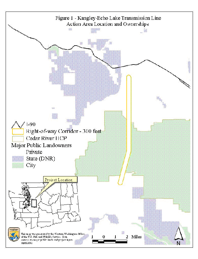
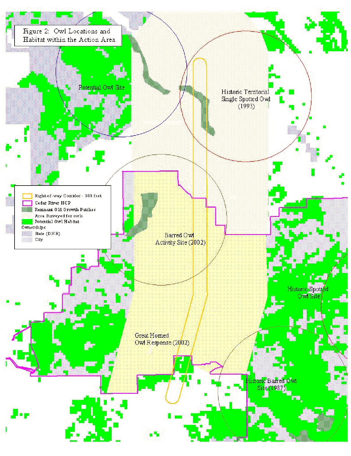