![[HOME]](/netaicon/homeicon.gif)
![[SEARCH]](/netaicon/srchpage.gif)

![[CURR_LIST]](/netaicon/curlist.gif)


![[BOTTOM]](/netaicon/bottom.gif)
![[HELP]](/netaicon/help.gif)
Seattle City Council Bills and Ordinances
Information modified on April 9, 2007; retrieved on May 22, 2025 2:30 PM
Ordinance 122371
Introduced as Council Bill 115847
Title | |
|---|---|
| AN ORDINANCE relating to City of Seattle property commonly known as the "Northgate South Lot;" declaring as surplus certain portions of the Northgate South Lot to utility and other City needs; authorizing a lot boundary adjustment of the Northgate South Lot; authorizing the grant and acceptance of deeds and easements; and authorizing the transfer of jurisdiction of certain Northgate South Lot property from Seattle Public Utilities to the Seattle Department of Transportation. | |
Description and Background | |
|---|---|
| Current Status: | Passed |
| Fiscal Note: | Fiscal Note to Council Bill No. 115847 |
| Index Terms: | NORTHGATE, SALES, GRANTS, SEATTLE-PUBLIC-UTILITIES, THORNTON-CREEK, DRAINAGE |
| References: | Related: Res 30642; Ord 122110, 121546 |
Legislative History | |
|---|---|
| Sponsor: | CONLIN |
| Date Introduced: | March 19, 2007 |
| Committee Referral: | Environment, Emergency Management and Utilities |
| City Council Action Date: | April 2, 2007 |
| City Council Action: | Passed |
| City Council Vote: | 9-0 |
| Date Delivered to Mayor: | April 3, 2007 |
|
Date Signed by Mayor: (About the signature date) | April 6, 2007 |
| Date Filed with Clerk: | April 6, 2007 |
| Signed Copy: | PDF scan of Ordinance No. 122371 |
Text | |
|---|---|
|
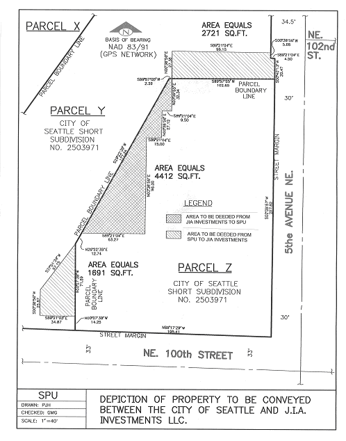
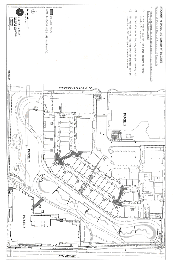
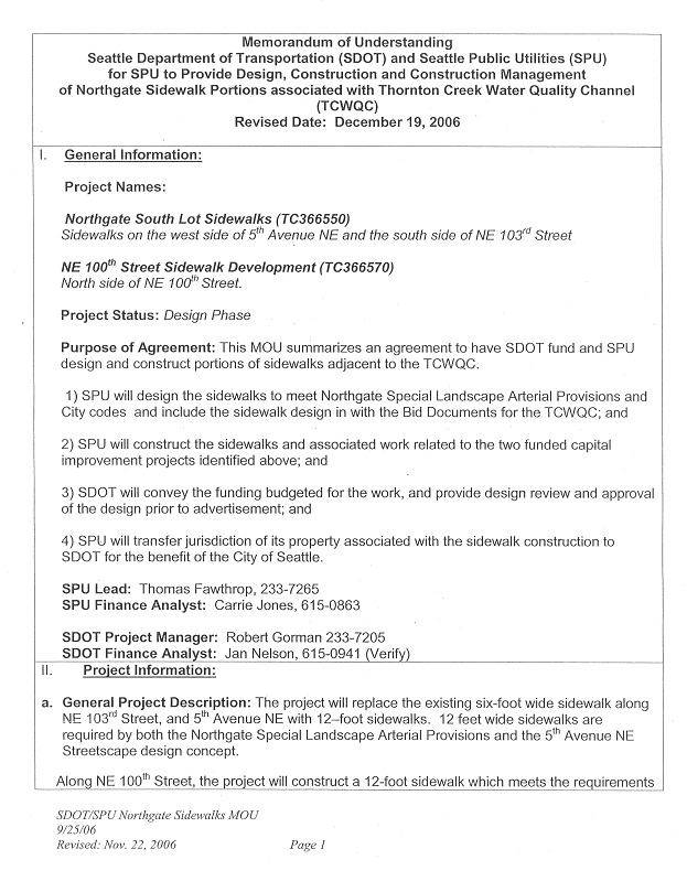
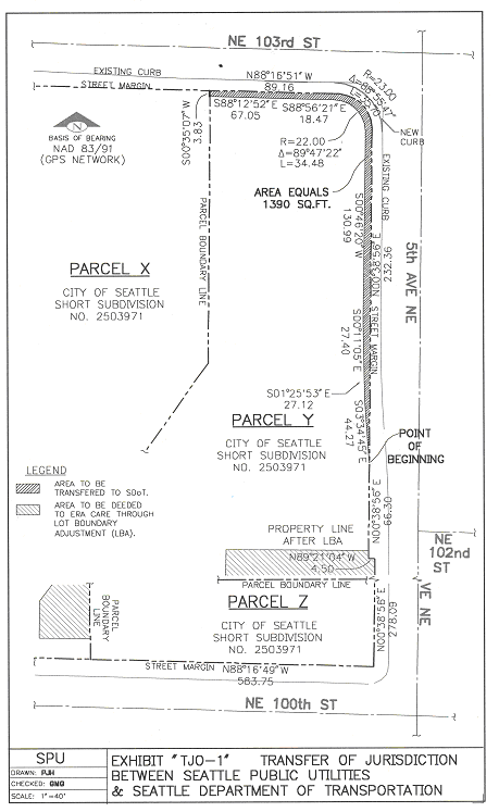
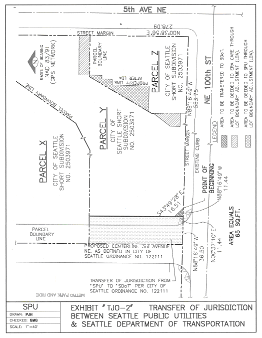
AN ORDINANCE relating to City of Seattle property commonly known as the "Northgate South Lot;" declaring as surplus certain portions of the Northgate South Lot to utility and other City needs; authorizing a lot boundary adjustment of the Northgate South Lot; authorizing the grant and acceptance of deeds and easements; and authorizing the transfer of jurisdiction of certain Northgate South Lot property from Seattle Public Utilities to the Seattle Department of Transportation. WHEREAS, pursuant to Ordinance 121548, the City purchased from Northgate Mall Partnership, a subsidiary of Simon Property Group, L.P. ("Simon"), approximately 2.7 acres of property ("Parcel B") for the purpose of open space and stormwater improvements for the benefit of Thornton Creek; and WHEREAS, Northgate South Commons, LLC, a subsidiary of Lorig Associates, LLC ("Lorig") purchased from Simon approximately 5.9 acres of property ("Parcel A"); and WHEREAS, Seattle Public Utilities ("SPU") entered into a Memorandum of Understanding with Lorig pursuant to Ordinance 121546 and together submitted a short plat application to the City's Department of Planning and Development requesting it to subdivide Parcels A and B into three parcels, Parcels X, Y, and Z, commonly referred to as the "Northgate South Lot;" and WHEREAS, J.I.A. Investments, LLC, a subsidiary of ERA Living, Inc. ("ERA Living") purchased Parcel Z from Lorig for the purpose of constructing approximately 129 senior housing units; and WHEREAS, pursuant to the Development Contract dated June 1, 2006, ERA Living and SPU agree that the grant and acceptance of easements are mutually beneficial and no additional financial or other consideration is necessary; and WHEREAS, ERA Living desires to increase its building footprint slightly to the north and to the west in order to construct 14 additional units of senior housing; and WHEREAS, the City owns Parcel Y and desires to improve the design of the public open space available in the Thornton Creek Water Quality Channel Project ("TCWQC"); and WHEREAS, the City and ERA Living desire to reconfigure approximately 4,400 square feet between Parcels Y and Z through a lot boundary adjustment in order to fulfill both parties' objectives; and WHEREAS, SPU has determined that it is in the best interest of its customers to minimize any risk, obligation and expenditure of drainage and wastewater funds to maintain property that is not related to the core function of the water quality improvement purpose of TCWQC, and as such desires to transfer jurisdiction of certain Northgate South Lot property to the Seattle Department of Transportation ("SDOT") for the purpose of street improvements and maintenance; NOW THEREFORE, BE IT ORDAINED BY THE CITY OF SEATTLE AS FOLLOWS: Section 1. Pursuant to the provisions of RCW 35.94.040, and after a public hearing, those portions legally described as follows, of the City's interest in Parcel Y of City of Seattle Short Subdivision 2503971, are hereby found and declared to be no longer required for providing municipal utility service and to be surplus to the City's needs: That Portion of Parcel Y, said Short Subdivision No. 2503971, described as follows: Commencing at the most southerly southeast corner of said parcel Y, Thence North 00 degrees 07' 38" West 14.25 feet along the southeasterly line thereof to the True Point of Beginning; Thence continuing North 00 degrees 07' 38" West 71.89 feet along said southeasterly line to an angle point therein; Thence leaving said southeasterly line South 37 degrees 01' 34" West 57.15 feet; Thence South 00 degrees 38' 56" West 25.87 feet to a point which bears North 89 degrees 21' 04" West from the true point of beginning; Thence South 89 degrees 21' 04" East 34.87 feet to the true point of beginning; The Parcel described above contains 1692 square feet (0.039 acres), more or less. AND That Portion of Parcel Y, said Short Subdivision No. 2503971, described as follows: Beginning at the most easterly southeast corner of said Parcel Y, and the Point of Beginning; Thence South 89 degrees 57' 05" West 102.65 feet along the southeasterly line; Thence leaving said southeasterly line North 00 degrees 38' 56" East 27.38 feet; Thence South 89 degrees 21' 04" East 98.15 feet to the easterly line of said Parcel Y; Thence southerly along said easterly line the following three courses: Thence South 00 degrees 38' 56" West 5.66 feet; Thence South 89 degrees 21' 04" East 4.50 feet; Thence South 00 degrees 38' 56" West 20.47 feet to the Point of Beginning; The Parcel described above contains 2721 square feet (0.062 acres), more or less. Section 2. The Director of Seattle Public Utilities, or his designee, is hereby authorized to execute, for and on behalf of the City, a Limited Warranty Deed, substantially in the form attached hereto as Attachment 1, conveying those portions legally described in Section 1, of the City's interest in Parcel Y of City of Seattle Short Subdivision 2503971, as shown on Attachment 2 hereto, to J.I.A. Investments, LLC, a Washington limited liability company. Section 3. The Director of Seattle Public Utilities, or his designee, is authorized to accept and record, on behalf of the City of Seattle, a Statutory Warranty Deed from J.I.A. Investments, LLC, substantially in the form attached hereto as Attachment 3, to that portion of Parcel Z of City of Seattle Short Subdivision 2503971 legally described as follows, which property shall be placed under the jurisdiction of Seattle Public Utilities: That Portion of Parcel Z, said Short Subdivision No. 2503971, described as follows: Commencing at the northeast corner of said Parcel Z, Thence South 89 degrees 57' 05" West 102.65 feet along the north line thereof to the True Point of Beginning; Thence continuing South 89 degrees 57' 05" West 2.59 feet along said north line to the northwesterly line of said Parcel Z; Thence South 29 degrees 22' 35" West 177.24 feet along said northwesterly line; Thence leaving said northwesterly line South 89 degrees 21' 04" East 63.27 feet; Thence North 00 degrees 38' 56" East 96.00 feet; Thence South 89 degrees 21' 04" East 15.00 feet; Thence North 00 degrees 38' 56" East 27.12 feet; Thence South 89 degrees 21' 04" East 9.50 feet to a point which bears South 00 degrees 38' 56" West from the true point of beginning; Thence North 00 degrees 38' 56" East 32.33 feet to the True Point of Beginning; The Parcel described above contains 4412 square feet (0.101acres), more or less. Section 4. The Director of Seattle Public Utilities, or his designee, is authorized on behalf of the City of Seattle to execute the grant of permanent easements to J.I.A. Investments, LLC upon such terms as are agreed to by the parties thereto and generally described as shown in Attachment 4. Section 5. The City hereby finds and declares that the property legally described in Section 6 is not required for utility purposes. SPU will benefit from the transfer of jurisdiction of said property to SDOT because it fulfills SPU's policy of limiting the expenditure of drainage and wastewater funds for ongoing maintenance and exposure to liability for property that is not related to the core function of water quality improvements. SPU will construct sidewalks on said property, and SDOT will fund the construction and maintenance, pursuant to the Memorandum of Understanding attached hereto as Attachment 5. Section 6. The Director of Seattle Public Utilities, or his designee, is hereby authorized to transfer to the Seattle Department of Transportation, and the Director of Seattle Department of Transportation is hereby authorized to accept for street purposes, jurisdiction over those portions of Parcel Y of the Northgate South Lot legally described as follows: That Portion of Parcel Y of the City of Seattle Short Subdivision No. 2503971 recorded under Recording No. 20060601900001, Records of King County, Washington, situated in the Northeast 1/4, of the Northwest 1/4 of Section 32, Township 26 North, Range 4 East of the Willamette Meridian in the City of Seattle, described as follows: Commencing at the Southeast corner of Parcel Z of said Short Subdivision, also described as the intersection of the west margin of 5th Avenue NE with the north margin of NE 100th Street; Thence North 0 degrees 38' 56" East a distance of 278.09 feet along the said margin of 5th Avenue NE and the east line of said Parcel Z; Thence North 89 degrees 21' 04" West a distance of 4.50 feet along said street margin; Thence North 0 degrees 38' 56" East a distance of 66.30 feet along said street margin to the Point of Beginning; Thence continuing along said street margin North 0 degrees 38' 56" East a distance of 232.36 feet to the beginning of a 23.00 foot radius tangent curve to the left, which center bears North 89 degrees 21' 04" West; Thence northwesterly along said street margin and the arc of said curve, a distance of 35.70 feet through a central angle of 88 degrees 55' 47"; Thence North 88 degrees 16' 51" West a distance of 89.16 feet along said street margin to the west line of Parcel Y; Thence South 0 degrees 35' 07" West a distance of 3.83 feet along the west line of said parcel; Thence South 88 degrees 12' 52" East a distance of 67.05 feet; Thence South 88 degrees 56' 21" East a distance of 18.47 feet to the beginning of a 22.00 foot radius non-tangent curve to the right, which center bears South 1 degrees 03' 53" West; Thence southeasterly along the arc of said curve a distance of 34.48 feet through a central angle of 89 degrees 47' 22"; Thence South 0 degrees 46' 20" West a distance of 130.99 feet; Thence South 0 degrees 11' 05" East a distance of 27.40 feet; Thence South 1 degrees 25' 53" East a distance of 27.12 feet; Thence South 3 degrees 34' 43" East a distance of 44.28 feet to the point of beginning; The parcel described above contains 1398 square feet, more or less AND That Portion of Parcel Y of the City of Seattle Short Subdivision No. 2503971 recorded under Recording No. 20060601900001, Records of King County, Washington, situated in the Northeast 1/4, of the Northwest 1/4 of Section 32, Township 26 North, Range 4 East of the Willamette Meridian in the City of Seattle, described as follows: Commencing at the Southeast corner of Parcel Z of said Short Subdivision, also described as the intersection of the north margin of NE 100th Street with the west margin of 5th Avenue NE; Thence North 88 degrees 16' 49" West a distance of 583.75 feet along said margin of NE 100th Street to the Point of Beginning; Thence continuing along said north street margin North 88 degrees 16' 49" West a distance of 11.44 feet to a point 36.50 feet from the southwest corner of Parcel Y and the intersection of the north margin of NE 100th Street and the east margin of 3rd Avenue NE as dedicated in City of Seattle Ordinance Number 122111, dated May, 22nd 2006; Thence North 0 degrees 37' 10" East a distance of 11.44 feet along the easterly margin of said 3rd Avenue NE; Thence South 43 degrees 49' 28" East a distance of 16.34 feet to the point of beginning; The parcel described above contains 65 square feet, more or less. Section 7. The parcels legally described in Section 6, and depicted in Attachments 6 and 7 hereto, are dedicated for street purposes and are laid off, opened, widened and established as N.E. 103rd Street between 5th Avenue N.E. and 3rd Avenue N.E., 5th Avenue N.E. between N.E. 103rd Street and N.E. 100 Street, 3rd Avenue N.E. between N.E. 100th Street and N.E. 103rd Street, and N.E. 100th Street at 3rd Avenue N.E. The segments of N.E. 100th Street, N.E. 103rd Street and 3rd Avenue N.E. described in the previous sentence are designated as Minor Arterials, and the segment of 5th Avenue N.E. described in the previous sentence is designated as a Major Arterial.. Section 8. This ordinance shall take effect and be in force thirty (30) days from and after its approval by the Mayor, but if not approved and returned by the Mayor within ten (10) days after presentation, it shall take effect as provided by Municipal Code Section 1.04.020. Passed by the City Council the ____ day of _________, 2007, and signed by me in open session in authentication of its passage this _____ day of __________, 2007. _________________________________ President __________of the City Council Approved by me this ____ day of _________, 2007. _________________________________ Gregory J. Nickels, Mayor Filed by me this ____ day of _________, 2007. ____________________________________ City Clerk (Seal) Attachment 1: Form of Limited Warranty Deed from the City to J.I.A. Investments, LLC. Attachment 2: Depiction of Property to be conveyed between the City and J.I.A. Investments, LLC. Attachment 3: Form of Statutory Warranty Deed from J.I.A. Investments, LLC to the City. Attachment 4: Diagram and Summary of Easements. Attachment 5: Memorandum of Understanding Between SDOT and SPU. Attachment 6: Depiction of Parcel 1 to be transferred from SPU to SDOT (TJO-1). Attachment 7: Depiction of Parcel 2 to be transferred from SPU to SDOT (TJO-2). SPU Northgate Thornton Creek BLA ORD.doc March 2, 2006 version #8 1 Attachment 1: Form of Limited Warranty Deed from the City to J.I.A. Investments, LLC. Recording Requested By And When Recorded Mail To: J.I.A. INVESTMENTS, LLC ? James D. Clack Dorsey & Whitney LLP 1420 Fifth Avenue #3400 Seattle, WA 98101-4010 Reference #s of Document Released: NA Grantor: The City of Seattle Grantee: J.I.A. INVESTMENTS, LLC Legal Description (abbreviated): Pt Lot Y, Short Subdivision 2503971 Assessor's Tax Parcel ID# Pt. of 3226049561 LIMITED WARRANTY DEED THE CITY OF SEATTLE, a Washington municipal corporation ("Grantor"), for and in consideration of ten and 00/100 Dollars ($10.00) to it paid by J.I.A. INVESTMENTS, LLC, a Washington limited liability company ("Grantee"), the receipt of which is hereby acknowledged, does hereby grant and convey, with limited warranty covenants, to the Grantee, the premises described in Exhibit A attached hereto and made a part hereof ("Property") together with all of the privileges and appurtenances to the same belonging, to have and to hold the same to Grantee, its successors and assigns forever. Grantor, for itself and for its successors, hereby warrants with limited warranty covenants, with the Grantee, its successors and assigns forever, that it is lawfully seized of the Property in fee simple and that it will defend the same from and against the claims and demands of only Grantor and all persons claiming by, through, or under Grantor, but not against the claims of any others whomsoever, and that this conveyance of the Property is made subject to (a) all liens and encumbrances created or assumed by Grantee; (b) zoning ordinances; (c) legal highways; (d) covenants, restrictions, conditions and other matters currently of record; (e) real estate taxes and assessments not yet due and payable; and (f) all matters which may be disclosed by an accurate survey of the Property. In Witness Whereof, Grantor has caused its name to be hereunto subscribed this ___ day of _________, 2007, by its duly authorized official. GRANTOR The City of Seattle Chuck Clarke, Director Seattle Public Utilities STATE OF ) )ss. COUNTY OF ) I certify that I know or have satisfactory evidence that Chuck Clarke signed this instrument, on oath stated that he was authorized to execute the instrument and acknowledged it as the Director of Seattle Public Utilities of The City of Seattle, to be the free and voluntary act of such party for the uses and purposes mentioned in the instrument. Dated_______________________ NAME (Print) NOTARY PUBLIC in and for the State of My appointment expires Exhibit A Legal Description That Portion of Parcel Y, said Short Subdivision No. 2503971, described as follows: Commencing at the most southerly southeast corner of said parcel Y, Thence North 00 degrees 07' 38" West 14.25 feet along the southeasterly line thereof to the True Point of Beginning; Thence continuing North 00 degrees 07' 38" West 71.89 feet along said southeasterly line to an angle point therein; Thence leaving said southeasterly line South 37 degrees 01' 34" West 57.15 feet; Thence South 00 degrees 38' 56" West 25.87 feet to a point which bears North 89 degrees 21' 04" West from the true point of beginning; Thence South 89 degrees 21' 046" East 34.87 feet to the true point of beginning; The Parcel described above contains 1692 square feet (0.039 acres), more or less. AND That Portion of Parcel Y, said Short Subdivision No. 2503971, described as follows: Beginning at the most easterly southeast corner of said Parcel Y, and the Point of Beginning; Thence South 89 degrees 57' 05" West 102.65 feet along the southeasterly line ; Thence leaving said southeasterly line North 00 degrees 38' 56" East 27.38 feet; Thence South 89 degrees 21' 04" East 98.15 feet to the easterly line of said Parcel Y; Thence southerly along said easterly line the following three courses: Thence South 00 degrees 38' 56" West 5.66 feet; Thence South 89 degrees 21' 04" East 4.50 feet; Thence South 00 degrees 38' 56" West 20.47 feet to the Point of Beginning; The Parcel described above contains 2721 square feet (0.062 acres), more or less. Page 1 of 3 Attachment 1 Form of Limited Warranty Deed from City to JIA Investments LLC Attachment 2: Depiction of Property to be conveyed between the City and J.I.A. Investments, LLC. Attachment 3: Form of Statutory Warranty Deed from J.I.A. Investments, LLC to the City. Recording Requested By And When Recorded Mail To: City of Seattle Seattle Public Utilities Real Estate Services P.O. Box 34018 Seattle, WA 98124-4018 Reference #s of Document Released: NA Grantor: J.I.A. INVESTMENTS, LLC Grantee: City of Seattle Legal Description (abbreviated): Pt. of Lot Z, Short Subdivision 2503971 Assessor's Tax Parcel ID# Pt. of 3226049568 STATUTORY WARRANTY DEED THE GRANTOR, J.I.A. INVESTMENTS, LLC, a limited liability company, for and inconsideration of ten and 00/100 Dollars ($10.00) and other good and valuable consideration, the receipt and sufficiency of which is hereby acknowledged, conveys and warrants to THE CITY OF SEATTLE, a Washington municipal corporation, the real property situated in King County, Washington, which is more particularly described on attached Exhibit A, subject to all easements, restrictions, covenants, conditions and other matters of record. DATED this ____ day of __________, 2007. GRANTOR: J.I.A. INVESTMENTS, LLC a Washington limited liability company By: Rebecca Almo, Manager STATE OF WASHINGTON ) : ss. County of King ) I certify that I know or have satisfactory evidence that Rebecca Almo is the person who appeared before me, and said person acknowledged that she signed this instrument, on oath stated that she was authorized to execute the instrument and acknowledged it as the Manager of J.I.A.INVESTMENTS, LLC to be the free and voluntary act of such party for the uses and purposes mentioned in the instrument. GIVEN under my hand and official seal the day and year last above written. Notary (print name) Notary Public in and for the State of Washington, residing at My Appointment expires Exhibit A Legal Description That Portion of Parcel Z, said Short Subdivision No. 2503971, described as follows: Commencing at the northeast corner of said Parcel Z, Thence South 89 degrees 57' 05" West 102.65 feet along the north line thereof to the True Point of Beginning; Thence continuing South 89 degrees 57' 05" West 2.59 feet along said north line to the northwesterly line of said Parcel Z; Thence continuing South 29 degrees 22' 35" West 177.24 feet along said northwesterly line; Thence leaving said northwesterly line South 89 degrees 21' 04" East 63.27 feet; Thence North 00 degrees 38' 56" East 96.00 feet; Thence South 89 degrees 21' 04" East 15.00 feet; Thence North 00 degrees 38' 56" East 27.12 feet; Thence South 89 degrees 21' 04" East 9.50 feet to a point which bears South 00 degrees 38' 56" West from the true point of beginning; Thence North 00 degrees 38' 56" East 32.33 feet to the True Point of Beginning; The Parcel described above contains 4412 square feet (0.101acres), more or less. Page 1 of 3 Attachment 4: Diagram and Summary of Easements. Attachment 5: Memorandum of Understanding Between SDOT and SPU Attachment 6: Depiction of Parcel 1 to be transferred from SPU to SDOT (TJO-1) Attachment 7: Depiction of Parcel 2 to be transferred from SPU to SDOT (TJO-2) |
|
Attachments |
|---|
![[TOP]](/netaicon/toppg.gif)