![[HOME]](/netaicon/homeicon.gif)
![[SEARCH]](/netaicon/srchpage.gif)

![[CURR_LIST]](/netaicon/curlist.gif)


![[BOTTOM]](/netaicon/bottom.gif)
![[HELP]](/netaicon/help.gif)
Seattle Comptroller/Clerk Files Index
Information modified on July 5, 2013; retrieved on July 15, 2025 10:59 PM
Clerk File 313128
Title | |
|---|---|
Description and Background | |
|---|---|
| Current Status: | Filed |
| References: | |
Legislative History | |
|---|---|
| Date Filed with Clerk: | July 3, 2013 |
Text | |||||||||||||||||||||||||||||||||||||||||||||||||||||||||||||||||||||||||||||||||||||||||||||||||||||||||||||||||
|---|---|---|---|---|---|---|---|---|---|---|---|---|---|---|---|---|---|---|---|---|---|---|---|---|---|---|---|---|---|---|---|---|---|---|---|---|---|---|---|---|---|---|---|---|---|---|---|---|---|---|---|---|---|---|---|---|---|---|---|---|---|---|---|---|---|---|---|---|---|---|---|---|---|---|---|---|---|---|---|---|---|---|---|---|---|---|---|---|---|---|---|---|---|---|---|---|---|---|---|---|---|---|---|---|---|---|---|---|---|---|---|---|---|
|
REPORT ON DESIGNATION LPB 622/12 Name and Address of Property: Charles P. Dose House 2121 31st Avenue South Legal Description: Lot 5 & south 7' of Lot 6 of Block 4 of C.P. Dose's Lake Washington Addition Replat of Blks 4 & 5, as thereof recorded in Volume 15 of plats, page 99, as situated in the City of Seattle, King County, Washington. At the public meeting held on December 19, 2012, the City of Seattle's Landmarks Preservation Board voted to approve designation of the Charles P. Dose House at 2121 31st Avenue South as a Seattle Landmark based upon satisfaction of the following standards for designation of SMC 25.12.350: B. It is associated in a significant way with the life of Charles P. Dose, important to the history of the City; C. It is associated in a significant way with a significant aspect of the cultural, political, or economic heritage of the Mt. Baker community; D. It embodies the distinctive visible characteristics of an architectural style, period, or of a method of construction; and E. It is an outstanding work of Charles C. Dose. ARCHITECTURAL DESCRIPTION Site, Setting & Neighborhood Physical Context The Charles P. Dose House is located in the northern part of the greater Mount Baker neighborhood in southeast Seattle. The neighborhood is bounded to the east by Lake Washington, to the north by Judkins Street, to the south by Charlestown Street, and to the west by Martin Luther King Jr. Way (north of Cheasty Boulevard) and Rainier Avenue (south of Cheasty Boulevard). The Mount Baker area is defined by two north-south ridges: one runs along 31st Avenue S. from Judkins Street to Mount Baker Boulevard and the other runs between Mount Baker Park and Lake Washington along Mount St. Helens Place and Hunter Boulevard. These ridges offer dramatic east-facing views to Lake Washington and the Cascade Range. The 200-acre Mount Baker Park Addition (platted 1907) encompasses a 70 block area within the neighborhood and its picturesque layout and planning was designed to be incorporated into the greater Seattle Parks and Boulevard system planned by the Olmsted Bros. in 1903 and 1908. Nearby neighborhood components of that plan include Lake Washington Boulevard, Coleman Park, Mount Baker Park and Mount Baker Boulevard. The C.P. Dose House is situated within the 10-acre plat of C. P. Dose's Lake Washington Addition (platted 1905) and on the high west side of the 31st Avenue S. ridge approx.0.2 miles west and uphill from Mount Baker Park and Lake Washington Boulevard. The house is located at the NW corner of the intersection of 31st Avenue S. and S. Walker Street. Two brick bollards are located nearby on the east side of 31st Avenue S.; they mark the entrance to Dose Terrace. The eastern four block extension of S. Walker Street became known as Dose Terrace after 1908 when Mr. Dose donated his lakeshore parcels to the Seattle Park Board. A formal stairwell leading to Mount Baker Park and the Boulevard is located at the foot of Dose Terrace. The subject house is formally oriented toward 31st Avenue S., which is a relatively busy north-south arterial and served historically as a street car route. The adjacent blocks to the west, north, east and south are dominated by a fairly standard grid street system with dense residential development along most of the streets. The immediate area is characterized by single family residences including other historic and older residential properties, several of which are also directly associated with either C.P. Dose or his son C.C. Dose. While numerous historic properties in neighborhood have been identified through historic resource survey and inventory efforts, very few have been formally recognized. The following neighborhood properties are City landmarks: the Story Cottages (1706-1816 Lake Washington Boulevard and 1725 & 1729 36th Avenue S., built 1910-15), William Thompson Residence (3119 S. Day Street, built 1897), the Krauss/Andersson House (2812 Mount St. Helens Place, built 1911) and Franklin High School (3013 S. Mount Baker Boulevard, built 1910-11). The C.P. Dose House was surveyed in the 2003 historic resource inventory of the Mount Baker neighborhood and identified as potentially eligible for local landmark designation. The C.P. Dose House is located on a rectangular lot measuring approx. 50' x 100' and is setback from the adjacent street intersection and common property lines. The residence is situated several feet above the grade of the adjacent sidewalks; thus, the south and east edges of the site are bounded by retaining walls composed of large boulders. The retaining walls are all currently covered by English Ivy. Well established deciduous trees are planted on the adjacent parking strips along east and south sides of the site and tend to obscure views of the house, as do a large shrub and tree adjacent to the east elevation. Formal entry to the house from 31st Avenue S. is via a set of modern exposed aggregate concrete stairs that are adjacent to the north property line. A short driveway provides access to the basement level garage from S. Walker Street. Extant portions of original/historic stone paving are located at the east side of the entrance porch and along the north side of the residence. Non-historic hedges and planting materials are located at the east and north perimeter of the site and non-historic fencing is located along the entire western 30-foot end of the site. The west property line abuts an adjacent residential parcel and there is no alley. Current Exterior Appearance Design Character Typical Extant Original Features & Finishes The Charles P. Dose House is a 2-1/2 story wood-frame structure with a concrete foundation and a basement level with crawl space. The exterior of the house is very well preserved and exhibits numerous original architectural features and finishes drawn from the popular late 19th C. English Arts & Crafts design mode -described as the "Modern English style" in the 120-page plan book catalog Architecture of Dose, West & Reinhold published by C.C. Dose in 1908. The exterior is distinguished by a prominent 2-1/2 story front-gable building form and a full width entrance porch. The upper portions of the entire exterior are typically clad with rustic concrete stucco and a half-timber treatment (above second floor line). The base or first floor level is clad with variegated red and clinker brick veneer. The exposed portions of the concrete foundation walls are coated with a smooth concrete stucco finish that is scored to create the appearance of cut regularly coursed stonework. The house exhibits highly distinctive exterior features included projecting bay windows with hipped roofs at the south and the north elevations, wide open eaves and overhangs, wide barge boards with open trefoil treatment at the flared tails; this latter detail is emblematic of several other known residential designs credited to C.C. Dose & Co., Architects. All of the main roof and dormer gables include elaborate heavy kneebraces. The principal front-gable roof form is further complicated by wide gabled wall dormers at the south and north elevations as well as smaller gabled roof dormers at the south and north elevations, all of which exhibit homogeneous roof features and architectural details. The roof was originally clad with Cedar shingles: however, it is now covered by an unobtrusive asphalt shingle roofing product. Two original chimneys exhibit variegated red brick and clinker brick masonry and corbelled caps; the larger one to the south serves a double fireplace and the smaller one to the north originally served the basement level laundry and the kitchen. The house exhibits a variety of wooden window sash and window types: simple three-part hopper type sash are typically located at the basement level, arched ventilation openings are located below the entry porch, a large cottage type window with multi-pane upper sash is located at the entrance porch and simple one-over-one double hung sash are typically located at the second floor level. Two types of ornate diamond-pattern casement sash members are located at various attic level window openings. Highly decorative and elaborate fixed stained glass window panels are located at various first floor window openings: some panels are within sets of fixed sash located at the south and north elevations and others are within a particularly distinctive bay window at the south elevation. Protective panels have been added to the exterior sides of these windows. Ornate leaded and beveled glass sidelights also distinguish the front entry doorway. East Elevation (facade) The principal East elevation or facade is dominated by a prominent 2-1/2 story front-gable and a full width porch. The porch roof is a gable-on-hip form that includes decorative soffit brackets and is supported by multiple square columns. The porch is entered via central set of flared concrete entry stairs with cheeks. The stair entry is flanked by sets of square columns and the corners of the porch are accentuated by sets of three square columns. A large cottage type window with multi-pane upper sash and a beaded board ceiling with a diamond-pattern inset (for the porch light) are also located at the entrance porch. A set of ornate leaded and beveled glass sidelights flank the original painted Fir entry door at the north side of the porch. The main gable and the porch gable exhibit the typical highly distinctive detail wide barge boards with an open trefoil treatment at the flared tails -found throughout the exterior design. The main roof gable exhibits wide soffits supported by heavy kneebraces. Two sets of double-hung windows are located at the second floor level. Diamond-pattern casement sash members are centrally located within the gable end. North Elevation The North elevation exhibits a highly decorative and elaborate stained glass window panel at the first floor level (east end) and a shallow one-story square bay window at the center of the elevation. The hipped roof at the bay window exhibits typical beaded board soffits and decorative soffit brackets. Windows at the first level are typically set with brick surrounds and include smooth sandstone sills. This elevation is dominated by a wide wall dormer at the center of second floor level that is flanked to the east by a single roof dormer at the attic level. The wide window dormer includes a band of three double-hung windows. All of the dormers exhibit kneebraces and highly distinctive details wide barge boards with an open trefoil treatment at the flared tails -as noted above. The onestory brick clad wall at the east end of this elevation is a surviving portion of the original rear porch. West Elevation The West or rear elevation is altered to some degree. See section below describing NonHistoric Exterior Alterations. Despite the modern alterations, the original brick and half-timber cladding, fenestration, window sash and other details remain intact and well preserved. This elevation exhibits typical original roof details, double-hung window sash and sandstone sills. South Elevation This prominent elevation exhibits highly distinctive architectural features in addition to intact original cladding materials. This elevation is dominated by a wide wall dormer at center of second floor level that is flanked by two roof dormers at the attic level. The wide window dormer includes a band of three double-hung windows. All of the dormers exhibit elaborate, heavy kneebraces and highly distinctive details wide barge boards with an open trefoil treatment at the flared tails -as noted above. A particularly distinctive bay window with elaborate stained panels is located at the west end of the first floor level of this elevation. A set of highly decorative and elaborate stained glass window panels flank a bay window (that includes simple stained glass panels) at the east end of the first floor level of this elevation. The doors of a double garage are located at the east end of the basement floor level of this elevation. The construction of the adjacent bolder retaining walls and the garage opening appear to have been an historic alteration made prior to 1920. See section below describing Historic Exterior Alterations. Historic Exterior Alterations The basement level two-car garage, which is located at the east end of the basement level and accessed via a short driveway from S. Walker Street, appears to have been added prior to 1920. The adjacent boulder retaining walls also appears to have been constructed at that time. The two-car garage door opening and the retaining wall are not visible in historic photographs taken shortly after the completion of construction ca.1910. The King County property record card and photograph indicate that by 1937 the garage with driveway access from S. Walker Street had been constructed. It seems likely that the garage was added prior to the change of ownership from C. P. Dose to Allan T. and Ethel E. Williamson in April 1920, as the card indicates that the house had not been remodeled, a fact that the Williamsons (who owned the house until 1963) would have reported. Non-Historic Exterior Alterations The building site exhibits various changes and alterations made by the current owner. These changes include the construction of a boulder retaining wall along the east property line; this wall is very similar in character to the historic boulder wall located along the south side of the property. The original lower central stairway (leading from the old curved pathway to the sidewalk at 31st Avenue S.) is encapsulated within the backfill area behind the boulder wall. This work included the construction of the current concrete stairway that is adjacent to the north property line. The level front yard area behind the retaining wall at the SE corner of the lot includes a dense hedge border and other plantings established after the construction of the wall. The rear yard area is currently enclosed by a non-historic wooden fence. The West elevation exhibits two major modern alterations. The kitchen space at the north side of this elevation was remodeled and expanded in 1980; the work involved the removal of exterior walls at the original rear porch/cold storage area and the conversion of the porch to useable interior kitchen space. The former porch space was expanded approx. 4' to the south and modern windows and skylights were installed. However, the original brick wall at the north side was retained. At the second floor level an original west-facing open balcony was converted into an enclosed conservatory similar in design to the modern kitchen addition. Minor window alterations (and some window sash replacement) have occurred. The original diamond pattern casement sash members at the attic level of the East elevation front gable were replaced with a similar wooden window product and some of the double-hung windows at the south elevation have been replaced in-kind. Two small rectangular roof skylights have been installed at the attic level. Significant Interior Features and/or Finishes Spatial configuration The interior spaces, features, and finishes including historic lighting fixtures are very well preserved. The first floor level interior included four highly intact formal living spaces: a reception hall with main stairwell, a large dining room, a particularly large living room and a small library/study. A small powder room (that may not have been part of the original design) is located between the library and the dining room; this space may have originally been a closet or a small passageway between the library and the dining room. The kitchen has been remodeled and expanded; however, original pantry cabinets and two separate doorways leading to stairway to upper and lower floor levels remain intact. The second floor level interior includes several intact private living spaces: a spacious main stairway landing, a wide hallway corridor and four bedrooms. Stairways leading down to the kitchen and up to the attic level and a laundry chute are located at the west end of the hallway. A large remodeled bathroom is situated at the NW corner of the second floor level. Ceilings at both floor levels are typically 10' in height and all of the major interior spaces were finished with lath and plaster and unpainted or painted Fir details. Hardwood floors are typical throughout the first floor level and Fir floors are typical at the second floor level. A variety of ornate original light fixtures are located at both the first and second floor levels. Original circulating hot water gravity radiators also remain in place throughout the house. The attic level is a simply finished large open room that includes the valleys and windows of the two wall dormers. The valleys of two of the roof dormers are enclosed within the space along the eaves and one roof dormer is now opened to a bedroom space at the southwest corner of the second floor level. The unfinished basement level includes the original coal-fired hot water boiler furnace (that has been converted to a high efficiency oil burner), a fuel/coal room with former coal chute that is now used as a workshop, a laundry room with original laundry tray and laundry chute, a small toilet room and storage room. The NE portion of the basement level is crawl space. The remainder of the basement level may have originally been crawl space; however, a two-car garage was added at the SE side of the basement level during the historic period. Features & Finishes of Significance Main Stairwell Open stairwell within reception hall and second floor landing space exhibits original stained Fir handrails, spindles, newel posts with distinctive Arts & Crafts detailing. Stained Fir woodwork and doors (including hardware) Original stained Fir trim (running, standing and cove mould) is located within the reception hall and second floor landing space. This space also includes original stained Fir door and window surrounds, a stained Fir single panel closet door and a stained Craftsman style entry door both with original brass hardware. Painted Fir woodwork and doors (including unpainted original hardware) Original Fir trim and other architectural details (including running, standing and cove mould) that has been painted are located throughout the remainder of all of the rooms on the first and second floor. These features include original Craftsman style Fir doors with original brass hardware (brass knobs at first floor & glass knobs at second floor), all window and door surrounds, plate rails (in dining room) and shelving (in library). Leaded & beveled glass sidelights Ornate leaded and beveled glass sidelights flank the original Fir entry door. Bay windows Intact original bay windows are located in the Living Room, Dining Room and Library/Study. Stained glass window panels Highly distinctive fixed stained glass window panels are located at window openings in the Main Stairwell/Reception Hall and Living Room and within the bay window in the Library/Study. Distinctive stained glass window panels are also located within the bay window at the Living Room. Beamed ceilings Distinctive original beamed ceilings are located within the Library/Study and the Dining Room. Brick fireplaces Original brick fireplaces with simple tile hearths are located within the Living Room and the Library/Study. The brick has been painted. Cabinetry w/ leaded & stained glass fronts Highly distinctive original cabinetry w/ leaded & stained glass fronts is located within the Dining Room and the Library/Study. Other cabinetry Distinctive original unpainted Fir cabinetry is located within the Stair Landing space (second floor) and some original painted Fir cabinetry is located within the kitchen. Hardwood floors Original hardwood floors with decorative inlaid borders are located throughout the first floor level with the exception of the kitchen. Lighting Fixtures of Significance The C.P. Dose House continues to exhibit a variety of historic lighting fixtures that appear to have been installed at the time of construction. Several of the fixtures are highly ornate and distinctive in their design. Many of the fixtures appear to be combination gas/electric fixtures and exhibit vertical arms and gas shut-off valves. Original electric switch plates also remain in place. These fixtures are of particular significance given the fact that both C.P. Dose and C.C. Dose were in the commercial and residential lighting fixture business at various periods in their careers. The following interior spaces exhibit noteworthy light fixtures: Reception Hall: Exhibits one (1) highly distinctive brass ceilingmounted fixture. It has not been altered and includes an historic frosted glass shade. Dining Room: Exhibits four (4) small ceiling-mounted fixtures that are located at the beam junctions of the afore-mentioned beamed ceiling. Glass shades appear to be original/historic. [Reportedly, an impressive ceiling mounted fixture with a Tiffanytype shade was originally located over the dining table in this room and was removed by a previous owner.] Library/Study: Exhibits one (1) ceiling-mounted fixture that is located at the center of the beamed ceiling feature. Exhibits two (2) wall sconce fixtures (brass w/ original/historic glass shades) that are located at West wall. Stair Landing: Exhibits one (1) highly distinctive ceiling-mounted fixture. It appears to a brass and sheet metal construction that has been painted black; includes delicate acanthus leaf details and frosted glass shade. Second Floor Hallway: Exhibits one (1) highly distinctive ceilingmounted fixture. It appears to a brass and sheet metal construction that has been painted black; includes delicate acanthus leaf and wire details and a frosted glass shade. Historic Interior Alterations As identified above all of the original Fir trim and doors remain in place; however, most of the stained Fir features and details were painted white at an unknown date prior to 1968. It appears that the first floor level powder room may have been added within an original passageway between the Library/Study and the Dining Room. As mentioned above, an ornate ceiling-mounted light fixture was removed from the Dining Room prior to 1968. There is physical evidence that a ceiling-mounted light fixture may have also been removed from the Living Room. Non-Historic Interior Alterations The original kitchen and second floor bathroom spaces have been remodeled and expanded. With the exception of the afore-mentioned original kitchen pantry cabinetry, these spaces do not retain significant historic features or finishes. STATEMENT OF SIGNIFICANCE Summary Statement The Charles P. Dose House is directly associated with an important period in the history of both the industrial and the residential development of the City of Seattle. The C.P. Dose House was constructed in 1910 during the period of local economic prosperity that occurred after the Klondike gold rush when explosive suburban residential development took place and is representative of the earliest exclusive residential properties built in the Mount Baker neighborhood during this era. The subject property was specifically designed and constructed for Charles P. Dose of C.P. Dose & Co. C.P. Dose was an early investor in Lake Washington real estate, the primary person responsible for the platting of C.P. Dose's Lake Washington Addition in 1905 and an influential leader in the development of the Mount Baker neighborhood. The distinctive original design character and architectural details of the Charles P. Dose House are very well-preserved; it is an important and representative example of the Arts & Crafts style design mode and the work of the firm associated with C. P. Dose's son, Charles C. Dose. In 1908, Charles C. Dose and his partners published a 120-page plan book catalog Architecture of Dose, West & Reinhold -illustrating over 70 plans for "artistic home, flat, store and apartment buildings." The designs ranged from inexpensive cottages to a fire-proof hotel building. The firm subsequently operated as C.C. Dose & Co., Architects until ca.1918 and is known to have designed and developed several other distinctive residences in Mount Baker and other Seattle neighborhoods. Mount Baker Neighborhood & C.P. Dose's Lake Washington Addition Context The "lake people" a branch of the local Duwamish tribe lived in seasonal winter camps situated along the western shore of Lake Washington long before Euro-American settlement occurred in the Puget Sound region in the mid-nineteenth century. These family groups lived in cedar long houses at scattered village sites where they subsisted on a rich variety of indigenous flora and fauna including various fish species, waterfowl, beaver and otter as well as Wapato, water lily and cattail. According to Indian legend an earthquake monster (known as aya'hos or salya'hos -horned snake) lived near the site of current-day Colman Park. An ancient trail system extended south through the Rainier Valley from the village at the "Little Crossing-Over Place" on Elliott Bay; this trail evolved to become the key route of Rainier Avenue. The lake people are believed to have occupied house sites along Lake Washington until the 1860s; however, by the 1890s most of the population had departed with some limited native use of the lake lasting up until the lowering of the water level in 1916 in order to construct the Lake Washington Ship Canal. By the 1850s, Seattle pioneer David "Doc" Maynard had staked a claim that encompassed land areas that would eventually become Mount Baker Park and the Rainier Valley. In the 1860s pioneer and real estate entrepreneur David T. Denny acquired extensive land areas along the shoreline. He subsequently sold a large portion of land to the Seattle & Walla Walla Railroad (superseded by the Columbia & Puget Sound Rail Road Co.), which was then sold to Daniel Jones and the Hunter Tract Improvement Co. ca.1905. In 1871 David T. Denny sold 40 acres of shoreland to C.P.H. Dose along with his fellow Chicago-based business partners -three brothers William C., Henry C. and Charles C. Fricke. In 1886, a pumping station was constructed for the Spring Hill Water Company on the shore of Lake Washington and near the C. P. Dose parcel. Lake water was pumped from here to the burgeoning commercial and residential district on Elliott Bay; however, when the Seattle Fire of 1889 occurred the system proved to be insufficient to fight the fire. The City of Seattle subsequently purchased the water company and this pumping station and in 1907 the pumping station property was incorporated into the Olmsted parks and boulevard system as part of Colman Park. The earliest residential development near Lake Washington occurred to the north of the Dose-owned and the railroad-owned parcels and was nearer to established sawmills and within the 1869 corporate boundary of the City of Seattle located at Atlantic Street. The Map of City of Seattle, King County, Washington Territory, published by S. G. Harris in 1882, shows the land holdings and platting patterns of the City to that date. The southern boundary of the city limits at Atlantic Street was approximately 0.2 miles north of the C.P. Dose and Fricke Bros. Lake Washington parcels. In 1883, the City annexed the land area between Atlantic Street and Hanford Street including all of the shore land parcels along Lake Washington then owned by C.P. Dose, his partners and the Columbia & Puget Sound RR Company. The C.P. Dose and Fricke Bros. parcels were part of a distinct narrow west-to-east band of early plats and land parcels extending between the Duwamish mud flats on Elliott Bay and Lake Washington. These parcels were owned by a relatively small group of property owners, in addition to Dose and the Fricke Bros. they were held by John Holgate, Cyrus Walker and the Columbia & Puget Sound Railroad Co. This appears to have been the narrowest geographic area separating Elliott Bay and Lake Washington and must have been under consideration for shipping canal construction purposes. By the early 1890s the Rainier Heights streetcar line ran east and south to S. Atlantic Street with the southernmost portion of the line running north-south along 30th Avenue S. and immediately adjacent to the western edge of the C. P. Dose parcel. Despite this convenient transportation link, both the C.P. Dose parcel and the railroad-owned shore land remained unplatted and undeveloped for residential purposes. It has been asserted that its distance from the commercial business core at Second Avenue and Yesler Way impeded residential development; however, it appears much more likely that unresolved issues related to the construction of a shipping canal were a major factor. The concept of building a navigable passage between the fresh waters of Lake Washington and the saltwater harbor on Elliott Bay and in turn shipping routes on Puget Sound and the Pacific Ocean dates to the earliest settlement era and the naming of Lake Union in 1854. The concept was indorsed by the U.S. Navy in 1867 and the U.S. Army Corps of Engineers in 1891. While entirely private efforts were initiated as early as 1860, it was not until 1871 (a date that coincides with C.P.H. Dose's land purchase from D.T. Denny) that the earliest formal governmental support and private efforts to construct a ship canal route occurred; however, it would take many years before this vision was realized. Considerable controversy prevailed regarding the most desirable and feasible route. Between 1876 and 1890 six different canal routes were proposed and considered. By the early 1890s public opinion favored a south canal route through Beacon Hill although several highly influential individuals refused to endorse it. Former Territorial Governor Eugene Semple and others strongly favored the southern route and formed the Seattle & Lake Washington Waterway Company; due to Semple's efforts work on the southern route extending through the Duwamish tidelands and hills of south Seattle began in July 1895. By late 1896, this publicly-backed enterprise had dredged 2,000 feet up the Duwamish River, filled 70 acres of tidelands and created what is known today as the East Waterway. Although the goal of completing the south canal by 1900 was not realized, by 1901 the west side of Beacon Hill continued to be sluiced away and by 1904 some 300 acres had been filled and Harbor Island was created. However, by 1904 public sentiment and political forces had turned against the project and funding had been exhausted. Thus, Semple resigned from the company and the construction effort was abandoned. On December 30, 1905 the 10-acre plat of C. P. Dose's Lake Washington Addition was recorded for Charles P.H. and Ida Dose. By this time C.P. Dose had acquired and sold the adjacent parcels initially purchased by the Fricke brothers. The lands to the north, east and south remained unplatted. The recorded plat encompassed a narrow land parcel extending west to east from the western margin of 30th Avenue S. to 100' east of the eastern margin of 33rd Avenue S. and was divided between eight blocks. Dose retained separate ownership of a 300' wide tract of Lake Washington shore lands that was a portion of his holdings and subsequently donated it to the Seattle Park Board in June 1907. The Dose land along with other private shore land and the old pumping station grounds (donated by the City) to the north ultimately gave the Park Board title to the shore of Lake Washington from the pumping station parcel to Mount Baker Park and the newly platted Mount Baker Park Addition. By December of 1908, the Park Board had completed the construction of a formal stairwell on the former Dose parcel near the intersection of Lake Washington Parkway (Boulevard) and S. Walker Street; this stairwell and the lower portion of S. Walker Street then became known as Dose Terrace. In June 1907, the Hunter Tract Improvement Company (and R.V. and Nellie R. Ankeny) filed the 200-acre plat of the Mount Baker Park Addition encompassing a 70 block area. This large parcel had been previously owned by David T. Denny, the Seattle & Walla Walla Railroad (superseded by the Columbia & Puget Sound Rail Road Co.) before being acquired by Daniel Jones and J.C. Hunter who with others formed the Hunter Tract Improvement Company in 1905. In 1903, the Olmsted Brothers had completed their plan for Seattle's parks and boulevard system that included the proposal for a "Mount Baker Park" situated on a proposed parkway along this portion of Lake Washington. The layout and planning of the new addition was undertaken by George F. Cotterill and it was certainly designed to be incorporated into the greater Olmsted Plan. In 1908, when the Olmsted Brothers updated the prior 1903 plan, the picturesque Mount Baker Park Addition was fully incorporated into their citywide plan. The earliest residential development in the greater Mount Baker neighborhood occurred within the C.P. Dose's Lake Washington Addition, given it's slightly earlier platting date and C.P. Dose's real estate development background. This addition and most of the Mount Baker Park Addition were intended to be basically developed as exclusive upper-income residential communities with large lots and deeds of sale that included restrictive covenants related to the minimum cost of construction and minimum setbacks. Most of the development of C.P. Dose's plat and the Mount Baker neighborhood occurred after 1910, including numerous houses built prior to 1920 that were designed and constructed for C.P. Dose & Co. and/or the subsequent company operated by his son (Charles C. Dose) known as C.C. Dose & Co., Architects. In 1909, the local residents and developers established the Mount Baker Park Improvement Club, now one of the oldest continuously active community clubs in the nation. The neighborhood was primarily developed between 1910 and 1929 and exhibits a wide range of residential properties from large architect-designed residences and substantial bungalows to relatively modest builders' plan book cottages. Many of these properties were typically executed in styles ranging from Craftsman (Arts & Crafts) and English Cottage to Tudor, Colonial and Eclectic Revival styles that were popularly built in the 1920s. Site & Building History The subject residence was one of the earliest residences to be constructed in the C.P. Dose's Lake Washington Addition and the Mount Baker neighborhood. While Charles P. Dose had invested in land parcels along Lake Washington in 1871, this specific parcel was not platted by C.P. H. Dose (and his wife Ida) until late 1905. The house was constructed as a residence for Charles P. and Ida Dose in 1910 based on plans prepared by C.C. Dose & Co., Architects -a firm operated by his son Charles C. Dose. In September 1907 C.P. Dose & Co. completed the construction of a residence at 2203 31st Ave S. located at the opposite or south side of S. Walker Street. Reportedly constructed for $6,000, it was the first house built in the 10-acre C.P. Dose's Lake Washington Addition. This house became the residence of the Charles C. Dose family until ca. 1910 and was illustrated as Design No. 84 in a plan book catalog published by C.C. Dose and his partners in 1908. By 1908, the firm of C.P. Dose & Co. had established a small land sales office (that also functioned as a street car shelter) at the opposite SE corner of S. Walker Street and 31st Avenue S. On January 16, 1910 The Seattle Times published a brief article regarding the new home that was planned for C.P. Dose on 31st Avenue S. and S. Walker Street. The building site was Lot 5 (and 5.7 'of Lot 6) in Block 4 of the C.P. Dose's Lake Washington Addition Replat and measured approx. 50' x 110'. The article included a rendering showing the south and east elevations of the residence; it stated that the home would be constructed for $5,000 and include eight rooms, a reception hall and basement with furnace as well as beamed ceilings, hardwood floors and dado paneling. On February 13, 1910 The Seattle Times reported that bids would be opened the following day by C.C. Dose & Co.; however, it is not known what firm won the bid or constructed the building. On July 3, 1910 The Seattle Times published a photograph of C. P. Dose's "New Home" that had just been completed. The image clearly documents the east and north elevations and shows the presence of a small "C.C. Dose & Co. Architects" sign at the second floor level of the east elevation. The caption noted that the residence contained "all the very latest modern improvements, including hot water heat, hardwood floors, beamed ceilings, paneled walls, vegetable cellar, etc." The complete construction costs were stated to be $8,500. As originally designed and built the house exhibited features drawn from the popular late 19th C. English Arts & Crafts design mode -described as the "Modern English style" in the 120-page plan book catalog Architecture of Dose, West & Reinhold published by C.C. Dose in 1908. The exterior was distinguished by a prominent 2-1/2 story front-gable building form and a full width entrance porch with a gable-on-hip roof supported by multiple square columns. The upper portions of the exterior were clad with a rustic concrete stucco and half-timber treatment (above the second floor line) and the base at the first floor level was clad with variegated red and clinker brick veneer, smooth concrete stucco cladding was applied at the exposed portions of the concrete foundation walls and scored to create the appearance of cut regular coursed stonework. Highly distinctive exterior features included projecting bay windows with hipped roofs at the south and north elevations, wide open eaves and overhangs, wide barge boards with open trefoil treatment at the flared tails (this distinctive detail is emblematic of other known C.C. Dose & Co. residential designs) and elaborate heavy kneebraces at the main gables. The front-gable roof form and treatment were further complicated by wide gabled wall dormers at the south and north elevations and smaller gabled roof dormers at the south and north elevations executed with similar roof features and details. The roof was clad with Cedar shingles and included two variegated red brick and clinker brick chimneys, one serving the double fireplace and furnace, the other for laundry and kitchen purposes. The house exhibited a variety of wooden window sash and window types: simple three-part hopper type sash at the basement level, arched ventilation openings below the entry porch, cottage type windows with multi-pane upper sash at the entrance porch, simple one-over-one double hung sash at the second floor level and ornate diamond pattern casement sash members at attic level. Highly decorative and elaborate stained glass panels were installed at various first floor openings within fixed windows at the south and north elevations and within bay windows at the south elevation. Ornate leaded glass sidelights distinguished the front entry doorway. Early photographs show that the site included some designed landscape elements and site features. A central flared concrete stair with concrete cheeks was part of the entrance porch and a curved concrete pathway (leading west to north and south sides of the house) was located at the base of these porch stairs. As the house was situated several feet above the adjacent street, another set of concrete stairs was constructed directly on axis with the flared stairs; it led from the curved front pathway down to the sidewalk along 31st Avenue S. There appears to have been a landscaped site element composed around a pile of large granite boulders/glacial till at the SE corner of the lot. A sloping lawn area between the base of the house and the adjacent streets appears to have been established. Street trees were planted as well as trees that were located in front and to the sides of the entrance porch and foundation plantings were situated along the south and west elevations. That portion of S. Walker Street running to the west of 31st Avenue S. appears to have remained unpaved at the time that the house was completed. The first floor level interior included a formal Fir paneled reception hall with the entry into a large living room situated to the south and framed by columns. The Fir paneled main stairwell to the second floor was situated to the north side of the hall and lit by a set of elaborate stain glass window panels. Access to the large formal dining room was from the west end of the hall and also via sliding pocket doors from the living room; the dining room included built-in cabinetry and a leaded-glass front buffet, a shallow bay window and beamed ceiling. The living room was distinguished by a large bay window flanked by a set of elaborate stain glass window panels. A brick fireplace with simple tile hearth was situated at the center of the west wall of the living room and beyond that wall at the SW corner of the house was a small library or den. The library included a brick fireplace at the east wall flanked by a leaded glass-front cabinet, an ornate beamed ceiling and a distinctive bay window with elaborate stain glass panels. It is believed that a small passage or closet (now a powder room) was located to the NE side of the library. The kitchen with pantry cabinets and a rear stair to second floor and stairway to basement level was located at the NW corner of the house. Beyond it was a 4' x 12' rear porch with vegetable cooler that projected off the west elevation. Ceilings were typically 10' in height and most of these interior spaces were paneled with fir and/or finished with lath and plaster. Hardwood floors with inlaid borders were typical throughout the first floor level. It is believed that ornate combination gas-electric lighting fixtures were an original feature in most of these rooms. The second floor level interior included the Fir paneled stairwell and a spacious landing at the NE corner leading to a large bedroom; beyond the landing was an arched opening that led to a wide hallway running the depth of the house and terminated at a doorway to an exterior balcony at the west elevation. Situated to each side of the hallway were bedrooms, two along the south side and one at the north side. The stairways leading down to the kitchen and up to the attic level and a laundry chute were located at the west end of the hallway. A large bathroom was situated at the NW corner. Ceilings were typically 10' in height and most of these interior spaces were finished with lath and plaster. Fir floors were typical throughout this floor level. Ornate combination gas-electric lighting fixtures were also installed in many of these rooms. A large open attic level room was lit by two wall dormers and remained partly unfinished. The basement level included the coal-fired hot water boiler furnace and a fuel/coal room with coal chute, a large laundry room with laundry tray and laundry chute and a small toilet room. The remainder of the space may have been devoted to storage and crawl space. The garage does not appear to have been part of the original design; it and the existing boulder retaining wall along the south side of the property were most likely built for C.P. Dose in the late-1910s or possibly earlier. City directories and the 1920 U.S. Census indicate that Ida and Charles P. Dose resided here from 1911 until early 1920. By January 1920 they were residing here along with their daughter Clara and granddaughter Edith, as well as two boarders. On April 27, 1920 the property was sold to Allan T. and Ethel E. Williamson; Mr. Williamson was the vice-president of the Metropolitan National Bank. The King County property record card and photograph (dated 9/13/37) indicate that by that time a garage had been constructed at the basement level with driveway access from S. Walker Street. However, it seems likely that the garage was added prior to the change of ownership from Dose to Williamson, as the card indicates that the house had not been remodeled, a fact that the Williamsons would have reported. The Williamson family retained ownership of the property for 43 years until 1963. John S. Brace then owned the house until it was subsequently sold to Norman L. Shodene, who purchased it in January 1966 and owned it until 1968. Reportedly, an impressive historic light fixture was originally located in the dining room and was removed by the Shodene family when they moved. Since 1968, the property has been in the ownership of Luke K. Gjurasic. Site changes were made by the current owner in the early 1970s; these changes included the construction of a boulder retaining wall along the east side of the property similar to the wall along the south side of the property. This work involved the encapsulation of the original lower central stairway leading from the old curved pathway to the sidewalk at 31st Avenue S. and the construction of a new concrete stairway adjacent to the north property line. Hedges were added above the new wall, a level paved area with some plantings was established at the SE corner of the lot and the wooden fence enclosing the rear yard area was constructed. In the mid-1970s Mr. Gjurasic undertook remodeling and updating the original bathroom located at the NW corner of the second floor level; he also added gypsum board wall finishes and small skylights within the attic space. In 1980, Mr. Gjurasic remodeled and expanded the kitchen space; the work involved the removal of the wall between the kitchen and original rear porch in order to convert the porch to useable interior kitchen space. The south facing exterior wall of the porch was removed and the former porch space was expanded approx. 4' to the south. Modern skylight windows were installed; however, the original north wall was retained. The west-facing second floor balcony was enclosed to create a greenhouse/conservatory space. In 1990, the small roof dormer at the SW side of the house was opened to a bedroom space at the second floor level and enclosed within that space. More recently, the diamond pattern casement sash at the front gable was replaced with a similar wooden window product and some of the double-hung windows at the south elevation were replaced in-kind. Charles P. Dose C.P. Dose & Co. (Chicago & Seattle) Charles P. Dose (a.k.a. C.P.H. Dose) was born in Becherwitz on the Baltic Sea, near Wismer in the Grand Duchy of Mecklenburg Scherwin (an independent state within what is now known as MecklenburgVorpommern, the northeastern-most state of Germany) on February 24, 1843. He was the son of a government-employed school teacher. C.P. Dose obtained a college education under the tutorage of his father and as an undergraduate became a teacher of various subjects including history, geography, and geometry, Latin, German, French and piano music. Once he completed his college education he hoped to immigrate to Mexico. However, due to political turmoil there, he instead immigrated to the United States and arrived in Chicago on November 1, 1865 at the age of 22. Once established in Chicago C. P. Dose became at teacher of languages and piano. Soon after he settled he married one of his pupils Ida Oberg Schuldt another recent immigrant from Holstein (also in northern Germany). Sometime thereafter, he became part of the drygoods firm of Oberg & Dose and began to establish a successful commercial career. After the great Chicago fire of 1871, he went into the real estate and banking business where he earned some success. An undated historic image (UW PH Coll. 353.2) documents a small C. P. Dose & Co. land sales/loans/mortgage banking office at 92 La Salle Street with signage promoting the sale of "choice residence & business property in the vicinity." In 1871, C.P.H. Dose along with three fellow German immigrants who were Chicago business partners (brothers William C., Henry C. and Charles C. Fricke) -also began to invest in real estate in the Seattle area, including a 40-acre track along the Lake Washington shoreline, which they purchased from Seattle pioneer David T. Denny. The date of this purchase coincides directly with the earliest formal governmental and private efforts to construct a ship canal between Lake Washington and Puget Sound. In later years, Dose stated that when he invested in this property he expected that a fresh water harbor on Lake Washington would be rather quickly developed. He noted that during his college years in Germany and through his study of geography he believed that the climate and water features of Puget Sound were ideal for a major metropolitan city. He was convinced that the presence of a natural salt water harbor within miles of a potential canal providing direct access to a natural fresh water harbor on Lake Washington had tremendous potential. Dose continued in the real estate and banking business in Chicago until the devastating national financial crash of 1873 when with his savings he was able to establish a produce commission business. It sustained him and his young family until 1879 when there was an economic recovery and renewed commercial and industrial activities. He then reentered the real estate and banking business at which time he became very successful. He is known to have created numerous large plats and additions within Chicago including much of the Logan Square district. He developed the Chicago Natatorium and was a principal promoter and agent for the Schiller Building/Garrick Theater Building (associated with the German Opera House & Company) designed by Adler & Sullivan in 1891-92. Despite residing in Chicago, C.P. Dose became a great promoter of Seattle. Early in 1883, Dose is known to have published a fourpage circular that was issued in Chicago entitled "Puget Sound and Seattle, the Future Metropolis and Principal Ocean Harbor of the Northwest." Believing that the Northern Pacific and the Great Northern railways would soon be constructed, the circular stated: This Ultima Thule of the United States is bound to become one of the richest and most productive sisters in the Union within a very short time, as soon as a direct connection by railroad with the eastern part thereof is established. As soon as those railroads are finished a new era will dawn on the whole of Washington Territory. The circular further stated: It also discussed the mudflats to the south of the city and potential port development: It is not known how or where the circular was distributed or what specific direct impacts it may have had on the physical development of Seattle; however, subsequent articles written about C.P. Dose acknowledged and credited him with playing an important role in the promotion of Seattle during this era and during his subsequent residency in the city after 1898. By September 1897, C.P. Dose appears to have purchased all of the Fricke Bros. parcels adjacent to his initial land holdings on Lake Washington. While he appears to have sold some of the property, he continued to retain various valuable properties in Seattle. In 1898, C.P. Dose relocated to Seattle with his wife Ida. According to the 1899 Polk's City Directory he established C.P. Dose & Co. (Real Estate Dealer) offices in the Pioneer Building and initially resided at 1620 Second Avenue. By 1901, he had established offices for C.P. Dose & Co. (Real Estate & Loans) at 500 Yesler Way and began to reside at 508 Yesler Way; this site was a land parcel that he had acquired in 1876. Also housed at the 500 Yesler Way address was the Pacific Coast Fixture & Electric Company, which C.P. Dose served as the president. [C.P. Dose's son Charles C. Dose -was in the lighting business in Chicago during this era and this company appears to have also been associated with C.C. Dose.] By 1904, C.P. Dose & Co. regularly published newspaper advertisements promoting the company and indicating "Money Loaned to Build -Houses Built to Order -Easy Monthly Payments." In July of 1904, C.P. Dose & Co. attempted to deed to the City some Lake Washington shore land for park purposes; however, the Olmsted Bros., who were advising the City on park, playground and boulevard development, advised against accepting the offer as the offer included some conditions unacceptable to the firm. The Official Map of the City of Seattle & Vicinity published by A. Robinson in 1905 shows the land holdings and platting patterns of the City to that date. By this date, the southern boundary of the city limits was at Hanford Street, approximately 0.6 miles south of the C.P. Dose's remaining unplatted Lake Washington parcel. In addition to Dose's parcel, a large adjacent land area to the south remained unplatted, whereas most of the property within the city boundaries had been subdivided and platted in anticipation of residential or commercial development. On December 30, 1905 the 10-acre plat of C. P. Dose's Lake Washington Addition was recorded for Charles P.H. and Ida Dose. The lands to the north, east and south remained unplatted. The recorded plat encompassed a narrow land parcel extending west to east from the western margin of 30th Avenue S. to 100' east of the eastern margin of 33rd Avenue S. and was divided between eight blocks. S. Walker Street (60" wide) extended west to east roughly through the center of the plat and served to divide the plat to the north and south. Blocks that lined the north side of S. Walker Street measured approximately 135' x 200' and those to the south side measured approximately 90' x 200'. The typical lot sizes were 30' x 100'; however, lots adjacent to the north side of S. Walker Street (a.k.a. Walker Parkway and Dose Terrace) were larger and measured from 42'to 48' in width. In May 1907 the original plat of C. P. Dose's Lake Washington Addition was replatted for Charles P.H. and Ida Dose in order to make minor adjustments to the lots sizes in Blocks 4 and 5 adjacent to 30th Avenue S. and 31st Avenue S. Street widths were also slightly adjusted. On June 14, 1907 The Seattle Times reported that the Seattle Park Board had accepted a 300' tract of Lake Washington shore land donated by C.P. Dose. The donated parcel was located to the south of the "old pumping station grounds." The Dose land along with 600' of adjacent shore land to the north that would be acquired from Pettit & Brown (lumber company) and the anticipated donation of the pumping station grounds by the City ultimately gave the Park Board title to the shore of Lake Washington from the pumping station to Mount Baker Park and the newly platted Mount Baker Park Addition. By December of 1908, the Park Board had completed the construction of a formal stairwell on the donated parcel near the intersection of Lake Washington Parkway (Boulevard) and S. Walker Street; this stairwell and the lower portion of S. Walker Street then became known as Dose Terrace. In late 1910, C.P. Dose donated additional land from within C. P. Dose's Lake Washington Addition to the park system. C.P. Dose & Co. remained located at the 500 Yesler Way address -continuing to specialize as financial agents in real estate, mortgages, loans, investments and insurance until ca. 1908 when the firm established a small land sales office (that also functioned as a street car shelter) at the SE corner of S. Walker Street and 31st Avenue S. An undated historic image (UW PH Coll. 353.1) documents the small C. P. Dose's Lake Washington Addition office with promotional wall signage; it was very similar in scale and character to the earlier Chicago land sales office. Charles P. and Ida Dose continued to reside at 508 Yesler Way until the completion of the construction of the subject property in 1911. Mr. Dose appears to have retired from active participation in C.P. Dose & Co. by 1912. C.P. Dose was involved with a variety of civic activities as well as some legal controversies. In 1905 he actively promoted the concept of installing an electrically-powered moving sidewalk or walkway system along Yesler Way near the land parcel and buildings he had owned for several years. The proposed system was similar to a scheme that had debuted at the 1893 Chicago World's Fair and he believed it would function to efficiently move pedestrians from the business district up to the King County Courthouse at Seventh Avenue. He is known to have mounted a petition drive to convince City council of the concept, which proved unsuccessful. In May 1907 he was named a trustee and member of Lake Washington Canal Association, a newly formed corporation that was established to help facilitate the construction of the long-awaited ship canal. Its purpose were also to protect the interests of owners of shore lands on both Lake Union and Lake Washington in matters related to the appraisal of shore lands that would be sold. Judge Thomas Burke was selected by the trustees to represent the association in negotiations with the War Department in Washington D.C. relative to the construction of the canal. He was also a charter member of the Mount Baker Improvement Club and was an active advocate for improved street car equipment, transportation route and street paving in the district. In February 1909 C.P. Dose proposed a visionary "traffic scheme" for downtown Seattle involving street car loops, subway tunnels through First Hill and a six-square block central park north of Alder Street and Sixth Avenue; improvements that would certainly enhance the value of his property at Fifth Avenue and Yesler Way. While he had been an advocate for regrade improvements at Fifth Avenue and Yesler Way, he strongly opposed the steep cut design of the regrade work at the foot of Profanity Hill that was undertaken in the summer of 1911. In mid-August 1911 five buildings along the east side of Fifth Avenue to the north of Yesler Way began to crumble as the structures failed during this regrade effort. Ultimately, fourteen buildings would have to be demolished due to the landslide. As the owner of the three-story Frances Hotel and an adjacent 2-story apartment house, both of which were heavily damaged. C.P. Dose filed a claim against the city for $98,000 in damages. He claimed that City Engineer R.H. Thomson had changed the plans and specifications for the regrading work and was responsible for the slide that then occurred. Dose believed that the City carried out the work in a careless and negligent manner and charged that Thomson and the City Engineering Department were aware of the unstable soil conditions to the east of Fifth Avenue. Several property owners were gradually awarded financial judgments; however, the matter took years to resolve. By late 1912, Dose offered to deed his property to the City upon payment of $50,000; however, the City did not agree to Dose's claims and the issue went to court. In April 1913, the jury ruled that the City was not responsible for the damages resulting from the slide. Dose had ultimately sued for $108,000 in damages, but because he had initially received $28,000 for portions of the property that were to be taken by the regrade project the jury ruled in the City's favor. In June 1913 C.P. Dose sold the northeast double corner parcel at Fifth Avenue and Yesler Way at public auction for $31,000. The 1920 U.S. Census -taken January 2 recorded Ida and Charles P. Dose residing at the subject address along with their daughter Clara and granddaughter Edith, as well as two boarders. Mr. Dose was identified as a real estate dealer. On April 27, 1920 the subject property was sold to Allan and Ethel E. Williamson; Mr. Williamson was the vice-president of the Metropolitan National Bank. (The Williamson family then retained ownership of the property until 1963.) Ida and C.P Dose appear to have moved to a small house developed by C.C. Dose & Co. located nearby on the opposite side of S. Walker Street at 3307 S. Walker Street. Mrs. Ida (Schuldt) Dose died after a short illness in Seattle on April 27, 1921. By September 1924, C.P. Dose was residing at the St. Vincent's Home for the Aged in West Seattle. In September 1924 he prepared a typescript essay entitled "Autobiography of C.P. Dose Seattle, Wash." describing important points in his life. Charles P. Dose died in Seattle on September 3, 1926 at the age of 84. He was survived by his daughter Clara L. Dose Parrott and two granddaughters Mrs. Julia Graham and Mrs. Edith (Parrott) Endress. In May 1992, Julia Dose Graham donated a collection of Dose family and real estate business related photographs to the University of Washington Libraries, Special Collections. Charles C. Dose C.C. Dose & Company, Architects Charles C. Dose was born in 1870 in Chicago and was the second child of Ida L. and Charles P. Dose. Sometime prior to 1893, he became the assistant and then a partner in his father's successful Chicago-based residential and commercial real estate business. Both C.P. and C.C. Dose also appear to have been active in an electric lighting fixture business in Chicago and possibly in Seattle during the late 1890s. Although C.P. Dose had been associated with Seattle since 1871, his son did not visit the burgeoning city until ca.1890. He married his wife Phoebe E. (b.1870---d.1966) ca. 1896 in Chicago where their daughter Julia was born ca.1900. In 1898 Charles father, C. P. Dose, migrated to Seattle and established the offices of C.P. Dose & Co., a real estate and loan enterprise. Charles C. Dose reportedly settled in Seattle in 1900 in order to assist his father. However, the Polk's Seattle City Directory indicates that he continued to reside in Chicago until ca. 1903; he was not listed as residing at a Seattle address (1615 Mercer Street) until 1904. By 1903-04 Charles C. Dose was working for C.P. Dose & Co. and became actively involved in residential real estate development for the firm along with George R. West and Claude A. Reinoehl. By 1904, C.P. Dose & Co. regularly placed published newspaper advertisements in The Seattle Times that promoted the company and specified "Money Loaned to Build -Houses Built to Order -Easy Monthly Payments." The C.C. Draper residence -located on the west slope of Queen Anne Hill is one of the earliest known and fully identified C.P. Dose & Co. residential development projects. It was completed sometime prior to being published in October 1906 and Claude A. Reinoehl was identified as the project architect. In September 1907 The Seattle Times reported that C.P. Dose & Co. had just completed the construction of a residence at 2203 31st Ave S. for $6,000.00. Claude A. Reinoehl was identified as the project architect. This was the first house built in the 10-acre C.P. Dose's Lake Washington Addition. This house became the residence of the C.C. Dose family until ca. 1910 and was illustrated as Design No. 84 in a subsequent plan book catalog published by C.C. Dose. The C.C. Dose family subsequently lived in several other houses developed by the company within C.P. Dose's Lake Washington Addition. In November 1907 The Seattle Times reported that C.C. Dose, George R. West and Claude A. Reinoehl had opened a new general contracting and architectural firm with offices in the Oriental Block. The article noted that the partners in Dose, West & Reinoehl had previously been formally associated with C.P. Dose & Co. and that they would specialize in the "popular Eastern percentage system of erecting improvements of all kinds." Installment financing became much more common during this era, in order for families of moderate or even middle income to be able to purchase a home. Salesmen associated with real estate dealers and home builders -like C.P. and C.C. Dose -typically worked with prospective homeowners to finance the construction that would then be repaid on a monthly basis with percentage interest. In 1908 Charles C. Dose and his partners published a 120-page plan book catalog Architecture of Dose, West & Reinhold -illustrating over 70 plans for "artistic home, flat, store and apartment buildings." The designs ranged from inexpensive cottages to a fire-proof hotel building. The introductory catalog information clearly indicates that the firm also specialized in construction loans and could assist the prospective home owner in "getting a loan for almost any improvements you wish to make, either on a monthly payment or straight loan." C.A. Reinoehl was identified as the firm "architect" and George R. West as the superintendent (presumably the construction superintendent) and Chas. C. Dose appears to have managed the business and coordinated construction loans; however, he has subsequently been credited as a building designer and architect. The catalog also featured a welldelineated map of the plat of C.P. Dose's Lake Washington Addition and provided specific land purchase information. The latter part of the catalog included several pages of advertisements for a wide variety of building material suppliers and sub-contractors. By January 1909, the company became known as C.C. Dose & Company, Architects and the former partnership may have dissolved. After this point all newspaper articles regarding subsequent projects cite C.C. Dose & Company as the architect or architects. In 1910, the subject residence was constructed according to plans designed and prepared by C.C. Dose & Co., Architects. Known Projects associated with Charles C. Dose [Extant unless otherwise noted]
[D] Demolished [U] Unknown status * C. A. Reinoehl cited as architect In 1910, the C.C. Dose family began to reside at a "Modern English" style residence developed by C.C. Dose & Co. located at 3111 S. Walker Street (also known as Walker Parkway and Dose Terrace). On July 14, 1912 The Seattle Times published a photograph of the house and its distinctive lawn and gardens noting that Mrs. Dose had recently won the amateur division of the Mt. Baker Rose Show. Around 1914 the family moved to an impressive Neoclassical style residence located at 3202 S. Walker Street -by then formally renamed Dose Terrace. This residence was also illustrated in Architecture of Dose, West & Reinhold as Design No.82 and estimated to cost $12,000 to $15,000. In mid-1914 the Mount Baker Park (Improvement) Club clubhouse building was completed based on a design drawn by C.C. Dose & Company, Architects. In 1918 the family had again relocated and began to reside at 3110 (a.k.a. 3112) Dose Terrace; by then Charles C. Dose was identified in city directories as the president of Perfectlite Manufacturing Co., a commercial and residential lighting fixture company that he reportedly founded. Charles C. Dose died in Seattle after a sudden serious illness on November 24, 1924. By this time he and Phoebe were residing at 2818 33rd Avenue S. In addition to his wife, he was survived by his father C.P. Dose, his sister Clara Dose Parrott and his daughter Julia Dose Graham. Phoebe Dose, who had been instrumental in the creation of the Mount Baker Park (Improvement) Club, Inc. (formed in 1909) continued to reside in the Mount Baker neighborhood and remained active in community affairs for many years. Phoebe E. Dose died in Marysville, WA in September 1966. In May 1992, Charles and Phoebe Dose's daughter Julia Graham donated a collection of Dose family and real estate business related photographs to the University of Washington Libraries, Special Collections. Plan and Pattern Book Design With the exception of some of the most expensive homes built for Seattle's wealthiest residents, it was rare for architects to be directly involved in the design of residences until the late nineteenth century. From the 1850s through the 1870s, carpenters and homeowners made the essential decisions regarding the design of most residences built in Seattle. Carpenters and builders learned basic house design and layout while apprenticing their trade and generally used carpenter books or pattern books that provided ornamental conventions. By the early 1880s, various publications and printed periodicals provided house plans and were widely distributed and used by architects, carpenters, and prospective homeowners. By the turn-of-the-century "the demand for catalogs from which one could order house plans seems to have been insatiable." Today, there are thousands of extant late 19th and early 20th C. Seattle homes that were built using these published design sources. After the turn-of-the-century the growth of Seattle from a population of just over 80,000 in 1900 to over 240,000 in 1910 was marked by the rapid development of new residential neighborhoods and the annexation of several nearby local jurisdictions. Following a national trend, Seattle home builders, real estate developers and potential new home owners turned increasingly toward trade periodicals, architects' plan books and house plan catalogs. The firm of Dose, West & Reinoehl was one of several local firms founded during this era by architects and realtorcontractor-builders that began to offer house plans for direct sale through newspaper ads, builders' publications and published plan books. Several nationally-known house plan purveyors, including the Radford Architectural Company in Chicago, Aladdin Company in Bay City, Michigan, and the Sears, Roebuck & Company published a wide variety of plan books from the 1890s through the 1920s. They typically promoted a full range of house designs and architectural styles; one of the most popular early stock plans was a "four-square" house type [a.k.a. American Four Square] that featured a simple square, two-story, hipped roof form with interior spaces divided into four equal size rooms at both floor levels. Variations of the four-square house type are found throughout Seattle, often embellished with ornamental windows and commonly referred to as a "Seattle Box" or "Classic Box." From the 1890s and into the 1930s, Seattle newspapers frequently featured schematic house plans with renderings or photographs in order to promote stock residential plans and direct design services. The local architectural firm Robertson & Blackwell published drawings of houses from their Columbia Terrace project in the Seattle Mail and Herald as early as 1902. By 1905, local architect Fred L. Fehren was promoting a book of house plans. In 1907, the Seattle Daily Times carried a series of advertisements by architect Clyde S. Adams that promoted "A Charming Cottage for $2,000" or "A Desirable Suburban Cottage for $3,000" and included rough floor plans, a rendering and a cost breakdown. E. Ellsworth Green advertised $25.00 plans and specifications for an eight-room bungalow in 1907. In 1912, he published Practical Plan Book, described as an "attractive catalogue of plans" with drawings and photographs for sixty different houses costing up to $10,000. Published building permit notices indicate that dozens of houses based on his designs were constructed in the burgeoning neighborhoods throughout the city. Victor W. Voorhees was one of the most successful local architects to promote standardized drawings and specifications for direct sale to potential home owners and builders. In early 1907, he advertised plans, specifications and details for a "Modern Bungalow" for $25.00; the customer was also invited to "send 50 cents in silver" for his book of "house, cottage and Bungalow" plans. His plan book Western Home Builder was first published in c.1907; it was so popular that by 1911 it was issued in an expanded sixth edition. Western Home Builder included 125 house plans that ranged widely in size, style and construction cost. Many of these published designs can be easily identified in present-day neighborhoods throughout Seattle. The 1908 publication of the 120-page plan book catalog Architecture of Dose, West & Reinhold, which illustrated over 70 plans for "artistic home, flat, store and apartment buildings" occurred in tandem with the success of these other plan book architects. While the designs ranged from inexpensive cottages to a fire-proof hotel building, the majority of the designs were for middle-class family residences with estimated construction costing between $2,000 and $3,000. The floor plans and designs were very similar to those illustrated in Voorhees' Western Home Builder as well as the presentation and format of the catalog itself. Some of the designs are indicative of late 19th C. Queen Anne design modes and may have been constructed well before the catalog was compiled. The text of the catalog does attribute stylist terms to many of the specific house designs; the text identifies houses as being "designed along classic lines" or Modern English, Spanish Colonial, Swiss or Swiss Order, and Bungalow or "bungalow order." A great many are merely described as a cottage or Cottage Style. It is not known how many copies of Architecture of Dose, West & Reinhold were published or sold or exactly where it may have been advertised or available to prospective clients. An advertisement for the catalog, which sold for 50 cents, appeared in the advertising section of January 1909 issue of Pacific Monthly. The latter part of the catalog included a numerous pages of advertisements for a wide variety of building material suppliers and sub-contractors. Among these were suppliers of lumber, doors, windows, glazing, lath, shingles, sheet metal products, varnish and painting supplies, plumbing and heating equipment, plaster and plaster contracting, paper hanging, electric and gas lighting fixtures, masonry work, tile work and mouldings. Like the other plan book publications of this era, is very likely that the catalog was available and sold through such lumber and building supply business outlets. Known as "The Bungalow Craftsman" Jud Yoho is considered to have been Seattle's most active and market-oriented bungalow entrepreneur. He was the owner of the Craftsman Bungalow Company and the Take-Down Manufacturing Company, as well as president of Bungalow Magazine. After 1912, Yoho published eight editions of Craftsman Bungalows the Craftsman Bungalow Company catalog of house plans. The Craftsman Bungalow Company primarily built and sold bungalow-style homes on installment purchase plans between 1911 and 1918. The short-lived Take-Down Manufacturing Company specialized in small "portable" or manufactured buildings, especially pre-fabricated garages. Bungalow Magazine was published in Seattle from 1912 to 1918; it was modeled on Gustav Stickley's The Craftsman and on an earlier Los Angeles publication with a similar title. This widely-circulated publication featured many Seattle bungalows along with notable examples from southern California. The magazine served to promote The Craftsman Bungalow Company and the sale of Craftsman Bungalows catalogs, as well as the sale of stock house plans for residential designs credited to Yoho and others, including his close associate Edward L. Merritt (b.1881). Thousands of single-family houses and small commercial buildings shaped Seattle neighborhoods during this era; while some were custom designed by local architects, the greatest number were based on stock plan book or catalog designs. Seattle contractors, builders and tract developers clearly turned to standardized house plans in order to provide housing for Seattle's growing middle and working class population. Furthermore, the wide range of published designs found in plan books offered homeowners a much greater opportunity to participate in choosing and shaping their own home. BIBLIOGRAPHY ______. Architecture of Dose, West & Reinoehl, Seattle, Washington Seattle, Washington 1908. Flinn, John J., ed. The Handbook of Chicago Biography. The Standard Guide Company, Chicago, IL, 1893. Ochsner, Jeffery Karl, ed. Shaping Seattle Architecture, A Historical Guide to the Architects. Seattle: University of Washington Press, 1994, 1998. Ore, Janet. The Seattle Bungalow: People & Houses 1900-1940. Seattle: University of Washington Press, 2007. Thompson, Nile & Marr, Carolyn. Building for Learning: Seattle Public School Histories, 1862-2000. Seattle School District #1, 2002. Thrush, Coll. Native Seattle: Histories of the Crossing-Over Place. Seattle: University of Washington Press, 2007. Warren, James R. King County and its Queen City: Seattle. Woodland Hills, CA: Windsor Publications, 1981. Newspaper & Magazine Articles : Note regarding C.P. Dose & Co. (Chicago). The Economist (Vol. 19) May 7, 1898, pg. 529. "Attracted to Seattle" Seattle Daily Times February 14, 1900, pg.5. "Buy Small Tract" Seattle Daily Times July 9, 1904, pg.7. "C.P. Dose Works Hard for Moving Sidewalk" Seattle Daily Times August 26, 1905, pg.5. "Residence of C.C. Draper (photo)" Seattle Daily Times October 14, 1906, pg.60. "Form Association to Build the Canal" Seattle Daily Times March 17, 1907, pg.5. "Judge Burke to be Envoy" Seattle Daily Times March 26, 1907, pg.7 "Dose Donates Shore Land" Seattle Daily Times June 14, 1907, pg.8. "Queen Anne Store Building (photo)" Seattle Daily Times September 15, 1907, pg.31. "Home of George R. West (photo)" Seattle Daily Times September 22, 1907, pg.37. "Realty Notes" Seattle Daily Times November 4, 1907, pg.5. "New Residence for West Queen Anne (photo)" Seattle Daily Times November 22, 1908, pg.32. "Parking (sic) Just Completed in Mt. Baker (photo)" Seattle Daily Times December 6, 1908, pg.34. "Bungalow News" (advertisement for Architecture of Dose, West & Reinoehl planbook catalog), Pacific Monthly -Advertising Section January 1909, pg. 112n. "C.P. Dose's Traffic Scheme" Seattle Daily Times February 21, 1909, pg.31. Note regarding 3-story hotel project. American Architect September 1909 (Vol 96, Part 1), pg. 1758. Note regarding 3-story apartment project. Seattle Daily Times November 7, 1909, pg.43. "New Home Planned for C.P. Dose on 31st Ave. (rendering)" Seattle Daily Times January 16, 1910, pg.34. Note regarding construction bids. Seattle Daily Times February 13, 1910, pg.35. "Interlaken Bungalow Built by A.J. Myers" Seattle Daily Times February 13, 1910, pg.35. "Country Residence for Dr. Frank J. Filz (rendering)" Seattle Daily Times February 27, 1910, pg.41. "For Sale" Seattle Daily Times March 2, 1910, pg.10. "New St. George Hotel Now Building on Yesler Way (rendering)" Seattle Daily Times March 27, 1910, pg.42. C.P. Dose's New Home on Thirty-First Avenue (photo)" Seattle Daily Times July 3, 1910, pg.37. "New Bungalow Home to go up for D.S. Barton" Seattle Daily Times August 7, 1910, pg.41. "Lawler Apartments for Queen Anne Hill (rendering)" Seattle Daily Times August 7, 1910, pg.41. "Construction Notes" Seattle Daily Times August 28, 1910, pg.45. "C. P. Dose Donates Park Strip to City" Seattle Daily Times November 27, 1910, pg.21. "Buildings Falling to Pieces as Result of Hill Regrade" Seattle Daily Times August 23, 1911, pg.1. "His Fears Verified in Fifth Avenue Grading" Seattle Daily Times August 24, 1911, pg.12. "Thomsen's Tinkering Brings Claim Against Seattle for $98,000" Seattle Daily Times September 23, 1911, pg. 1. "Mount Baker Park District (real estate advertisement)" Seattle Daily Times October 29, 1911, pg. 33. "Residence and grounds of Mrs. C.C. Dose (photo)" Seattle Daily Times July 14, 1912, pg. 41. "Plunder of Thomsen Costs City $20,000" Seattle Daily Times December 17, 1912, pg.8. "City Not Responsible for Damage by Slide" Seattle Daily Times June 22, 1913, pg.3. "Yesler Way Double Corner Brings $31,000" Seattle Daily Times June 26, 1913, pg.19. "Colonial Style Homes Becoming Popular" Seattle Daily Times August 3, 1913, pg.38. "An Invitation" (Advertisement for C.P Dose's Lake Washington Addition) Seattle Daily Times March 1, 1914, pg.33. "New Homes Spring Up" Seattle Daily Times April 19, 1914, pg.28. "Clubhouse for Mt. Baker Park (rendering)" Seattle Daily Times May 10, 1914, pg.46. _______. Seattle Post Intelligencer April 7, 1919, pg.6. "Charles C. Dose Dies" Seattle Daily Times November 26, 1924, pg.2. "Rites for Charles C. Dose" Seattle Daily Times November 25, 1924, pg.8. "Perfectlite Manufacturing Co. (advertisement)" Seattle Daily Times January 1, 1926, pg.11. "Charles P. Dose" (Obituary) Seattle Daily Times September 4, 1926, pg.5. "1882 Realty Man's Picture of Seattle No idle Dream" Seattle Daily Times April 30, 1933, pg.19. "Reminiscences of Early Years in Mt. Baker Park" The Seattle Times August 16, 1959, pg. 4-5 (magazine). Public Records : Building Plan & Permit Records. City of Seattle, Department of Planning & Development, Microfilm Library. General Land Office Survey Map (dated March 31, 1863) [http://www.blm.gov/or/landrecords/survey] Historic Resources Database, City of Seattle, Department of Neighborhoods Historic Tax Records Assessment Roll of King County, Washington Territory, 1881, pg. 68 (Puget Sound Regional Archives) Historic Tax Records General Index -Inverted -King County, Washington (1871-1902), pg. 628 (Puget Sound Regional Archives) Historic Tax Records -Real Property Assessment & Tax Roll of King County, 1900. (Puget Sound Regional Archives) King County Property Record Card (c.1937-1972). Washington State Archives Puget Sound Regional Branch, Bellevue, Washington. King County Department of Assessments: eReal Property Records Sherwood, Donald N. Seattle Parks Department Park Histories [Mount Baker Park & Lake Washington Boulevard] Tobin, Caroline. Mount Baker Historic Context Statement (prepared for City of Seattle Department of Neighborhoods), May 2004. Other Sources of Information : Architects Reference File (C.C. Dose), University of Washington Libraries, Special Collections Division. Baist's Real Estate Atlas 1905, 1908 & 1912 Biographical Reference File (C.P. Dose), University of Washington Libraries, Special Collections Division. Biographical Reference File (Ida Schuldt Dose), University of Washington Libraries, Special Collections Division. Dose Family Photograph Collection (PH Coll 353), University of Washington Libraries, Special Collections Division. HistoryLink File #1444 "Lake Washington Ship Canal" -Historylink.org Kroll Map of Seattle, 1920 Map of City of Seattle, King County, Washington Territory, S. G. Harris, 1882. Official Map of the City of Seattle & Vicinity, A. Robinson, 1905. O.P. Anderson & Co. Real Estate Map of Seattle, 1889 Polk's Seattle City Directories 1898-1925 Seattle, Washington Sanborn Insurance Maps 1905 & 1916 Semple, Eugene Papers -Guide to the Eugene Semple Papers 18581908 (Manuscript Coll 0532). University of Washington Libraries, Special Collections Division. "Ungovernor, 1889 -Eugene Semple" OlyBlog.net U.S. Census Records 1880, 1900, 1910 & 1920 The features of the Landmark to be preserved include: the site, the exterior of the building, and the first and second floors of the building interior, excluding the kitchen, bedrooms, and bathrooms. Issued: December 21, 2012 Karen Gordon City Historic Preservation Officer Cc: Luke Gjurasic Kate Krafft Mark Hannum, Chair, LPB Diane Sugimura, DPD Alan Oiye, DPD Ken Mar, DPD According to the owner the purpose of this wall was to provide a visual plinth or podium on which the house would rest as well as to create a private entry courtyard and visual buffer from the bust arterial street. It is assumed that these features were originally finished with a stained Fir treatment. It is not known when the features were originally painted. All of these features had been painted prior to 1968 when the house was purchased by the current owner. After 1906, Hiram M. Chittenden took command of the U.S. Army Corps of Engineers and leadership in the effort to fund and complete the construction of the northern canal route via Shilshole Bay and Lake Union. Work began in earnest in November 1911 and the Government Locks and waterway were opened to ship traffic in May 1917. An undated historic image (UW PH Coll. 353.1) documents the small C. P. Dose's Lake Washington Addition office with promotional wall signage. The flared entry stairs and the sets of three square corner porch columns appear to be details directly drawn from Design No. 88 Architecture of Dose, West & Reinhold published by C.C. Dose in 1908. Ida Dose was born in 1847. She and Charles P. had six children; three survived until at least 1893 [Clara L., Olga and Charles C.]. Clara L. and Charles C. eventually settled in Seattle and Charles C. became an assistant and then a business partner with his father. See Charles C. Dose biographical information. Information included in a brief unpublished typescript entitled "Autobiography of C.P. Dose" Seattle, WA, September 10, 1924. [See Biographical Reference File (C.P. Dose), University of Washington Libraries, Special Collections Division.] See Meany, Edmond S. "Living Pioneers of Washington C.P. Dose" Seattle Post Intelligencer April 7, 1919, pg.6 and "1882 Realty Man's Picture of Seattle No idle Dream" Seattle Daily Times April 30, 1933, pg.19. In 1908 C.P. Dose's son Charles C. Dose and his partners published a 120-page plan book catalog Architecture of Dose, West & Reinhold illustrating over 70 plans for "artistic home, flat, store and apartment buildings." A well-delineated map of the plat of C.P. Dose's Lake Washington Addition was included on page 64 of the catalog. The accompanying text indicates that the larger lots were being sold subject to a $5,000 building restriction minimum construction cost -while the smaller lots were subject to a $2,000 building restriction. C.A. (Claude Abraham) Reinoehl was born in Indiana on December 28, 1874. By 1900 he was residing in Denver, CO and working as a bookkeeper for Jarmuth & Harrison, a real estate and construction company. He appears to have settled in Seattle by ca.1905 and became an employee of C.P. Dose & Co. By 1910, he had moved to Los Angeles where he appears to have initially worked as a residential architect. The 1920 U.S. Census for Los Angeles identified him as a sash and door salesman and he appears to have worked in building supply and lumber related business until his death in Los Angeles March 3, 1942. Reiff, Daniel. Homes from Books: Treatises, Pattern Books, and Catalogs in American Architecture 1738-1950 (University Park, PA: Penn State Press, 2001), (p. 149).
Charles P. Dose House, 2121 31st Avenue South, 2011
Charles P. Dose House, 2121 31st Avenue South, 1910 |
|||||||||||||||||||||||||||||||||||||||||||||||||||||||||||||||||||||||||||||||||||||||||||||||||||||||||||||||||
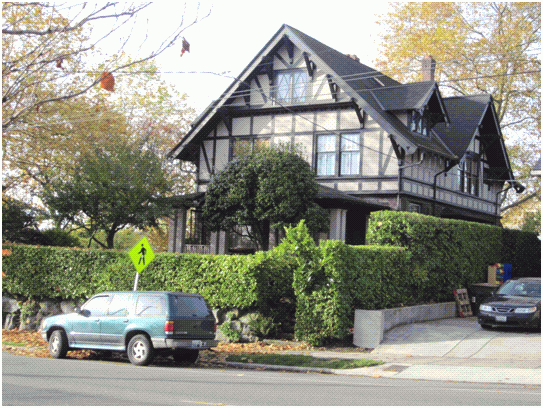
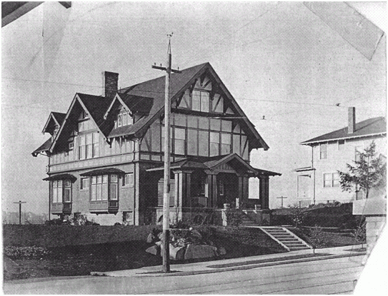
Attachments |
|---|
![[TOP]](/netaicon/toppg.gif)