WHEREAS, the Burke-Gilman Trail currently links Bothell, Kenmore, the University of Washington and several Seattle neighborhoods with a current terminus at 11th Avenue NW; and
WHEREAS, the Burke-Gilman Trail serves much of north Seattle and the Puget Sound Region as a successful, scenic and safe non-motorized transportation, recreation and community facility; and
WHEREAS, the citizens of Ballard identified the completion of the Burke-Gilman Trail through Ballard as one of four top priorities in the 1998 Crown Hill Ballard Neighborhood Plan; and
WHEREAS, the City has a strong planning framework and policy commitment, as demonstrated by its comprehensive plan and strategic transportation plan, that guide and encourage expanded facilities and safety improvements for citizens who walk, bicycle or
use other nonmotorized forms of travel, recognizing that freight mobility is critical to the City's economic base; and
WHEREAS, the Ballard Interbay Northend Manufacturing/Industrial Center has been identified and designated as one of two areas where the City will promote manufacturing and industrial employment growth including manufacturing uses, advanced technology
industries and a wide range of industrial-related commercial functions, such as warehouse and distribution activities; and
WHEREAS, the Ballard Interbay Northend Manufacturing/Industrial Center contributes to Seattle's diversified employment base and to the growth of high-wage jobs within the Central Puget Sound region; and
WHEREAS, maintaining freight mobility and freight access is a high priority in the City's Transportation Strategic Plan and the City's Comprehensive Plan and it is critical that the City work to preserve freight mobility and access in the industrial
areas; and
WHEREAS, protecting the integrity of those areas of the City that are zoned for industrial activity, particularly the Ballard Interbay Northend Manufacturing/Industrial Center and other industrial zones that host water dependent marine industrial
activities, is identified as an important policy objective in Seattle's Comprehensive Plan; and
WHEREAS, Resolution 30408, adopted in October, 2001, directed Seattle Transportation to evaluate "three bicycle/pedestrian routes to complete the Burke-Gilman Trail between 11th Avenue NW and the Locks;...work closely with business and property owners,
trail advocacy groups and community groups;...determine where acquisition of land may be necessary;...(and) prepare a final report summarizing its analysis of alternative routes;" NOW, THEREFORE,
BE IT RESOLVED BY THE CITY COUNCIL OF THE CITY OF SEATTLE, THE MAYOR CONCURRING, THAT:
Section 1. The City reiterates its commitment to the following guiding principles that have guided trail development for the past fifteen years:
A. The first priority when building transportation facilities is always safety.
B. Safe and efficient customer and freight access to businesses must be maintained.
Section 2. The rail corridor between 11th Avenue NW and the Ballard Locks is already in public ownership. Consistent with current City policy, the City should continue preservation of the corridor, in public ownership, for rail and trail use.
Section 3. Consistent with adopted City policies and plans, the preferred route (both interim route and permanent routes described in Section 4 below) for the Burke-Gilman Trail from 11th Avenue NW to the Ballard Locks will be designed to address
safety concerns and to be compatible with water-dependent and industrial uses, particularly in the Ballard Interbay North End Manufacturing/Industrial Center, and to ensure that the trail does not unnecessarily impede or delay trucking and freight
access to manufacturing and industrial businesses. Examples of possible safety measures include pavement markings; regulatory, warning and wayfinding signs; pedestrian/bicycle signals; mechanical gates; mirrors; elevated crossings; etc.
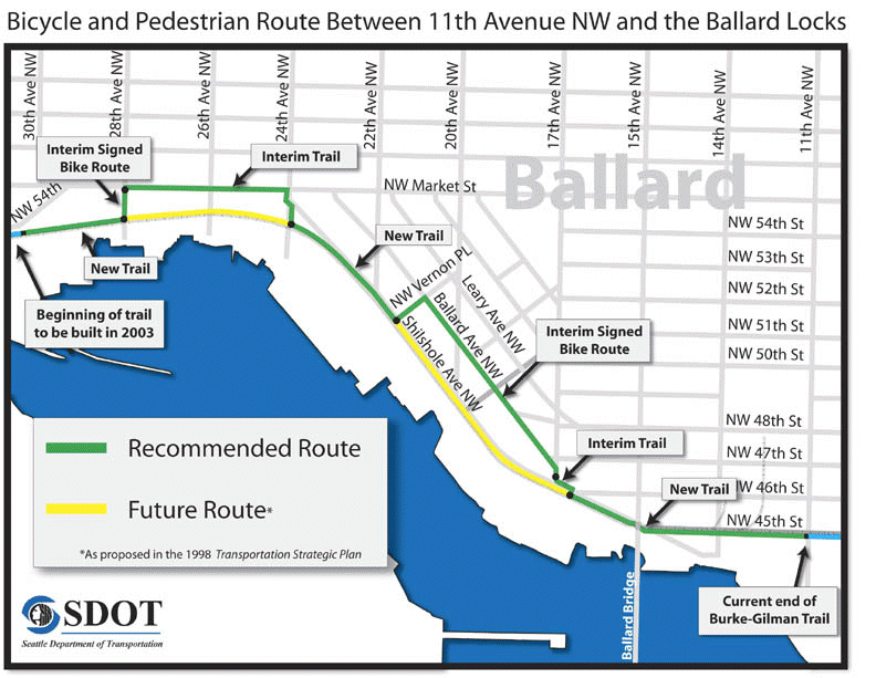
Section 4. The preferred route for the Burke-Gilman Trail "missing link" between 11th Avenue NW and the Ballard Locks, as described below and as shown on the map attached as Exhibit A (once final design is completed, some small modifications may be
required; these modifications to be left to the discretion of the City Traffic Engineer for approval), is hereby adopted and SDOT will design and construct the preferred route as follows:
A. Design and construct the following permanent route:
1. On the south side of NW 45th Street, from 11th Avenue NW (the current terminus of the Burke-Gilman Trail) to Shilshole Avenue NW construct a trail.
2. On the south side of Shilshole Avenue NW (north side of tracks) between NW Vernon Place and 24th Avenue NW, construct a trail.
3. On the north side of the railroad tracks from 28th Avenue NW to 30th Avenue NW (the Locks), construct a trail.
B. Design and construct an interim route as follows:
1. On Shilshole Avenue NW from NW 45th Street to 17th Avenue NW, construct an interim trail or install bike lanes.
2. On 17th Avenue NW from Shilshole Avenue NW to Ballard Avenue NW, install a signed bike route.
3. On Ballard Ave NW from 17th Avenue NW to NW Vernon Place, install a signed bike route.
4. On Vernon Place between Ballard Avenue NW and Shilshole Avenue NW, install a signed bike route.
5. On 24th Avenue NW from the rail corridor to NW Market Street, construct an interim trail.
6. On NW Market Street from 24th Avenue NW to 28th Avenue NW, construct an interim trail that can be used later as a sidewalk.
7. On 28th Avenue NW from NW Market Street to the rail corridor, install a signed bike route.
C. Subject to the conditions in Section 3, design and construct a permanent route to replace the interim route as follows:
1. On Shilshole Avenue NW, from NW 45th Street to NW Vernon Place, construct a bicycle and pedestrian facility.
2. On the railroad right-of-way, from 24th Avenue NW to 28th Avenue NW, construct a trail.
Section 5. Seattle Transportation, in cooperation with other appropriate City departments, including the Department of Finance, will seek funding (e.g. federal grants and other sources that may be available) for the following:
A. The design and construction of the trail as described above.
B. The purchase, for public use, of a narrow strip of property (its exact width to be determined) on the north side of the railroad tracks, west of 26th Avenue NW; and other smaller pieces of property, as required, to complete the design and
construction of the trail. Once the right-of-way between 26th Avenue NW and 28th Avenue NW has been secured, Seattle Transportation will determine whether it is appropriate to construct a trail along this section; and then decommission all or part of
the interim route along NW Market Street.
Section 6. In locations where private redevelopment or public works projects are being considered near the rail corridor, Seattle Transportation and other appropriate City departments will work with property owners to resolve design challenges and make
safety improvements for all modes, so as to accommodate a future trail described in Section 4C above.
Section 7. Beginning immediately and continuing for two years subsequent to operation of the new segment of trail, SDOT shall monitor auto, bike and pedestrian accident data, and trail use along the length of Burke Gilman Trail from the intersection of
N.W. 45th Street and 11th Avenue N.W. to where the trail meets the Ballard Locks. SDOT shall monitor bike and pedestrian use prior to construction to generate baseline data, and post construction to determine if the public is utilizing the new "interim"
sections of trail as intended, or if riders are deviating from the trail to follow the Shilshole Avenue and "Not 54th Street" corridor. In particular, SDOT shall monitor trail use at the intersection of Shilshole Avenue N.W. and 17th Avenue N.W., the
intersection of Ballard Avenue N.W. and N.W. Vernon Place, and the intersection of Shilshole Avenue N.W. and 24th Avenue N.W. SDOT shall develop a monitoring methodology that provides data that is representative of bike and pedestrian use at different
times of day throughout the year. SDOT shall report back to the Council on its findings periodically, and at the conclusion of the two year monitoring period shall provide Council with a report and recommendations for any modifications to the interim
and permanent trail routes that may be called for to encourage usage along the designated path.
Section 8. The Seattle Transportation "Ballard Corridor Design Study (11th Avenue NW to the Locks)" February, 2003, fulfills the requirements of Resolution 30408 to complete an analysis of three alternative routes for completing the Burke-Gilman Trail
between 11th Avenue NW and the Locks.
Section 9. The City will continue to support manufacturing and industrial businesses in the area, including working with the Manufacturing Industrial Council and the Ballard Interbay Northend Manufacturing/Industrial Center members to develop and
implement initiatives to meet the needs for freight mobility, trained workforce and land use of Seattle's industrial business community, and to assist the maritime industry in completion of an economic analysis and action plan for the maritime industry
in response to a 2003 Budget Statement of Legislative Intent adopted by Council (Resolution 30576).
Section 10. The Council believes that the current Industrial zoning of the Ballard Interbay Northend Manufacturing/Industrial Center should remain unchanged. The City will continue to support manufacturing and industrial businesses across the City and
will work collaboratively with representatives of industry to insure that there will always be sufficient zoning to meet the needs of the Seattle's industrial manufacturing sectors, particularly water dependent marine industrial enterprises.
Adopted by the City Council the ____ day of _________, 2003, and signed by me in open session in authentication of its adoption this _____ day of __________, 2003. _________________________________ President __________of the City Council
THE MAYOR CONCURRING: _________________________________ Gregory J. Nickels, Mayor
Filed by me this ____ day of _________, 2003. ____________________________________ City Clerk
Exhibit A: Map of the plan for completing the Burke-Gilman Trail "missing link" between 11th Avenue NW and the Locks
April 14, 2003 Version 5
Exhibit A: Map of the plan for completing the Burke-Gilman Trail "missing link" between 11th Avenue NW and the Locks ta
![[HOME]](/netaicon/homeicon.gif)
![[SEARCH]](/netaicon/srchpage.gif)

![[CURR_LIST]](/netaicon/curlist.gif)


![[NEXT_DOC]](/netaicon/nxtdoc.gif)
![[LAST_DOC]](/netaicon/lastdoc.gif)
![[BOTTOM]](/netaicon/bottom.gif)
![[HELP]](/netaicon/help.gif)
![[TOP]](/netaicon/toppg.gif)