![[HOME]](/netaicon/homeicon.gif)
![[SEARCH]](/netaicon/srchpage.gif)

![[CURR_LIST]](/netaicon/curlist.gif)


![[BOTTOM]](/netaicon/bottom.gif)
![[HELP]](/netaicon/help.gif)
Seattle City Council Resolutions
Information modified on June 18, 2002; retrieved on April 25, 2025 3:24 PM
Resolution 30479
Title | |
|---|---|
| A RESOLUTION relating to Seattle Public Utilities, authorizing application to the Washington State Department of Natural Resources for funding assistance for an Aquatic Lands Enhancement Account (ALEA) project involving the acquisition of certain shoreline properties downstream of the Ballard Locks. | |
Description and Background | |
|---|---|
| Current Status: | Adopted |
| Index Terms: | GRANTS, WASHINGTON-STATE, SEATTLE-PUBLIC-UTILITIES, BALLARD, FISH, ENVIRONMENTAL-PROTECTION, CHITTENDEN-LOCKS, LAND-ACQUISITION, SALMON-BAY |
Legislative History | |
|---|---|
| Sponsor: | PAGELER |
| Date Introduced: | May 28, 2002 |
| Committee Referral: | Water and Health |
| City Council Action Date: | June 10, 2002 |
| City Council Action: | Adopted |
| City Council Vote: | 9-0 |
| Date Delivered to Mayor: | June 11, 2002 |
| Date Filed with Clerk: | June 13, 2002 |
Text | |
|---|---|
|
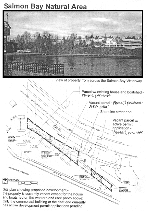
WHEREAS, under the provisions of Chapter 79.24.580, RCW, state funding assistance has been authorized and made available to aid in financing the cost of land and the construction of facilities for public access to, and enhancement of, aquatic lands; and WHEREAS, the City Council of Seattle, Washington considers it in the best public interest for the City of Seattle to acquire three parcels of shoreline land in the Salmon Bay Waterway, generally located in Ballard adjacent to the 34th Avenue NW street end immediately downstream of the Hiram M. Chittenden Locks; NOW, THEREFORE, BE IT RESOLVED BY THE CITY COUNCIL OF THE CITY OF SEATTLE, THE MAYOR CONCURRING, THAT: 1. Seattle Public Utilities is authorized to make formal application to the Department of Natural Resources for funding assistance for an Aquatic Lands Enhancement Account (ALEA) project involving the acquisition of certain shoreline properties downstream of the Ballard Locks identified in Attachment A. 2. Any fund assistance so received is to be used in the acquisition of the parcels identified in Attachment A, and the development of public access areas and interpretive signs, all subject to Council approval by Ordinance. 3. The city's 50% matching share for the project consists of funds appropriated in the Seattle Public Utilities capital improvement budget as approved by the Seattle City Council in a 2001/2002 City Council Budget Action, and funds committed by other third parties identified in Attachment B. 4. Any property acquired with financial aid through the Aquatic Lands Enhancement Account will be required to be maintained for the purpose of habitat protection and/or public access in perpetuity and in accordance with the terms of a grant agreement to be approved by the Department of Natural Resources. 5. Any developed facilities financed through the Aquatic Lands Enhancement Account will be required to be maintained by the city for 25 years or longer. 6. This resolution will become part of a formal application to the Department of Natural Resources, included in Attachment C. 7. Adequate notification has been given, including an opportunity provided for public input. Adopted by the City Council the _____, day _____, 2002, and signed by me in open session in authentication of its adoption this _____ day of _______________, 2002. ________________________________________ President of the City Council THE MAYOR CONCURRING: ________________________________________ Mayor Filed by me this _____ day of _______________, 2002. ________________________________________ City Clerk 06/07/02 Version # 2 t ATTACHMENT A ATTACHMENT B Funds Committed by the City of Seattle and Third Parties City of Seattle (appropriation) $335,000 Private Donations $70,000 (pledges) Neighborhood Matching Fund Grant from $150,000 Seattle Department of Neighborhoods King Conservation District Grant $50,000 National Fish and Wildlife Foundation Grant $150,000 t ATTACHMENT C ALEA 2002 Grant Application Booklet 21 Appendix A Project Evaluation Questionnaire Complete and mail with application Must be received by June 1, 2002 PROJECT SPONSOR: Seattle Public Utilities on behalf of the City of Seattle PROJECT NAME: Salmon Bay Natural Area SITE LOCATION (required): Section/township/range PROJECT TYPE: (circle one) Acquisition Restoration Public Access Combination AP RP PA Combo Answer each question below that is marked for the type of project (AP, RP, PA) you indicated above. Combination projects must answer all questions. If a question is not marked for a specific project type, you must answer that question also. Refer to the info in this booklet including the Project Evaluation criteria and scoring guidelines for guidance in answering the questions. 1. Project Type and Purpose A. Explain how this project will protect and/or restore habitat functions and values at the site. (AP/RP projects) The Salmon Bay Natural Area project will protect and enhance the last substantially undeveloped, wooded shoreline on Seattle's Salmon Bay Waterway, the estuary for the Greater Lake Washington Watershed. Seattle Public Utilities (SPU) on behalf of the City of Seattle (City) plans to acquire five shoreline parcels in two phases (see Figure 1). In the fall of 2002, SPU will partner with the Ballard-based community group Groundswell NW and the regional nonprofit Cascade Land Conservancy to purchase four of the five parcels. SPU's request to the Aquatic Lands Enhancement Account Program is for funding to support acquisition of the final parcel, and for design and construction of public access facilities and interpretive signage.1 The five adjacent parcels total 1/3 of an acre, and 414 feet of shoreline. Adjacent to these parcels are a city owned street end and state owned tidelands. Together with this publicly owned land, the Salmon Bay Natural Area provides 700 feet of shoreline habitat. The Salmon Bay Natural Area project is the best opportunity currently available to protect and improve habitat for migrating salmon in the Salmon Bay estuary. Ongoing studies show that juvenile chinook and other salmon species use this shoreline waterway extensively for refuge and rearing. The high salmon usage at the site led the WRIA 8 Steering Committee, to rank this project as the highest priority for salmon habitat restoration funding in 2002. Acquisition by the city, in partnership with the ALEA program, will protect an area with remarkably high habitat values from the impacts of development and allow for restoration/enhancement of the site. The Army Corps of Engineers has expressed a strong interest in helping to fund a removal of over-water structures, restoration of inter-tidal and tidal substrates where needed, and enhancement of native vegetation along the bank. Once fully protected and restored, the Salmon Bay Natural Area would be a showcase for urban habitat restoration. B. Explain how this project will provide or improve public access to the water. (PA projects) n/a C. How will this project enhance the public's understanding and enjoyment of aquatic resources? The project will provide public access to shoreline property in a developed area where few opportunities exist to see the water. It will also allow the public to learn about the importance of restoring habitat for salmon and other aquatic resources even in the most urbanized areas. The site is located in the heart of Ballard, a north end Seattle neighborhood (see Figure 2). It is a short walk from the Hiram M. Chittenden Locks (Locks), a tourist attraction that draws over 1.5 million visitors each year. The site's location creates a unique opportunity to give public visibility to habitat restoration efforts in urban environments. An interpretive area with benches will offer visitors a pleasant view of the Salmon Bay estuary, and an opportunity to see first hand how habitat restoration can be accomplished in such a setting. Through interpretative signs, site visitors may learn about: * the importance of estuarine environments to salmon migration; * the role of Seattle and other jurisdictions in recovering salmon habitat in estuary and near shore environments; * the sources of funding, particularly public funding, that have made the project possible, and * what has been done to improve habitat at the Salmon Bay Natural Area. This project will also provide direct opportunities through community-organized work parties for the public to get directly involved in hands-on habitat restoration, further increasing their understanding of, and support for salmon recovery. 2. Need and Public Awareness A. What is the need for this project and how is it evidenced (studies, surveys, or other analysis)? Describe the cost/benefit analysis done for this project. The Salmon Bay Natural Area project is located on the north side of the Salmon Bay Waterway, directly downstream of the Locks. Studies by the City of Seattle, the Army Corps of Engineers, and the University of Washington School of Fisheries have provided evidence that the Salmon Bay Natural Area is in a critical habitat area for several species of salmonids, including chinook, pink, and chum. Purse-seining efforts by the Washington State Department of Fish and Wildlife between 1997 and 2001 found large numbers of juvenile salmonids immediately upstream of the Salmon Bay Natural Area. These salmonids included juvenile chinook from WRIA 8, as well as pink and chum juveniles swimming into the area from other watersheds. It is believed that the intensive use of the area results from the availability of large quantities of food (freshwater zooplankton) and the relative protection from high-energy flows created by the Army Corps of Engineers' wing wall pier south of the site. The University of Washington's Wetland Ecosystem Team has gathered data at the project site. In a recent talk at the Estuarine Research Society's (PERS) 2002 meeting, the team presented preliminary findings on salmon usage in nine sites in the Salmon Bay Waterway and adjacent near shore (see Figure 3.) Based on weekly rankings of "catch per unit effort" from May through July, the team gave the Salmon Bay Natural Area the highest ranking among those nine sites. Finally, juvenile salmon migration studies at the Ballard Locks have demonstrated that between 3 million and 15 million salmon smolts migrate through the Ship Canal and into Salmon Bay. If only 10% of this number use the north side of the channel along which the property is located (a conservative estimate), that would be between 300,000 and 1,500,000 smolts annually. In a low water year this percentage would be much higher as a result of the limited deployment of smolt flumes on the south side of the Locks. The scarcity of undeveloped land in the lower Greater Lake Washington watershed makes the value of protecting this site from further development almost incalculable. There are no other sites along the Salmon Bay Waterway that exhibit its habitat features largely intact wooded riparian areas, shallow slopes and fine substrates. The high salmon use already measured at the site is a clear indication of its long-term value for salmon and other aquatic species. The opportunity to protect and restore its habitat in perpetuity is very precious. Undeveloped land in Seattle is more expensive on a cost-per-acre basis than undeveloped land in rural areas. Thus the cost of acquiring the five parcels constituting the Salmon Bay Natural Area is substantial. However, the site is used by hundreds of thousands of smolts per year, the actual cost of acquisition per smolt, measured over decades, is quite reasonable. B. Is the site located in an ecologically critical area of the estuary or basin that is important for certain species? (AP/RP projects) The position of the Salmon Bay Natural Area within the Greater Lake Washington Watershed makes it an area of particular ecological significance for salmon (see Figure 4). The property begins only 115 meters below the locks, in a small area that has been termed the "neoestuary." This location is within a critical transition zone for many species of salmonid smolts migrating from the fresh water environments of the watershed into Puget Sound. Smolts need areas of intermediate salinity typically found in estuaries to adjust physiologically to marine conditions. The existence of the M. Chittenden Locks creates a far more abrupt transition between fresh and salt water than is found in natural estuaries. However, a small transition zone is located immediately below the Locks, in the vicinity of the Salmon Bay Natural Area. In addition, the location of the site ensures an excellent source of food not only for juveniles from the Greater Lake Washington Watershed, but also for juveniles from other watersheds that are migrating along the marine near shore. Large quantities of zooplankton (Daphnia) from Lakes Washington and Union are transported through the Ballard Locks to the site. When the freshwater zooplankton arrive in salty tidal waters, they become physiologically stressed and extraordinarily vulnerable to predation. This phenomenon is believed to partially explain the observed heavy use of the area for salmon feeding and rearing. C. How has the public been made aware of this project? Is it identified in an approved watershed plan or local plan? Multiple partners have come together in the effort to raise funds for the acquisition and ultimate restoration of the Salmon Bay Natural Area, including the City of Seattle, the Ballard-based group Groundswell NW, and the Cascade Land Conservancy. Each of these groups has created opportunities for public input into the project. Groundswell NW, a dedicated and highly motivated group of Ballard residents initiated this project through a neighborhood planning process involving many residents. They dedicated nearly 3 years to raise enough funds for acquisition of the majority of the parcels, including funds from the City of Seattle. During this period, they have informed and sough input on the project from a variety of community groups including the Seaview Neighbors Association, the Sunset Hill Community Council and the Ballard District Council. They have held a community design workshop to get input and discuss ideas for a conceptual plan for the site. Articles about our efforts to preserve the property have appeared in the Ballard News-Tribune, the Queen Anne-Magnolia News and 4 issues of the Groundswell NW newsletter (current distribution: 500). The project has been recommended in "Near Term Action Agenda" for the Greater Lake Washington Watershed (WRIA 8). The City of Seattle is working with other watershed jurisdictions, King County, environmental groups and businesses in a long-term effort to develop a comprehensive watershed salmon conservation plan. The first planning product developed in this collaborative process was the Near Term Action Agenda (NTAA), a document that describes positive steps local jurisdictions and other entities can take to protect salmon while the larger plan is still being developed. The Salmon Bay Natural Area project was recommended for acquisition in the NTAA. The complete NTAA was presented at four public open houses around the watershed. Comments from the public are being incorporated now, and the final document will be approved by the WRIA 8 Steering Committee this summer. Finally, the City of Seattle has informed the public and sought its feedback as part of a larger public involvement process to gather feedback on its Urban Blueprint for Salmon Habitat Protection and Restoration, a scientific assessment of chinook habitat needs within the City. The Salmon Bay Natural Area is listed as a potential habitat restoration project in the Blueprint. Numerous community meetings were conducted to present the Blueprint and gather feedback, including meetings with each of Seattle's 13 neighborhood district councils. D. Define the public served by this project. Describe the public's response to this project, including any concerns. As indicated previously, the site is a short walking distance from the M. Chittenden Locks, a tourist attraction that draws over 1.5 million visitors each year. With the publicity surrounding the project, many people are expected to include this site in their Locks visits. In addition to informal visits, Groundwell NW plans to bring groups to the area for talks and tours. Specific groups that may visit include: * Residents of the Ballard and Magnolia neighborhoods; * Students from Ballard High School; * Students from other K-12 schools in the neighborhood, including Adams Elementary, Loyal Heights Elementary etc.; * The customers of Hiram's restaurant a popular full-service restaurant adjacent to the site In a general sense, the public served by this project includes all people who care about salmon recovery in the Greater Lake Washington watershed (see Figure 4). This includes people who will likely never visit the site, but who believe that jurisdictions and citizens should work together to restore high quality salmon habitat. The public response to the project has been overwhelmingly positive as demonstrated in endorsements and active involvement in the project by neighbors, community groups, and organizations and agencies involved in watershed conservation. 3. Physical Suitability of the Site and Appropriateness of Use A. Describe the current use of the site and history. Include past human uses and prior habitat functions. Are there any water control structures affecting the site (eg: culverts, tide gates, outlets, etc.)? Are there any exotic species that may affect the success of the project? The parcels that constitute the Salmon Bay Natural Area project site are under a single ownership. Figure 1 shows the configuration and features of these parcels. Parcels 1176001360 and 0467000815 are vacant. Parcels 1176001388, 0467000555 and 0467000875 have a small 1920s-era house, as well as a boat shed and small boat dock. It has been reported that the site was used seasonally by local tribes for fishing and shellfish digging. Additional research needs to be done on the use of this area by native tribes. Results of the research may become a rich source of material for the interpretive displays planned for the site. The Army Corps of Engineers maintains a finger pier/guidewall extending from the Locks. By partially separating the site's tidelands from higher velocity flows in the center of the channel the finger pier provides important shelter for smolts. The construction of the Locks and Salmon Bay Waterway altered flows and salinities in the estuary, while shoreline modifications and intensive development along the Salmon Bay Waterway have drastically altered the original shoreline habitat for salmon and other aquatic life. As a result, the protection and restoration of high quality habitat in this area is critical to the long-term sustainability of aquatic species life. While there are some invasive plants on site, Groundswell NW has successfully removed blackberries and ivy from the street end. The group will continue to remove blackberry and ivy with monthly work parties starting June 2, 2002. B. Does the project have functional connectivity with existing or potential habitat sites (eg: contiguous to other high value habitats; can become part of an existing or potential wildlife corridor)? What are the threatened and endangered aquatic species associated with the site? (AP/PR projects) The two most prominent threatened aquatic species associated with the site are chinook salmon and bull trout. Both juvenile and adult chinook salmon use the inner Salmon Bay neo-estuary, as well as adult bull trout. The site is also extensively used by other salmonids, including chum, coho, pink, steelhead and cutthroat. The project will provide juvenile salmon outmigrating to Puget Sound with refuge, rearing and feeding areas, and a transition area to salt water Although much of the northern shoreline in the Salmon Bay Waterway is developed, there are several opportunities to create connectivity with other existing or potential high-value habitats, offering important opportunities to enhance wildlife populations in the City of Seattle. These opportunities are listed below: 1. Discussions have begun about potential Commodore Park restoration across the waterway, which would complement protection and restoration efforts at Salmon Bay Natural Area. 2. Groundswell NW and other neighborhood and environmental groups in the City are working to create a Marine Protected Area around Golden Gardens and Carkeek Parks. This status could help ensure that Salmon Bay Natural Area is near other high value salmon habitat for juvenile and adult salmon. 3. In the Kiwanis Ravine, south of the channel, there is an urban creek and a healthy heron rookery. Neighborhood residents are developing a plan to protect and improve the high-value bird habitat into the future. Salmon Bay Natural Area is located along the flyway between Discovery Park and the rookery to the south, and the Sunset Hill Greenbelt, Golden Gardens and Carkeek Parks to the north. 4. In addition, the city is currently investigating the possibility of daylighting some or all of Kiwanis Creek, which currently enters the estuary in a pipe. A daylighting project could result in the further enhancement of salmon habitat downstream of the Locks. 5. There are plans to extend the Burke Gilman Trail from the Locks to Golden Gardens, past Salmon Bay Natural Area, in 2002. This urban greenbelt contains a paved path for human use, but also includes vegetated buffers on either side of the paved area that create habitat for terrestrial species and birds. A number of small shoreline street end parks have been built or are being planned to include viewpoints as well as habitat. C. Is the site large enough to maintain long-term ecosystem function on its own, or is it adjacent to a large protected area or areas that will complement existing habitat? (AP/RP projects) Wild salmon runs from the Cedar and Sammamish rivers swim through the Locks and by this site every year, along with many other aquatic species. Currently, there are some natural processes taking place at the site that help to create refuge and rearing habitat. These include recruitment of organic debris (including wood), recruitment of fine particle substrate preferred by chinook, and production of terrestrial and aquatic food. As restoration takes place in the intertidal area and along the banks, these natural processes will be reinforced. With targeted restoration complete, the site should maintain high quality habitat for salmonids with minimal human intervention. E. Describe the natural features of this site that make it a suitable location for this project, such as wave exposure, shoreline processes, bank height, view, slope, habitat, etc. The proposed acquisition includes 5 adjacent parcels totaling 1/3 of an acre and 414 feet of shoreline. In addition to these parcels, there is an adjacent street end owned by the City of Seattle, and restoration work has already begun at this site. Together with this street end and adjacent State-owned land, the property would provide 700 feet of public shoreline habitat. Many of the site's natural features make it suitable for salmon habitat restoration. These include: 1. Shallow slope The slope of the property extends into the water about 50 feet, with an average slope of less than 10%. Research by Roger Tabor of the U.S. fish and Wildlife Service in Lake Washington, Lake Union and the Ship Canal indicates that juvenile chinook salmon show a strong preference for shallow aquatic areas with gradual slopes (<20%). 2. Fine Substrates The site's intertidal area and tidelands exhibit fine substrates similar to those shown by Brian Footen of the Muckleshoot tribe to be favored by juvenile salmon in Shilshole Bay 3. Wooded hillside with significant potential for native vegetation growth The project site is the last undeveloped wooded site within the tidal system and has a significant stand of mature trees. These trees can become a source of woody debris in the channel. In addition, once invasives such as blackberry are replaced with native vegetation, the hillside will be a rich source of food for juvenile salmon. 4. Protection from high velocity currents immediately below the Locks The aquatic part of the site also displays substantially lower current velocities than those found along the opposing southern shoreline, and a number of fish biologists believe that this, along with the high concentrations of zooplankton in the water helps to explain the sites heavy usage by juvenile salmon. F. Is the site sufficiently separated from sources of contaminants or environmental disturbances (eg: contaminated sediments, pollution, noise, or light) so as not to cause a long term problem for fish and wildlife or public use? Terrestrial Contamination or Disturbance There are no known sources of contamination on or adjacent to the site. The property owners hired GEOTECH to conduct a Phase One Environmental Site Assessment in 1997. Seattle Public Utilities' Senior Real Estate Manager reviewed this assessment in 2002. It raised no major issues of concern, and no Phase Two Environmental Site Assessment is needed. In addition to the Phase One Environmental Site Assessment, Seattle Public Utilities' Real Estate Manager has researched prior uses of the property lots to determine whether any of these uses might suggest the possibility of site contamination. Specific uses of concern would have included, for example, a marina or gas docks. No such uses were discovered. The only known potential source of disturbance is vehicular traffic on a roadway which is substantially set back from the tidelands and vegetated bank. Aquatic Contamination or Disturbance The low level of industrial land use in the Salmon Bay estuary and the velocity of currents downstream of the Locks combine to make it unlikely that sediments in the vicinity contain any substantial contamination. Moreover, the Locks act as a barrier to the downstream migration of any potential contaminated sediments from upstream. Water quality in this area is thought to be relatively good. Efforts over the last thirty years to clean up Lake Washington have substantially reduced the amount of pollution carried from the Lake into the Ship Canal and the Salmon Bay estuary. G. What steps have been taken to avoid or mitigate adverse impacts to sensitive areas? Restoration efforts to date have focused on removing invasives such as blackberries on the publicly-owned uplands, with precautions to ensure that plant removal does not result in run-off that could cause erosion on the steep banks of the property. Groundswell NW has begun experimenting with non-toxic methods for controlling the blackberries on the steep slopes without removing the root structure or exposing bare earth, and is developing plans for live-staking to introduce native overhanging vegetation above the waterline without disturbing the soil. 5. Site Monitoring and Management A. Describe the monitoring requirements for successful restoration. (RP projects) No grant funding from the ALEA program is requested for restoration work at this site. However, future restoration plans are being developed: Portions of the Salmon Bay Natural Area are in need of restoration/enhancement. For example, over water structures are targeted for demolition significantly increasing the refuge opportunities presented by the site. Restoration will include removal of invasive plants and planting of native species throughout the bank. Finally, restoration actions will include removal of rip rap and cement blocks scattered on the tidelands, materials chinook salmon actively avoid in Lake Washington and the Ship Canal. A partnership for completing these restoration actions will be developed with the Army Corps of Engineers as part of the implementation of the Lake Washington/Ship Canal General Investigation Study and Project. B. What indicators will be used for monitoring the project? (RP projects) n/a C. What baseline date is available for the project site and what is the source? (AP/RP projects) Monitoring at this site began in April, 2001 as part of the U.S. Army Corps of Engineers Lake Washington/Ship Canal General Investigation (LWSC GI). Monitoring of juvenile salmon abundance is being conducted by beach seining and snorkeling surveys. Initial investigations show that the area along this shoreline is heavily used for refuge by salmon smolts, not only from the Greater Lake Washington Basin, but by juvenile species (like chum, pink, chinook, and coho salmon) accessing the area from Puget Sound. Monitoring will continue in 2002 and 2003. Three years of monitoring data will create a sound baseline for measuring changes in salmon usage over time D. What arrangements have been or will be made to monitor the site for the life of the project? Is there a monitoring plan for the site? (RP projects) n/a E. What will be done if the monitoring results do not show success for the site? (RP projects) n/a F. How will the site be staffed and managed to protect the site from vandalism, and to ensure public safety and compliance with existing laws? The site is visible from the road, and can be easily observed by the Seattle Police Department. Prior to the initiation of restoration work, the city will maintain a caretaker in the rental house. Seattle Public Utilities (SPU) and Seattle's Department of Parks and Recreation will collaborate on the development of a management and maintenance plan for the site. This plan will become operational when the properties enter public ownership. This could be as early as summer 2002 for the four parcels part of the Phase 1 purchase. The Parks Department will have lead responsibility for on-going site management and maintenance. Trained Parks maintenance crews will periodically empty trash receptacles at the visitor viewing area. Groundswell Northwest is also committed to help maintain the site through on-going work parties and Adopt-a-Park type agreements. G. Is there a potential for user conflicts at the site? (PA projects) n/a H. What are the long-term arrangements for maintenance of the site? (PA projects) n/a 6. Quality of Design A. Will the project require decreasing involvement over time? Attributes impacting the likelihood of success include elevation, water level, currents, deposition, wave energy, topography, bathymetry, and shoreline condition. (AP/RP projects) Yes. As part of restoration work planned for the site, invasive plants growing in the banks will be removed and replaced with native vegetation. As this vegetation matures, less time and effort will be needed to maintain the habitat values of the shoreline. In addition, removal of the overwater structures will involve a short-term investment that will require no on-going maintenance, but will offer significant habitat enhancements. B. How will timing of the restoration effort minimize impacts on fish and wildlife? Will activities such as vegetative planting or instream work occur at the most viable times? (RP projects) n/a C. What is the nature and condition of existing surrounding land use as well as future concerns such as shoreline designation, zoning, comprehensive or project-specific planning? * The project site is adjacent to public land (a rail-banked ROW owned by the city and operated by a franchise short-line rail company) and a shoreline street end * The east end of the property abuts a restaurant site with a steep bank that has been routinely cleared of vegetation. Groundswell NW is currently working with the owners of the restaurant to develop a joint maintenace plan that will include this bank in the restoration area. * The west end of the property abuts the Burlington Northern/Santa Fe ROW and their Ship Canal bridge. Immediately west of the bridge are several small, older over-water houses and boat sheds with associated dock and floats. The current owners of the Salmon Bay Natural Area are retired and wish to sell the property. A change in ownership places an immediate threat of conversion to more intensive development on any under-developed property. According to staff at Seattle Department of Construction and Land Use: the property can be legally developed. It is zoned Commercial with a 30 to 40 foot height limit. In addition, city code allows certain commercial uses to be permitted over water as "Shoreline Conditional Uses" on lots with less than 50 feet of dry land. Due to the costs associated with permits, future owners will likely be forced to achieve the absolute maximum building footprint on the site, and may even attempt to obtain over-water permits. If the five parcels were purchased and developed, many of the features that currently create good habitat or potential habitat for salmon would likely be lost as a result of the construction of over water structures, shoreline-hardening, impervious surface areas, and removal of the bay's last stand of mature trees. Development would also likely preclude future restoration activities. We are currently negotiating a phased acquisition, with an initial purchase of four parcels this fall and an option to purchase the final parcel when funding is available. Funding from this grant would complete the entire acquisition. The owners are amenable to this structure in concept, and are currently reviewing a purchase offer. D. How is the site design visually integrated into the landscape features? (PA projects) n/a E. How will the site be designed to handle projected use? (PA projects) n/a F. How viable are the proposed public use facilities, given the required regulatory and proprietary approvals, funding, etc.? (PA projects) n/a 6. Quality of Interpretation A. Describe the content of the interpretive elements of the project. The interpretive plan for the Salmon Bay Natural Area consists of four major elements: Planned site improvements A viewing area will create a place for the public to gather and enjoy views of the Salmon Bay Waterway, the site's riparian wooded areas, the Locks, the railroad bridge, and Commodore and Discovery parks across the Bay. Two paths will provide access points from the sidewalk and from an informal viewing area west of Hiram's Restaurant's outdoor dining. A sculpture celebrating the cultural history of the site or its natural resources will be designed and installed. Figure 5 shows a preliminary concept plan developed by J.A. Brennan Associates, PLLC. On-site interpretive signage Signs will be installed following the acquisition. They will detail the unique natural and cultural history of the site, highlighting the importance of the area for salmon use, the historical alterations of the estuary, and historic Native American use of the area. Signs will also highlight participating funders. Guided tours Scheduled tours of the site will be offered to the numerous schools, community groups, and other interested parties in northwest Seattle. School tours will be integrated into Seattle school district curriculum on salmon life cycles. Self-guided tours A brochure will be designed, reproduced, and stocked at the Locks and Hiram's Restaurant to facilitate a brief self-guided walk. The walk will include the Locks, the Salmon Bay Natural Area, a future restoration site currently under consideration at Commodore Park, and other points of interest. B. Methods, Materials, and Responsibilities Initial concept designs for site improvements and interpretive elements have been developed. The immediate viewing area will be approximately 12' x 12' with a crushed rock surface and a wood post and railing system with wire mesh filling the voids, which is a mostly transparent material. The overall viewpoint is approximately 30' x 30' (900 sq. ft.). The path traversing the top of the slope will be approximately 3 to 4 feet wide, and will be constructed of mulch or crushed rock. Interpretive signage will be composed of enamel signs on steel backing mounted on steel posts. The City of Seattle and Groundswell NW will collaborate on the content and the city will produce the signs. Tours will be offered by appointment by Groundswell NW and will be hosted by Groundswell staff and volunteers. The brochure supporting the selfguided tours will be written by the city and Groundswell NW, designed and reproduced by the City, and distributed by Groundswell NW. Design of site improvements will be undertaken by the co-sponsors of the restoration phase of the project. C. Age Group and Suitability The site will be suitable for everyone from small children to senior citizens. All materials will incorporate graphics that interpret site features in familiar, non-technical terms. School visits will focus on elementary school children and will link particularly well with salmon curricula offered in grades 3 to 6. Self-guided tours are expected to be most suitable and attractive to adults and families with children. Group tours will be suitable for children, families, and seniors. 7. Readiness To Proceed A. What are the necessary permits to obtain for the project? What steps have been taken to obtain the necessary permits? No permits will be required in the acquisition phase. A street use permit will be required for the view point and a DNR lease will be required for the overwater structures, until restoration plans for demolition can be implemented. B. What are the matching (local) funds for the project? When will the matching funds become available? As explained above, the Salmon Bay Natural Area will be acquired in two phases. In the first phase, the City of Seattle will partner with Groundswell NW to purchase parcels 1176001388, 0467000555, 0467000875 and 0467000815 with funds already raised. In the second phase, the city hopes to be awarded an ALEA grant to purchase the remaining parcel 1176001360. Along with this grant application the city is submitting a Request for Retroactivity seeking permission from ALEA program managers to utilize funds from the first phase as match for ALEA grant dollars needed to complete the acquisition project. The second phase of the transaction will link the already protected parcels, and will ensure that no additional buildings are constructed on the shoreline. The following funding sources have been secured: City of Seattle (appropriation) $335,000 Private donations $70,000 Neighborhood Matching Fund Grant from Seattle Dep't $150,000 of Neighborhoods King Conservation District Grant $50,000 National Fish and Wildlife Foundation $150,000 C. Are there any encumbrances or uses on the project site that would hinder the project? Is the title and the ownership of the project property clear? Review of the preliminary title report indicates that there are no encumbrances or property ownership issues that will hinder acquisition or restoration of the property. 8. Overall compatibility with ALEA program objectives A. Describe how this project meets the objectives of the ALEA program (refer to page 2 of this booklet). The statements included below exemplify how the Salmon Bay Natural Area project meets the listed objectives of the Aquatic Lands Enhancement Account grant program: * Restore critical marine, estuarine, and riverine aquatic habitat in areas that support the recovery of federal or state endangered aquatic species listings. * Encourage the re-establishment of naturally self-sustaining aquaticriparian areas that are fully integrated into the larger ecological context. * Protect existing high value aquatic habitats, allowing natural processes to occur. The Salmon Bay Natural Area Project will contribute to the restoration of estuarine habitat for threatened chinook salmon and bull trout, as well as other salmonids, by protecting and enhancing the last substantially undeveloped, wooded shoreline on Seattle's Salmon Bay Waterway, the estuary for the Greater Lake Washington Watershed. Studies have shown that salmon use this shoreline area intensively for migration and rearing. The purchase of the five parcels associated with the Salmon Bay Natural Area will forever protect this habitat from future development. In addition, targeted restoration in the riparian areas and tidelands of these parcels, as well as on as adjacent city-owned and state-owned land, will help to create a selfsustaining reach of shoreline habitat 700 feet in length. * Increase public awareness of state-owned aquatic lands as a finite natural resource and irreplaceable public heritage. * Encourage pedestrian-oriented projects which provide immediately useable waterfront access opportunities. * Create passive non-motorized, pedestrian-oriented access to marine and freshwater shorelines that is designed to protect the integrity of the environment. The benefits of the Salmon Bay Natural Area Project to people are equally important as its benefits for salmon. While the project will not provide direct access to water, its viewing area, trails and interpretative elements will create new opportunities for people of all ages to enjoy views of the water and to learn about its aquatic resources. Signage and educational events at the site will help visitors to realize that salmon and other aquatic species are using habitat even in highly developed waterways like the Salmon Bay estuary, and that this habitat needs their care and stewardship. t |
|
Attachments |
|---|
![[TOP]](/netaicon/toppg.gif)