![[HOME]](/netaicon/homeicon.gif)
![[SEARCH]](/netaicon/srchpage.gif)

![[CURR_LIST]](/netaicon/curlist.gif)


![[BOTTOM]](/netaicon/bottom.gif)
![[HELP]](/netaicon/help.gif)
Seattle City Council Bills and Ordinances
Information modified on October 12, 2009; retrieved on April 26, 2025 11:06 PM
Ordinance 123020
Introduced as Council Bill 116508
Title | |
|---|---|
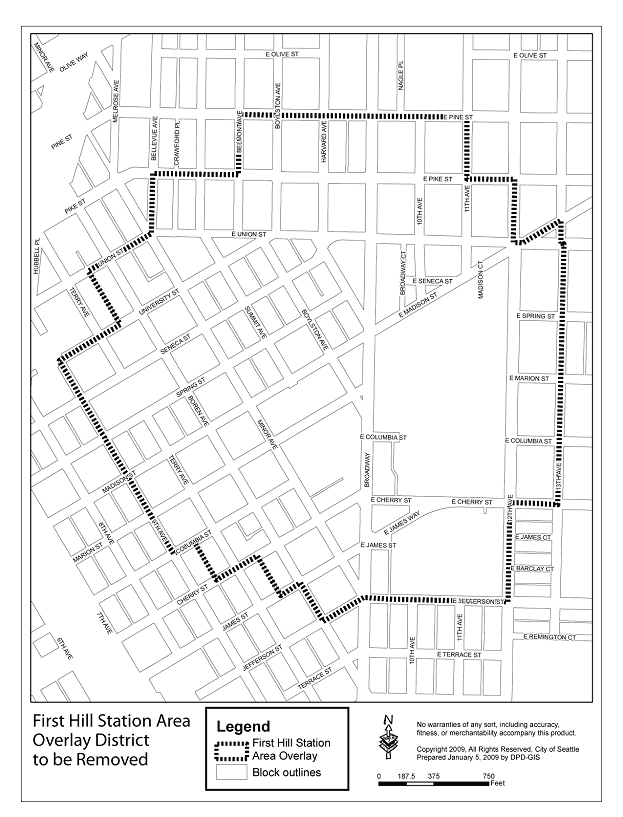
| AN ORDINANCE related to land use and zoning, amending Seattle Municipal Code (SMC) sections 23.73.002, 23.73.004, 23.73.006, 23.73.008, 23.73.010, 23.47A.005, 23.47A.012, 23.61.006, 23.61.012, 23.55.030, 23.84A.002, and 23.84A.006; adding a new section 23.73.009; and amending the Official Land Use Map at pages 110-111 to expand the boundaries of the Pike/Pine Overlay District, to rename the Overlay District the Pike/Pine Conservation Overlay District, to rezone land within the existing boundaries of the Pike/Pine Overlay District and one small area within the expanded overlay boundaries to add the Pedestrian zoning designation (suffix P), to designate additional principal pedestrian streets within the proposed pedestrian-designated zone, to remove the First Hill Station Area Overlay District, and to remove portions of the Capitol Hill Station Area Overlay District currently within the boundaries of the Pike/Pine Overlay District, in order to clarify the requirements of the Pike/Pine Overlay District and better maintain the character of the Pike/Pine neighborhood. | |
Description and Background | |
|---|---|
| Current Status: | Passed |
| Fiscal Note: | Fiscal Note to Council Bill No. 116508 |
| Index Terms: | ZONING, REZONES, CAPITOL-HILL |
| References: | Related: Clerk File 309945 |
Legislative History | |
|---|---|
| Sponsor: | RASMUSSEN; CO-SPONSOR: CLARK |
| Date Introduced: | April 20, 2009 |
| Committee Referral: | Planning, Land Use and Neighborhoods |
| City Council Action Date: | June 29, 2009 |
| City Council Action: | Passed |
| City Council Vote: | 9-0 |
| Date Delivered to Mayor: | June 30, 2009 |
|
Date Signed by Mayor: (About the signature date) | July 8, 2009 |
| Date Filed with Clerk: | July 8, 2009 |
| Signed Copy: | PDF scan of Ordinance No. 123020 |
Text | ||||||||||||||||||||||||||||||||||||||||||||||||||||||||||||||||||||||||||||||||||||||||||||||||||||||||||||||||||||||||||||||||||||||||||||||||||||||||||||||||||||||||
|---|---|---|---|---|---|---|---|---|---|---|---|---|---|---|---|---|---|---|---|---|---|---|---|---|---|---|---|---|---|---|---|---|---|---|---|---|---|---|---|---|---|---|---|---|---|---|---|---|---|---|---|---|---|---|---|---|---|---|---|---|---|---|---|---|---|---|---|---|---|---|---|---|---|---|---|---|---|---|---|---|---|---|---|---|---|---|---|---|---|---|---|---|---|---|---|---|---|---|---|---|---|---|---|---|---|---|---|---|---|---|---|---|---|---|---|---|---|---|---|---|---|---|---|---|---|---|---|---|---|---|---|---|---|---|---|---|---|---|---|---|---|---|---|---|---|---|---|---|---|---|---|---|---|---|---|---|---|---|---|---|---|---|---|---|---|---|---|---|
|
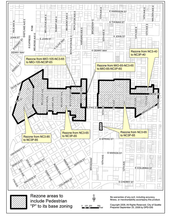
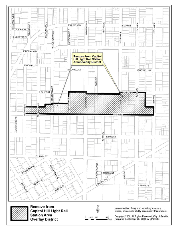
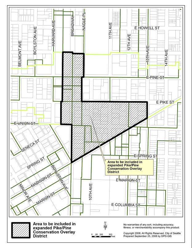
AN ORDINANCE related to land use and zoning, amending Seattle Municipal Code (SMC) sections 23.73.002, 23.73.004, 23.73.006, 23.73.008, 23.73.010, 23.47A.005, 23.47A.012, 23.61.006, 23.61.012, 23.55.030, 23.84A.002, and 23.84A.006; adding a new section 23.73.009; and amending the Official Land Use Map at pages 110-111 to expand the boundaries of the Pike/Pine Overlay District, to rename the Overlay District the Pike/Pine Conservation Overlay District, to rezone land within the existing boundaries of the Pike/Pine Overlay District and one small area within the expanded overlay boundaries to add the Pedestrian zoning designation (suffix P), to designate additional principal pedestrian streets within the proposed pedestrian-designated zone, to remove the First Hill Station Area Overlay District, and to remove portions of the Capitol Hill Station Area Overlay District currently within the boundaries of the Pike/Pine Overlay District, in order to clarify the requirements of the Pike/Pine Overlay District and better maintain the character of the Pike/Pine neighborhood. WHEREAS, in response to the 1991 Pike/Pine Planning Study sponsored and conducted by a coalition of Pike/Pine neighborhood and civic groups, business and property owners, and residents, the Pike/Pine Overlay District was established to preserve and enhance the area's mixed-use character; and WHEREAS, in March 1999, the City Council adopted Ordinance 119413 amending the City's Comprehensive Plan to include key goals and policies from the 1998 Pike/Pine Urban Center Village Plan. This Plan reaffirmed the neighborhood's commitment to mixed-use development, while identifying additional priorities including: 1) sustaining the character of Pike/Pine through implementation of urban design recommendations and policy changes and 2) considering a "conservation district" for the neighborhood; and WHEREAS, opportunities to implement these goals and policies exist through amending and expanding the existing Pike/Pine Overlay District; NOW, THEREFORE, BE IT ORDAINED BY THE CITY OF SEATTLE AS FOLLOWS: Section 1. The Official Land Use Map, Chapter 23.32 of the Seattle Municipal Code, is amended to expand the boundaries of the Pike/Pine Overlay District, located on pages 110 and 111 of the Official Land Use Map, to rename the district as the "Pike/Pine Conservation Overlay District," to add the Pedestrian zoning designation (suffix P) to all property within the existing boundaries of the District and one small area bounded by E. Union Street, Broadway Court, E. Seneca Street, and 10th Avenue located within the proposed boundaries of the District, to remove all property within the proposed boundaries of the District from the Capitol Hill Station Area Overlay District and to remove the First Hill Station Area Overlay District, all as shown on Exhibit A attached to this ordinance. Section 2. The title of Chapter 23.73 of the Seattle Municipal Code is amended as follows: Chapter 23.73 PIKE/PINE CONSERVATION OVERLAY DISTRICT Section 3. Section 23.73.002 of the Seattle Municipal Code, as enacted by Ordinance 117514, is amended as follows:
23.73.002 Purpose and intent
The purpose of this chapter is to implement Resolution 28657, calling for development of the Pike/Pine Overlay District in order to preserve and enhance the balance of residential and commercial uses, by encouraging residential development and
discouraging large, single-purpose commercial development. In addition, a purpose of this chapter is to promote the conservation of Pike/Pine's existing historic character by limiting new development to a scale that is compatible with the
established development pattern, accommodating arts facilities and small businesses at street level, and encouraging the retention of the existing structures and their architectural features that establish the District's architectural character;
generally, those structures that have been in existence for 75 years or more ("character structures") and are related to the area's early history as Seattle's original "auto row".
23.73.004 Pike/Pine Conservation Overlay District established
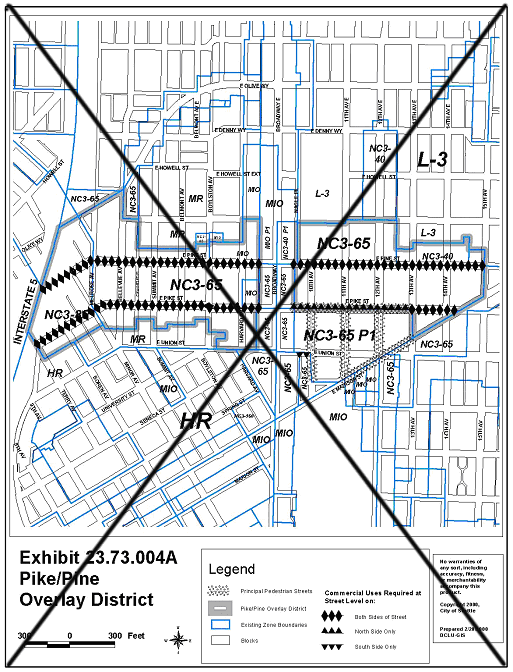
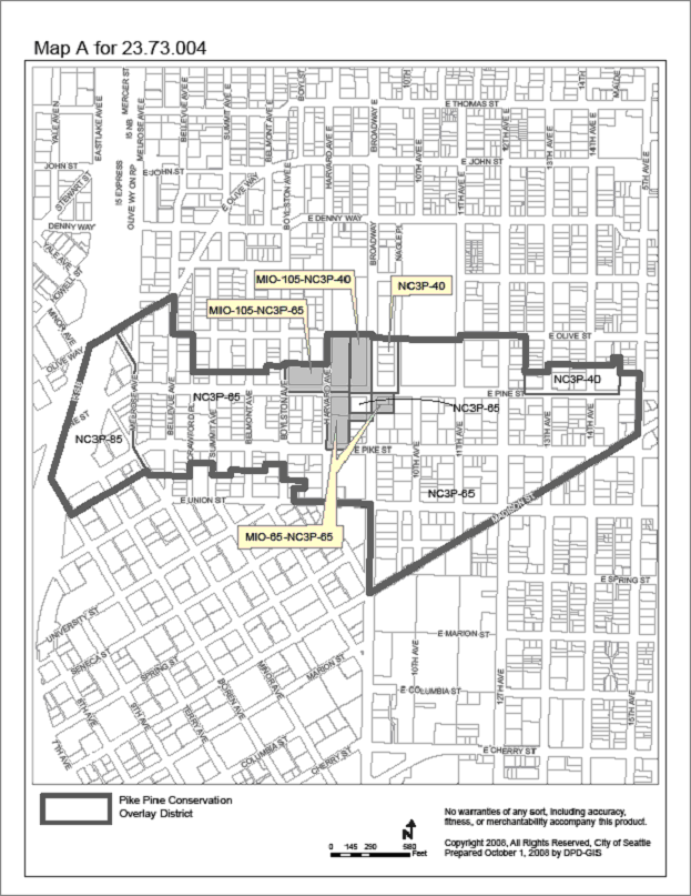
There is hereby established pursuant to Chapter 23.59 of the Seattle Municipal Code, the Pike/Pine Conservation Overlay District as shown on the Official Land Use Map, Chapter 23.32, and Map A for 23.73.004 Pike/Pine
Conservation Overlay District Exhibit 23.73.004A deleted Map Map A for 23.73.004 Section 5. Section 23.73.006 of the Seattle Municipal Code, as enacted by Ordinance 117514, is amended as follows:
23.73.006 Application of regulations
Land Section 6. Section 23.73.008 of the Seattle Municipal Code, which section was last amended by Ordinance 122311, is amended as follows:
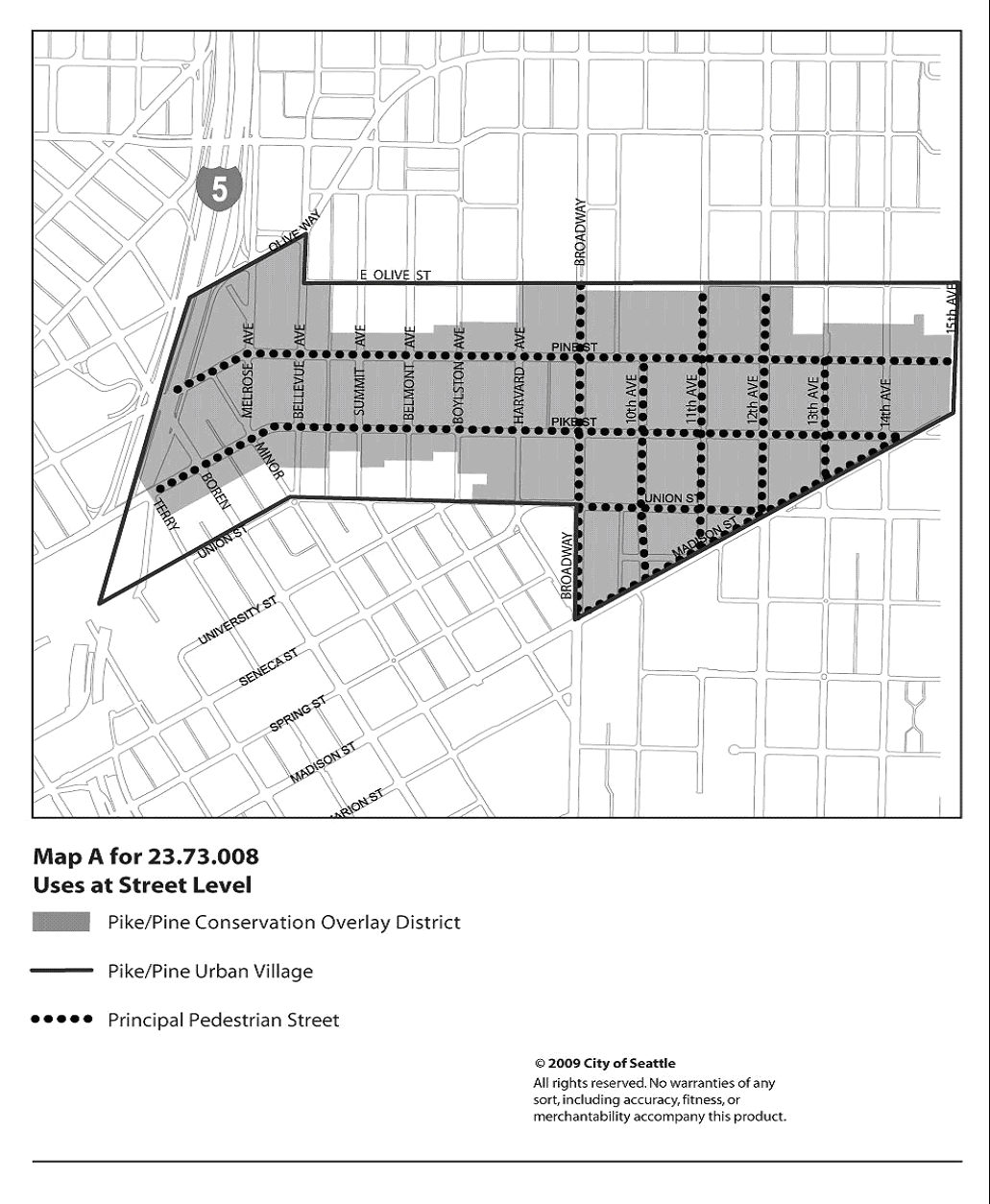
23.73.008 Uses at street level
East Pike Street;
East Pine Street; and
East Union Street, east of Broadway.
2. Residential uses may not exceed, in the aggregate, twenty (20) percent of the street-level street-facing facade along streets not listed in subsection B1 above, except that there is no limit on the location of residential uses in structures meeting
the following conditions:
a. The structure is located in an NC zone with a height limit of sixty-five (65) feet or more;
b. At least forty (40) percent of all units are rented to households at rents not exceeding thirty (30) percent of sixty (60) percent of the median income; and
c. Applicants demonstrate compliance with the condition in subsection B2b for the life of the building.
C. Nonresidential Use Limit. In all structures greater than thirty (30) feet in height, gross floor area in nonresidential use is limited to the lesser of fifty (50) percent of the structure's gross floor area, or the total gross floor area of the
first two (2) stories of the structure.
B. Space for small commercial uses at street level. All new structures that include more than 5,000 square feet of commercial uses at street level, excluding the floor area of performing arts theaters, arts facilities, and parking and access, shall
include commercial space(s) at street level for small, individual business establishments that average 2,000 square feet or less in size, according to Table A for 23.73.008.
This commercial space requirement applies to the total size of a business establishment, except that if a business establishment includes more than one principal use, each principal use within the business establishment may qualify as a small
business establishment.
C. The length of street frontage permitted for an individual business at street level within a new structure on Pike, East Pike, Pine, and East Pine Streets is limited to 50 feet. Portions of a business that are separated from the street by another
business or a different use that provides separate pedestrian access to the street are not limited in width. Map A for 23.73.008 Uses at Street Level Section 7. A new Section 23.73.009 is added to the Seattle Municipal code as follows: 23.73.009 Floor area ratio A. The floor area ratio (FAR) limits of the underlying zones for residential use apply to all structures and lots within the boundaries of the Pike/Pine Conservation Overlay District. B. The gross floor area of non-residential use is limited to a maximum of 2 FAR, except for the following: 1. For all structures greater than 30 feet in height, the gross floor area in non-residential use is limited to the lesser of 50 percent of the total gross floor area of all structures on a lot, or 2 FAR. 2. For development on a lot that meets all of the following conditions, the only limit on the gross floor area in non-residential uses shall be the FAR limit established by the underlying zoning for nonresidential uses: a. The lot is 18,000 square feet in area or less; b. The lot abuts a street that is a boundary of the Pike/Pine Conservation Overlay District; and c. The lot is across a street from a lot that is: 1) zoned NC3 65 or NC3P 65; 2) located outside the Pike/Pine Conservation Overlay District; and 3) is not located within a Major Institution Overlay Zone. C. In addition to the floor area exempt under the provisions of the underlying zone, the following floor area is exempt from the calculation of gross floor area subject to an FAR limit and from the limit on nonresidential use in 23.73.009.B: 1. Non-residential use located in a character structure, provided that the non-residential use does not displace an existing residential use. 2. New non-residential floor area added to a character structure, provided that the added floor area does not exceed the equivalent of 0.5 FAR, as calculated on the lot occupied by the character structure at the time it was built. 3. Street level commercial uses complying with the standards of 23.47A.008 and 23.73.008.B. 4. Floor area used for the creation, display, performance or screening of art for members of the general public and floor area used by an arts facility. 5. All floor area in residential use in a development that meets the provisions of 23.73.010.C, provided that development of the lot does not require the removal of a character structure identified on Table A for 23.73.010. 6. In areas where the underlying zoning is NC3P/65, all floor area in residential use on a lot that is 8,000 square feet or less in area and has been either vacant or in parking use as of February 27, 1995. Section 8. Section 23.73.010, of the Seattle Municipal Code, which section was last amended by Ordinance 122311, is amended as follows:
23.73.010 Development standards
A. Floor size limit.
1. On lots greater than 15,000 square feet in size, the maximum gross floor area of any single story above 35 feet in height is 15,000 square feet. The floor size limit shall not apply to nonresidential uses in a structure developed on a lot pursuant
to subsection 23.73.009.B.2.
3. Internal connections above 35 feet in height between new portions of a structure on the same lot and between separate structures on abutting lots are not permitted, unless the structure on the abutting lot is a character structure.
4. For a project that retains the whole of a character structure on the lot, any floor area above 35 feet in height within the character structure, whether connected to a new structure or not, is not included in the calculation of the floor area
subject to the limit on floor size.
1. Conditions in the vicinity of the lot minimize the impact of additional development bulk on the existing character of the area. Such conditions include locations on the edges of the Pike/Pine Conservation Overlay District where development on large
lots already exists, or where irregularities in the street grid have created small blocks or a single lot surrounded on all sides by streets; or
2. The proposed new project includes features that offset the perceived scale of development, such as a landscaped courtyard that is visible from the sidewalk and located primarily at street level on a street that is not a principal pedestrian street;
or
3. The increase in floor size is for a mixed use project that includes uses contributing to the area's recognized character as an arts district, including performing arts space and artist live/work space, which typically have design requirements, such
as non-standard floor to ceiling heights, that reduce the total amount of usable floor area in a structure; or
4. The additional floor area will facilitate development of housing that is affordable to and occupied by "income-eligible households," as defined in Section 23.58A.004, for a minimum of 50 percent of the total gross floor area of the project and is
subject to covenants ensuring that the housing remains available to these households for a minimum of 50 years.
C. Retaining character structures on a lot. A 25 percent increase in the floor size limit above 35 feet in height is permitted for projects that incorporate a character structure on the same lot, either as a whole structure or as a portion of
a structure, pursuant to the following provisions.
1. No increase in floor size is permitted under the provisions of this subsection for a project that will result in the demolition of a designated Seattle Landmark or a character structure identified on Table A for 23.73.010.
2. For a project that incorporates portions of a character structure, the following conditions shall be met:
a. All street facing facades of the character structure are retained;
and
b. All portions of the new structure above the height of the street facing facades of the character structure are set back a minimum of 15 feet from all street property lines that abut the character structure.
3. As an alternative to the provisions of subsection 23.73.010.C.2, the Director may, as a Type I decision, waive or modify the conditions of this subsection, based on the following:
a. The portion of the structure that is retained is sufficient to give the appearance of a free-standing building; or
b. The newly constructed portion of the project, through vertical or horizontal modulation or other design treatments, generally provides for a better integration of the existing structure with the new project, in terms of both physical appearance and
the arrangement of interior spaces, than would otherwise occur through the strict application of the standards in subsection 23.73.010.C.1; or
c. Additional flexibility is necessary to maintain a character structure on a small development lot that is 8,000 square feet in size or less.
4. Any floor area in a new portion of the structure above 35 feet in height that is within the area of the original footprint of the character structure and is separated from the street along all street frontages by the original facades of the
character structure is not included in the calculation of the floor area subject to the floor size limit.
5. A project that is granted an increase in floor size under the provisions of this subsection 23.73.010.C shall maintain the character structure, or portions of the character structure, both interior and exterior, in good condition and repair and in a
manner that preserves unique features and characteristics for the life of the project. Any increase in floor size permitted pursuant to this Section 23.73.010.C shall not be combined with any increase in floor size permitted pursuant to Section
23.73.010.B.
D. Maximum structure width.
1. For each block face abutting Pike, East Pike, Pine, or East Pine Streets, the maximum width of all portions of a structure measured along the street property line is 1/2 the total width of all lots on the block face.
2. The limit on width shall not apply to the following:
a. Portions of a new structure separated from the street property line by another lot or another structure located on the same lot, provided that abutting structures are not connected internally, either above or below grade, unless the abutting
structure is a character structure;
b. Development on lots on blocks abutting Crawford Place, because of the narrow block width; and
c. Portions of a new structure separated from the street property line by a character structure, or the remaining portions of a character structure included in a project pursuant to the provisions of 23.73.010.C.
1.
2. 3. The transparency requirements for street-facing facades in 23.47A.008.A.2 shall apply to the portion of the street-facing facade between 2 feet and 12 feet above the sidewalk. Only clear or lightly tinted glass shall be considered transparent.
F. Height exception for lots that include a character structure. In zones with a mapped height limit of 65 feet, or with a 40 foot mapped height limit with provisions allowing for additional height up to 65 feet pursuant to subsection
23.47A.012.A, the Director may permit the height of a structure to exceed the height limit of the zone by 10 feet, subject to the following:
1. Residential Amenity space is not required for structures existing as of April 1, 2000, that are repaired, renovated or structurally altered to the extent permitted by the development standards of the Land Use Code, provided that street facing
facades are retained and 2. Residential Amenity space is not required for new construction, when affordable housing that meets the following criteria is provided by a nonprofit organization:
a. At least b. Applicants demonstrate compliance with these income criteria for the life of the building.
3. Existing residential uses that meet the residential amenity requirements of Section 23.47A.024, Residential amenity standards, may eliminate residential amenity space, provided they comply with the requirements of Section 23.73.010
2. Location of Parking. Parking for residential uses shall be provided on the same lot as the principal use. Section 9. Subsection E of Section 23.47A.005 of the Seattle Municipal Code, which Section was enacted by Ordinance 122935, is amended as follows: 23.47A.005 Street-level uses *** D. In pedestrian-designated zones the locations of uses are regulated as follows: 1. Along designated principal pedestrian streets, one or more of the following uses are required along 80 percent of the street-level streetfacing facade in accordance with the standards provided in subsection 23.47A.008.C. a. General sales and services; b. Major durables retail sales; c. Eating and drinking establishments; d. Lodging uses; e. Theaters and spectator sports facilities; f. Indoor sports and recreation; g. Medical services; h. Rail transit facilities; i. Museum; j. Community clubs or centers; k. Religious facility; l. Library; m. Elementary or secondary school;
n. Parks and open space
o. Arts facility in the Pike/Pine Conservation Overlay District;
p. Automotive retail sales and service uses in the Pike/Pine Conservation Overlay District, if located within an existing structure.
2. The following streets are principal pedestrian streets when located within a pedestrian-designated zone: 10th Avenue; 11th Avenue; 12th Avenue;
13th Avenue (between East Madison Street and East Pine Street);
15th Avenue Northwest; 22nd Avenue Northwest; 23rd Avenue; 24th Avenue Northwest; 25th Avenue Northeast; Beacon Avenue South; Boren Avenue; Boylston Avenue; Broadway; Broadway East; California Avenue Southwest; East Green Lake Drive North; East Madison Street; East Olive Way; East Pike Street;
East Pine Street:
East Union Street (from Broadway to East Madison Street only);
First Avenue North; Fremont Avenue North; Fremont Place North; Greenwood Avenue North; Lake City Way Northeast; Madison Street; Martin Luther King Jr. Way South; Mercer Street;
North 45th Street;
Northeast 43rd Street; Northeast 45th Street; Northeast 125th Street; Northwest 85th Street; Northwest Market Street;
Pike Street;
Pine Street;
Rainier Avenue South; Roosevelt Way Northeast; Roy Street; South Alaska Street; South Henderson Street; South Lander Street; South McClellan Street; South Othello Street; Southwest Alaska Street; Summit Avenue; Terry Avenue; University Way Northeast; Wallingford Avenue North; and Woodlawn Avenue Northeast. Section 10. Subsection 23.47A.012.A of the Seattle Municipal Code, which Section was last amended by Ordinance 122935, is amended as follows: 23.47A.012 Structure height
A. The height limit for structures in NC zones or C zones is 30 feet, 40 feet, 65 feet, 85 feet, 125 feet, or 160 feet, as designated on the Official Land Use Map, Chapter 23.32. Structures may not exceed the applicable height limit, except as
otherwise provided in this section. Within the South Lake Union Urban Center, any modifications or exceptions to maximum structure height are allowed solely according to the provisions of the Seattle Mixed Zone, subsections
23.48.010.B.1 1. In zones with a 30 foot or 40 foot mapped height limit: a. the height of a structure may exceed the otherwise applicable limit by up to 4 feet, subject to subsection 23.47A.012.A.1.c, provided the following conditions are met: 1) Either i. A floor-to-floor height of 13 feet or more is provided for nonresidential uses at street level; or ii. A residential use is located on a street-level, street facing facade, and the first floor of the structure at or above grade is at least 4 feet above sidewalk grade; and 2) The additional height allowed for the structure will not allow an additional story beyond the number that could be built under the otherwise applicable height limit. b. The height of a structure may exceed the otherwise applicable limit by up to 7 feet, subject to subsection 23.47A.012.A.1.c, provided all of the following conditions are met: 1) Residential and multipurpose retail sales uses are located in the same structure; 2) The total gross floor area of at least one multi-purpose retail sales use exceeds 12,000 square feet; 3) A floor-to-floor height of 16 feet or more is provided for the multi-purpose retail sales use at street level; 4) The additional height allowed for the structure will not allow an additional story beyond the number that could be built under the otherwise applicable height limit if a 16 foot floorto-floor height were not provided at street level; and 5) The structure is not allowed additional height under subsection 23.47A.012.A.1.a. c. The Director shall reduce or deny the additional structure height permitted by this subsection 23.47A.012.A.1 if the additional height otherwise would significantly block views from neighboring residential structures of any of the following: Mount Rainier, the Olympic and Cascade Mountains, the downtown skyline, Green Lake, Puget Sound, Lake Washington, Lake Union, and the Ship Canal.
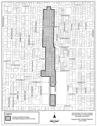
2. For any lot within the designated areas shown on Map A for 23.47A.012, the height limit in NC zones or C zones designated with a 40foot height limit on the Official Land Use Map may be increased to 65 feet and may contain floor area as permitted
for a 65 Map A of 23.47A.012 3. Monorail transit facilities may exceed the height limit of the zone according to the provisions of Section 23.80.004 or Section 15.54.020. 4. Within the South Lake Union Urban Center, maximum structure height shall be determined according to the provisions of the Seattle Mixed Zone, Section 23.48.010.
5. Within the Station Area Overlay District within the University District Northwest Urban Center Village, maximum structure height may be increased to
a. The lot is within two
b. The proposed use of the lot is functionally related to other office development, permitted prior to 1971, to have over c. A transportation management plan for the life of the use includes incentives for light rail and other transit use by the employees of the office use; d. The development shall provide street level amenities for pedestrians and shall be designed to promote pedestrian interest, safety, and comfort through features such as landscaping, lighting and transparent facades, as determined by the Director; and e. This subsection can be used only once per functionally related development.
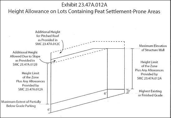
6. On a lot containing a peat settlement-prone environmentally critical area, the height of a structure may exceed the otherwise applicable height limit and the other height allowances provided by this section by up to a. The Director finds that locating a story of parking underground is infeasible due to physical site conditions such as a high water table;
b. The Director finds that the additional height allowed for the structure is necessary to accommodate parking located partially below grade that extends no more that
c. Other than the additional story of parking allowed pursuant to
7. In zones with a 65 foot mapped height limit or with a 40 foot mapped height limit with provisions allowing for additional height up to 65 feet pursuant to subsection 23.47A.012.A.2 that are located within the Pike/Pine Conservation Overlay
District, the provisions of Section 23.73.010 apply.
Section 11. Section 23.61.006 of the Seattle Municipal Code, which Section was last amended by Ordinance 122043, is amended as follows:
23.61.006 Application of Regulations
All land located within the Station Area Overlay District is subject to the regulations of the underlying zone unless specifically modified by the provisions of this chapter. In the event of a conflict between the provisions of the Station Area Overlay
District and the underlying zone including Pedestrian-Designated Zones, the provisions of this chapter prevail. Where a conflict exists between the provisions of this chapter and Section 12. Section 23.61.012 of the Seattle Municipal Code, which Section was last amended by Ordinance 122311, is amended as follows:
23.61.012 Residential structures
Residential uses are permitted outright anywhere in a structure in C zones and NC zones, unless located on a lot in a pedestrian-designated zone, where they are limited to 20 Section 13. Section 23.55.030 of the Seattle Municipal Code, which Section was last amended by Ordinance 121782, is amended as follows:
23.55.030 Signs in NC3, C1, C2 and SM zones
A. No sign shall have rotating or moving parts that revolve at a speed in excess of B. Signs may be electric, externally illuminated, nonilluminated or may use video display methods when the sign meets the development standards in Section 23.55.005, Video display methods. C. No flashing signs shall be permitted.
D. In the Pike/Pine Conservation Overlay District, internally illuminated cabinet signs and backlit awning signs are prohibited.
1. The following signs shall be permitted in addition to the signs permitted by subsections
a. Electric, externally illuminated or nonilluminated signs bearing the name of the occupant of a dwelling unit, not exceeding b. Memorial signs or tablets, and the names of buildings and dates of building erection when cut into a masonry surface or constructed of bronze or other noncombustible materials; c. Signs for public facilities indicating danger and/or providing service or safety information; d. Properly displayed national, state and institutional flags;
e. One
f. One 2. Number and Type of Permitted Signs for Business Establishments.
a. Each business establishment may have one
b. In addition to the signs permitted by
c. In addition to the signs permitted by
d. Individual businesses which are not drive-in businesses and which are not located in multiple business centers may have one
e. Where the principal use or activity on the lot is outdoor retail sales, banners and strings of pennants maintained in good condition shall be permitted in addition to the signs permitted by subsections
3. Maximum Area. a. NC3 Zones and the SM zone.
(1) The maximum area of each face of a pole, ground, roof, projecting or combination signs shall be
i. The maximum area for signs for multiple business centers, and signs for business establishments located within
ii. The maximum area for pole signs for gas stations which identify the price of motor fuel being offered by numerals of equal size shall be (2) There shall be no maximum area limit for wall, awning, canopy, marquee or under-marquee signs. b. C1 and C2 Zones. There shall be no maximum area limits for onpremises signs for business establishments in C1 and C2 zones. 4. Identification Signs for Multifamily Structures.
a. One b. Identification signs may be wall, ground, awning, canopy, marquee, under-marquee, or projecting signs.
c. The maximum area of each sign shall be 5. Sign Height.
a. The maximum height for any portion of a projecting or combination sign shall be
b. The maximum height limit for any portion of a pole sign shall be
c. The maximum height for any portion of a wall, marquee, under-marquee or canopy sign shall be d. No portion of a roof sign shall: (1) Extend beyond the height limit of the zone; (2) Exceed a height above the roof in excess of the height of the structure on which the sign is located; or
(3) Exceed a height of
1. Identifying Signs for Business Districts. Each business district may have up to two
2. One
3. When accessory parking is provided on a lot other than the lot where the principal use is located, off-premises directional signs
4. Off-premises directional signs and advertising signs, in addition to those permitted by subsections 5. Advertising signs are prohibited in Neighborhood Commercial 3 zones and in the Seattle Mixed (SM) zone. 6. Sign kiosks as provided in Section 23.55.015 are permitted.
Section 14. Section 23.84A.002 A of the Seattle Municipal Code, which Section was last amended by Ordinance 122411, is amended as follows:
23.84A.002 "A * * *
"Arts facility" means space occupied by one or more not-forprofit organizations dedicated to the creation, display, performance or screening of art by or for members of the general public.
Section 15. Section 23.84A.006 C of the Seattle Municipal Code, which Section was last amended by Ordinance 122411, is amended as follows:
23.84A.006 "C * * *
"Character structure" means a structure on a lot within the boundaries of the Pike/Pine Conservation Overlay District that has been in existence for at least 75 years, thereby contributing to the established scale, development pattern, and
architectural character of the area.
Section 16. This ordinance shall take effect and be in force thirty (30) days from and after its approval by the Mayor, but if not approved and returned by the Mayor within 10 days after presentation, it shall take effect as provided by Municipal Code Section 1.04.020. Passed by the City Council the ____ day of _________, 2009, and signed by me in open session in authentication of its passage this _____ day of __________, 2009. _________________________________ President __________of the City Council Approved by me this ____ day of _________, 2009. _________________________________ Gregory J. Nickels, Mayor Filed by me this ____ day of _________, 2009. ____________________________________ City Clerk (Seal) Exhibit A: Rezone Maps Exhibit A to Pike/Pine Conservation Overlay District Ordinance EXHIBIT A: Rezone Maps: Exhibit A Rezone areas to include Pedestrian "P" to its base zoning Exhibit A Remove from Capitol Hill Light Rail Station Area Overlay District Map Exhibit A Area to be included in expanded Pike/Pine Conservation Overlay District Exhibit A First Hill Station Area overlay District to be Removed Map |
||||||||||||||||||||||||||||||||||||||||||||||||||||||||||||||||||||||||||||||||||||||||||||||||||||||||||||||||||||||||||||||||||||||||||||||||||||||||||||||||||||||||
Attachments |
|---|
![[TOP]](/netaicon/toppg.gif)