

![[HOME]](/netaicon/homeicon.gif)
![[SEARCH]](/netaicon/srchpage.gif)

![[CURR_LIST]](/netaicon/curlist.gif)


![[BOTTOM]](/netaicon/bottom.gif)
![[HELP]](/netaicon/help.gif)
Seattle City Council Bills and Ordinances
Information modified on July 6, 2001; retrieved on April 23, 2024 3:06 AM
Ordinance 120457
Introduced as Council Bill 113745
Title | |
|---|---|
| AN ORDINANCE relating to land use and zoning, amending Plat 73W, page 173, and Plat 73E, page 174, of the Official Land Use Map, Seattle Municipal Code (SMC) Chapter 23.32, to rezone properties near the proposed Othello light rail station (these properties are generally located along Martin Luther King Jr. Way South from South Willow Street to South Webster Street and along South Othello Street from 38th Avenue South to 43rd Avenue South) and to designate boundaries for the Station Area Overlay District near the proposed Othello light rail station; amending SMC Section 23.47.040 to designate principal pedestrian streets; and amending SMC Section 23.70.004 to delete Exhibit 1B. | |
Description and Background | |
|---|---|
| Current Status: | Passed |
| Index Terms: | BRIGHTON, HOLLY-PARK, DUNLAP, SOUTH-BEACON-HILL, RAINIER-VALLEY, LAND-USE-CODE, TRANSPORTATION-PLANNING, REZONES, LAND-USE-REGULATIONS, MASS-TRANSIT, ZONING |
| References: | Ord 119394; CB 113740; Res. 29867, 30128, 30165, 29942, 29830, 29979, 29976, 29995, 29869, 29903, 29808 |
Legislative History | |
|---|---|
| Sponsor: | NICASTRO |
| Date Introduced: | July 9, 2001 |
| Committee Referral: | Landlord/Tenant and Land Use |
| City Council Action Date: | July 30, 2001 |
| City Council Action: | Passed |
| City Council Vote: | 6-3 (No: Licata, Nicastro, Steinbrueck) |
| Date Delivered to Mayor: | July 30, 2001 |
|
Date Signed by Mayor: (About the signature date) | July 31, 2001 |
| Date Filed with Clerk: | July 31, 2001 |
| Signed Copy: | PDF scan of Ordinance No. 120457 |
Text | |
|---|---|
|
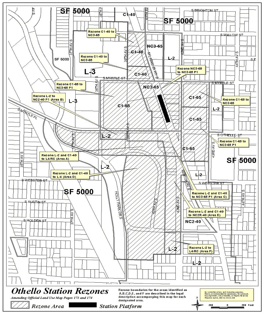
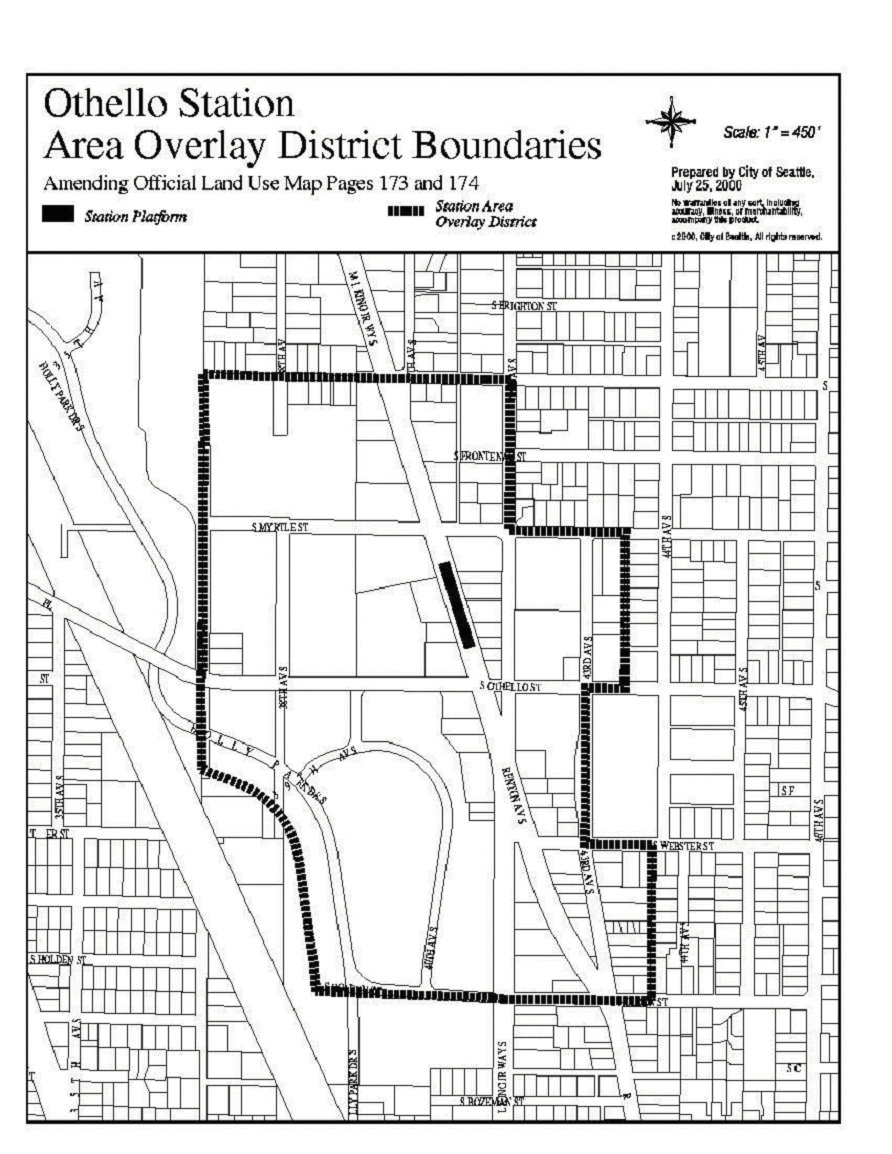
AN ORDINANCE relating to land use and zoning, amending Plat 73W, page 173, and Plat 73E, page 174, of the Official Land Use Map, Seattle Municipal Code (SMC) Chapter 23.32, to rezone properties near the proposed Othello light rail station (these properties are generally located along Martin Luther King Jr. Way South from South Willow Street to South Webster Street and along South Othello Street from 38th Avenue South to 43rd Avenue South) and to designate boundaries for the Station Area Overlay District near the proposed Othello light rail station; amending SMC Section 23.47.040 to designate principal pedestrian streets; and amending SMC Section 23.70.004 to delete Exhibit 1B. WHEREAS, RCW 81.104 directs municipalities to regulate land uses in a manner that supports high capacity transportation systems; and WHEREAS, in November 1996, the voters of the three-county Sound Transit district approved Sound Move, the ten-year regional transit system plan, which includes a 23-mile new electric light rail line connecting SeaTac, Tukwila, and Seattle; and WHEREAS, Sound Transit is proceeding to implement the Sound Move plan, including the light rail component; and WHEREAS, in April 1998, the City of Seattle and Sound Transit executed a Memorandum of Agreement for Intergovernmental Cooperation for the Central Link Light Rail Transit Project (hereinafter, the MOA), as authorized by Ordinance 118927; and WHEREAS, under the terms of the MOA, the City has been conducting station area planning and related public involvement activities for light rail station areas in Seattle; and WHEREAS, the City Council adopted Resolution 29867 in December 1998, establishing goals and strategies to promote transit-oriented development in light rail station areas; and WHEREAS, the City has given guidance to Sound Transit as to preferred light rail routes and station locations, and desired patterns for development around light rail stations, in previous legislation, including Resolution 29904 adopted on February 22, 1999; and WHEREAS, on February 25, 1999, the Sound Transit Board of Directors identified the Locally Preferred Alternative (LPA) light rail alignment and station locations; and WHEREAS, on November 18, 1999, the Sound Transit Board selected and authorized the implementation of the Locally Preferred Alternative alignment for the Central Link Light Rail Project and station locations; and WHEREAS, On April 10, 2000, the City Council adopted Resolution 30128, approving the light rail alignment, station locations, and maintenance base location for the Central Link Light Rail Project in the City of Seattle; and WHEREAS, the City Council adopted Resolution 30165 in September 2000, approving concept-level station area planning recommendations for the areas around the light rail stations; and WHEREAS, the Station Area Interim Overlay District was established in March 1999 by Ordinance 119394, which expires on September 1, 2001, around proposed Sound Transit Link light rail stations for the purpose of preserving opportunities for transit and pedestrianoriented development in accordance with Council approved goals and objectives; and WHEREAS, the City Council established a new Chapter 23.70, Station Area Overlay District (C.B. 113740), to the Seattle Municipal Code, establishing permanent regulations to prohibit uses incompatible with transit-oriented development and revising development standards within approximately one-quarter mile of proposed Sound Transit light rail stations; and WHEREAS, the City Council adopted Resolutions 29942, 29830, 29979, 29976, 29995, 29869, 29903 and 29808 in 1998 through 1999, approving neighborhood plans applicable to each of the station areas affected by this ordinance; and WHEREAS, the City Council finds that this ordinance should be adopted for the reasons contained in the Executive Analysis and Recommendation, and WHEREAS, the City Council finds that these proposed amendments will implement the policies contained in RCW 81.104 and be consistent with the resolutions identified above, and will promote the health, safety and welfare of the general public, NOW THEREFORE, BE IT ORDAINED BY THE CITY OF SEATTLE AS FOLLOWS: Section 1. The Official Land Use Map, Chapter 23.32 of the Seattle Municipal Code is amended to rezone certain properties located on Plat 73W, page 173, and Plat 73E, page 174, of the Official Land Use Map, as shown on Exhibit A and described in Exhibit B, as it pertains to property owned by the Seattle Housing Authority, attached to this ordinance. Those parcels rezoned to Lowrise 4 and Lowrise 4/Residential Commercial that are located within Areas A, D and F as shown on Exhibits A and B are restricted as follows: the allowable density shall be restricted to the density in a Lowrise 2 zone prescribed by SMC 23.45.008(A). Section 2. The Official Land Use Map, Chapter 23.32 of the Seattle Municipal Code is amended to designate the boundaries of the Station Area Overlay District on Plat 73W, page 173, and Plat 73E, page 174, of the Official Land Use Map, as shown on Exhibit C attached to this ordinance. Section 3. Subsection C of Section 23.47.040 of the Seattle Municipal Code, which Section was last amended by Ordinance {Henderson Rezone Ordinance}, is amended to add new principal pedestrian streets as follows: 23.47.040 General provisions for pedestrian-designated zones. * * * C. For purposes of this subchapter, the following streets are principal pedestrian streets when located within a pedestriandesignated zone: 10th Avenue; 11th Avenue; 12th Avenue; 15th Avenue East; 23rd Avenue; 25th Avenue Northeast; Broadway; California Avenue Southwest; East Union Street; East Greenlake Drive North; East Madison Street; East Olive Way; East Pike Street; First Avenue North; Fremont Avenue North; Fremont Place North; Greenwood Avenue North; Lake City Way Northeast; Madison Street; Martin Luther King Jr. Way South; Mercer Street; North 85th Street; Northeast 45th Street; Northwest Market Street; Queen Anne Avenue North; Rainier Avenue South; Roosevelt Way Northeast; Roy Street; South Henderson Street; South Othello Street; Southwest Alaska Street; University Way Northeast; and Woodlawn Avenue Northeast. Section 4. Section 23.70.004 of the Seattle Municipal Code, which Section was last amended by Ordinance {Henderson Rezone Ordinance}, is further amended to delete Exhibit 1B. Section 5. The City Clerk is hereby authorized and directed to file a copy of this ordinance and attached Exhibits A, B and C at the King County Records and Elections Division, and to deliver copies of the same to the Director of the Department of Design, Construction and Land Use and to the King County Assessor's Office. Section 6. The provisions of this ordinance are declared to be separate and severable. The invalidity of any particular provision shall not affect the validity of any other provision. Section 7. This ordinance shall take effect and be in force thirty (30) days from and after its approval by the Mayor, but if not approved and returned by the Mayor within ten (10) days after presentation, it shall take effect as provided by Municipal Code Section 1.04.020. Passed by the City Council the ___ day of ____________, 2001, and signed by me in open session in authentication of its passage this ___ day of _____________, 2001. ___________________________________ President of the City Council Approved by me this _____ day of _________________, 2001. ___________________________________ Paul Schell, Mayor Filed by me this _____ day of ____________________, 2001. ___________________________________ City Clerk Exhibit A Rezone Map Those parcels rezoned to Lowrise 4 and Lowrise 4/Residential Commercial that are located within Areas A, D and F as shown on Exhibits A and B are restricted as follows: the allowable density shall be restricted to a density in a Lowrise 2 zone prescribed by SMC 23.45.008(A). Exhibit B Legal Description Exhibit C Station Area Overlay District Boundaries LEGAL DESCRIPTION (For areas to be rezoned, among Areas A H) AREA A BEGINNING AT THE INTERSECTION OF THE EASTERLY MARGIN OF THE CITY OF SEATTLE TRANSMISSION LINE RIGHT-OF WAY AND THE SOUTHERLY MARGIN OF MYRTLE PLACE, SAID POINT BEING LOCATED IN THE NORTHWEST QUARTER OF THE SOUTHWEST QUARTER OF SECTION 27, TOWNSHIP 24 NORTH, RANGE 4 EAST, W.M. IN KING COUNTY, WASHINGTON; THENCE SOUTH 63nvironmental07'45" EAST ALONG THE SOUTHERLY MARGINS OF MYRTLE PLACE AND OTHELLO STREET A DISTANCE OF 103.03 FEET TO THE TRUE POINT OF BEGINNING; THENCE CONTINUING SOUTH 63nvironmental07'45" EAST ALONG SAID MARGIN A DISTANCE OF 91.26 FEET ; THENCE CONTINUING ALONG SAID MARGIN ON THE ARC OF A 530.00 FOOT RADIUS TANGENT CURVE TO THE LEFT THROUGH A CENTRAL ANGLE OF 27nvironmental40'27", FOR A DISTANCE OF 255.99 FEET. THENCE CONTINUING NORTH 89nvironmental11'48" EAST ALONG SAID MARGIN A DISTANCE OF 216.25 FEET TO A POINT HEREINAFTER CALLED POINT "A" THENCE SOUTH 00nvironmental30'00" EAST A DISTANCE OF 82.97 FEET ; THENCE NORTH 89nvironmental30'00" EAST A DISTANCE OF 322.37 FEET ; THENCE SOUTH 00nvironmental30'00" EAST A DISTANCE OF 17.75 FEET ;TO A POINT HEREINAFTER CALLED "B" THENCE NORTH 89nvironmental30'00" EAST A DISTANCE OF 428.70 FEET ; THENCE SOUTH 13nvironmental19'00" EAST A DISTANCE OF 198.08 FEET TO A POINT HEREINAFTER CALLED "D"; THENCE SOUTH 89nvironmental30'00" WEST A DISTANCE OF 481.55 FEET TO A POINT HEREINAFTER CALLED "C"; THENCE CONTINUING SOUTH 89nvironmental30'00" WEST A DISTANCE OF 370.86 FEET ; THENCE ALONG THE ARC OF A 175.00 FOOT RADIUS TANGENT CURVE TO THE RIGHT THROUGH A CENTRAL ANGLE OF 25nvironmental16'00", FOR A DISTANCE OF 77.17 FEET. THENCE NORTH 65nvironmental14'00" WEST A DISTANCE OF 340.56 FEET ; THENCE ALONG THE ARC OF A 195.00 FOOT RADIUS TANGENT CURVE TO THE RIGHT THROUGH A CENTRAL ANGLE OF 81nvironmental17'10", FOR A DISTANCE OF 276.65 FEET TO THE TRUE POINT OF BEGINNING CONTAINING 276,941 SQUARE FEET OR 6.36 ACRES OF LAND MORE OR LESS AREA B BEGINNING AT AFOREMENTIONED "POINT A"; THENCE NORTH 89nvironmental11'48" EAST ALONG THE SOUTHERLY MARGIN OF OTHELLO STREET A DISTANCE OF 322.37 FEET ; THENCE SOUTH 00nvironmental30'00" EAST A DISTANCE OF 84.67 FEET ; THENCE SOUTH 89nvironmental30'00" WEST A DISTANCE OF 322.37 FEET ; THENCE NORTH 00nvironmental30'00" WEST A DISTANCE OF 82.97 FEET ; TO THE TRUE POINT OF BEGINNING ("POINT A") CONTAINING 27,021 SQUARE FEET OR 0.62 ACRES OF LAND MORE OR LESS AREA C BEGINNING AT AFORMENTIONED "POINT B"; THENCE NORTH 00nvironmental30'00" WEST A DISTANCE OF 102.42 FEET TO THE SOUTHERLY MARGIN OF OTHELLO STREET; THENCE NORTH 89nvironmental11'48" EAST ALONG THE SOUTHERLY MARGIN OF OTHELLO STREET A DISTANCE OF 496.36 FEET TO THE WESTERLY MARGIN OF MARTIN LUTHER KING JUNIOR WAY SOUTH; THENCE SOUTH 18nvironmental06'45" EAST ALONG SAID WESTERLY MARGIN A DISTANCE OF 174.91 FEET TO A POINT OF CURVE; THENCE CONTINUING ALONG SAID WESTERLY MARGIN ON SAID CURVE TO THE RIGHT HAVING A RADIUS OF 1000.00 FEET THROUGH A CENTRAL ANGLE OF 7nvironmental45'42", AN ARC DISTANCE OF 135.47 FEET; THENCE SOUTH 89nvironmental30'00" WEST A DISTANCE OF 108.77 FEET TO A POINT HEREINAFTER CALLED "D"; THENCE NORTH 13nvironmental19'00" WEST A DISTANCE OF 198.08 FEET ; THENCE SOUTH 89nvironmental30'00" WEST A DISTANCE OF 428.70 FEET ; TO THE TRUE POINT OF BEGINNING ("POINT B") CONTAINING 74,004 SQUARE FEET OR 1.70 ACRES OF LAND MORE OR LESS AREA D BEGINNING AT AFORMENTIONED "POINT C"; THENCE NORTH 89nvironmental30'00" EAST A DISTANCE OF 481.55 FEET ; THENCE SOUTH 00nvironmental30'00" EAST A DISTANCE OF 1030.08 FEET TO A POINT HEREINAFTER CALLED "E"; THENCE CONTINUING SOUTH 00nvironmental30'00" EAST A DISTANCE OF 290.04 FEET TO THE CENTER LINE OF VACATED SOUTH CHICAGO STREET; THENCE SOUTH 89nvironmental10'26" WEST ALONG SAID CENTER LINE A DISTANCE OF 137.47 FEET ; THENCE SOUTH 01nvironmental12'56" EAST A DISTANCE OF 79.27 FEET ; THENCE NORTH 89nvironmental45'26" WEST A DISTANCE OF 338.87 FEET ; THENCE NORTH 00nvironmental30'00" WEST A DISTANCE OF 375.76 FEET ; THENCE ALONG THE ARC OF A 1990.00 FOOT RADIUS NON-TANGENT CURVE TO THE RIGHT THE CENTER OF WHICH BEARS NORTH 74nvironmental18'00" EAST THROUGH A CENTRAL ANGLE OF 29nvironmental42'00", FOR A DISTANCE OF 1031.54 FEET; TO THE TRUE POINT OF BEGINNING ("POINT C") CONTAINING 702,397 SQUARE FEET OR 16.12 ACRES OF LAND MORE OR LESS. AREA E BEGINNING AT AFOREMENTIONED "POINT D"; THENCE NORTH 89nvironmental30'00" EAST A DISTANCE OF 108.77 FEET TO THE WESTERLY MARGIN OF MARTIN LUTHER KING JUNIOR WAY SOUTH; THENCE ALONG SAID MARGIN ON THE ARC OF A 1000.00 FOOT RADIUS NONTANGENT CURVE TO THE RIGHT THE CENTER OF WHICH BEARS SOUTH 79nvironmental38'57" WEST THROUGH A CENTRAL ANGLE OF 9nvironmental30'57", FOR A DISTANCE OF 166.08 FEET; THENCE SOUTH 00nvironmental50'06" EAST CONTINUING ALONG SAID MARGIN A DISTANCE OF 88.16 FEET ; THENCE SOUTH 00nvironmental49'17" EAST CONTINUING ALONG SAID MARGIN A DISTANCE OF 776.70 FEET ; THENCE SOUTH 89nvironmental30'00" WEST A DISTANCE OF 128.37 FEET ; THENCE NORTH 00nvironmental30'00" WEST A DISTANCE OF 1030.08 FEET ; TO THE TRUE POINT OF BEGINNING ("POINT D") CONTAINING 128,488 SQUARE FEET OR 2.95 ACRES OF LAND MORE OR LESS AREA F BEGINNING AT AFOREMENTIONED "POINT E"; THENCE NORTH 89nvironmental30'00" EAST A DISTANCE OF 128.37 FEET TO THE WESTERLY MARGIN OF MARTIN LUTHER KING JUNIOR WAY SOUTH; THENCE SOUTH 00nvironmental49'17" EAST ALONG SAID MARGIN A DISTANCE OF 289.30 FEET TO THE INTERSECTION OF THE WESTERLY MARGIN OF MARTIN LUTHER KING JUNIOR WAY SOUTH AND THE CENTER LINE OF VACATED SOUTH CHICAGO STREET; THENCE SOUTH 89nvironmental10'26" WEST ALONG SAID CENTER LINE OF VACATED SOUTH CHICAGO STREET A DISTANCE OF 129.99 FEET ; THENCE NORTH 00nvironmental30'00" WEST A DISTANCE OF 290.04 FEET ; TO THE TRUE POINT OF BEGINNING ("POINT E") CONTAINING 37,419 SQUARE FEET OR 0.86 ACRES OF LAND MORE OR LESS AREA G BEGINNING AT THE INTERSECTION OF THE EASTERLY MARGIN OF THE CITY OF SEATTLE TRANSMISSION LINE RIGHT-OF-WAY AND THE SOUTHERLY MARGIN OF MYRTLE PLACE, SAID POINT BEING LOCATED IN THE NORTHWEST QUARTER OF THE SOUTHWEST QUARTER OF SECTION 27, TOWNSHIP 24 NORTH, RANGE 4 EAST, W.M. IN KING COUNTY, WASHINGTON; THENCE SOUTH 63nvironmental07'45" EAST ALONG THE SOUTHERLY MARGIN OF MYRTLE PLACE AND OTHELLO STREET A DISTANCE OF 103.03 FEET ; THENCE ALONG THE ARC OF A 195.00 FOOT RADIUS NON-TANGENT CURVE TO THE LEFT THE CENTER OF WHICH BEARS SOUTH 73nvironmental56'50" EAST THROUGH A CENTRAL ANGLE OF 81nvironmental17'10", FOR A DISTANCE OF 276.65 FEET; THENCE SOUTH 65nvironmental14'00" EAST A DISTANCE OF 340.56 FEET ; THENCE ALONG THE ARC OF A 175.00 FOOT RADIUS TANGENT CURVE TO THE LEFT THROUGH A CENTRAL ANGLE OF 25nvironmental16'00", FOR A DISTANCE OF 77.17 FEET ; THENCE NORTH 89nvironmental30'00" EAST A DISTANCE OF 370.86 FEET ; THENCE ALONG THE ARC OF A 1990.00 FOOT RADIUS NON-TANGENT CURVE TO THE LEFT THE CENTER OF WHICH BEARS SOUTH 76nvironmental00'00" EAST THROUGH A CENTRAL ANGLE OF 29nvironmental42'00", FOR A DISTANCE OF 1031.54 FEET ; THENCE SOUTH 00nvironmental30'00" EAST A DISTANCE OF 375.76 FEET ; THENCE NORTH 89nvironmental45'26" WEST A DISTANCE OF 102.01 FEET ; THENCE NORTH 06nvironmental45'30" WEST A DISTANCE OF 424.00 FEET ; THENCE NORTH 04nvironmental50'30" WEST A DISTANCE OF 631.35 FEET ; THENCE ALONG THE ARC OF A 262.00 FOOT RADIUS TANGENT CURVE TO THE LEFT THROUGH A CENTRAL ANGLE OF 60nvironmental40'00", FOR A DISTANCE OF 277.41 FEET; THENCE NORTH 65nvironmental30'30" WEST A DISTANCE OF 485.66 FEET TO THE EASTERLY MARGIN OF THE CITY OF SEATTLE TRANSMISSION LINE RIGHT-OFWAY AND A POINT HEREINAFTER CALLED "POINT F"; THENCE NORTH nvironmental25nvironmental25'13" WEST ALONG SAID RIGHT-OF-WAY A DISTANCE OF 399.16 FEET TO THE TRUE POINT OF BEGINNING; CONTAINING 262,093 SQUARE FEET OR 6.02 ACRES OF LAND MORE OR LESS AREA H BEGINNING AT AFOREMENTIONED "POINT F"; THENCE SOUTH 65nvironmental30'30" EAST A DISTANCE OF 485.66 FEET ; THENCE ALONG THE ARC OF A 262.00 FOOT RADIUS TANGENT CURVE TO THE RIGHT THROUGH A CENTRAL ANGLE OF 60nvironmental40'00", FOR A DISTANCE OF 277.41 FEET. THENCE SOUTH 04nvironmental50'30" EAST A DISTANCE OF 631.35 FEET ; THENCE SOUTH 06nvironmental45'30" EAST A DISTANCE OF 424.00 FEET TO THE EASTERLY MARGIN OF THE CITY OF SEATTLE TRANSMISSION LINE RIGHT OF WAY; THENCE NORTH 25nvironmental25'13" WEST ALONG SAID EASTERLY MARGIN A DISTANCE OF 465.89 FEET ; THENCE NORTH 00nvironmental48'30" WEST A DISTANCE OF 631.71 FEET ; THENCE NORTH 89nvironmental57'09" WEST A DISTANCE OF 91.60 FEET ; THENCE NORTH 00nvironmental48'23" WEST A DISTANCE OF 175.02 FEET ; THENCE NORTH 89nvironmental57'09" WEST A DISTANCE OF 262.43 FEET ; THENCE SOUTH 00nvironmental48'23" EAST A DISTANCE OF 39.27 FEET TO SAID EASTERLY MARGIN; THENCE NORTH 25nvironmental25'13" WEST ALONG SAID EASTERLY MARGIN A DISTANCE OF 309.27 FEET ; TO THE POINT OF BEGINNING ("POINT F") CONTAINING 191,252 SQUARE FEET OR 4.39 ACRES OF LAND MORE OR LESS MLP/BT/GAB 7/18/01 v9 |
|
Attachments |
|---|
![[TOP]](/netaicon/toppg.gif)