![[HOME]](/netaicon/homeicon.gif)
![[SEARCH]](/netaicon/srchpage.gif)

![[CURR_LIST]](/netaicon/curlist.gif)


![[BOTTOM]](/netaicon/bottom.gif)
![[HELP]](/netaicon/help.gif)
Seattle City Council Bills and Ordinances
Information modified on May 23, 2013; retrieved on April 25, 2024 4:05 PM
Ordinance 124177
Introduced as Council Bill 117697
Title | |
|---|---|
Description and Background | |
|---|---|
| Current Status: | Passed |
| Fiscal Note: | Fiscal Note to Council Bill No. 117697 |
| Index Terms: | COMPREHENSIVE-PLAN, CLIMATE, ENVIRONMENTAL-PROTECTION, URBAN-DESIGN, PUBLIC-TRANSIT, TRANSPORTATION-SERVICES, NEIGHBORHOOD-PLANS, PUBLIC-HEALTH, HALLER-LAKE, BROADVIEW, BITTER-LAKE, RAINIER-BEACH, PORT-OF-SEATTLE, MARINE-TERMINALS, BOATS, TOURISM |
| References: | |
Legislative History | |
|---|---|
| Sponsor: | CONLIN |
| Date Introduced: | January 28, 2013 |
| Committee Referral: | Planning, Land Use, and Sustainability |
| Committee Action Date: | April 24, 2013 |
| Committee Recommendation: | Pass as Amended |
| Committee Vote: | 3 (Conlin, Burgess, O'Brien) - 0 |
| City Council Action Date: | May 13, 2013 |
| City Council Action: | Passed |
| City Council Vote: | 9-0 |
| Date Delivered to Mayor: | May 14, 2013 |
|
Date Signed by Mayor: (About the signature date) | May 20, 2013 |
| Date Filed with Clerk: | May 21, 2013 |
| Signed Copy: | PDF scan of Ordinance No. 124177 |
Text | |||||||||||||||||||||||||||||||||||||||||||||||
|---|---|---|---|---|---|---|---|---|---|---|---|---|---|---|---|---|---|---|---|---|---|---|---|---|---|---|---|---|---|---|---|---|---|---|---|---|---|---|---|---|---|---|---|---|---|---|---|
|
CITY OF SEATTLE ORDINANCE __________________ COUNCIL BILL __________________ AN ORDINANCE amending the Seattle Comprehensive Plan to incorporate changes proposed as part of the 2012-2013 Comprehensive Plan annual amendment process. WHEREAS, the City of Seattle adopted a Comprehensive Plan through Ordinance 117221 in 1994; and WHEREAS, the City of Seattle last amended the Comprehensive Plan through Ordinance 123854 on April 2, 2012; and WHEREAS, the City Council adopted procedures in Resolution 31117 for amending the Comprehensive Plan consistent with the requirements for amendment prescribed by the Growth Management Act, RCW 36.70A; and WHEREAS, the Growth Management Act, Chapter 36.70A RCW, requires that the City's Comprehensive Plan be subject to continuing review and evaluation; and WHEREAS, in determining which amendments to consider the Council applied criteria set out in Resolution 30662; and WHEREAS, the City Council adopted Resolution 31370 to adopt principles and a revised schedule for conducting the state-mandated Major Review and Update of the Comprehensive Plan; WHEREAS, various parties proposed amendments for consideration during the 2012-2013 annual amendment process, including amendments that represent a portion of the scheduled Major Review; and WHEREAS, the Council's Planning, Land Use and Sustainability Committee held a public hearing on July 11, 2012, to take public testimony on the amendments proposed for consideration; and WHERAS, the Council's Planning, Land Use and Sustainability Committee met on July 25 and August 8, 2012, to consider the proposed amendments; and WHEREAS, on August 13, 2012, the City Council considered these proposed Comprehensive Plan amendments and adopted Council Resolution 31396 directing that City staff further review and analyze certain proposed amendments; and WHEREAS, these proposed amendments have been reviewed and analyzed by the Department of Planning and Development and considered by the Council; and WHEREAS, the City has provided for public participation in the development and review of these proposed amendments that comply with the Growth Management Act's requirement for early and continuous public participation in the development and amendment of the City's Comprehensive Plan; and WHEREAS, the Council has reviewed and considered the Executive's report and recommendations, public testimony made at the public hearing, and other pertinent material regarding the proposed amendments; and WHEREAS, the Council finds that the amendments to be adopted are consistent with the Growth Management Act, and will protect and promote the health, safety, and welfare of the general public; NOW, THEREFORE, BE IT ORDAINED BY THE CITY OF SEATTLE AS FOLLOWS: Section 1. The Seattle Comprehensive Plan, as last amended by Ordinance 123854, is amended as follows: A. Climate Action: Amend the Discussion in the Urban Village Element and policies in the Environment Element, as shown in Attachment A, to guide City activities in ways that will help achieve the City's adopted climate goals. B. Urban Design: Add a new Urban Design Element, as shown in Attachment B. C. Healthy Food: Amend the Urban Village, Land Use, Economic Development and Human Development Elements, as shown in Attachment C, to clarify the City's role in urban food systems. D. Transit Communities: Add a new section to the Land Use Element, as shown in Attachment D, describing an approach to encouraging and investments near key transit stops. E. Broadview-Bitter Lake-Haller Lake Neighborhood Plan: Amend the Neighborhood Planning Element, as shown in Attachment E; and amend the Future Land Use Map, as shown in Attachment F, to reflect the results of engagement with the community. F. Rainier Beach Neighborhood Plan: Amend the Neighborhood Planning Element, as shown in Attachment G; and amend the Future Land Use Map, as shown in Attachment H, to reflect the results of engagement with the community. G. Container Port Discussion: Add the following language as a Discussion in the Container Port Element: The Port of Seattle is one of the largest cargo centers in the United States, serving as the entry and exit point for marine cargo to and from the Pacific Rim and Alaska. The Port of Seattle container operations are unique among West Coast ports because they are adjacent to the urban core, abutting the busy downtown, a tourist-friendly waterfront and two sports stadiums that attract millions of visitors each year. The Port of Seattle's marine cargo terminal plays a vital role in the Seattle economy. The Port of Seattle includes approximately 1,400 acres of waterfront land and nearby properties. Nearly 800 acres of that land are dedicated to container terminal operations and cargo handling. Most of the freight shipped through the Port travels in intermodal containers that are transferred to or from railcars or trucks on the dock. Some of the containers are shuttled by truck between BNSF and UP railroad yards. Marine cargo accounts for thousands of jobs, millions of dollars of state and local taxes and billions of dollars in business and personal income for Seattle and the region. As vital as the marine cargo economic sector is, it is also vulnerable to changes in nearby land uses, traffic infrastructure and congestion, and larger economic conditions. In 2007, the City strengthened protection for industrial uses in industrial zones by limiting the maximum size of office and retail uses. This Element advances the same policy intention while responding to the state mandate. The state legislation that requires the inclusion of this Container Port Element in this Plan also identifies approaches that the City may consider using in the future. These include creating a "port overlay" district to specifically protect container port uses; industrial land banking; applying land use buffers or transition zones between incompatible land uses; limiting the location, size, or both, of non-industrial uses in the core area and surrounding areas; policies to encourage the retention of valuable warehouse and storage facilities; and joint transportation funding agreements. The core area is defined as co-terminus with the Duwamish Manufacturing/Industrial Center. The state law also adds key freight transportation corridors that serve marine port facilities to the state's list of transportation facilities of statewide significance. H. Recreational Boating Industry: Amend policy ED 11 in the Economic Development Element as follows: "Recognize the importance of tourism and its support of international trade as well as its contribution to the health of the Seattle retail core. Recognize the important contribution of historic districts such as Pioneer Square and the Pike Place Market to tourism, and support the continued protection and enhancement of these districts. Recognize the role of Seattle's recreational boat industry in attracting tourists to visit and to extend their visits to the city."
Section 2. This ordinance shall take effect and be in force 30 days after its approval by the Mayor, but if not approved and returned by the Mayor within ten days after presentation, it shall take effect as provided by Seattle Municipal Code Section 1.04.020. Passed by the City Council the ____ day of ________________________, 2012, and signed by me in open session in authentication of its passage this _____ day of ___________________, 2012. _________________________________ President __________of the City Council Approved by me this ____ day of _____________________, 2012. _________________________________ Michael McGinn, Mayor Filed by me this ____ day of __________________________, 2012. ____________________________________ Monica Martinez Simmons, City Clerk (Seal) Attachments: Attachment A Urban Village Element Attachment B Urban Design Policy Directions Attachment C Healthy Food Policy Attachment D C-6 Transit Communities Attachment E Broadview/Bitter Lake/Haller Lake Neighborhood Plan Attachment F Bitter Lake Village Urban Village Proposed Changes to Future Land Use Map and Urban Village Boundary Attachment G Rainier Beach Neighborhood Plan Attachment H Rainer Beach Urban Village Proposed Changes to Future Land Use Map and Urban Village Boundary Tom Hauger DPD Comp Plan Amendments 2013 ORD November 29, 2012 Version # 2 Climate Change goals and policies Urban Village Element Introduction Discussion
Seattle is prepared to embrace its share of the Puget Sound region's growth. To ensure that it remains a vibrant and healthy place to live, Seattle has planned for the future of the city as a whole and for each (( This Plan envisions a city where growth: helps to build stronger communities, heightens our stewardship of the environment, leads to enhanced economic opportunity and security for all residents, and is accompanied by greater social equity across Seattle's communities. The City has made a commitment to growing wisely, to growing in ways that ensure a livable future, and to growing sustainably. Growing sustainably also means building on the city's successes.
Seattle's successes include its neighborhoods. Seattle, at the beginning of the 21st Century, has a large number of appealing mixed-use neighborhoods that (( Seattle's strategy for accommodating future growth and creating a sustainable city builds on the foundation of these neighborhoods and brings together a number of tools to create a better city: * diverse housing and employment growth, * pedestrian and transit-oriented communities, * the provision of services and infrastructure targeted to support that growth, and * enhancements to the natural environment and the city's cultural resources. Together, these tools form the urban village strategy. As Seattle's population and job base grow, urban villages are the areas where conditions can best support increased density needed to house and employ the city's newest residents. By concentrating growth in these urban villages, Seattle can build on successful aspects of the city's existing urban character, continuing the development of concentrated, pedestrian-friendly mixed-use neighborhoods of varied intensities at appropriate locations throughout the city. Urban Village Strategy Discussion Urban villages are community resources that enable the City to: deliver services more equitably, pursue a development pattern that is environmentally and economically sound, and provide a better means of managing growth and change through collaboration with the community in planning for the future of these areas. The urban village strategy is a comprehensive approach to planning for a sustainable future. This approach is intended to maximize the benefit of public investment in infrastructure and services and promote collaboration with private interests and the community, to achieve mutual benefits. Locating more residents, jobs, stores and services in close proximity can reduce the reliance on cars for shopping and other daily trips and decrease the amount of fossil fuels burned and the amount of greenhouse gases emitted. Increasing residential and employment densities in key locations makes transit and other public services convenient for more people and therefore makes these services more efficient. The urban village strategy tries to match growth to the existing and intended character of the city's neighborhoods. Four categories of urban villages recognize the different roles that different areas will play in the city's future: 1. Urban centers are the densest neighborhoods in the city and are both regional centers and neighborhoods that provide a diverse mix of uses, housing, and employment opportunities. Larger urban centers are divided into urban center villages to recognize the distinct character of different neighborhoods within them. 2. Manufacturing/Industrial Centers are home to the city's thriving industrial businesses. As with urban centers, Manufacturing/Industrial Centers are regional designations and are an important regional resource. 3. Hub urban villages are communities that provide a balance of housing and employment, generally at densities lower than those found in urban centers. These areas provide a focus of goods, services, and employment to communities that are not close to urban centers. 4. Residential urban villages provide a focus of goods and services for residents and surrounding communities but may not provide a concentration of employment. In addition to these centers and villages, this Element of the Plan puts further emphasis on transit communities -those areas within easy walking distance of frequent transit service. Most of those transit areas overlap with the geographic areas of urban villages, and the presence of frequent and reliable transit service reinforces the intended function of the urban villages by providing viable mobility options for residents and employees. Each of these areas is intended to see growth and change over time, and together they will accommodate the majority of the city's growth over the life of this Plan. The City will continue to work with its residents, businesses, and institutions to promote conditions that will help each of its communities thrive, but will pay special attention to those areas where the majority of growth and change is expected.
Policies in this (( Areas outside urban villages will accommodate some growth in less dense development patterns consisting primarily of single-family neighborhoods, limited multifamily and commercial areas and scattered industrial areas. The strategy of focusing future development in urban villages continues to direct new development away from Seattle's single-family areas. Environment Element E. Climate Change Discussion
Climate change is a global challenge ((
Seattle is a regional employment center and, as such, is a locus for the generation of greenhouse gas emissions from industry and traffic that are the shared responsibility of the region, state, and nation. By monitoring and ((
This Comprehensive Plan addresses the period between 2004 and 2024. (( With the City's long-standing commitment to environmental stewardship and as home to the nation's first carbon neutral electric utility, Seattle is well positioned to be a leader in emissions reduction. Building on this history of stewardship and leadership, in 2011 the City Council adopted carbon neutrality by 2050 as the City's climate goal.
Meeting targets for reductions in greenhouse gas emissions will require community support and action, political leadership (( The Urban Village Strategy is a powerful tool for helping to achieve the City's climate goals. Since the transportation sector is the largest single source of greenhouse gas emissions, the Urban Village Strategy's focus on concentrating new housing and jobs near one another and near frequent transit service will reduce reliance on cars and lower the number of vehicle miles driven. This Comprehensive Plan's approach for the City to take a large proportion of the region's growth will also help to reduce the number of long-distance commute trips made and lower per capita emissions across the region.
While concerted efforts to reduce greenhouse gas emissions are critical, historic emissions remain and will continue to affect the global climate. Therefore, (( Goal s
EG7 ((
E G (( EG7.5 Prepare for and adapt to the likely effects of climate change through the development, ongoing assessment, and implementation of the Climate Action Plan.
E15 Work with private and public sector partners (( E15.1 Build infrastructure and provide services for pedestrians, bicycles, electric vehicles and transit to facilitate movement around the city by means other than fossil-fueled automobiles. E15.2 Consider innovative measures that would encourage and facilitate use of alternatives to single-occupant vehicles, such as parking maximums for new development, parking taxes or fees. E15.3 Continue to recognize the value of planning for transportation facilities at the same time as for the location, type and density of future housing and jobs as a way to reduce the need for future residents and workers to travel by automobile. E15.4. Work to reduce greenhouse gas emissions through energy efficiency and low-carbon energy sources in buildings E15.5 For itself and the general public, the City should anticipate the effects of climate change and make plans for adapting to those effects. E15.6 Establish energy efficiency standards for new buildings, , consistent with applicable law, and encourage existing buildings to also achieve those standards. E15.7 Reduce emissions associated with solid waste by reducing the amount of waste generated and by operating efficient collection and disposal systems. Tom Hauger; Richard Conlin; Seattle Planning Commission; Rebecca Herzfeld DPD Comp Plan Amendments 2013 ORD ATT A v6.docx April 4, 2013 Version # 6 Attachment A to the DPD Comp Plan Amendments 2013 ORD Attachment B Urban Design Policy Directions [The following element is new, except that goal UVG1 is deleted from the Urban Village Element, renumbered as goal UDG1, and revised as shown.] Urban Design Element Discussion As Seattle grows and changes, urban design policies can help conserve and enhance aspects of the physical environment that make Seattle special to its residents and visitors. These aspects include: its layered, well-defined and diverse neighborhoods; compact, intimate walkable scale; the mixing of uses; close relationship with natural systems; and its parks, streets, and public spaces. Urban design also attempts to direct growth to produce positive outcomes while reducing the negative impacts of change, and guides the fit of old with the new. Urban Design policies can raise the standards for how private and public developments contribute to the appearance and quality of the city. Urban design policies build on the ideas and principles outlined in this Plan's urban village strategy and provide an additional tool for implementing the strategy. Through zoning regulations and design review, the City helps shape the appearance of individual projects. The designation of several historic districts in the city conserves the character of those valued neighborhoods. The way the City builds and maintains major infrastructure, including parks and roads, will continue to define key public spaces and the connections among them. Urban design policies described here provide a citywide context that will give a coherent approach to the City's future actions in regulating, building and maintaining the city. The policies reflect the diversity of neighborhoods and populations and are part of building equitable communities across the city. The policies also address: * How to reflect the city's natural setting and features in the shape of new public infrastructure and private development. * How to fit new development into the city's built form, including the street grid and neighborhood character, that has evolved over 150 years. * How to enhance the visual and functional qualities of public open spaces and streets. Goals
(( Natural Environment Policies UD1 Encourage the preservation, protection, and restoration of natural features and land forms such as bluffs, beaches, streams, and remaining evergreen forests that give Seattle its unique sense of place. UD2 Encourage design that provide physical and visual connections to the natural environment surrounding Seattle, with an emphasis on shorelines and public views of the Olympic and Cascade Mountains. UD3 Encourage design that recognizes natural systems and integrates ecological functions such as storm water filtration or retention with other infrastructure and development projects. UD4 Respect topography, water and natural systems in the built environment, such as by using development regulations or design to "step up or down" hillsides to accommodate significant changes in elevation, or by siting tall buildings to harmonize with the city's topography. UD5 Increase public access to water---both physical and visual. UD6 Encourage designs for buildings and public spaces that maximize access to sunlight and provide protection from inclement weather conditions. UD7 Extend landscape strategies to typically underdesigned sites such as surface parking lots, rooftops and around freeways. UD8 Look for ways to connect new developments to the public open space system. UD9 Connect open spaces in a citywide network. UD10 Design landscaping strategies that can contribute to urban food production. UD11 Promote the use of indigenous plants in landscaping to emphasize the region's natural identity. Built Environment Policies UD12 Design public infrastructure and private developments to emphasize the positive aspects of existing block and street patterns. UD13 Integrate new housing in single-family neighborhoods in ways that allow flexibility in the size and design of units, recognizing the character and scale of existing neighborhoods. UD14 Design streets to give them distinctive identities based on a citywide street hierarchy. UD15 Design streets as public spaces by encouraging active, rich ground floor facades, especially along important walking routes. UD16 Preserve, strengthen, and, as opportunities permit, reconnect Seattle's street grid as a means to knit together neighborhoods and to connect various districts of the city. UD17 Develop a system of street designs that reflect a street's function, right-of-way width, adjoining uses and opportunities for providing open space and green infrastructure, such as storm water infiltration. UD18 Design streets in urban villages to be pedestrianfriendly by means such as respecting street grids, providing connections between major activity centers, incorporating public open spaces, and having commercial buildings with retail and active uses that abut the sidewalk. UD19 Design multifamily areas as attractive residential communities with high quality residential buildings, appropriately scaled landscaping, setbacks, street amenities, and limited commercial uses that support the local population. UD 21 Use building forms and height to enhance desirable city patterns of attractive and walkable neighborhoods. UD22 Use groupings of tall buildings, instead of solitary towers, to enhance topographic form or define districts. UD23 Allow taller buildings in key locations, such as close to light rail transit stations, to provide visual focus and define activity centers. UD24 Design tall buildings with setbacks to provide sunlight to public streets, parks, or open spaces, and access to major public views or view corridors. UD25 Locate and site tall structures in ways that respect natural surroundings and key natural features, such as by having lower building heights near major water bodies. UD26 For buildings that are not tall, reduce setbacks from the street, while maintaining adequate sidewalk width for pedestrians, to encourage better scale relationships between horizontal width of streets and vertical walls of buildings. Public Space Policies UD27 Encourage new approaches to street design that expand the role of streets as public spaces. UD28 Encourage well-defined outdoor spaces that are of adequate size to serve potential users and that are well integrated with adjoining buildings and spaces. UD29 Consider the needs of growing demographic and ethnic groups in the design of public space. UD30 Connect large parks and open spaces to each other and to population concentrations, such as urban villages. Tom Hauger; Richard Conlin; Seattle Planning Commission; Rebecca Herzfeld DPD Comp Plan Amendments ORD ATT B v6.docx April 4, 2013 Version #6 Attachment B to the DPD Comp Plan Amendments Ord 2013 Healthy Food Goals and Policies Urban Village Element UV10.5: Encourage the location of grocery stores, farmers markets, and community food gardens to support access to healthful food for all areas where people live.
UV57.5: Create opportunities for people to experience the natural environment by including parks, forested areas, (( Land Use Element LU5.5: Seek opportunities to preserve active farms by employing mechanisms such as the transfer of development rights from regional farmland into the city. Utility Element U12: Pursue the long-term goal of diverting 100% of the city's solid waste from disposal by maximizing recycling, reducing consumption, preventing food waste, and promoting products that are made to be reused, repaired or recycled back into nature or the marketplace. U12.5: Encourage residents to reduce food waste as a strategy to decrease utility expenses as well as to reduce fertilizer and pesticide use and greenhouse gas emissions. Economic Development Element ED11.5: Recognize the value of the local food system in sustaining the local economy and seek ways to expand this benefit by supporting our capacity to grow, process, distribute, and access local foods. Human Development Element HDG3.5: Strive to provide access to healthy, affordable food to all households in the city. HD13.5: Seek to expand access to healthy food by encouraging better distribution and marketing of healthy options in a greater diversity of places and by addressing nutrition standards in City purchasing programs. HD13.6: Encourage local food production, processing, and distribution through the support of home and community gardens, farmers markets, community kitchens, and other collaborative initiatives to provide healthy foods, promote food security, and build community. HD13.7: Consider using City land, including parks and surplus property, to expand our capacity to grow, process, distribute, and access local foods. Environment Element E15.7: Encourage local food production as a way to decrease the environmental and climate impacts of the food production and distribution systems. E12.5: Promote the reduction of the amount of pesticides, herbicides, and artificial fertilizers used for urban agriculture within the city. E22: Work to achieve a sustainable urban forest that contains a diverse mix of tree species and ages in order to use the forest's abilities to reduce storm water runoff and pollution, absorb air pollutants, provide wildlife habitat, absorb carbon dioxide, provide shade, stabilize soil, provide food, and increase property values. Tom Hauger; Richard Conlin; Seattle Planning Commission; Rebecca Herzfeld DPD, Comp Plan Amendments ORD ATT C v6.docx April 4, 2013 Version # 6 Attachment C to DPD Comp Plan Amendments 2013 ORD Attachment D Amendments to the Land Use Element C-6 Transit Communities Discussion Reliable, frequent transit service provides a meaningful opportunity to cultivate livable, equitable, and connected "transit communities" across Seattle. The City can leverage local and regional transit investments by aligning and coordinating land use policies and public investment to foster the development of strong residential and business communities oriented around transit. Transit communities are complete, compact, connected places that offer a sustainable lifestyle, generally within a tenminute walk of reliable, frequent transit. Not all transit communities will be the same, and the policies anticipate different categories of transit communities that vary in scale and intensity of use. However, all transit communities will include the following characteristics: * Complete: A variety of people will live, work in, and/or visit each transit community, depending on its category. The transportation infrastructure makes it easy and safe for pedestrians and bicyclists to travel to and within the area. Residents, workers, and visitors are able to obtain a variety of goods and services within transit communities, again varying by category. * Compact: Transit communities are designed so that a large number of people and activities are located close to transit service, creating a critical mass of people and activity that encourages safe streets and public spaces, and provides services for the surrounding neighborhood. * Connected: Transit communities are internally accessible and are connected to other transit communities by reliable, frequent transit service. People have increased mobility choices without need for a car. While transit communities range in scale and intensity of use, on the whole they tend to be more compact and connected than the surrounding area. The goal is that people who live, work, or attend school in a transit community enjoy enhanced livability in the form of diverse housing types; car-free access to goods, services, and jobs; a comfortable, safe, and connected system for walking and bicycling; high quality open space; and distinctive neighborhood culture and diversity. These components of livability create vibrant, walkable, sustainable communities. Transit communities provide environmental, economic, and social benefits to individuals and to the greater community, including healthy lifestyle choices, lower transportation costs, reduced greenhouse gas emissions, and easy access to housing options, services, and jobs. In addition to informing priorities for City spending and land use planning, the transit communities policies can also support citywide goals for social equity and carbon neutrality. Transit communities follow the core values and principles that guide this Plan. Since the adoption of this Plan and its urban village strategy in 1994, the region's investment in transit has grown to include commuter rail, light rail, streetcar, and bus rapid transit in addition to the bus and ferry systems that pre-dated the Plan. By using "walkshed" methodology, the transit community policies provide a planning framework that focuses precisely on areas located near frequent transit service. This helps implement the urban village strategy, as well as other state and regional growth management goals. A walkshed is the distance that the average person is able to walk in ten minutes, which is about one-half mile. It is not mapped "as the crow flies", but using the existing street network. It also takes walking effort into account, since people will walk farther on level ground than on a steep slope, as well as the existence of barriers such as ravines or freeways. The boundary of a walkshed may be extended based on community input to include generators of pedestrian activity, such as a large employer or institution, business district, or light rail stations, which is nearby but does not meet the tenminute walk criterion. The urban village strategy will continue to be the central organizing principle for planning and distributing growth, and for setting priorities for infrastructure investments and land use planning efforts. Transit communities will not replace urban villages, and transit communities will be located within urban villages and centers. However, they will not be located within Manufacturing and Industrial Centers, which are intended to be industrial job centers, and which by the nature of industrial land uses are neither complete nor compact. Once designated, a transit community would be considered as an area where growth is expected. Transit communities must be located inside an urban center or village or, in some cases, may straddle the boundary of an urban center or village. Location of a transit community partly within an urban center or village may serve as the basis for expanding or refining the boundaries of the urban center or village. Through a planning process for establishing transit communities, the City would involve neighborhood stakeholders and seek their recommendations for refinements of transit community boundaries, designation of the transit community category, potential zoning and design guidelines changes, and investment needs and priorities. Another part of the planning process for establishing transit communities is to identify the improvements that are needed to support the creation or enhancement of a complete, compact, and connected communities. These needs would be given priority when City investment decisions are made. For example, a transit community would be considered a high priority for sidewalk improvements that make it easier to access frequent transit service. In addition, social equity factors in transit communities, including automobile ownership rates, low-income population, housing cost burden, physical activity rates, and diabetes and obesity rates, could be considered in setting public investment priorities. For example, in considering applications for Housing Levy funding for low-income housing projects, locations within transit communities could be given higher priority. Transit community designations will ultimately be adopted as part of the Future Land Use Map in the Comprehensive Plan. Goals LUG 60 Create transit communities that are complete, compact, connected places within easy walking distance of reliable, frequent transit that provides service to multiple destinations. LUG 61 Reduce dependence on automobile transportation and reduce greenhouse gas emissions by supporting transit communities. LUG 62 Increase the efficiency of frequent and reliable transit service by locating concentrations of jobs and residents nearby in transit communities, in order to implement the urban village strategy. LUG 63 To take advantage of high concentrations of jobs and residents, prioritize investments and infrastructure improvements in transit communities, as part of the urban village strategy. LUG 64 Provide opportunities for residents of transit communities to lower their cost of living by providing safe and convenient walking or transit access to employment, education, and goods and services to meet their daily needs. LUG 65 Seek to provide equitable access to frequent and reliable transit service, and to preserve opportunities for a broad cross-section of socio-economic groups, ethnicities, and household types to live and work in transit communities. Encourage targeted use of incentive zoning and other tools and resources to curb potential displacement from transit communities of low-income, special needs, immigrant, and refugee populations, as well as culturally significant institutions or businesses, due to price increases and development associated with new transit facilities and increased investment. Policies LU270 Identify potential transit communities by determining the following types of transit nodes that are located within Urban Villages and Urban Centers other than Manufacturing and Industrial Centers, where multiple destinations are easily and directly accessible via frequent and reliable transit service: 1) Light rail stations; 2) Places where two corridors that currently provide frequent transit service intersect, as shown in either red, orange, or yellow on the Frequent Transit Network map (Figure 4-1 in the Seattle Transit Master Plan), as updated to show actual 2012 frequent transit service levels; 3) Existing multimodal hubs and transportation centers shown in Figure 5-5 in the Seattle Transit Master Plan. LU271 Once potential transit communities are identified according to LU270, apply the following two factors to determine whether these areas should be designated as transit communities. These factors will be weighted to recognize differences in the scale of the facilities that generate pedestrian trips and the magnitude of expected population and employment growth. 1) Existing land uses that generate pedestrian demand, which could include major employers such as hospitals and large office buildings; colleges and universities; community facilities such as libraries, parks, and community centers; retail and service uses; multifamily housing; and tourist and entertainment attractions such as the Pike Place Market and sports stadiums. 2) Population and employment forecasts. Forecasts of the amount and location of future jobs and housing units provide estimates of future pedestrian demand. LU272 For areas that meet the transit community criteria in Policies LU270 and LU271, create proposed transit community boundaries that are generally within a tenminute walkshed of the nodes described in LU 270. A walkshed is the distance that the average person is able to walk in ten minutes (about one-half mile), using the existing street network, taking into account walking effort and the existence of barriers such as ravines or freeways. A walkshed may include community-identified generators of pedestrian activity that are nearby but do meet the ten-minute walk criterion. LU273 Designate categories of transit communities that describe the different levels of activity, scale and type of development, and other characteristics, as a tool to support current and future planning efforts. LU274 Identify stakeholders in proposed transit communities, including neighborhood, business, community, and nonprofit organizations, and involve them in refining the boundaries of the transit community, designating the transit community category, planning potential zoning and design guideline changes, and identifying investment needs and priorities. Involve existing organizations, councils, and networks where possible, especially in urban villages and urban centers. LU275 If any area identified as a potential transit community in LU272 extends beyond an urban center or urban village boundary, consider revising the boundary to encompass the transit community area. LU276 Appropriately prioritize and focus city investments in transit communities to provide affordable housing, transportation improvements, additional open space, and other needs that support complete, compact, and connected transit communities. Consider social equity factors including automobile ownership rates, low-income population, housing cost burden, physical activity rates, and diabetes and obesity rates in the prioritization process. Tom Hauger; Richard Conlin; Seattle Planning Commission; Rebecca Herzfeld DPD Comp Plan Amendments 2013 ORD ATT D v10 redline.docx May 13, 2013 Version #10a Attachment D to DPD Comp Plan Amendments 2013 ORD Broadview/Bitter Lake/Haller Lake Neighborhood Plan Public involvement BL-G1 A community where residents, businesses, community organizations, and property owners are involved throughout the implementation of the neighborhood plan. Utilities BL-G2 Environmentally sound sanitary sewer, storm water, and drinking water systems throughout the Broadview, Bitter Lake and Haller Lake neighborhoods that are wellmaintained and adequate to serve the current and future population.
BL-P1 ((
BL-P2 (( BL-P3 Create system-wide drainage infrastructure that enables the construction of "complete streets" along arterials, while also linking individual green stormwater infrastructure improvements. BL-P4 Design sustainable drainage solutions that provide for adequate sidewalks on both sides of streets and planned bicycle facilities. BL-P5 Plan, provide and maintain adequate utility services in collaboration with the community. Transportation
BL-G3 A community where neighbors are able to comfortably walk and bicycle from residential areas to Aurora Ave. N., other area business districts, schools, parks, churches, community facilities, and other neighborhood focal points via a
connected network of sidewalks, pathways, and bicycle facilities (( BL-G4 An attractive and functional streetscape on Aurora Ave. that includes safe sidewalks and crossings, facilities encouraging reliable transit, freight mobility, safe auto access, landscaping and drainage.
BL- G5 ((
(( BL-G6 Efficient vehicular movement through north/south and east/west transportation corridors. BL-G7 A neighborhood in which regional traffic does not have a serious impact on local streets. BL-G8 Transit systems that provide convenient and fast local and regional transportation , connecting the urban village and surrounding residential areas to the rest of the city and region . BL-G9 Aurora Ave. is designed to serve the communities and development along it as well as local and regional transportation needs. BL-G10 Aurora Ave. will be a high capacity transit (e.g. bus rapid transit) corridor.
BL-P 6 ((
BL-P 7 ((
BL-P8 Develop funding sources to design, construct and maintain pedestrian pathways that will link residents to the ((
BL-P 9 ((
BL-P 10 ((
BL-P 11 ((
BL-P 12 ((
BL-P BL-P14 Encourage future vehicular circulation improvements along other arterials in the area that balance pedestrian and bicycle circulation.
BL-P15(( Land Use and Housing
BL-G 11 (( BL-P16 Plan for Broadview-Bitter Lake-Haller Lake's growing age, household, and ethnic diversity so that a range of affordable housing types are made available to a variety of residents including individuals, couples, and families of varying ages within the urban village. BL-P17 Plan and design commercial developments, parks and schools to be walkable places using such methods as interior sidewalks linking building entrances to each other and to adjacent sidewalks, pedestrian-scale lighting, limiting the size of buildings to create block-sized pattern of development, and orienting development toward public streets . BL-G12 A hierarchy of vibrant commercial centers: regional (Aurora Ave.); urban village (Linden Ave.); and neighborhood (Greenwood Ave. nodes). BL-G13 Create a vibrant mixed-use "town center" along Linden Avenue that supports a greater range of neighborhoodserving shops and services, and high quality dense residential housing serving a wide range of income levels. BL-P18 Strengthen Aurora Avenue as a regional commercial center and source of jobs, while enhancing its fit with surrounding communities. BL-P19 Use economic development strategies to organize, attract and assist neighborhood servicing businesses to Broadview-Bitter Lake-Haller Lake. BL-P20 Support business and residential growth in the Greenwood Avenue business nodes at N. 125 th and between N 143 rd and N 145 th to enhance the vitality of these smaller neighborhood centers.
BL-P 21 ((
BL-P 22 ((
BL-P 23 ((
BL-P 24 ((
BL-P 25 ((
BL-P 26 (( Recreation
BL-G1 3 (( BL-P27 Reinforce and expand parks and open spaces through partnerships and other strategic efforts.
BL-P 28 (( BL-P29 Enhance the "neighborhood feel" of Linden Avenue North area by creating more gathering places for community members to meet.
BL-P 30 ((
BL-P 31 ((
BL-P 32 (( Public Safety
BL-G1 4 ((
BL-P 33 ((
BL-P 34 ((
BL-P 35 (( Natural Environment
BL-G1 5 ((
BL-P 36 ((
BL-P 37 ((
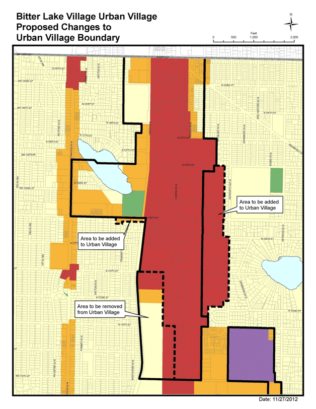
BL-P 38 (( Community Development BL-G16 Support a resilient community rich in different ages, incomes and household types . BL-P39 Create a unified name and identity for the Broadview-Bitter Lake-Haller Lake area, reflecting its history, to nurture neighborhood pride and motivate various groups to come together as one community. BL-P40 Create more opportunities for people to come together where they can meet and get to know their immediate (within a block or so) neighbors. Urban Agriculture BL-G17 Stores, restaurant, and schools that provide healthy food choices. BL-G18 An abundant local food economy that draws from urban agriculture activity in the neighborhood as well as regional food sources. BL-P41 Expand access to locally grown food, by attracting farmers' markets and a wider range of grocery stores. BL-P42 Create opportunities for the community to learn how to establish and maintain urban agriculture practices in the neighborhood through projects such as P-Patches and community gardens, as well as on private property. Tom Hauger; Richard Conlin; Seattle Planning Commission; Rebecca Herzfeld DPD, Comp Plan Amendments ORD ATT E April 24, 2013 Version #7 Attachment E to the DPD Comp Plan Amendments ORD 2013 Attachment F Bitter Lake Village Urban Village Proposed Changes to Future Land Use Map and Urban Village Boundary
Attachment G Rainier Beach Neighborhood Plan Rainier Beach Neighborhood Plan Land Use RB-G1 A diverse and vibrant neighborhood composed of pedestrian-friendly, transit-connected business districts and affordable and attractive residential areas. RB-G2 For Rainier Beach, the "town center" is an interconnected and vibrant set of places where the community comes together. These places reflect the diverse cultures, histories, and traditions that collectively give Rainier Beach its identity .
RB-P1 Encourage the revitalization of the S. Henderson Street corridor as a safe and attractive conduit between the ((
RB-P2 Seek to promote transit-oriented development around Rainier Beach's (( RB-P3 Encourage mixed-use housing and commercial development in the "Beach Square" area bounded by S. Henderson Street to the north, Rainier Avenue South to the south and west, and Seward Park Avenue South to the east.
RB-P4 Seek to preserve the character of Rainier Beach's (( RB-P5 Encourage the City to support rezones within the Rainier Beach Residential Urban Village for projects that: A. meet the overall community vision, B. promote redevelopment of underutilized and derelict sites, and C. result in pedestrian-friendly, well designed new buildings. Transportation and Transit Facilities
RB-G 3 (( RB-G4 Integrated transportation improvements that serve the community.
RB-P 6 ((
RB-P 7 ((
RB-P 8 ((
RB-P 9 (( RB-P9 Coordinate transportation improvements with other infrastructure and programmatic actions (such as public art, parks, or economic development) so that those improvements contribute positively to the neighborhood's identity. Housing
RB-G 5 (( RB-G6 Retain and develop affordable (low and moderate income) housing, especially where such housing is accessible to transit.
RB-P 10 ((
RB-P 11 ((
RB-P 12 ((
RB-P 13 (( RB-P14 Increase opportunities for home-occupation, and live-work development that allows ground floor business including small-scale retail and services in the station area and along S. Henderson St. RB-P15 Encourage affordable family sized units through incentives, direct City funding, and reuse of publicly owned property. Capital Facilities
RB-G 7 (( RB-P16 Support the Rainier Beach Urban Farm and Wetland Project to convert the Parks Department's Atlantic Street Nursery into an urban farm and wetlands restoration project.
RB-P 17 ((
RB-P 18 ((
RB-P 19 (( RB-G8 Connected parks and open space that serve the community. RB-P20 Improve connections to, and circulation within, public spaces (South Shore k-8, Rainier Beach Playfield, Rainier Beach High School and between Beer Sheva and Pritchard Beach). RB-G9 Use the arts and public art, in particular, to engage and express Rainier Beach's cultural diversity.
RB-P2 1 ((
RB-P2 2 (( Economic Development
RB-G 10 ((
RB-P 23 (( RB-P24 Support and expand the existing character and diverse mix of small-scale, minority and immigrant-owned businesses nodes around Rainier Ave S and S Rose Street; Rainier Ave South and 56 th /57 th Ave. South; and the rail station.
RB-P 25 (( RB-G11 A strong local economy for Rainier Beach. RB-G12 Strong entrepreneurship that creates jobs and grows the local economy RB-P26 As part of community development, seek to provide programs that equip individuals and families with the tools for achieving sustainable wealth creation; managing their money; making sound financial decisions; and building wealth. RB-P27 Consider strategies for employing youth when funding and implementing economic development programs. RB-P28 Encourage Sound Transit to develop its properties south of the rail station in ways that create permanent, wellpaying jobs. RB-P29 Build on the asset of community diversity and consider the specific needs of minority and immigrant-owned businesses when undertaking economic development. RB-P30 Use streetscape improvements to enhance the character of the town center and support small, locally-owned businesses located there. Human Development RB-G13 Strong schools with excellent programs and strong enrollment, that encourage and support the educational development of exceptional students.
RB-G 14 ((
RB-P 3 ((
RB-P 32 (( RB-P33 Seek to attract a community college facility that serves the Rainier Beach community in order to offer local college level studies and to establish connections to fouryear colleges.
RB-P 34 ((
RB-P 35 ((
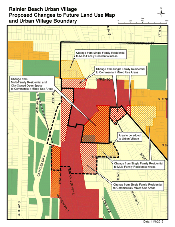
RB-P 36 (( RB-G15 Strong institutions and activities that engage and support Rainier Beach youth. RB-G16 Ready access to healthy food. RB-G17 Community-based implementation of neighborhood plan recommendations and other community projects. RB-G18 Neighborhood spaces that support Rainier Beach's many cultures. RB-G19 Arts and public art, in particular, are used to engage and express Rainier Beach's cultural diversity. RB-P37 Work with existing community organizations and/or create new community organizations to implement plan update recommendations. RB-G20 A positive identity for Rainier Beach based on its unique strengths. RB-P38 Use public relations strategies to highlight Rainier Beach's community identity as a thriving and interconnected community with diverse households and supported by strong social and cultural institutions and services. RB-G21 A safe Rainier Beach neighborhood. RB-P39 Improve public safety when implementing any project or program within the community. RB-P40 Build and sustain a positive relationship between Seattle Police and the diverse cultures in Rainier Beach. Tom Hauger; Richard Conlin; Seattle Planning Commission DPD Comp Plan Amendments 2013 ORD ATT G v5.docx April 5, 2013 Version #5 Attachment G to DPD Comp Plan Amendments 2013 ORD Attachment H Rainer Beach Urban Village Proposed Changes to Future Land Use Map and Urban Village Boundary
Tom Hauger DPD Comp Plan Amendments 2013 ORD November 29, 2012 Version # 2 |
|||||||||||||||||||||||||||||||||||||||||||||||
Attachments |
|---|
![[TOP]](/netaicon/toppg.gif)